Items Similar to Map of The East Indies with the Route of Capt. William Dampier's Voyage, 1698


Want more images or videos?
Request additional images or videos from the seller
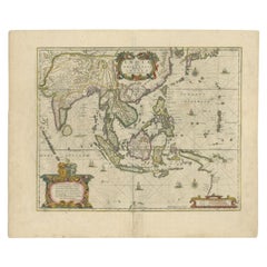
Map of The East Indies with the Route of Capt. William Dampier's Voyage, 1698
About the Item
Antique map titled 'Kaart van Oost Indie'.
Old map of the East Indies. It shows the routes of Captain William Dampier's voyage throughout the region. Dotted lines delineates explorations from Guam, through the East Indies, the Philippines, Formosa (Taiwan), Indochina, the Gulf of Siam, and touching Northern Australia (Nouvelle Hollande). This was the first British scientific expedition to the region, gathering important data on the flora and fauna of Australia and New Guinea. This map originates from the rare Dutch edition of 'A New Voyage Round the World' by W. Dampier.
Artists and engravers: William Dampier (baptized 1651-1715) was a buccaneer (pirate) and sea captain. He was the first Englishman to explore parts of New Holland and New Guinea, and was the first man to circumnavigate the world three times. In the 1670s he crewed with buccaneers on the Spanish Main of Central America, which eventually led to his first circumnavigation. On the ship Cygnet, following Pacific-spanning raids that included the East Indies, Manila, and the Spice Islands, Dampier's ship was beached on the northwest coast of Australia in 1688. Waiting for repairs, his scientific interest surfaced as he made notes and drawings on the local fauna and flora. Following three years of further adventures he returned to England. In 1697 he published his experiences in A New Voyage. Described as one of the greatest tales of adventure and exploration ever written, the book was published in several languages. It is reported that Captain Cook used Dampier's nautical observations on his voyages, and Charles Darwin found his books so useful that he took them aboard the Beagle.
- Dimensions:Height: 7.88 in (20 cm)Width: 12.41 in (31.5 cm)Depth: 0 in (0.02 mm)
- Materials and Techniques:
- Period:1690-1699
- Date of Manufacture:1698
- Condition:Wear consistent with age and use. Condition: Good, general age-related toning. Some creasing, please study image carefully.
- Seller Location:Langweer, NL
- Reference Number:
About the Seller
5.0
Platinum Seller
These expertly vetted sellers are 1stDibs' most experienced sellers and are rated highest by our customers.
Established in 2009
1stDibs seller since 2017
1,950 sales on 1stDibs
Typical response time: <1 hour
- ShippingRetrieving quote...Ships From: Langweer, Netherlands
- Return PolicyA return for this item may be initiated within 14 days of delivery.
More From This SellerView All
- Detailed Map of New Zealand Showing the Route of Capt. Cook's First Voyage, 1803Located in Langweer, NLAntique map New Zealand titled 'De Rivier de Theems en Mercurius Baai in Nieuw Zeeland'. Detailed map of New Zealand showing the route of Capta...Category
Antique 19th Century Maps
MaterialsPaper
- Large Antique Map of the East Indies, with Inset of the PhilippinesLocated in Langweer, NLAntique map titled 'A Map of the East Indies (..)'. Large antique map of Southeast Asia, India, and part of China, extending to Tibet, the Maladives, Sumatra, part of Borneo, Hainan,...Category
Antique Late 18th Century Maps
MaterialsPaper
- Antique Map of the East Indies by A & C. Black, 1870Located in Langweer, NLAntique map titled 'Indian Archipelago and Further India including Burmah, Siam, Anam &c'. Original antique map of Indian Archipelago and Further India. This map originates from ‘Bla...Category
Antique Late 19th Century Maps
MaterialsPaper
- Antique Map of the East Indies by Bonne '1776'Located in Langweer, NLAntique map titled 'Indes IVe Feuille'. Very decorative original antique map of the East Indies. Covbers from the Gulf of Siam (Gulf of Thailand) and Malacca (Malaysia) eastward to i...Category
Antique Late 18th Century Maps
MaterialsPaper
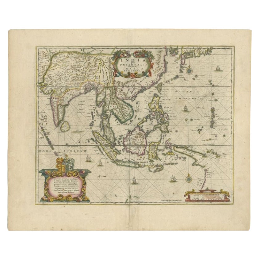
- Antique Map of the East Indies by Janssonius, c.1644By Johannes JanssoniusLocated in Langweer, NLAntique map titled 'India quae Orientalis dicitur, et Insulae adiacentes'. Old map of the East Indies and Southeast Asia showing the area between India in the West and parts of Japan...Category
Antique 17th Century Maps
MaterialsPaper
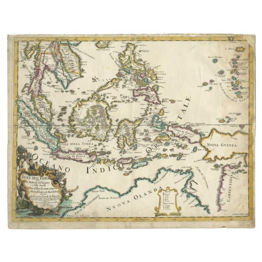
- Antique Map of the East Indies by Rossi, 1683Located in Langweer, NLAntique map titled 'Isole Dell'India cioe le Molucche la Filippine e della Sonda Parte de Paesi di nuova scoperta e l'Isole de Ladri ne Mare del Zud (..)'. Decorative map of Southeas...Category
Antique 17th Century Maps
MaterialsPaper


You May Also Like
- Original Antique Map of South East Asia, Arrowsmith, 1820Located in St Annes, LancashireGreat map of South East Asia Drawn under the direction of Arrowsmith Copper-plate engraving Published by Longman, Hurst, Rees, Orme and Brown, 1820 Unframed.Category
Antique 1820s English Maps
MaterialsPaper
- Map of the Republic of GenoaLocated in New York, NYFramed antique hand-coloured map of the Republic of Genoa including the duchies of Mantua, Modena, and Parma. Europe, late 18th century. Dimension: 25...Category
Antique Late 18th Century European Maps
- Original Antique Map of South East Asia by Thomas Clerk, 1817Located in St Annes, LancashireGreat map of South East Asia Copper-plate engraving Drawn and engraved by Thomas Clerk, Edinburgh. Published by Mackenzie And Dent, 1817 Unframed.Category
Antique 1810s English Maps
MaterialsPaper
- Original Antique Map of South East Asia by Becker, circa 1840Located in St Annes, LancashireGreat map of South East Asia Steel engraving with original color outline Engraved by Becker Published by Virtue, circa 1840. Unframed.Category
Antique 1840s English Other Maps
MaterialsPaper
- Map "Estuary- Mouth of the Thames"Located in Alessandria, PiemonteST/426 - Antique French Map of the estuary of the Thames, map dated 1769 - "Mape of the entrance of the Thames. Designed by filing of Navy cards fo...Category
Antique Mid-18th Century French Other Prints
MaterialsPaper
- Original Antique English County Map, East Yorkshire, J & C Walker, 1851Located in St Annes, LancashireGreat map of The East Riding of Yorkshire Original colour By J & C Walker Published by Longman, Rees, Orme, Brown & Co. 1851 Unframed.Category
Antique 1850s English Other Maps
MaterialsPaper


Recently Viewed
View AllMore Ways To Browse
Antique Voyage
Voyage Antique
Man Of The Sea
East Indies Furniture
East Indies
Philippines Antique
Antique Philippines
Filipino Antique
Antique Maps Of Britain
Antique Filipino Furniture
Old American Maps
Dutch Indies
Antique Ship Parts
New England Maps
New England Map
World Map British
Rare Antique Nautical
Antique Collectables Australia