Items Similar to Map Silk Embroidered Western Eastern Hemisphere New Old World Asia America Afri


Want more images or videos?
Request additional images or videos from the seller
1 of 15
Map Silk Embroidered Western Eastern Hemisphere New Old World Asia America Afri
About the Item
A rare, late-18th century, silk, embroidered, double hemisphere, world map, blackwork, sampler, showing the tracks of captain cook’s three voyages
- Illustrating public understanding of the world in the late-18th century and the recent discoveries of the time delineating the tracks of Captain Cook’s three voyages.
- Shows the incentive for further exploration during the 19th century as no mass is indicated within the southern polar region, the interior portions of western North America, Africa, and Australia are still relatively void of detail even though California is no longer shown as an island.
- Includes beautifully worked allegories of the four continents Asia, the Americas, Africa & Europe, a cartouche being supported by two angels and a compass
- The cream, silk ground is finely embroidered with a variety of stiches in black, silk threads emulating the black ink on maps.
-“Recent international conflicts and voyages by Captain Cook and others made the study of geography exciting at the time this map was made. Elaborate embroidered maps … were executed by wealthy girls in formal academic settings using costly materials such as satin and silk. Such projects were designed to combine instruction in both geography and needlework, as sewing skills were essential for the production of clothing and monogramming linens at the time.” (Norman B. Leventhal Map Center)
Related maps
Distressed map dated 1783, Metropolitan Museum, 57.122.212. Dimensions: 16 1/4 in. × 27 in. (41.3 × 68.6 cm)
Museum of New Zealand, GH016925, Frame: 520mm (width), 860mm (height), 35mm (depth)
The World, sampler, unknown maker, late 18th century, England. Museum no.. © Victoria and Albert Museum, T.44-1951. Height: 45cm Width: 64cm
Leventhal Map Centre, Boston Public Library.
- Dimensions:Height: 0.4 in (1 cm)Width: 0.4 in (1 cm)Depth: 0.4 in (1 cm)
- Style:Georgian (Of the Period)
- Materials and Techniques:Silk,Needlework
- Place of Origin:
- Period:
- Date of Manufacture:1790
- Condition:Wear consistent with age and use.
- Seller Location:BUNGAY, GB
- Reference Number:1stDibs: LU3867331964392
About the Seller
5.0
Vetted Seller
These experienced sellers undergo a comprehensive evaluation by our team of in-house experts.
Established in 1985
1stDibs seller since 2018
84 sales on 1stDibs
Typical response time: 13 hours
- ShippingRetrieving quote...Ships From: BUNGAY, United Kingdom
- Return PolicyA return for this item may be initiated within 7 days of delivery.
More From This SellerView All
- Map Bedfordshire General FramedLocated in BUNGAY, SUFFOLKA general map of Bedfordshire with its hundreds A scale of 5 miles in the original green mount and traditional black and gold frame. Measures: 36cm 14" high.Category
Antique 18th Century English Georgian Maps
MaterialsPaper
- Bedspread TableCloth Gold Threadwork Wirework Velvet Ottoman Baroque EmbroideredLocated in BUNGAY, SUFFOLKAn exceptional, museum quality, ottoman, baroque, gold velvet bedspread, hanging, bedcover or table cloth embroidered with gold threadwork and embelli...Category
Antique 1720s Turkish Baroque Pillows and Throws
MaterialsGold
- Map Bedfordshire No 3 General FramedLocated in BUNGAY, SUFFOLKA general map of Bedfordshire with its hundreds. Measure: 37cm 14 1/2" high A scale of 5 miles. in the original green mount and traditional black and gold frame. charming map with...Category
Antique 18th Century English Georgian Maps
MaterialsPaper
- Map North Wales Robert Marsden AngleseyLocated in BUNGAY, SUFFOLKMap of North Wales by Robert Marsden Including Anglesey Charming topography and detail and colouring just purchased more information to follow.Category
Antique 18th Century English Georgian Maps
MaterialsPaper
- Map Jersey Guernsey Scilly Islands AlderneyLocated in BUNGAY, SUFFOLKRare map of The Islands of Guernsey and Jersey, including Alderney & the Scilly Islands just purchased more information to follow In the original cream mount and gilded frame.Category
Antique 18th Century English Georgian Maps
MaterialsPaper
- Map SussexLocated in BUNGAY, SUFFOLKMap of Sussex with explanation Maker unknown.Category
Antique 19th Century English Victorian Maps
MaterialsPaper


You May Also Like
- Antique Map of the Eastern Hemisphere by Wyld '1845'Located in Langweer, NLAntique map titled 'Eastern Hemisphere'. Original antique map of the eastern hemisphere. This map originates from 'An Atlas of the World, Comprehending Separate Maps of its...Category
Antique Mid-19th Century Maps
MaterialsPaper
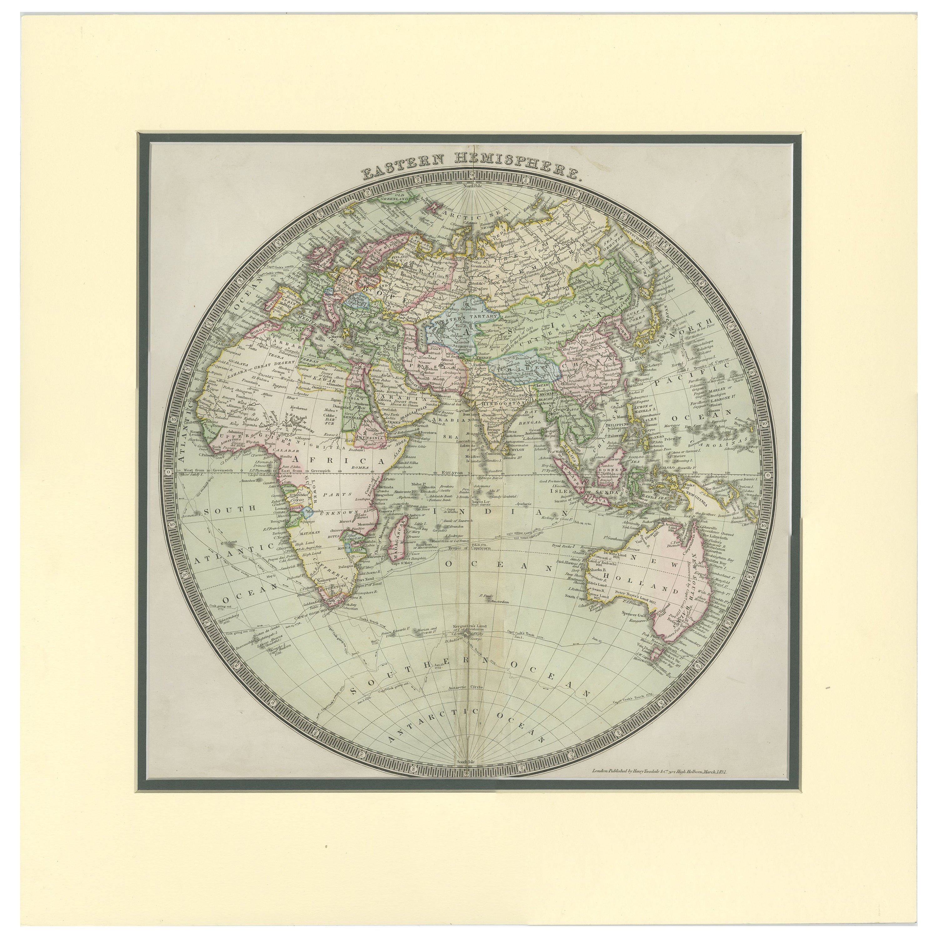
- Antique Map of the Eastern Hemisphere by Teesdale, '1831'Located in Langweer, NLAntique map titled 'Eastern Hemisphere'. Hemispherical map of eastern hemisphere showing tracks of the navigators James Cook and John Gore. Plate 1 fro...Category
Antique Mid-19th Century Maps
MaterialsPaper
- Antique Map of the Eastern Hemisphere by Wyld, 1842Located in Langweer, NLAntique map titled 'Eastern Hemisphere'. Large map depicting the continents Europe, Asia, Afrika and Australia. Artists and Engravers: James Wyld (1812–1887) was a British geograph...Category
Antique 19th Century Maps
MaterialsPaper
- Antique Map of the Western Hemisphere by Wyld '1845'Located in Langweer, NLAntique map titled 'Western Hemisphere'. Original antique map of the western hemisphere. This map originates from 'An Atlas of the World, Comprehending Separate Maps of its...Category
Antique Mid-19th Century Maps
MaterialsPaper
- Antique Map of the Eastern Hemisphere by Valk & Chenk '1708'Located in Langweer, NLAntique map titled 'Hemispherium Orbis Antiqui, Cumzonis Circulis, Et Sity populorum Diverso'. Decorative example of Andreas Cellarius's map of the Eastern Hemisphere, illustrating with climatic zones ranging from Frigida Borealis to Torrida, with planetary details superimposed. The elaborate border includes fine scrollwork, numerous putti, and additional diagrams showing armillary spheres and climatic zones. Andreas Cellarius was born in 1596 in Neuhausen and educated in Heidelberg. He emigrated to Holland in the early 17th century and 1637 moved to Hoorn, where he became the rector of the Latin School. Cellarius' best known work is his Harmonia Macrocosmica, first issued in 1660 by Jan Jansson, as a supplement to Jansson's Atlas Novus. The work consists of a series of Celestial Charts...Category
Antique Early 18th Century Maps
MaterialsPaper
- Antique Map of the Eastern Hemisphere in Frame, 'circa 1683'Located in Langweer, NLAntique map titled 'Climats selon les Anciens'. Miniature map of the Eastern Hemisphere showing the climatic regions. This map originates from 'Description de l'Univers' by A.M. Mall...Category
Antique Late 17th Century Maps
MaterialsPaper


Recently Viewed
View AllMore Ways To Browse
Old World Furniture
Old World Design
18th Century Silk
Old World European
Southern America Furniture
Southern American Furniture
Antique Silk Thread
Eastern European Furniture
Antique Needlework
Needlework Antique
Needlework Design
Monogram Silk
Southern New And Used Furniture
Antique Embroidered Linens
American Georgian Furniture
Distressed Silk
Center 44
Silk Girl