Items Similar to Original Antique Sea Chart of the Northern Part of Hispaniola, Western Cuba


Want more images or videos?
Request additional images or videos from the seller
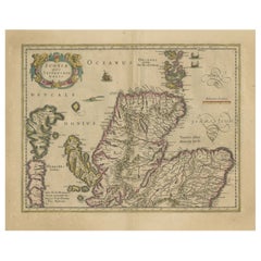
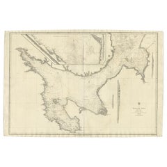
Original Antique Sea Chart of the Northern Part of Hispaniola, Western Cuba
About the Item
Antique map titled 'Pas kaart van de Noord Kust van Espaniola (..)'. Beautiful sea chart of the northern part of Hispaniola, western Cuba. The map includes the Turks & Caicos Islands and southern part of the Bahamas. Shows Guanahami or S. Salvador. Guanahani is an island in the Bahamas that was the first land in the New World sighted and visited by Christopher Columbus' first voyage, on October 12, 1492. It is not known precisely which island it was, and several theories have been put forth by historians. Guanahani is the native Taíno name; Columbus called it San Salvador. Originates from 'De Nieuwe Groote Lightende Zee-Fakkel'. Published by J. van Keulen, circa 1684.
The Van Keulens were a family of chartmakers and publishers. The firm, In de Gekroonde Lootsman (In the Crowned Pilot), was founded in 1678 by Johannes van Keulen (1654-1715). Van Keulen originally registered his business as a vendor of books and instruments (specifically cross-staffs). In 1680, however, he gained a privilege from the States of Holland and West Friesland for the publication of pilot guides and sea atlases.
In that year, van Keulen released his Zee-Atlas (Sea Atlas), which secured him a name in the competitive maritime publishing market. In 1681, he published the first volume of Nieuwe Lichtende Zee-Fakkel (New Shining Sea Torch). This would be the first of an eventual five volumes originally published between 1680 and 1684. A sixth volume was added in 1753. The Zee-Fakkel won van Keulen lasting fame. The atlas had charts compiled by Claes Jansz Vooght and artwork from Jan Luyken. It proved immensely popular and was reprinted until 1783. There were translations in French, English, Spanish, and Italian.
- Dimensions:Height: 21.26 in (54 cm)Width: 24.02 in (61 cm)Depth: 0.02 in (0.5 mm)
- Materials and Techniques:
- Period:Late 17th Century
- Date of Manufacture:circa 1684
- Condition:Additions or alterations made to the original: Top margin has been extended, repair on central vertical line. Both professional, and hardly visible. Wear consistent with age and use. General age-related toning. Later hand coloring, blank verso. Few small tears, mainly in bottom margin. Top margin has been extended, repair on central vertical line. Both professional, and hardly visible. Please study images carefully.
- Seller Location:Langweer, NL
- Reference Number:
About the Seller
5.0
Platinum Seller
These expertly vetted sellers are 1stDibs' most experienced sellers and are rated highest by our customers.
Established in 2009
1stDibs seller since 2017
1,951 sales on 1stDibs
Typical response time: <1 hour
- ShippingRetrieving quote...Ships From: Langweer, Netherlands
- Return PolicyA return for this item may be initiated within 14 days of delivery.
More From This SellerView All
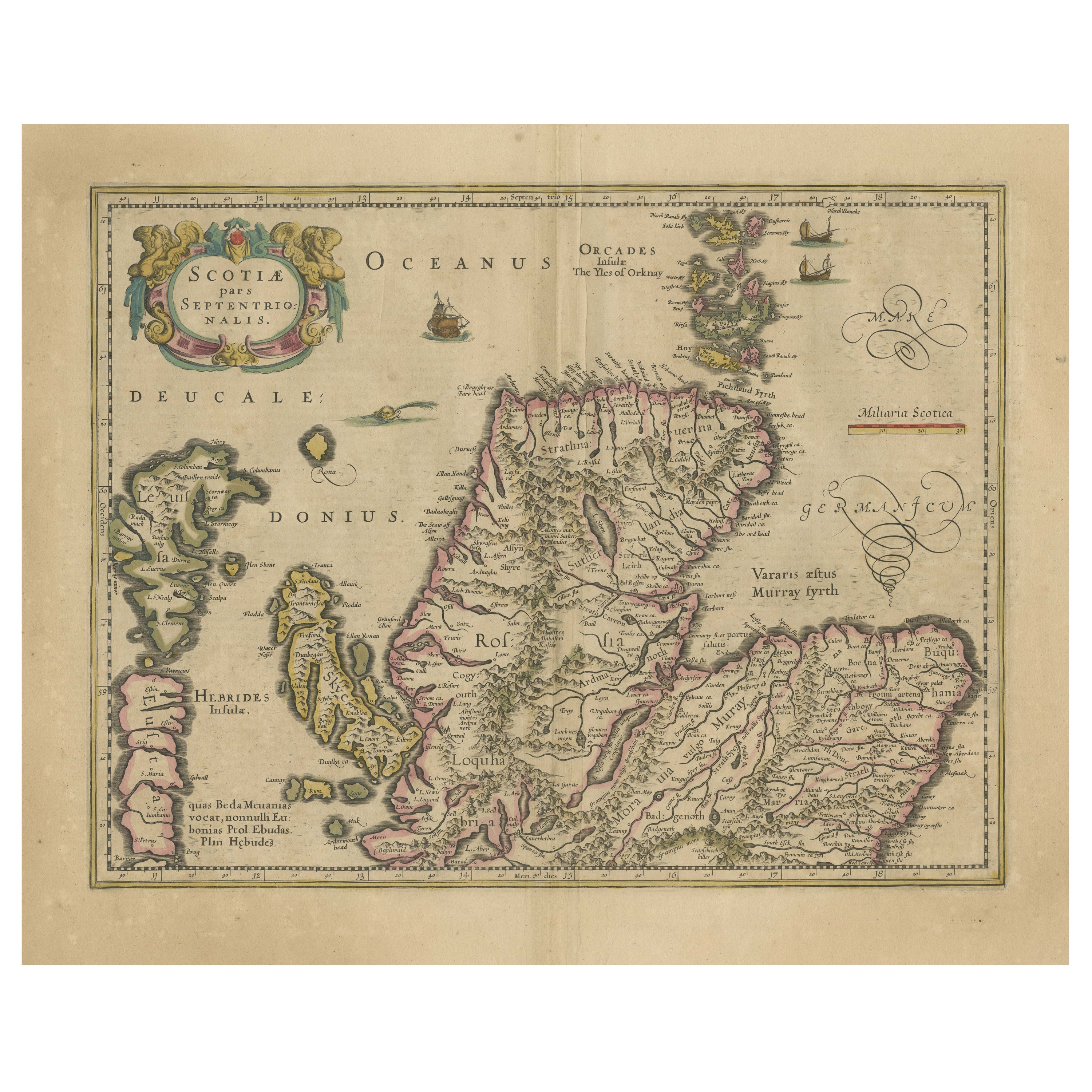
- Original Antique Map of the Northern Part of Scotland, circa 1640Located in Langweer, NLThe antique map, titled 'Scotiae pars septentrionalis,' depicts the northern part of Scotland. Crafted by Hondius around 1640, this map is a historical treasure showcasing the geogra...Category
Antique Mid-17th Century Maps
MaterialsPaper
- Antique Engraved Map of the Northern Part of Greece and the Aegean Sea, Ca.1730Located in Langweer, NLTitle: "GRÆCIÆ PARS Septentrionalis". Hand Coloured Engraved map by G. Delisle of the northern part of the Aegean. In the top left corner a distance scale included. Condition...Category
Antique 1730s Maps
MaterialsPaper
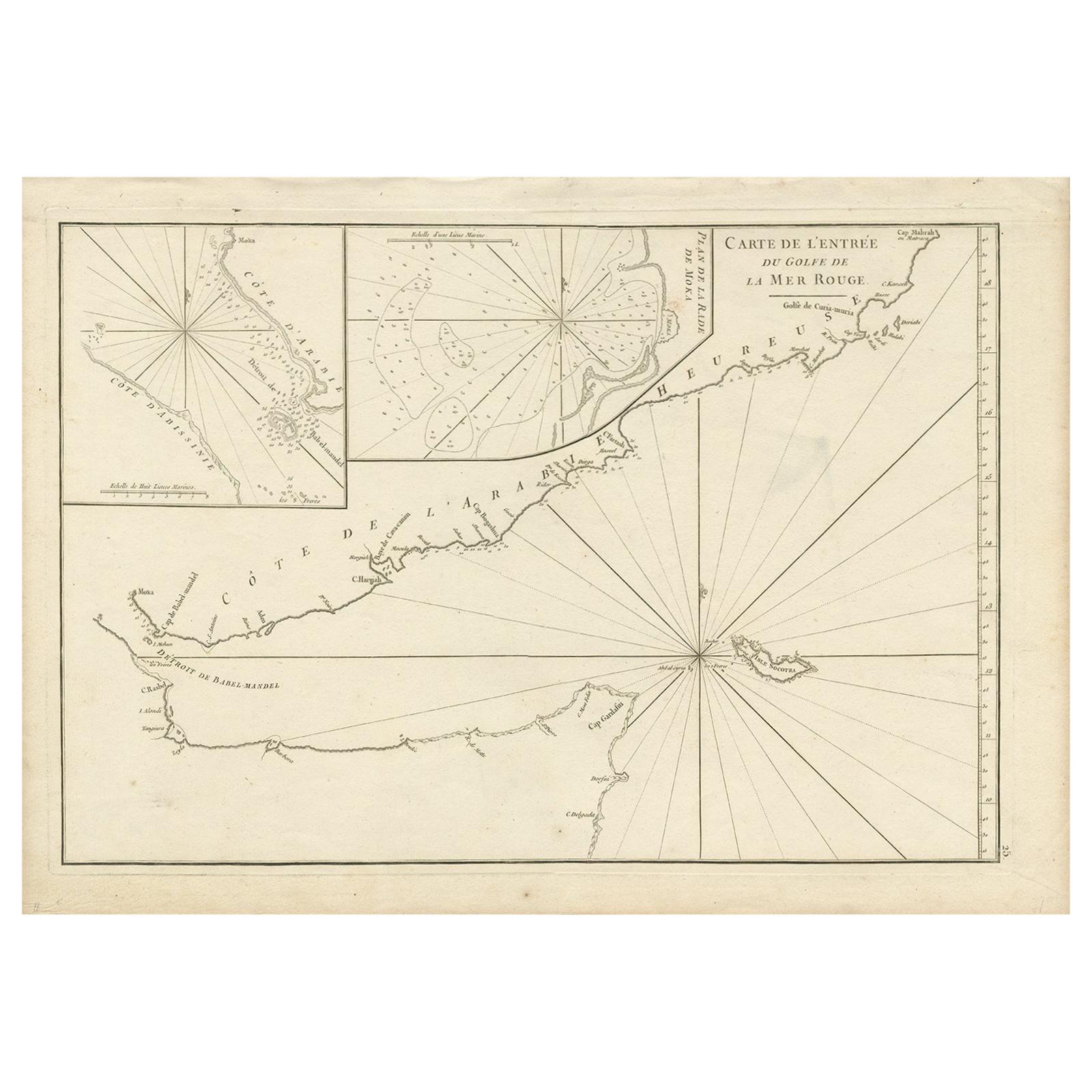
- Original Antique Engraved Map of Part of the Red Sea, Arabia, 1775Located in Langweer, NLAntique map titled 'Carte de l'Entrée du Golfe de la Mer Rouge'. Uncommon sea chart of the entrance to the Red Seas as far as Mocha, with rhumb lines and soundings. Two insets of the...Category
Antique Late 18th Century Maps
MaterialsPaper
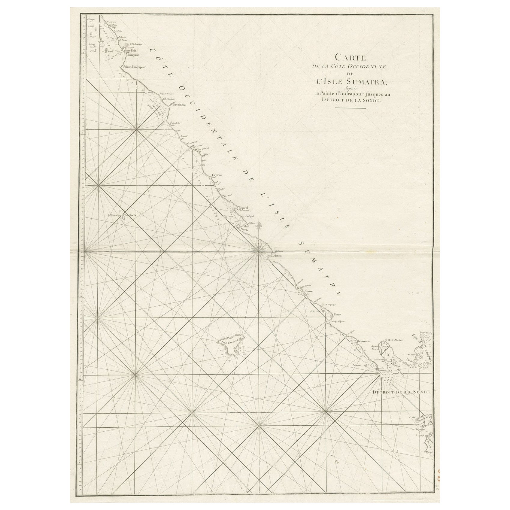
- Sea Chart of Part of the Southwestern Coast of Sumatra & Nias, Indonesia, C1775Located in Langweer, NLAntique map titled 'Carte de la Côte Occidentale de l'Isle Sumatra'. Sea chart of the part of the south-western coast of Sumatra with the Nassau (Nias) and Fortune isles. Artists ...Category
Antique 1770s Maps
MaterialsPaper
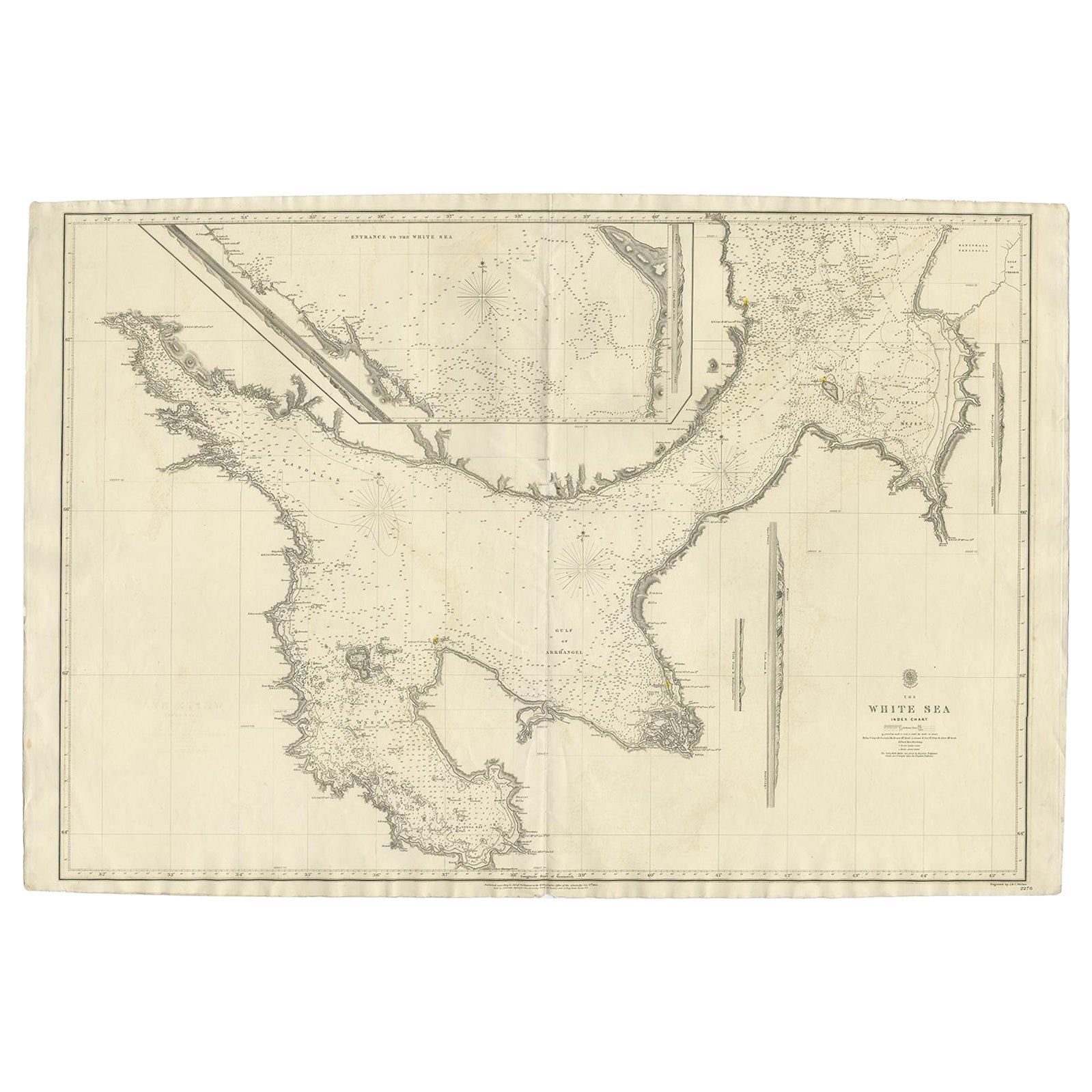
- Large Antique Chart of The White Sea, Russa 1854Located in Langweer, NLAntique map titled 'The White Sea Index Chart'. Large uncommon map of the White Sea with a smaller inset map of the entrance to the White Sea. The white sea is a southern inlet of th...Category
Antique 19th Century Maps
MaterialsPaper
- Antique Map of the Northern Part of Scotland by Black '1854'Located in Langweer, NLAntique map titled 'Scotland'. Original map of the northern part of Scotland. With an inset map of the Orkney Isles. This map originates from 'General Atlas Of The World: Containing ...Category
Antique Mid-19th Century Maps
MaterialsPaper

You May Also Like
- Antique Anatomical Wall Chart Depicting the Human SkeletonLocated in Berghuelen, DEA rare 19th century anatomical wall chart depicting the human skeleton. On the sides On the sides are detailed description in German language. The wall...Category
Early 20th Century German Victorian Prints
MaterialsPaper
- American Western Movie Lithograph "The Treasure of the Sierra Madre", SignedLocated in Miami, FLA very nice Hollywood movie original lithograph for the film The Treasure of the Sierra Madre, directed by John Huston. Starring Humphrey Bogart, Walter H...Category
Early 20th Century American Prints
MaterialsPaper
- Original Antique Map of The World by Thomas Clerk, 1817Located in St Annes, LancashireGreat map of The Eastern and Western Hemispheres On 2 sheets Copper-plate engraving Drawn and engraved by Thomas Clerk, Edinburgh. Published by Mackenzie And Dent, 1817 ...Category
Antique 1810s English Maps
MaterialsPaper
- Antique Foldable Anatomical Wall Chart Depicting Human MusculatureLocated in Berghuelen, DEAntique Foldable Anatomical Wall Chart Depicting Human Musculature The rare 19th century anatomical wall chart depicts the human musculature and inter...Category
Early 20th Century German Victorian Prints
MaterialsWood, Paper
- Original Antique Map of The Netherlands, Sherwood, Neely & Jones, Dated 1809Located in St Annes, LancashireGreat map of The Netherlands Copper-plate engraving by Cooper Published by Sherwood, Neely & Jones. Dated 1809 Unframed.Category
Antique Early 1800s English Maps
MaterialsPaper
- Original Antique Map of The Netherlands, Engraved by Barlow, Dated 1807Located in St Annes, LancashireGreat map of Netherlands Copper-plate engraving by Barlow Published by Brightly & Kinnersly, Bungay, Suffolk. Dated 1807 Unframed.Category
Antique Early 1800s English Maps
MaterialsPaper


Recently Viewed
View AllMore Ways To Browse
Sea Antique
Northern French Furniture
Cuban Antique
Antique Cuban Furniture
Cross And Crown
Southern New And Used Furniture
Italian Chart
Cuban Antiques
Antique Cuba
Used Furniture Columbus
Used Furniture In Columbus
Antique Columbus
Northern France Map
J Christopher
Dutch Maritime
Antique Vendor
Antique Vendors
Antique Furniture Columbus