Items Similar to Rare Antique Map of the Dutch East Indies 'Indonesia', 1774


Want more images or videos?
Request additional images or videos from the seller
1 of 6
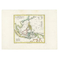
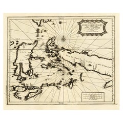
Rare Antique Map of the Dutch East Indies 'Indonesia', 1774
About the Item
Rare decorative engraved map of the Dutch East Indies, or nowadays Indonesia.
Title (in old Dutch): NIEUWE EN NAUKEURIGE KAART DER OOST-INDISCHE EILANDEN volgens de laatste ontdekkingen, uit de beste Land- en Zeekaarten opgemaakt, en in gevolge der nieuwste Starrekundige waarneemingen in orde gebragt door Eman. Bowen, verbeterd door W.A. Bachiene.
Engr. by J. van Jagen, 1774.
- Dimensions:Height: 23.82 in (60.5 cm)Width: 18.12 in (46 cm)Depth: 0 in (0.02 mm)
- Materials and Techniques:
- Period:1770-1779
- Date of Manufacture:1774
- Condition:Condition: Good. Folding line in the middle as issued. Image clean with no defects. Outer borders a few tiny wormholes, some damp spots on the right and a tear in the lower fold, all far from the image. Overal a very nice map. Study image carefully.
- Seller Location:Langweer, NL
- Reference Number:
About the Seller
5.0
Platinum Seller
These expertly vetted sellers are 1stDibs' most experienced sellers and are rated highest by our customers.
Established in 2009
1stDibs seller since 2017
1,957 sales on 1stDibs
Typical response time: <1 hour
- ShippingRetrieving quote...Ships From: Langweer, Netherlands
- Return PolicyA return for this item may be initiated within 14 days of delivery.
More From This SellerView All
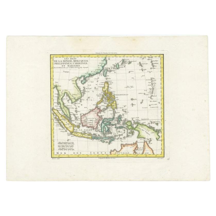
- Antique Colourful Map of the Dutch East Indies 'Indonesia', ca.1806Located in Langweer, NLAntique map titled 'Les Isles de la Sonde Moluques Philippines, Carolines et Marianes'. Old map of the East Indies, also showing a part of Australia. Artists and Engravers: Publi...Category
Antique 19th Century Maps
MaterialsPaper
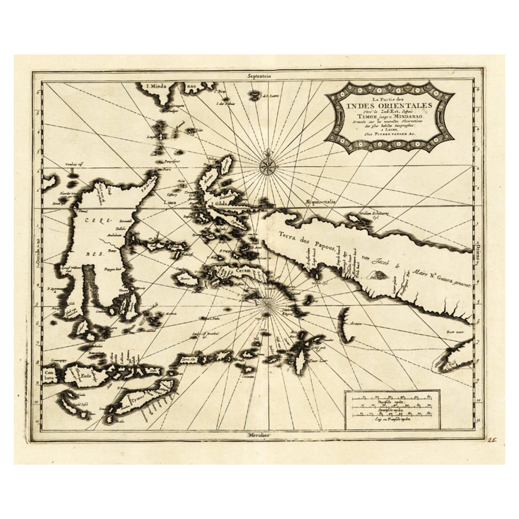
- Extremely Rare Map of the East-Indies towards the South-East 'Indonesia', 1725Located in Langweer, NLAntique map titled 'La partie des Indes Orientales vers le Zud-Est, depuis Timor jusqu'a Midanao (...).' (The part of the East-Indies towards the South-East, from Timor to Mindanao.)...Category
Antique 1720s Maps
MaterialsPaper
- Antique Map of Batavia, Dutch East Indies, Nowadays Jakarta, Indonesia, ca.1669Located in Langweer, NLAntique map titled 'Ware afbeeldinge wegens het Casteel ende Stadt Batavia gelegen opt groot Eylant Java Anno 1679. Plan de la Ville et du Chateau de Batavia en l'Isle de Iava. 1679....Category
Antique 1660s Maps
MaterialsPaper
- Original Old Map of the Environs of Batavia in the Dutch East Indies (Indonesia)Located in Langweer, NLAntique map titled 'Carte des Environs de Batavia'. Map of the environs of Batavia (now Jakarta), Indonesia. This print originates from volume 8 of 'Histoire générale des voyages'. P...Category
Antique Mid-18th Century Maps
MaterialsPaper
- Original Antique Map of the East Indies (Indonesia) by Janssonius, c.1644By Johannes JanssoniusLocated in Langweer, NLAntique map titled 'India quae Orientalis dicitur, et Insulae adiacentes'. Old map of the East Indies and Southeast Asia showing the area between India in the West and parts of Japan...Category
Antique 17th Century Maps
MaterialsPaper
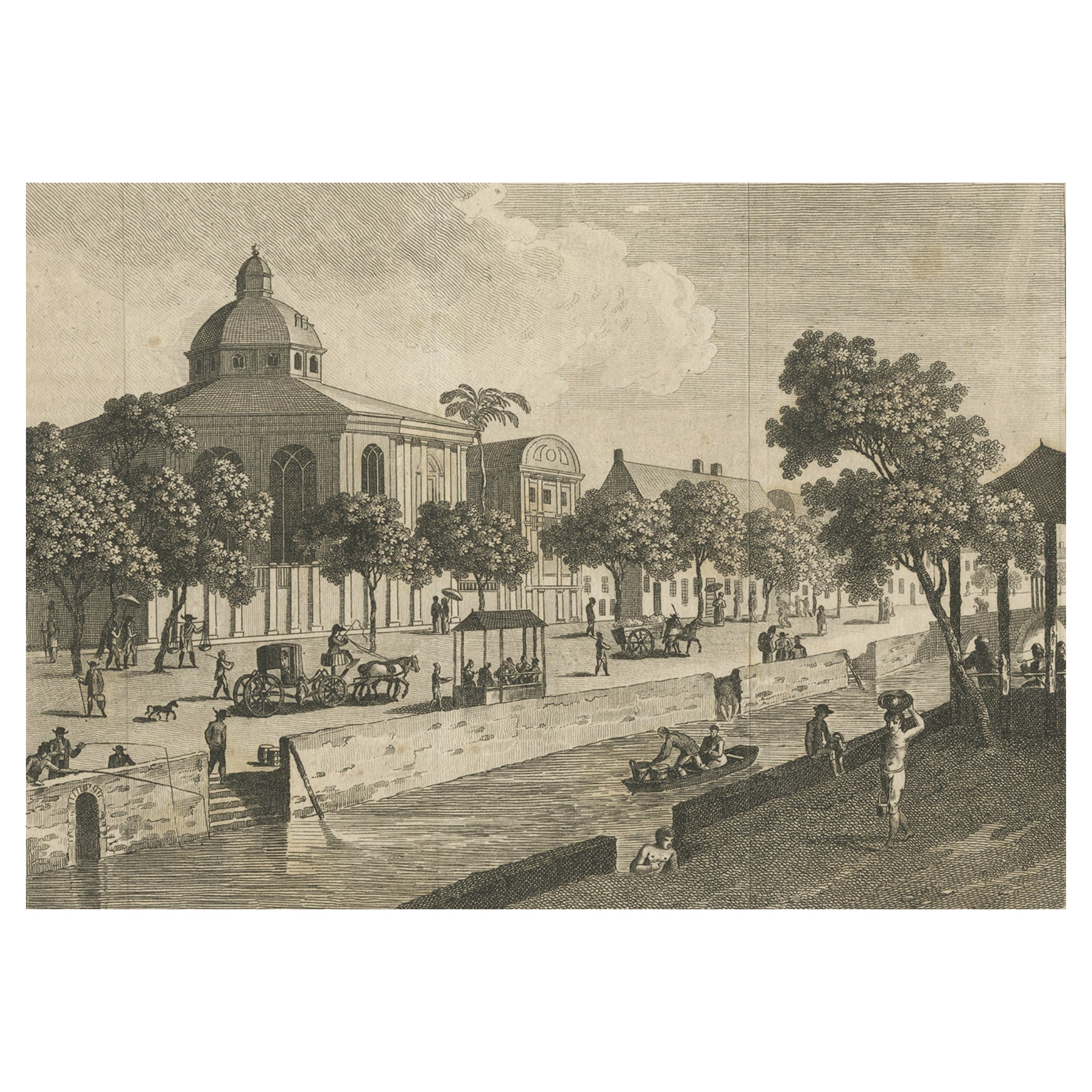
- Antique Print of Batavia, Capital of the Dutch East Indies 'Indonesia', c.1820Located in Langweer, NLAntique print titled 'Ansicht einer Strasse in Batavia'. Old print with a view on a street in Batavia (Jakarta), Indonesia. Source unknown, to be determined. Artists and Engraver...Category
Antique 19th Century Prints
MaterialsPaper


You May Also Like
- Original Antique Map of South East Asia, Arrowsmith, 1820Located in St Annes, LancashireGreat map of South East Asia Drawn under the direction of Arrowsmith Copper-plate engraving Published by Longman, Hurst, Rees, Orme and Brown, 1820 Unframed.Category
Antique 1820s English Maps
MaterialsPaper
- Original Antique Map of South East Asia by Becker, circa 1840Located in St Annes, LancashireGreat map of South East Asia Steel engraving with original color outline Engraved by Becker Published by Virtue, circa 1840. Unframed.Category
Antique 1840s English Other Maps
MaterialsPaper
- Original Antique Map of South East Asia by Thomas Clerk, 1817Located in St Annes, LancashireGreat map of South East Asia Copper-plate engraving Drawn and engraved by Thomas Clerk, Edinburgh. Published by Mackenzie And Dent, 1817 Unframed.Category
Antique 1810s English Maps
MaterialsPaper
- Original Antique English County Map, East Yorkshire, J & C Walker, 1851Located in St Annes, LancashireGreat map of The East Riding of Yorkshire Original colour By J & C Walker Published by Longman, Rees, Orme, Brown & Co. 1851 Unframed.Category
Antique 1850s English Other Maps
MaterialsPaper
- The Holy Land at the Time of Jesus: A 17th Century Dutch Map by VisscherBy Nicolaes Visscher IILocated in Alamo, CAThis detailed Dutch map entitled "Het Beloofe de Landt Canaan door wandelt van onsen Salichmaecker Iesu Christo, nessens syne Apostelen" by Nicolaes Visscher was published in Amsterd...Category
Antique Mid-17th Century Dutch Maps
MaterialsPaper
- Map of the Republic of GenoaLocated in New York, NYFramed antique hand-coloured map of the Republic of Genoa including the duchies of Mantua, Modena, and Parma. Europe, late 18th century. Dimension: 25...Category
Antique Late 18th Century European Maps


Recently Viewed
View AllMore Ways To Browse
Antique Indonesia
Indonesian Antiques
Indonesia Antique
East Indies Furniture
East Indies
Dutch Indonesia
Indonesian Dutch
Dutch Indies
Dutch East Indies
Wood And Sons Plate
Antique Caribbean
Holland Utrecht
Antique Paper Globe
Small Antique Globes
Antique Map India
Antique Maps Of India
Antique Map Of India
Maps United Kingdom