Items Similar to Rare Antique Map of Japan with Place Names Given in Dutch Nomenclature, 1726

Want more images or videos?
Request additional images or videos from the seller
1 of 6
Rare Antique Map of Japan with Place Names Given in Dutch Nomenclature, 1726
About the Item
Antique map titled 'Nieuwe Kaart van het Eyland Japan'.
Rare map of Japan, it shows each of the Japanese provinces, with place names along the route from Nagasaki to Edo. The place names are all given in Dutch nomenclature. This map originates from 'Oud en Nieuw Oost-Indiën' by F. Valentijn. Artists and Engravers: François Valentijn (1666-1727), a missionary, worked at Amboina from 1684 to 1694 and 1705 to 1713 and travelled extensively in the VOC's lands.
Artist: François Valentijn (1666-1727), a missionary, worked at Amboina from 1684 to 1694 and 1705 to 1713 and travelled extensively in the VOC's lands.
Condition: Very good, please study image carefully.
Date: 1726
Overall size: 59 x 50 cm.
Image size: 56 x 44 cm.
We sell original antique maps to collectors, historians, educators and interior decorators all over the world. Our collection includes a wide range of authentic antique maps from the 16th to the 20th centuries. Buying and collecting antique maps is a tradition that goes back hundreds of years. Antique maps have proved a richly rewarding investment over the past decade, thanks to a growing appreciation of their unique historical appeal. Today the decorative qualities of antique maps are widely recognized by interior designers who appreciate their beauty and design flexibility. Depending on the individual map, presentation, and context, a rare or antique map can be modern, traditional, abstract, figurative, serious or whimsical. We offer a wide range of authentic antique maps for any budget.
- Dimensions:Height: 23.23 in (59 cm)Width: 19.69 in (50 cm)Depth: 0 in (0.01 mm)
- Materials and Techniques:
- Period:
- Date of Manufacture:1726
- Condition:Condition: Very good, please study image carefully.
- Seller Location:Langweer, NL
- Reference Number:
About the Seller
5.0
Platinum Seller
These expertly vetted sellers are 1stDibs' most experienced sellers and are rated highest by our customers.
Established in 2009
1stDibs seller since 2017
1,947 sales on 1stDibs
Typical response time: <1 hour
- ShippingRetrieving quote...Ships From: Langweer, Netherlands
- Return PolicyA return for this item may be initiated within 14 days of delivery.
More From This SellerView All
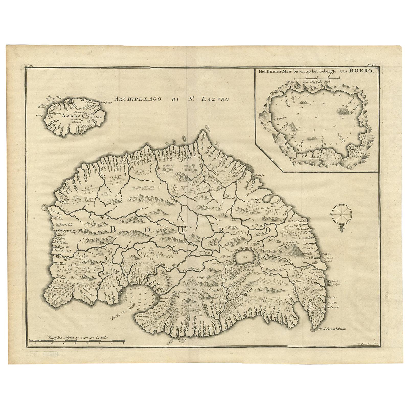
- Antique Map of Boero in Indonesia by Valentijn, 1726By F. ValentijnLocated in Langweer, NLAntique map titled 'Boero-Amblauw'. Detailed map of the Island Ambelau and Buru, Maluku Islands, Indonesia. With an inset of the lake on the Buru mountains. This print originates fro...Category
Antique Early 18th Century Dutch Maps
MaterialsPaper
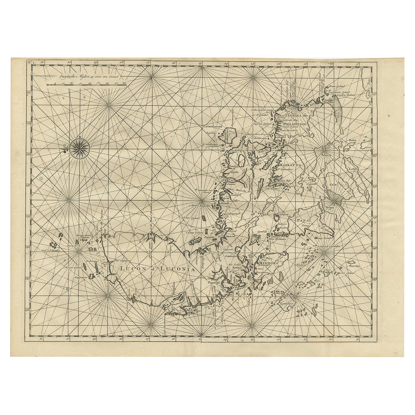
- Antique Map of Luzon of Luconia in the Philippines, 1726Located in Langweer, NLDescription: Antique map titled 'Lucon of Luconia'. Luzon is the largest and most populous island in the Philippines. It is ranked 15th largest in the world by land area. Located i...Category
Antique 1720s Maps
MaterialsPaper
- Antique Map of the Island of Borneo in Asia (Indonesia), 1726Located in Langweer, NLAntique map titled 'Kaart van het Eyland Borneo'. Early map of the island of Borneo. This map originates from 'Oud en Nieuw Oost-Indiën' by F. Valentijn. Artists and Engravers: Fran...Category
Antique 18th Century Maps
MaterialsPaper
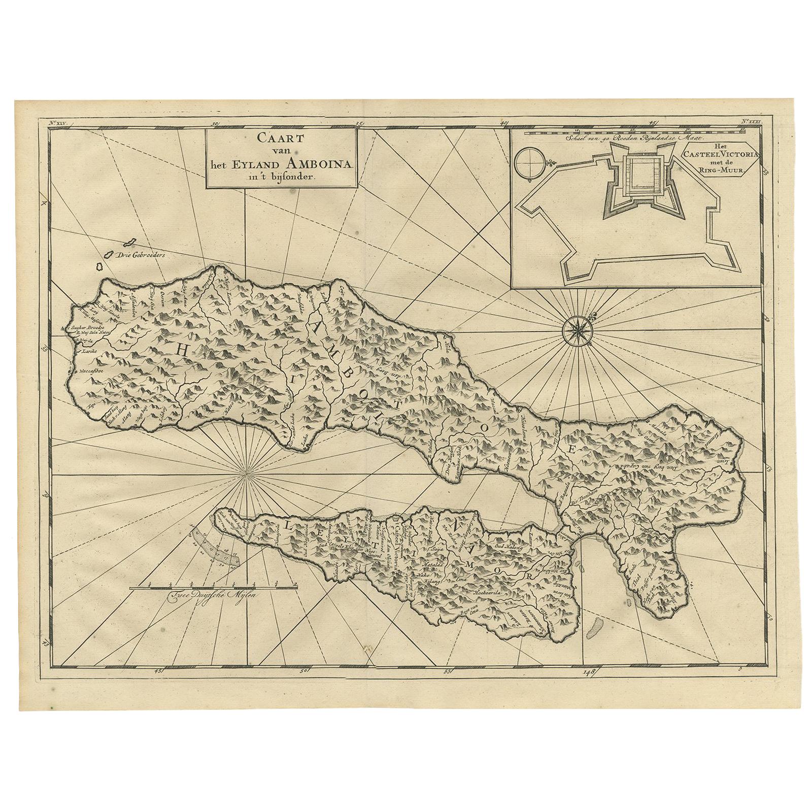
- Antique Map of Ambon Island by Valentijn, 1726By F. ValentijnLocated in Langweer, NLAntique map titled 'Caart van het Eyland Amboina in 't bijsonder'. Map of the Islands Ambon and Timor, one of the Moluccan Islands, Indonesia, with an inset of castle Victoria with t...Category
Antique Early 18th Century Dutch Maps
MaterialsPaper
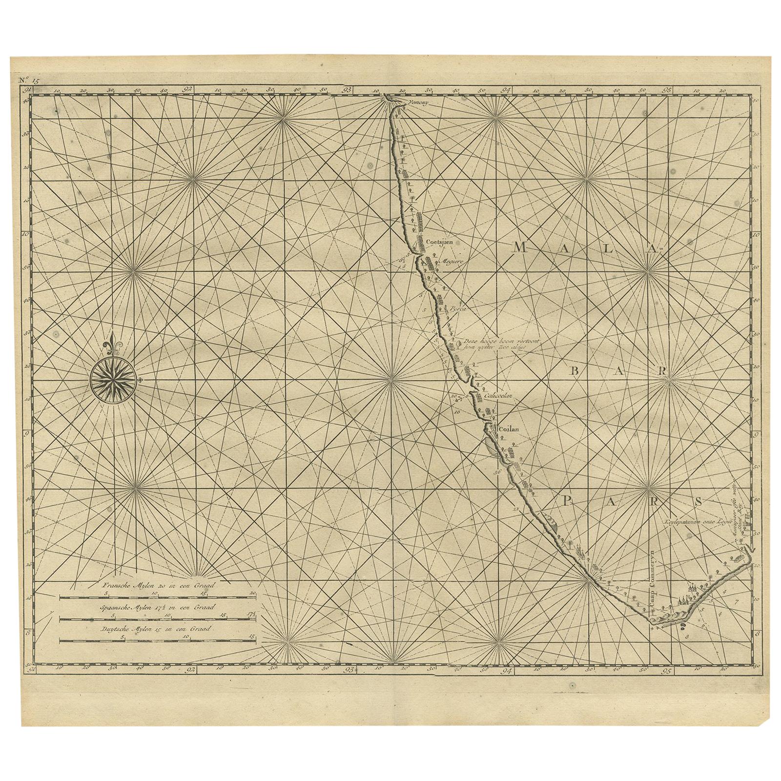
- Antique Map of Malabar Coast by Valentijn, 1726By F. ValentijnLocated in Langweer, NLUntitled sea chart of the coast of Malabar, India. This print originates from 'Oud en Nieuw Oost-Indiën' by F. Valentijn.Category
Antique Early 18th Century Dutch Maps
MaterialsPaper
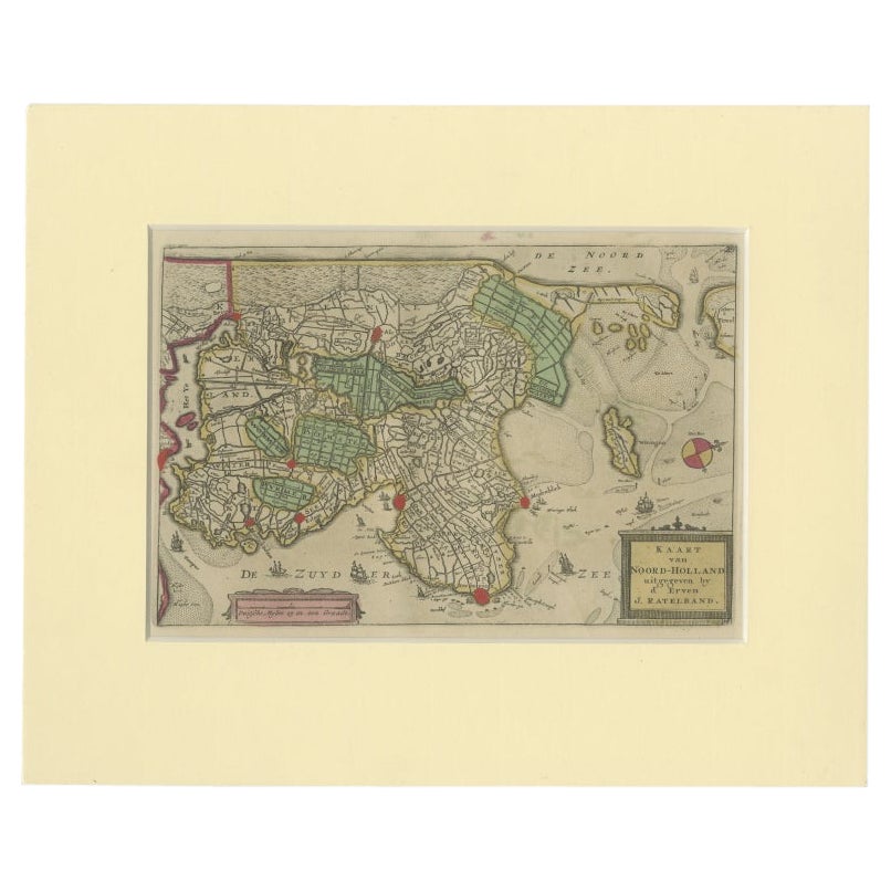
- Rare Antique Map of Noord-Holland, Province in The Netherlands, c.1750Located in Langweer, NLAntique map titled 'Kaart van Noord-Holland'. Map of the province of Noord-Holland, the Netherlands. Published circa 1750. Artists and Engravers: Published by 'de Erven van J. Ratelb...Category
Antique 18th Century Maps
MaterialsPaper


You May Also Like
- Antique Map of Principality of MonacoBy Antonio Vallardi EditoreLocated in Alessandria, PiemonteST/619 - "Old Geographical Atlas of Italy - Topographic map of ex-Principality of Monaco" - ediz Vallardi - Milano - A somewhat special edition ---Category
Antique Late 19th Century Italian Other Prints
MaterialsPaper
- Original Antique Map of Italy. C.1780Located in St Annes, LancashireGreat map of Italy Copper-plate engraving Published C.1780 Unframed.Category
Antique Early 1800s English Georgian Maps
MaterialsPaper

- Original Antique Map of Asia. C.1780Located in St Annes, LancashireGreat map of Asia Copper-plate engraving Published C.1780 Two small worm holes to right side of map Unframed.Category
Antique Early 1800s English Georgian Maps
MaterialsPaper

- Original Antique Map of India. C.1780Located in St Annes, LancashireGreat map of India Copper-plate engraving Published C.1780 Three small worm holes to right side of map and one bottom left corner Unframed.Category
Antique Early 1800s English Georgian Maps
MaterialsPaper

- Original Antique Map of Italy. Arrowsmith. 1820Located in St Annes, LancashireGreat map of Italy Drawn under the direction of Arrowsmith Copper-plate engraving Published by Longman, Hurst, Rees, Orme and Brown, 1820 Unframed.Category
Antique 1820s English Maps
MaterialsPaper
- Original Antique Map of Ireland- Kerry. C.1840Located in St Annes, LancashireGreat map of Kerry Steel engraving Drawn under the direction of A.Adlard Published by How and Parsons, C.1840 Unframed.Category
Antique 1840s English Maps
MaterialsPaper


