Items Similar to Rare Engravings of Council of War in Bantam and Javanese Local Traders, 1614

Want more images or videos?
Request additional images or videos from the seller
1 of 8
Rare Engravings of Council of War in Bantam and Javanese Local Traders, 1614
About the Item
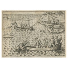
One leaf with an engraving on each site and text in old Dutch. One side shows the War Council of the locals in Bantam and the other side show some vegetables traders of Bantam.
Banten, also written as Bantam, is a port town near the western end of Java, Indonesia. It has a secure harbour at the mouth of Banten River, a navigable passage for light craft into the island's interior. The town is close to the Sunda Strait through which important ocean-going traffic passes between Java and Sumatra. Formerly Old Banten was the capital of a sultanate in the area, was strategically important and a major centre for trade. The English East India Company began to send ships to the East Indies around 1600 and established a permanent trading post at Bantam in 1603, as did the Dutch also. Aaron Baker (1610-1683) served for twenty years as President of Bantam, as is recorded on his mural monument in Dunchideock parish church, Devon. In the thirty years following 1603, the trading factories established by the English on the Coromandel Coast of India, such as those at Machilipatnam (estd. 1611) and Fort St. George (estd. 1639), reported to Bantam.
During the 17th century, the Portuguese and the Dutch fought for control of Bantam. Eventually, the fact that the Dutch found they could control their Batavia trading factory, established in 1611, more thoroughly than Bantam may have contributed to the decline of the English trading post. (Source: Wikipedia)
This leaf is from the rare Johan Isaac Pontanus & J. Hondius edition of 1614 - 'Historische beschrijvinghe der seer wijt beroemde coop-stadt Amsterdam'- which includes the text of the first voyage around the Cape to the East Indies (including a visit to Madagascar), the fight against the Portuguese on Bantam (West Java), description of Java, etc.
Creator: Anoniem / Anonymous(engraver / etcher), Lodewijcksz, Willem(copied after)
Period: 1614
Material: paper
Technique: copper engraving
Measurements sheet: 9.5 x 7 inch ( 24x18 cm)
Measurement engravings: 5.9 x 4.5 inch ( 15x11.5 cm ) each
The condition of the engravings is very good, Dutch text on verso of the leaf, but the paper is not strong. Water damage, but mostly outside the images. Study the image of the larger leaf carefully.
- Dimensions:Height: 7.09 in (18 cm)Width: 9.45 in (24 cm)Depth: 0 in (0.02 mm)
- Materials and Techniques:
- Period:Early 17th Century
- Date of Manufacture:1614
- Condition:
- Seller Location:Langweer, NL
- Reference Number:
About the Seller
5.0
Platinum Seller
These expertly vetted sellers are 1stDibs' most experienced sellers and are rated highest by our customers.
Established in 2009
1stDibs seller since 2017
1,938 sales on 1stDibs
Typical response time: <1 hour
- ShippingRetrieving quote...Ships From: Langweer, Netherlands
- Return PolicyA return for this item may be initiated within 14 days of delivery.
More From This SellerView All
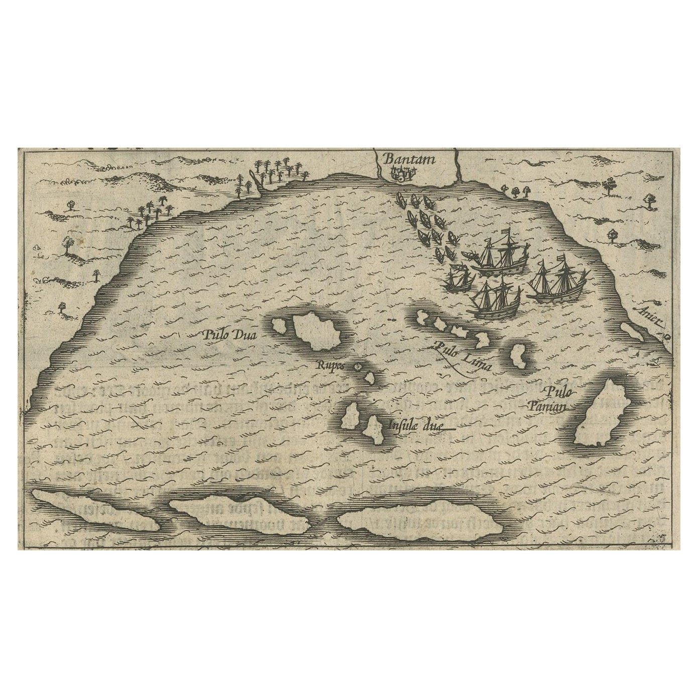
- Small Map of Bantam with Dutch Ships and an Engraving of Portugese, 1614Located in Langweer, NLTwo rare old miniature copper-engravings one one leaf. One showing the first arrival of the first Dutch in Indonesia, the so-called 'Houtman expedition' and on the reverse Portugese welcoming them with gifts. The First Dutch Expedition to Indonesia was an expedition that took place from 1595 to 1597. It was instrumental in the opening up of the Indonesian spice trade...Category
Antique Early 17th Century Maps
MaterialsPaper
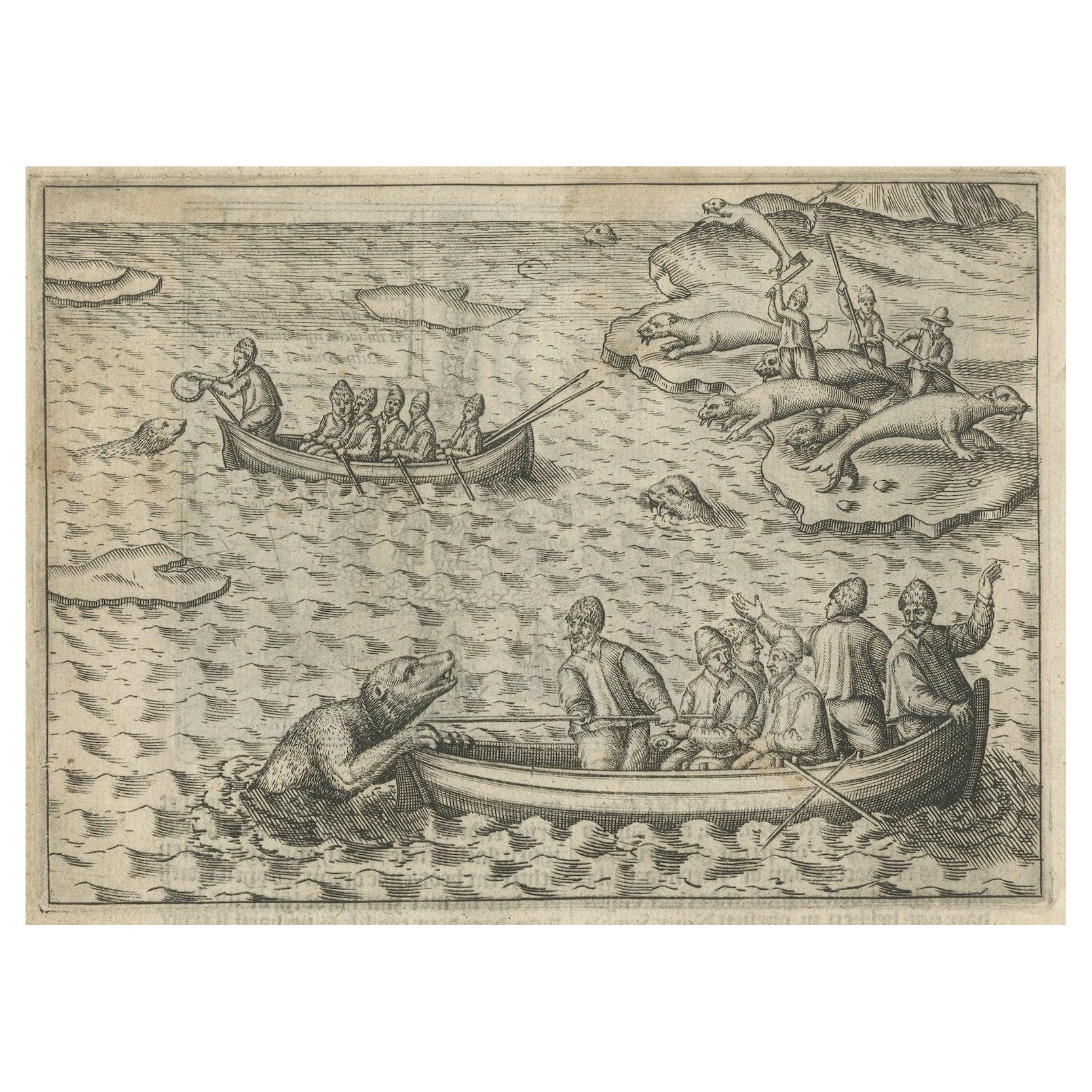
- Rare Map of Kildin Island in Russia Plus Engraving of Seal Hunting, 1614Located in Langweer, NLInsula Kilduyn. Orig. copper-engraving after details from J. H. van Linschoten's map taken from his account of the three expeditions undertaken by Willem Barents in 1594, in an attem...Category
Antique Early 17th Century Maps
MaterialsPaper
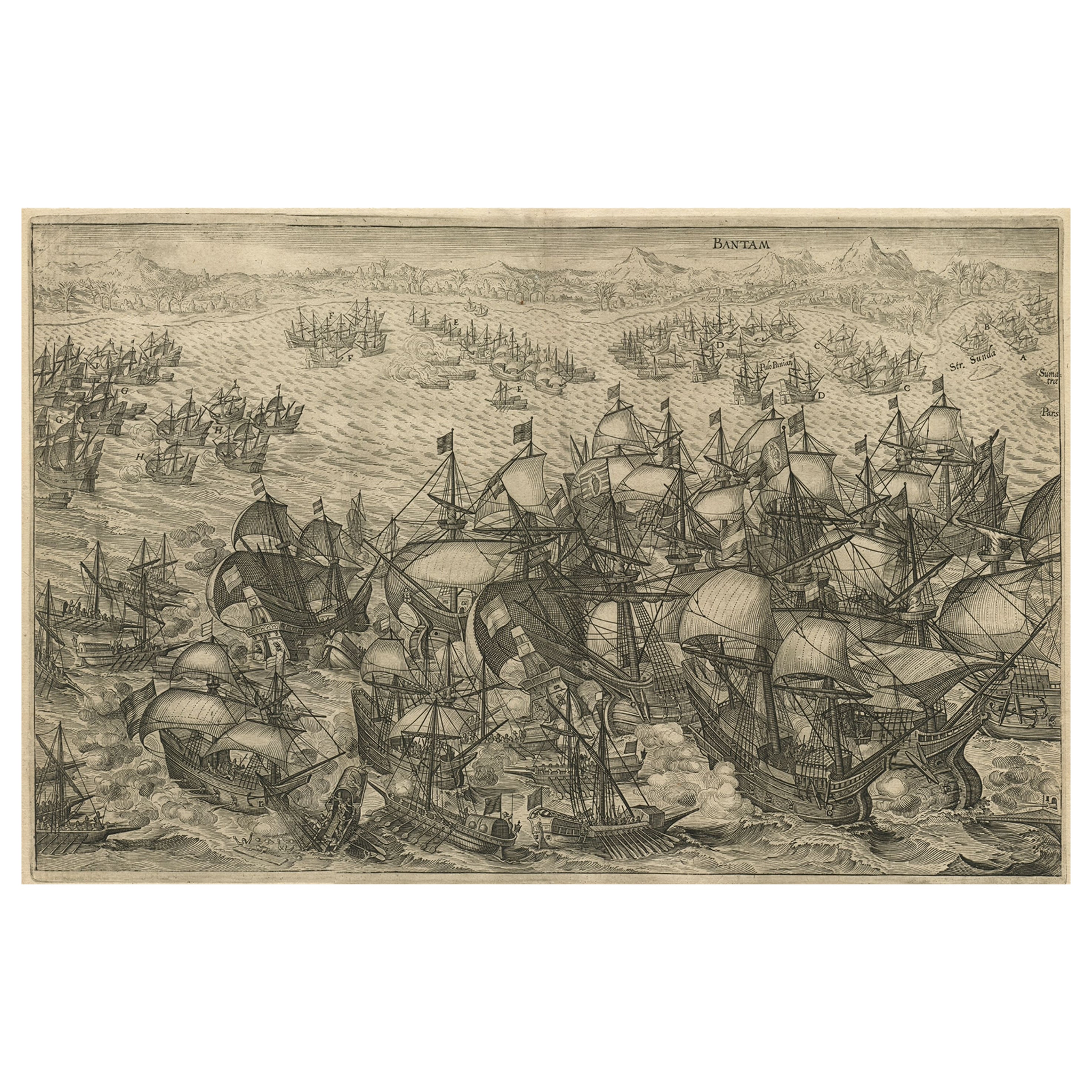
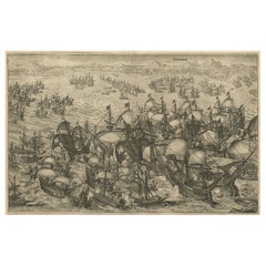
- Engraving of Dutch Attacking the Portuguese Fleet off Bantam, Indonesia, 1644Located in Langweer, NLAntique print titled 'Bantam'. Copper engraving of the Dutch attack on the Portuguese fleet off Bantam in 1601 depicted as the victory of Admiral Wolfert Harmensz and his 5 ships over 30 Portuguese ships. The ships in the battle include the Sultan of Bantam’s war galleys (ghali); ocean-going craft with sails, oars and a prow battering ram built according to Mediterranean standards learnt from Portuguese renegades and Turkish shipwrights. They were built to allow them to shoot the large cannon...Category
Antique 1640s Arms, Armor and Weapons
MaterialsPaper
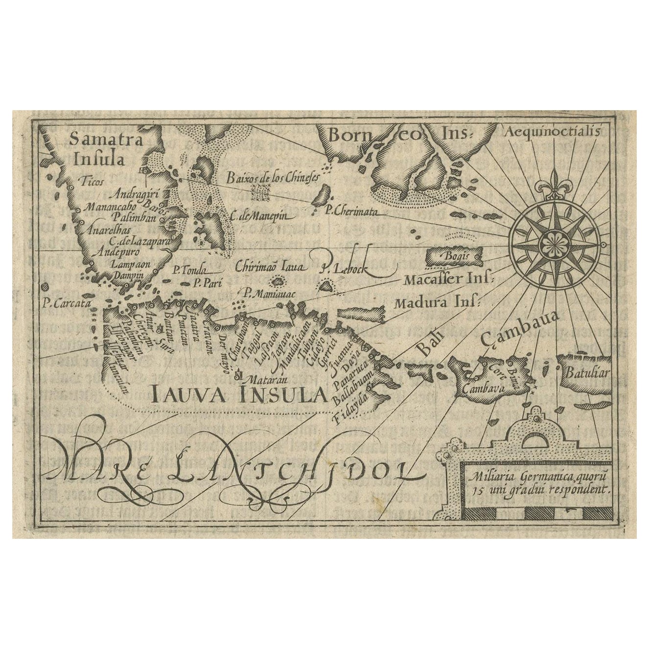
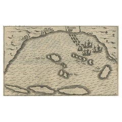
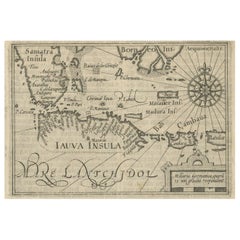
- Rare Small Map of Sumatra, Java, Borneo, Macassar, Madura, Bali, 1614Located in Langweer, NLOne of the first maps of the Indonesia islands of Java, Bali, Sumbawa etc. in early days of the Dutch Indies. Also showing Banten, Jakarta (Jacatra), Indr...Category
Antique Early 17th Century Maps
MaterialsPaper
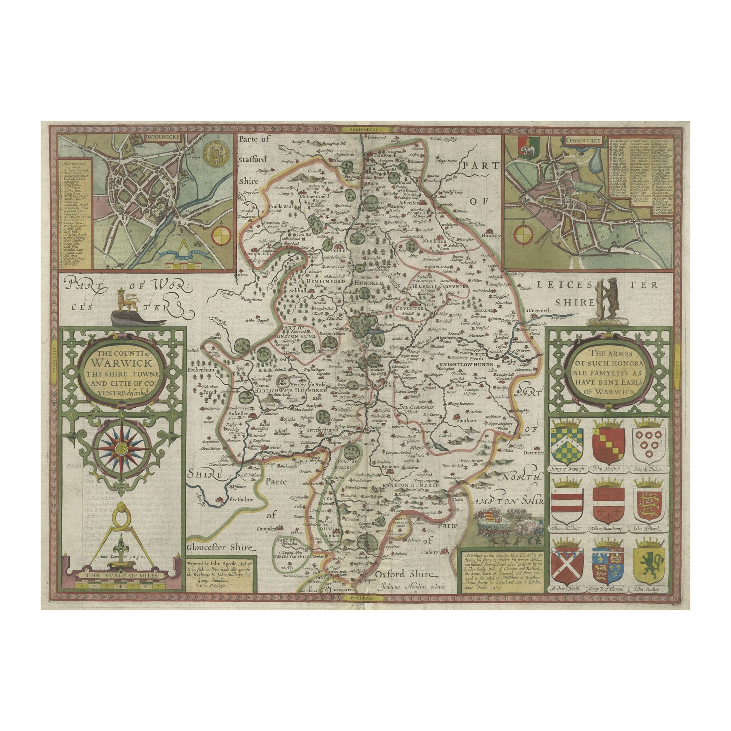
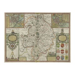
- Antique Map of Warwickshire in England by Speed, c.1614Located in Langweer, NLAntique map titled 'The Counti of Warwick the Shire Towne and Citie of Coventre described'. Map of Warwickshire, England. Includes inset town plans of Warwic...Category
Antique 17th Century Maps
MaterialsPaper
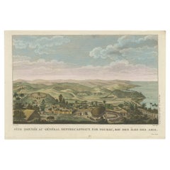
- Beautiful and Rare Original Antique Engraving of a Village in Tonga, 1817Located in Langweer, NLFete donnee au General Dentrecasteaux par Toubau, Roi des Iles des Amis Original antique engraving showing the party given to General Dentrecasteaux by Toubau, King of the Friendl...Category
Antique 1810s Prints
MaterialsPaper
You May Also Like
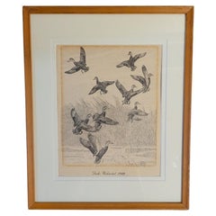
- Rare Lynn Bogue Hunt Engraving of Ducks Unlimited, 1940By Lynn Bogue HuntLocated in Dallas, TXPresenting a Rare Lynn Bogue Hunt engraving of ducks unlimited 1940. This piece cam from a wealthy estate in Dallas, TX with the mansion being built...Category
Mid-20th Century American Sporting Art Prints
MaterialsPaper
- Civil War Panorama of the Seat of War by John Bachmann, Antique Print circa 1864Located in Colorado Springs, COPanorama of the seat of war. Bird's-eye View of Virginia, Maryland, Delaware and the District of Columbia. This third state of this fascinating bird's eye view of the northernmost p...Category
Antique 1860s American Maps
MaterialsPaper
- 1876 "Gettysburg, The Repulse of Longstreet's Assault." EngravingLocated in Colorado Springs, COPresented here is an 1876 engraving of John B. Bachelder and James Walker’s Gettysburg. The Repulse of Longstreet’s Assault. The engraved scene depicts the decisive battle on the final day of the Battle of Gettysburg. Researched by the photographer and topographer John B. Bachelder and painted by James Walker, the original painting was created in 1870. This detailed engraving was done by H. B. Hall Jr. and published by James Drummond Ball. Otherwise called Pickett’s Charge, the battle occurred on July 3, 1863. Pickett’s corp commander, Lieutenant General James Longstreet was placed in charge of the attack despite his hesitations. Longstreet’s central role led to the title of the work, Repulse of Longstreet’s Assault. In an attempt to gain control of an important supply route, nine Confederate brigades charged across three-quarters of a mile of open ground against cannon fire to take Cemetery Ridge from the defending Union Army. Despite their overwhelming numbers, the Confederate forces were repelled with considerable casualties marking not only a decisive victory for the Union, but also the beginning of the slow defeat of Lee’s Army. The furthest the charging forces advanced before being repulsed would forever be known as the “High Water Mark of the Confederacy.” The Confederate army never recovered from the losses at Gettysburg and it effectively ended Lee’s campaign into Pennsylvania. The engraving gives the perspective from the Union rear, one that encompasses most of the battlefield, from Big Round Top on the left to the northern reaches of Cemetery Ridge on the right. The Confederate lines at Seminary Ridge are in the far distance, partially obscured by bursting shells. The image centers on the main Confederate assault, in the vicinity of what today are known as "The Copse" and "The Bloody Angle." The composition has elemen...Category
Antique 1870s American Prints
MaterialsPaper
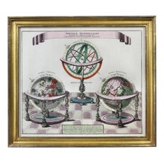
- Framed Engraving By Matthaus Seutter Of Sphaerae ArtificialesLocated in Essex, MACartographer from Germany 1678-1757. Hand colored. Gilt wood frame. Estate of William Hodgins.Category
Antique Early 1700s German Prints
MaterialsPaper
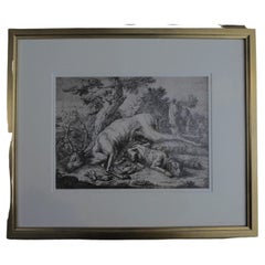
- Framed Johann Elias Ridinger Engraving, 18th Stag EngravingLocated in Perth, GBFine 18th century engraving of a stag, after the hunt, with a magnificient dog at rest, in a country scene, beautifully depicted.Category
Antique 18th Century Prints
MaterialsPaper
- “The Restaurant of the House of Representatives” Engraving by Harper's WeeklyLocated in Colorado Springs, COThis original wood engraving is titled “The Restaurant of the House of Representatives, Washington, DC.” It was published as a double-page image, in the August 12, 1893 issue of the famous 19th century newspaper Harper’s Weekly. The print was illustrated by Charles Stanley Reinhardt. The House Restaurant, a unique part of life in the Capitol, has been in the same location since the 1857 Capitol Expansion. Congressional members’ busy work schedule made the availability of food on site a necessity. But the restaurant also served as an informal meeting spot for members to continue conversations and deal making. This 1893 print illustrates the convivial atmosphere. Details including elegantly dressed tables...Category
Antique 1890s American Prints
MaterialsPaper


Recently Viewed
View AllMore Ways To Browse
Rare Engravings
Council Furniture
English Early 17th Century Furniture
Antique Church Collectibles
Antique Trade Show
Ship Map
George Map
India Engraving
Early Baker Furniture
Ship In Ocean
Council Craft Furniture
Portugal 17th
Antique War Maps
Used Furniture Devon
Antique Trader
The Antique Trader
Aarons Used Furniture
Java Dutch