Items Similar to Spectacular Large Map of Upper and Lower Austria between Passau and Wien, c.1700


Want more images or videos?
Request additional images or videos from the seller
1 of 5
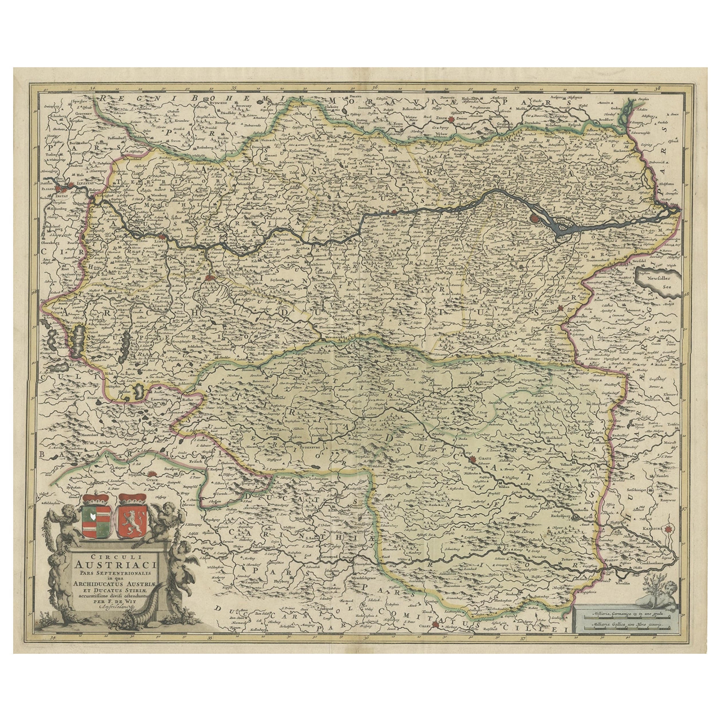
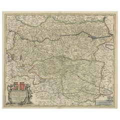
Spectacular Large Map of Upper and Lower Austria between Passau and Wien, c.1700
About the Item
Antique map titled 'Austriae Archiducatus pars superior in omnes ejusdem (..).'
Spectacular large map of Upper and Lower Austria between Passau and Wien with figurative cartouche and armorial vignette. Printed on two sheets and joined. Published by Pieter Schenk junior from the plate by Nicolaas Visscher. With 2 beautiful cartouches. Source unknown, to be determined.
Artists and Engravers: Made by 'Nicolaes Visscher' after 'Pieter Schenk'. For nearly a century the members of the Visscher family were important art dealers and map publishers in Amsterdam. The founder of the business, C. J. Visscher, had premises near to those of Pieter van den Keere and Jodocus Hondius whose pupil he may have been. From about 1620 he designed a number of individual maps, including one of the British Isles, but his first atlas consisted of maps printed from plates bought from van den Keere and issued as they stood with some additions of his own, including historical scenes of battles and sieges for which he had a high reputation. Some maps bear the latinized form of the family name: Piscator. After Visscher's death his son and grandson, both of the same name, issued a considerable number of atlases, constantly revised and brought up to date but most of them lacking an index and with varying contents. The widow of Nicholaes Visscher II carried on the business until it finally passed into the hands of Pieter Schenk. Pieter Schenk / Petrus Schenck ( 1660-1718/19) was born in Germany, but settled in Amsterdam where he first became a pupil of Gerard Valck, the engraver. In 1687 he married Valck's sister and thereafter the Schenk and Valck families were active over a long period with a wide range of interests as print sellers, publishers of books, maps, topographical and architectural drawings and globes. Although they produced some original maps, most of their atlases consisted of printings from revised and re-worked plates originally by Jansson, the Visschers, the Sansons and others. Willebrordus vander Burght was a 17th century Dutch cartographer.
Condition: Good, given age. Left side 2 soft vertical creases. Left fold with minimal tear bottom edge. A few small spots in the margins. Original folds. General age-related toning and/or occasional minor defects from handling. Please study image carefully.
- Dimensions:Height: 21.15 in (53.7 cm)Width: 35.63 in (90.5 cm)Depth: 0 in (0.02 mm)
- Materials and Techniques:
- Period:1700-1709
- Date of Manufacture:circa 1700
- Condition:Wear consistent with age and use. Condition: Good, given age. Left side 2 soft vertical creases. Left fold with minimal tear bottom edge. A few small spots in the margins. Original folds. General age-related toning and/or occasional minor defects from handling. Please study image.
- Seller Location:Langweer, NL
- Reference Number:
About the Seller
5.0
Platinum Seller
These expertly vetted sellers are 1stDibs' most experienced sellers and are rated highest by our customers.
Established in 2009
1stDibs seller since 2017
1,948 sales on 1stDibs
Typical response time: <1 hour
- ShippingRetrieving quote...Ships From: Langweer, Netherlands
- Return PolicyA return for this item may be initiated within 14 days of delivery.
More From This SellerView All
- Antique Map of the Upper and Lower Rhine by Cary '1811'By John CaryLocated in Langweer, NLAntique map titled 'A New Map of the Circles of the Upper and Lower Rhine'. Antique map covering an area from Westphalia and Lower Saxony in the north to France and Swabia in the south.Category
Antique Early 19th Century Maps
MaterialsPaper
- Antique Map of Austria, Centered Around the Danube from Passau to Vienna, C.1690Located in Langweer, NLAntique map of Austria titled 'Circuli Austriaci pars septentrionalis in quia archiducatus Austriae et Ducatus Stiriae accuratissime divisi ostenduntur per F. de Wit'. Detailed m...Category
Antique 1690s Maps
MaterialsPaper
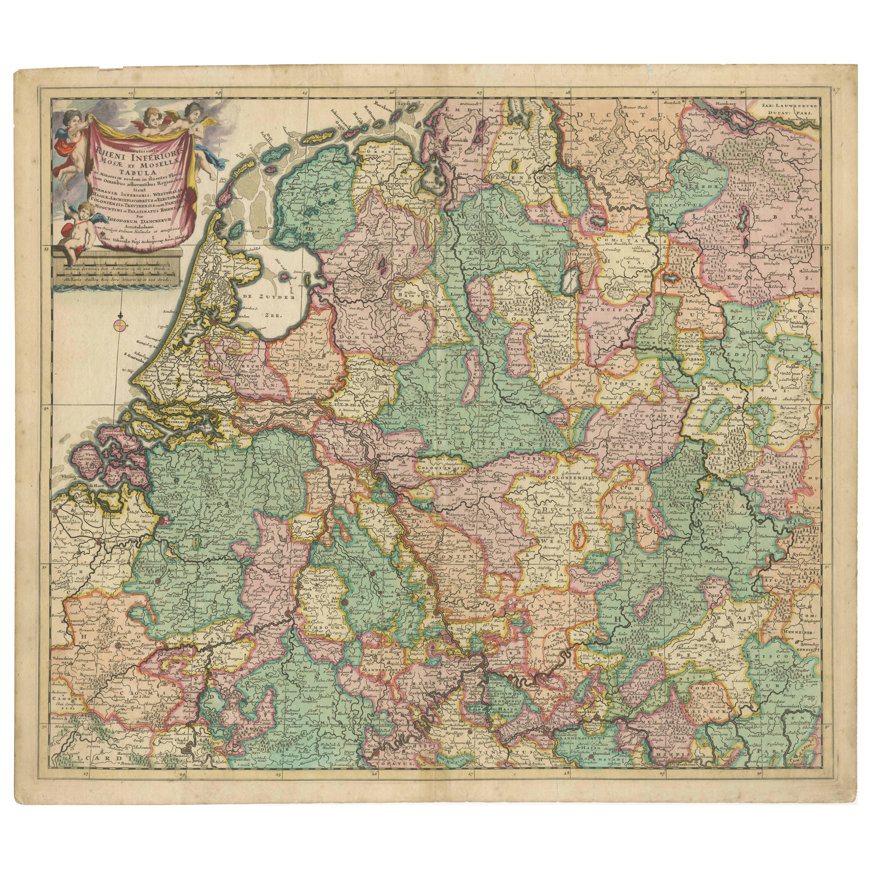
- Engraved Map of the Lower Rhine, Meuse, Moselle, Scheldt, Ems & Weser, c.1700Located in Langweer, NLBeautiful original hand-colored antique map of a large part of Western Europe. Title: Accuratissima Rheni Inferioris, Mosae et Mosellae Tabula. Maker: T. Danckerts. Amsterdam, ...Category
Antique Early 1700s Maps
MaterialsPaper
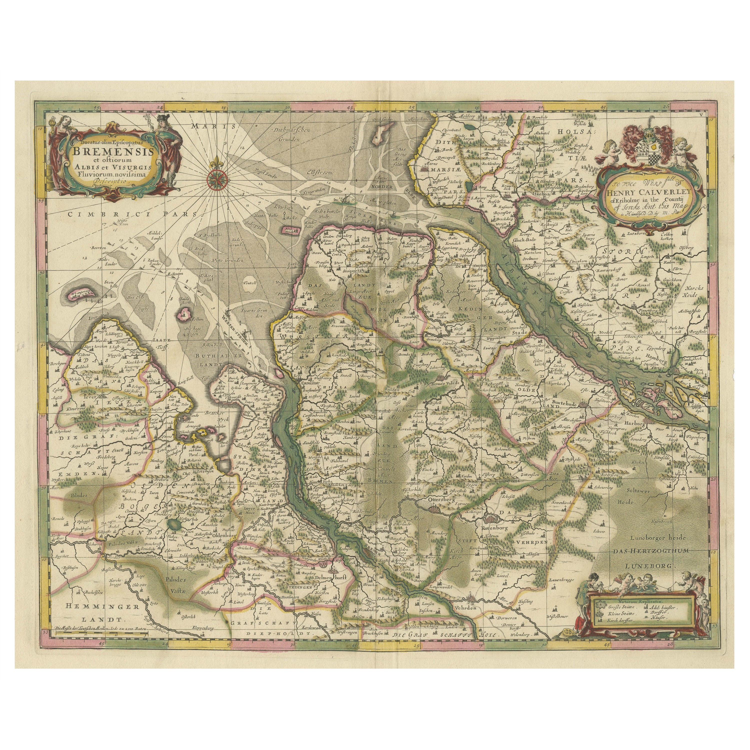
- Original Antique Map of the Area of Bremen and Lower SaxonyBy Johannes JanssoniusLocated in Langweer, NLAntique map titled 'Ducatus olim Episcopatus Bremensis et ostiorum Albis et Visurgis Fluviorum novissima Descriptio'. Original old map of the area of ??Bremen and Lower Saxony. Uncom...Category
Antique Mid-17th Century Maps
MaterialsPaper
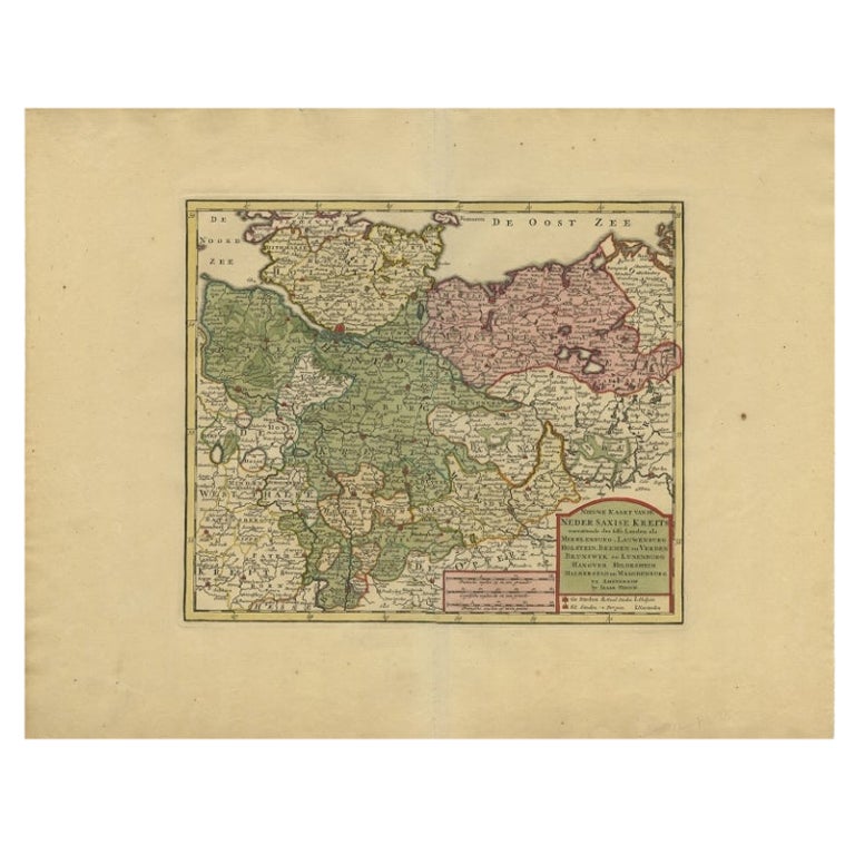
- Antique Map of Lower Saxony in Germany, c.1740Located in Langweer, NLAntique map titled 'Nieuwe Kaart van de Neder Saxise Kreits (..).' Attractive detailed map showing Lower Saxony, Germany, including Mekelenburg, Lauwenburg, Holstein, Bremen, Verden ...Category
Antique 18th Century Maps
MaterialsPaper
- Antique Map of Lower Saxony by Clouet, 1787Located in Langweer, NLAntique map titled 'Basse Saxe'. Antique map of Lower Saxony, Germany. Originates from 'Geographie moderne avec une introduction' by J.B.L. Clouet.Category
Antique Late 18th Century Maps
MaterialsPaper


You May Also Like
- "San Francisco, Upper California” 1851 Antique Map of San FranciscoLocated in Colorado Springs, COThis is a pictorial lettersheet view of the city and harbor of San Francisco. This lithograph was printed on grey wove paper, across a double sheet, by famed lithographers Britton & ...Category
Antique 1850s American Prints
MaterialsPaper
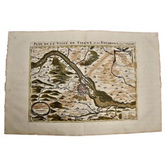
- Vienna, Austria: A Large 17th Century Hand-Colored Map by Sanson and JaillotBy Nicolas SansonLocated in Alamo, CAThis large 17th century hand-colored map of Vienna, Austria and the surrounding countryside and villages entitled "Plan de la Ville de Vienne en Austrich...Category
Antique 1690s French Maps
MaterialsPaper
- Large Antique 1859 Map of North AmericaLocated in Sag Harbor, NYThis Map was made by Augustus Mitchell in 1859 It is in amazing condition for being 163 years old. This price is for the rolled up easy to ship version of this piece. I will be Frami...Category
Antique Mid-19th Century American Maps
MaterialsCanvas, Paper

- Hand Colored 18th Century Homann Map of Austria Including Vienna and the DanubeBy Johann Baptist HomannLocated in Alamo, CA"Archiducatus Austriae inferioris" is a hand colored map of Austria created by Johann Baptist Homann (1663-1724) and published in Nuremberg, Germany in 1728 shortly after his death. ...Category
Antique Early 18th Century German Maps
MaterialsPaper
- Portugal: A Large 17th Century Hand-colored Map by Sanson and JaillotBy Nicolas SansonLocated in Alamo, CAThis large hand-colored map entitled "Le Royaume de Portugal et des Algarves Divisee en see Archeveches, Eveches et Territoires Par le Sr Sanson" was originally created by Nicholas S...Category
Antique 1690s French Maps
MaterialsPaper
- Antique Map of Principality of MonacoBy Antonio Vallardi EditoreLocated in Alessandria, PiemonteST/619 - "Old Geographical Atlas of Italy - Topographic map of ex-Principality of Monaco" - ediz Vallardi - Milano - A somewhat special edition ---Category
Antique Late 19th Century Italian Other Prints
MaterialsPaper


Recently Viewed
View AllMore Ways To Browse
1700 Antique Furniture
Antique Other Antiques Art Collectables
Austrian Dealers
Topographical Map
Austrian And German Antique Furniture
Up Junior
Antique Maps And Globes
Antique Globes And Maps
Circa 1620
Siege Antique
Armorial Plate
Seller Austria
Antique Topographic Maps
Austrian 17th
Dutch Battle
17th Map Large
Map Austria
Map Of Austria