Items Similar to 17th Century Lithograph Framed Map of Spain


Want more images or videos?
Request additional images or videos from the seller
1 of 7
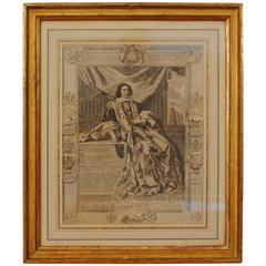
17th Century Lithograph Framed Map of Spain
About the Item
In giltwood frame, dated 1652.
- Dimensions:Height: 20.5 in (52.07 cm)Width: 25.5 in (64.77 cm)Depth: 0.5 in (1.27 cm)
- Style:Baroque (Of the Period)
- Materials and Techniques:
- Place of Origin:
- Period:
- Date of Manufacture:circa 1652 and Later Frame
- Condition:Wear consistent with age and use.
- Seller Location:Atlanta, GA
- Reference Number:
About the Seller
5.0
Vetted Seller
These experienced sellers undergo a comprehensive evaluation by our team of in-house experts.
Established in 1993
1stDibs seller since 2007
258 sales on 1stDibs
Typical response time: 1 hour
- ShippingRetrieving quote...Ships From: Atlanta, GA
- Return PolicyThis item cannot be returned.
More From This SellerView All
- Mid-18th Century Engraving in a Mid-19th Century Giltwood FrameLocated in Atlanta, GAdisplaying a king or nobleman seated on a throneCategory
Antique Early 18th Century French Louis XIV Prints
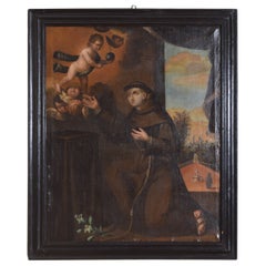
- Spanish or Pourtuguse Large Oil on Canvas, "Saint Anthony", Mid-17th CenturyLocated in Atlanta, GAOil on canvas depicting Saint Anthony in a garden being visited by Angelic Cherubs with a courtyard and fountain and mysterious figure in the background, the ever present Lily flower in the foreground. In a period ebonized wood frame. Anthony of Padua (Italian: Antonio di Padova) or Anthony of Lisbon (Portuguese: António/Antônio de Lisboa; born Fernando Martins de Bulhões; 15 August 1195 – 13 June 1231) was a Portuguese Catholic priest...Category
Antique Mid-17th Century European Baroque Paintings
MaterialsPaint
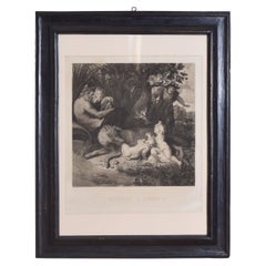
- Italian Large Engraving of Romulus & Remus, Ebonized Frame, 2nd Half 19th CenLocated in Atlanta, GAIn Roman mythology, Romulus and Remus are twin brothers whose story tells of the events that led to the founding of the city of Rome and the Roman Kingdom by Romulus, following his f...Category
Antique 19th Century Italian Prints
MaterialsPaper
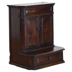
- Italian, Tuscan 17th Century Walnut Prie-dieu 'Inginocchiatoio'Located in Atlanta, GAAn important, grand scale, and wonderfully aged example of an Italian inginocchiatoio. The piece originally meant for storing reliquaries, books, and kneeling in prayer has a rectang...Category
Antique 17th Century Italian Baroque Cabinets
MaterialsWalnut
- Italian Baroque Period Paneled Walnut Cassone, 17th centuryLocated in Atlanta, GAHaving a rectangular hinged top with a raised Baroque panel above a conforming case with a continuous molded band, the plinth-form base atop bracket feetCategory
Antique Mid-17th Century Italian Baroque Blanket Chests
MaterialsWalnut
- Italian Baroque Walnut Guilloche Carved Mirror, 17th/18th CenturyLocated in Atlanta, GAThe rectangular frame with guilloche carved moldings, the center molding projecting outward, retaining antique beveled mirrorplate.Category
Antique Early 1700s Italian Baroque Wall Mirrors
MaterialsWalnut
You May Also Like
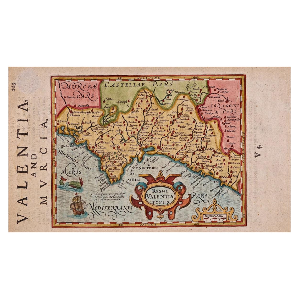
- 17th Century Hand-Colored Map of Valencia and Murcia, Spain by Mercator/HondiusBy Gerard MercatorLocated in Alamo, CAA 17th century hand-colored map entitled "Regni Valentiae Typus, Valentia and Murcia" by Gerard Mercator and Joducus Hondius, published in Amsterdam in 1635 in 'Cosmographicall Descr...Category
Antique Mid-17th Century Dutch Maps
MaterialsPaper
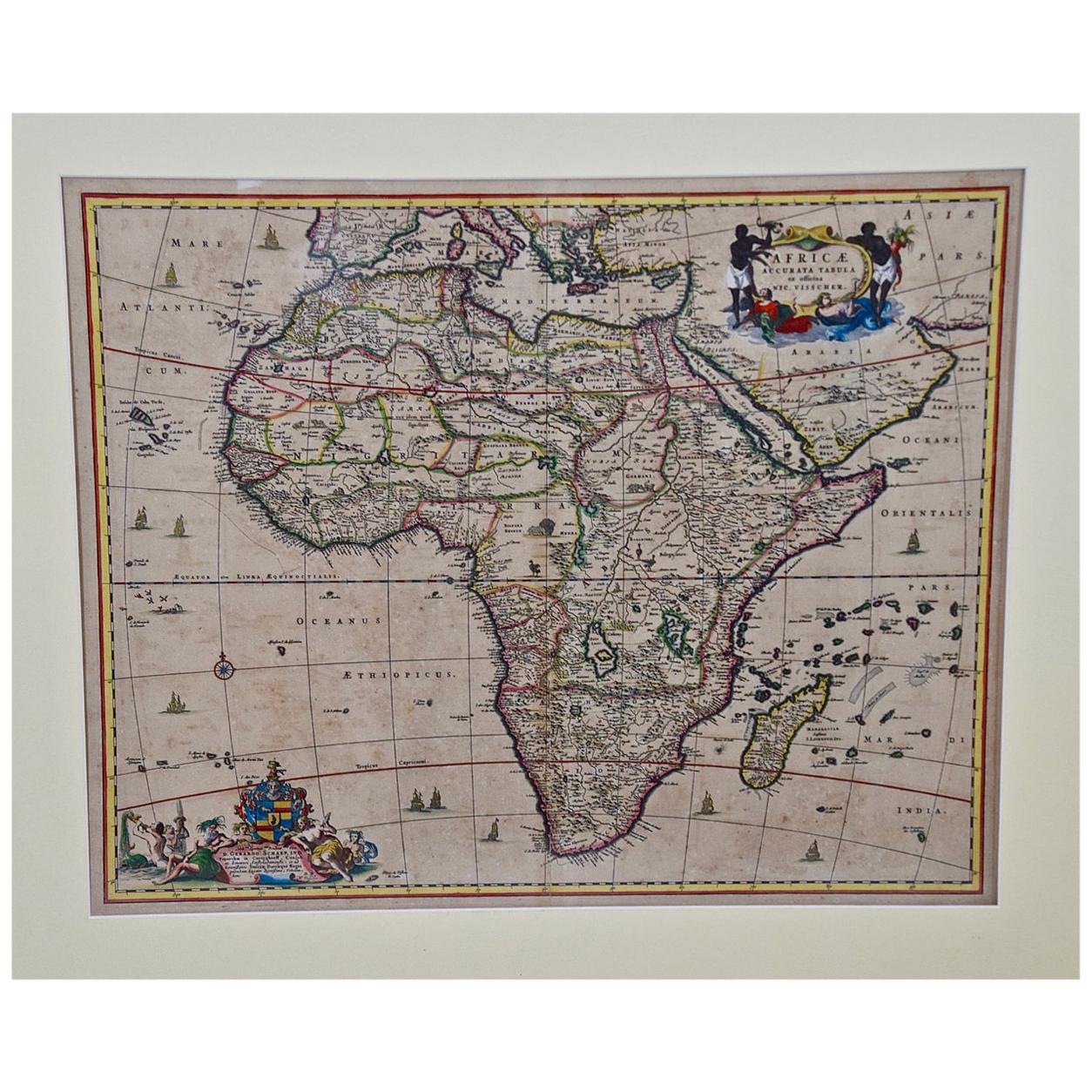
- "Africae Accurata", a Hand-Colored 17th Century Map of Africa by VisscherBy Nicolaes Visscher IILocated in Alamo, CAAn 18th century hand-colored map of Africa entitled "Africae Accurata Tabula ex officina" by Nicolaes Visscher, published in Amsterdam in 1680. This beautiful, colorful and detailed map is embellished by eleven sailing ships, a whale, flying fish and multiple land animals. It includes the Mediterranean Sea and adjacent portions of Portugal, Spain, Italy, Greece and Asia Minor. The map perpetuates several long-standing errors, including the origin of the Nile River from two imaginary lakes in southern Africa, which are shown adjacent to the imaginary Lunae Montes (Mountains of the Moon...Category
Antique Late 17th Century Dutch Maps
MaterialsPaper
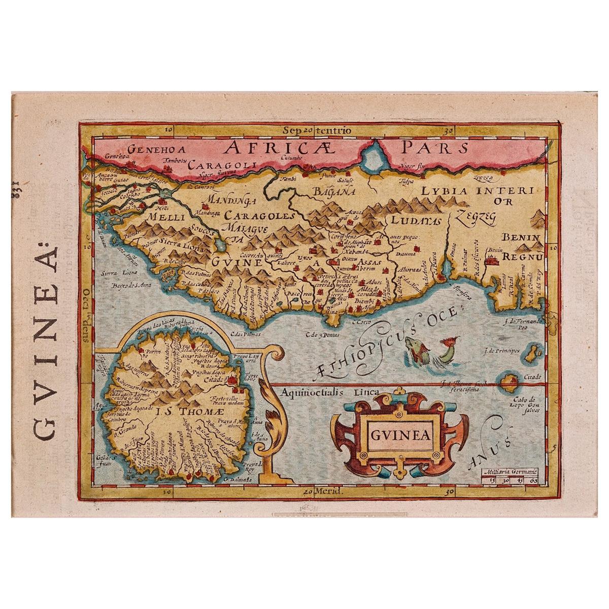
- 17th Century Hand-Colored Map of West Africa by Mercator/HondiusLocated in Alamo, CAA 17th century hand-colored map entitled "Guineae Nova Descriptio" by Gerard Mercator and Jodocus Hondius, published in their 'Atlas Minor' in Amsterdam in 1635. It is focused on the...Category
Antique Mid-17th Century Dutch Maps
MaterialsPaper
- 17th Century Map of Denmark by French Cartographer Sanson, Dated 1658By Nicolas SansonLocated in Copenhagen, K17th century map of Denmark by French cartographer Sanson. Nicolas Sanson (20 December 1600-7 July 1667) was a French cartographer, termed by some the creator of French geography an...Category
Antique 17th Century French Maps
MaterialsPaper
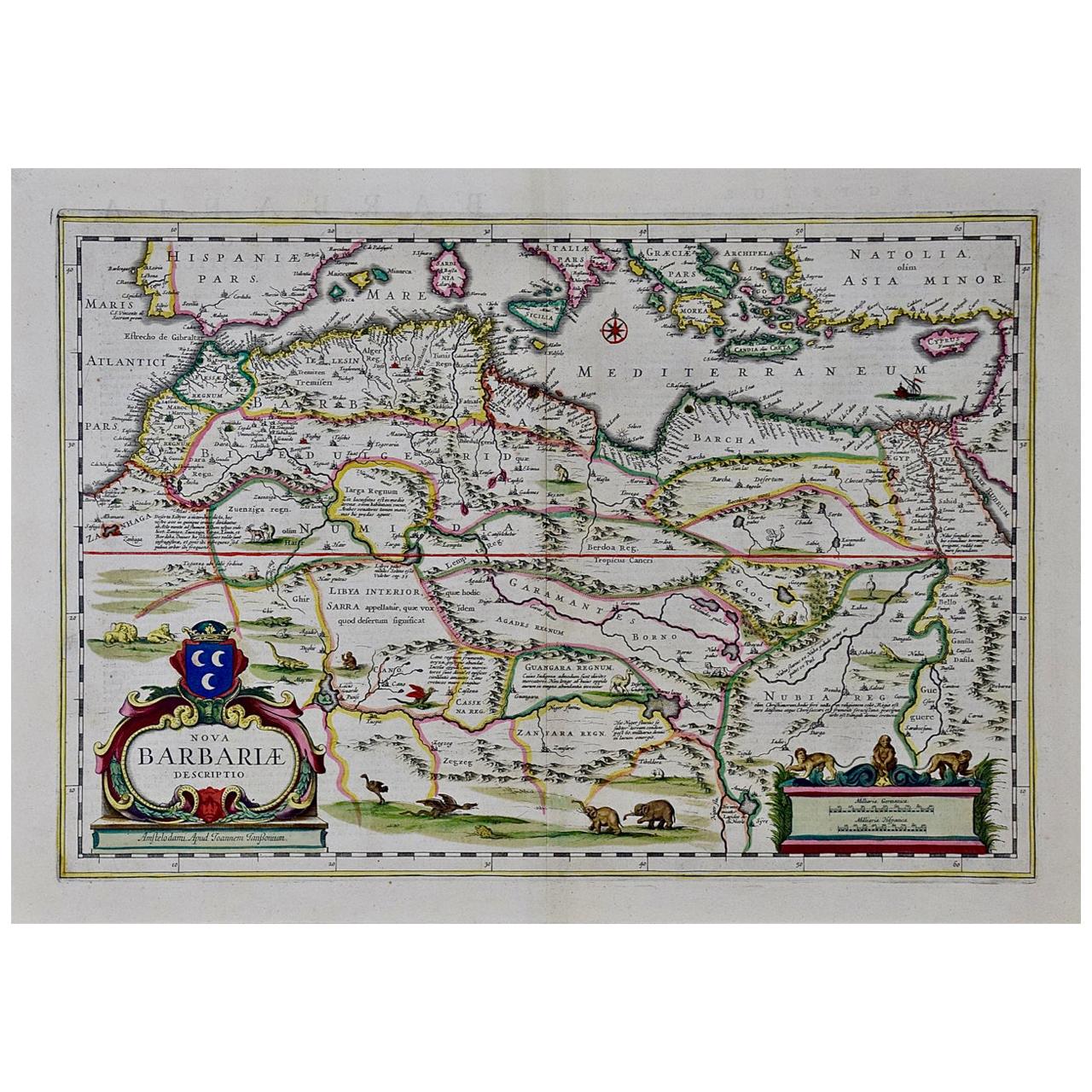
- "Nova Barbariae Descriptio", a 17th Century Hand-Colored Map of North AfricaBy Johannes JanssoniusLocated in Alamo, CAThis original attractive 17th century hand-colored map of North Africa entitled "Nova Barbariae Descriptio" by Johannes Janssonius was published in Paris in 1635. It includes the Med...Category
Antique Mid-17th Century Dutch Maps
MaterialsPaper
- "Africa Vetus": a 17th Century Hand-Colored Map by SansonBy Nicolas SansonLocated in Alamo, CAThis original hand-colored copperplate engraved map of Africa entitled "Africa Vetus, Nicolai Sanson Christianiss Galliar Regis Geographi" was originally created by Nicholas Sanson d...Category
Antique Late 17th Century French Maps
MaterialsPaper


Recently Viewed
View AllMore Ways To Browse
Dated 17th Century Furniture
17th Century Spanish Baroque
Spanish Baroque Frame
Giltwood Framed Print
Botanical Print Set
Antique Prints India
Sets Of Botanical Prints
Set Of Botanic Prints
Set Of Botanical Prints
Antique Colored Engravings
Antique Paper Ornaments
Set Framed Engraved
19th Century Botanical Frame
Original Antique Bird Print
Pair Antique Prints
Histoire Naturelle
Metal Bird Houses
Racinet Antique Print