Items Similar to Antique Chart of Celestial and Scientific Models by Lapie, 1842


Want more images or videos?
Request additional images or videos from the seller
1 of 5
Antique Chart of Celestial and Scientific Models by Lapie, 1842
About the Item
Antique print titled 'Systèmes Planétaires'. Chart of various celestial and scientific models. Includes an armillary sphere and various models of the universe, the season, eclipses, a Copernican, Tycho-Brahe and Ptolomaic model of the solar system and other models. This print originates from 'Atlas universel de géographie ancienne et moderne (..)' by Pierre M. Lapie and Alexandre E. Lapie. Pierre M. Lapie was a French cartographer and engraver. He was the father of cartographer Alexandre Emile Lapie.
- Dimensions:Height: 19.89 in (50.5 cm)Width: 26.78 in (68 cm)Depth: 0.02 in (0.5 mm)
- Materials and Techniques:
- Period:
- Date of Manufacture:1842
- Condition:General age-related toning, original folding line. Blank verso, please study images carefully.
- Seller Location:Langweer, NL
- Reference Number:
About the Seller
5.0
Platinum Seller
These expertly vetted sellers are 1stDibs' most experienced sellers and are rated highest by our customers.
Established in 2009
1stDibs seller since 2017
1,928 sales on 1stDibs
Typical response time: <1 hour
- ShippingRetrieving quote...Ships From: Langweer, Netherlands
- Return PolicyA return for this item may be initiated within 14 days of delivery.
More From This SellerView All
- Antique Map of Switzerland by Lapie, 1842Located in Langweer, NLAntique map titled 'Carte de la Suisse ou Helvetie'. Map of Switzerland. This map originates from 'Atlas universel de géographie ancienne et moderne...Category
Antique Mid-19th Century Maps
MaterialsPaper
- Antique Map of Italy by Lapie, 1842Located in Langweer, NLAntique map titled 'Carte de l'Italie Ancienne'. Map of Italy. This map originates from 'Atlas universel de géographie ancienne et moderne (..)' by Pierre...Category
Antique Mid-19th Century Maps
MaterialsPaper
- Antique Map of Scandinavia by Lapie, 1842Located in Langweer, NLAntique map titled 'Carte de la Scandinavie comprenant les Royaumes de Suède de Norwege et de Danemark'. Map of Scandinavia including Sweden, Norway and Denma...Category
Antique Mid-19th Century Maps
MaterialsPaper
- Antique Map of Europe by Lapie, 1842Located in Langweer, NLAntique map titled 'Carte de l'Europe'. Map of Europe. This map originates from 'Atlas universel de géographie ancienne et moderne (..)' by Pierre M. Lapie and Alexandre E. Lapie. Pi...Category
Antique Mid-19th Century Maps
MaterialsPaper
- Antique Map of Germany by Lapie, 1842Located in Langweer, NLAntique map titled 'Carte de la Germanie Ancienne'. Map of Germany. This map originates from 'Atlas universel de géographie ancienne et moderne (..)' by...Category
Antique Mid-19th Century Maps
MaterialsPaper
- Antique Map of France by Lapie, 1842Located in Langweer, NLAntique map titled 'Carte de France'. Map of France. This map originates from 'Atlas universel de géographie ancienne et moderne (..)' by Pierre M. Lapie and Alexandre E. Lapie. Pier...Category
Antique Mid-19th Century Maps
MaterialsPaper


You May Also Like
- Original Antique Print After Rembrandt, the Raising of Lazarus, Dated 1842By Rembrandt van RijnLocated in St Annes, LancashireWonderful image after Rembrandt Fine Steel engraving. Published by Fisher, London, Dated 1842 Unframed.Category
Antique 1840s English Baroque Prints
MaterialsPaper
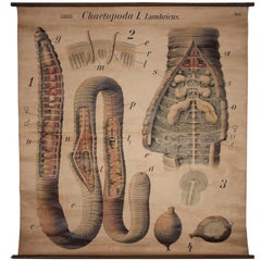
- Antique Earthworm Scientific Educational Chart by Pfurtscheller Denoyer-GeppertLocated in Oakville, CTAntique earthworm Scientific educational chart by Pfurtscheller Denoyer-Geppert "Chaetopoda I. Lumbricus" 51" x 55", Wooden rod measures 53".Category
Mid-20th Century Prints
MaterialsCanvas
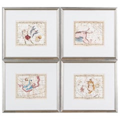
- Set of Four Antique French Celestial Engravings from John Flamsteed "Atlas CeleLocated in Bridgeport, CTIncluding: Le Serpent, Le Bouvier, Pegase and Hercule along with other identified constellations on each page. Le Serpent with a fold down the center. The French edition of 27 plates...Category
Antique Late 18th Century European Regency Decorative Art
MaterialsPaper
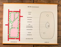
- Pair of Vintage Belgian School Charts of CellsLocated in Houston, TXThe chart also includes its original wooden dowels from which it can be hung. Pair of vintage Belgian school charts printed on cloth likely dating from the 1960s. Very graphic and in...Category
Vintage 1960s Belgian Other Prints
MaterialsPaper
- Antique French Educational Scientific Chart, Tissu Nerveux by Denoyer-GeppertLocated in Oakville, CTAntique French educational Scientific chart, Tissu Nerveux by Denoyer-Geppert. Collection Remy & Cepede. Neurone-Cellules nerveuses-Fibres nerveuses. ...Category
Early 20th Century Prints
MaterialsCanvas
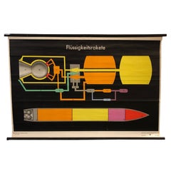
- German Scientific Liquid Rocket Engine ChartLocated in Brooklyn, NYVintage, German, scientific, engineering, roll down chart depicting the construction of a liquid rocket engine (Flussigkeitsrakete) is printed on canvas...Category
Mid-20th Century German Industrial Posters
MaterialsCanvas, Wood, Paper


Recently Viewed
View AllMore Ways To Browse
Antique Celestial
Solar Antique
Antique Solar
Solar Eclipse
Scientific Chart
Celestial Sphere
Armillary Sphere Antique
Antique Armillary Sphere Antiques
Antique Armillary Sphere
Solar System Model
Celestial Atlas
Antique Solar System
Celestial Chart
Antique Celestial Charts
J Gould Prints
Victorian Fashion Lithographs
Funeral Antique
Framed Piranesi