Items Similar to Antique Costume Print of People in the Harz Region in Germany, ca. 1890


Want more images or videos?
Request additional images or videos from the seller
1 of 6
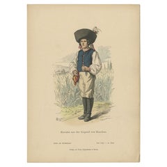
Antique Costume Print of People in the Harz Region in Germany, ca. 1890
About the Item
"Antique print titled 'Harz'. This print shows the costumes of Germany; Harz. This print originates from 'Deutsche Volkstrachten' published by J.G. Bach in Leipzich, 1890.
The Harz is a highland area in northern Germany. It has the highest elevations for that region, and its rugged terrain extends across parts of Lower Saxony, Saxony-Anhalt, and Thuringia. The name Harz derives from the Middle High German word Hardt or Hart (hill forest), Latinized as Hercynia. The Brocken is the highest summit in the Harz with an elevation of 1,141.1 metres (3,744 ft) above sea level. The Wurmberg (971 metres (3,186 ft)) is the highest peak located entirely within the state of Lower Saxony.
Between 1945 and 1990, the Inner German border ran through the Harz, the west belonging to the Federal Republic of Germany (West Germany) and the east to the German Democratic Republic (East Germany). Today the Harz forms a popular tourist destination for summer hiking as well as winter sports.
Artists and Engravers: Albert Kretschmer (27 February 1825 – 11 July 1891) was a German professor, painter, costumes researcher and chairman of Schauspielhaus Berlin.
We also offer thousands of antique prints covering fields of interest as diverse as architecture, natural history, religion, ethnology and many more. Antique prints have long been appreciated for both their aesthetic and investment value. They were the product of engraved, etched or lithographed plates. These plates were handmade out of wood or metal, which required an incredible level of skill, patience and craftsmanship. Whether you have a house with Victorian furniture or more contemporary decor an old engraving can enhance your living space.".
- Dimensions:Height: 12.6 in (32 cm)Width: 9.85 in (25 cm)Depth: 0 in (0.01 mm)
- Materials and Techniques:
- Period:
- Date of Manufacture:1890
- Condition:Condition: Very good, please study image carefully.
- Seller Location:Langweer, NL
- Reference Number:
About the Seller
5.0
Platinum Seller
These expertly vetted sellers are 1stDibs' most experienced sellers and are rated highest by our customers.
Established in 2009
1stDibs seller since 2017
1,940 sales on 1stDibs
Typical response time: <1 hour
- ShippingRetrieving quote...Ships From: Langweer, Netherlands
- Return PolicyA return for this item may be initiated within 14 days of delivery.
More From This SellerView All
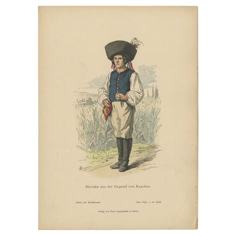
- Antique Costume Print of a Slovake from the Region of Košice, ca 1880Located in Langweer, NLAntique costume print titled 'Slovake aus der Gegend von Kaschau'. Old print showing a Slovake from the area of Košice. This print originates from 'Blätter für Kostümkunde'. The Slov...Category
Antique 19th Century Prints
MaterialsPaper
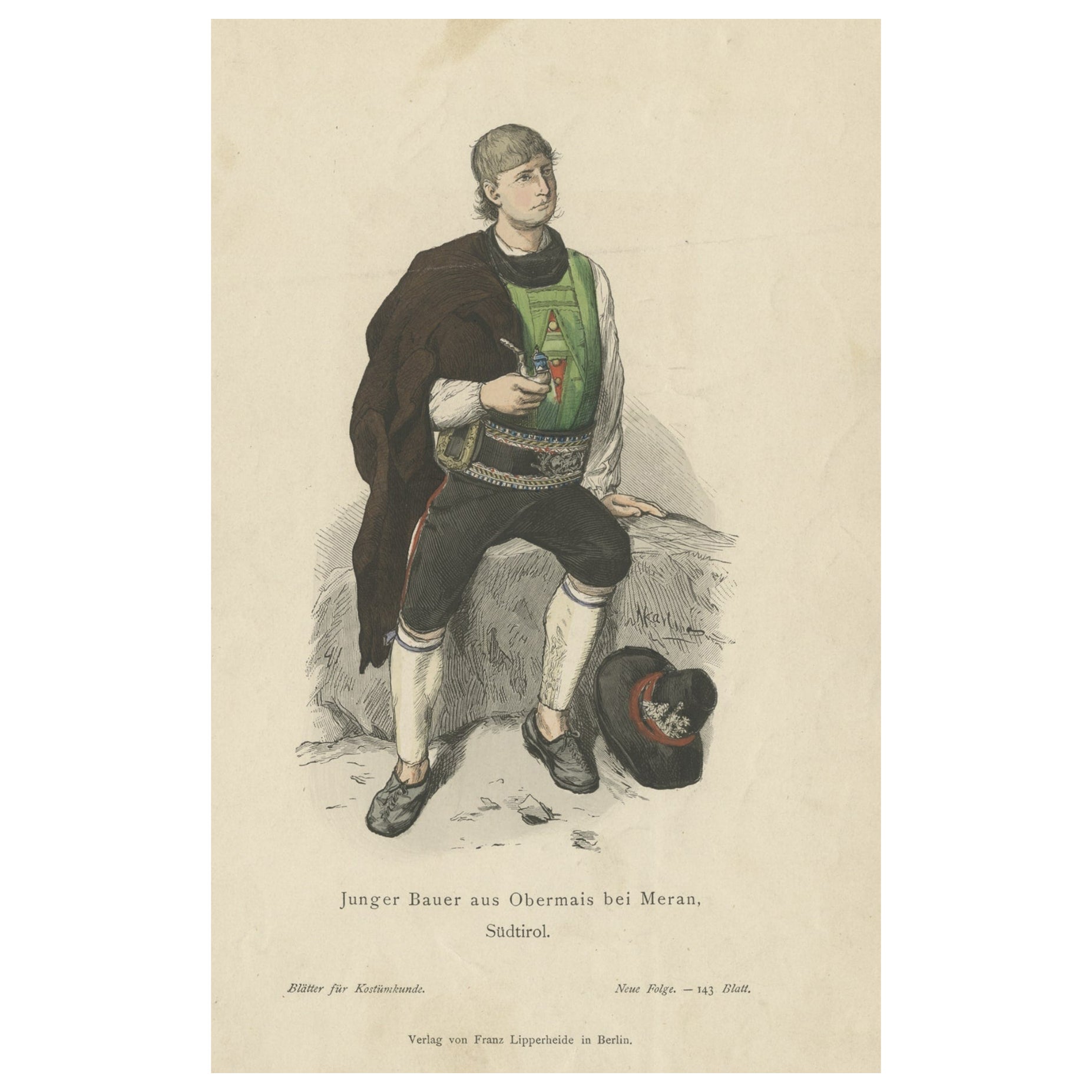
- Antique Costume Print of a Young Farmer from the Region of Obermais, South TyrolLocated in Langweer, NLAntique costume print titled 'Junger Bauer aus Obermais bei Meran, Südtirol'. Old print showing a young farmer from the region of Obermais, near Meran, South Tyrol...Category
Antique 19th Century Prints
MaterialsPaper
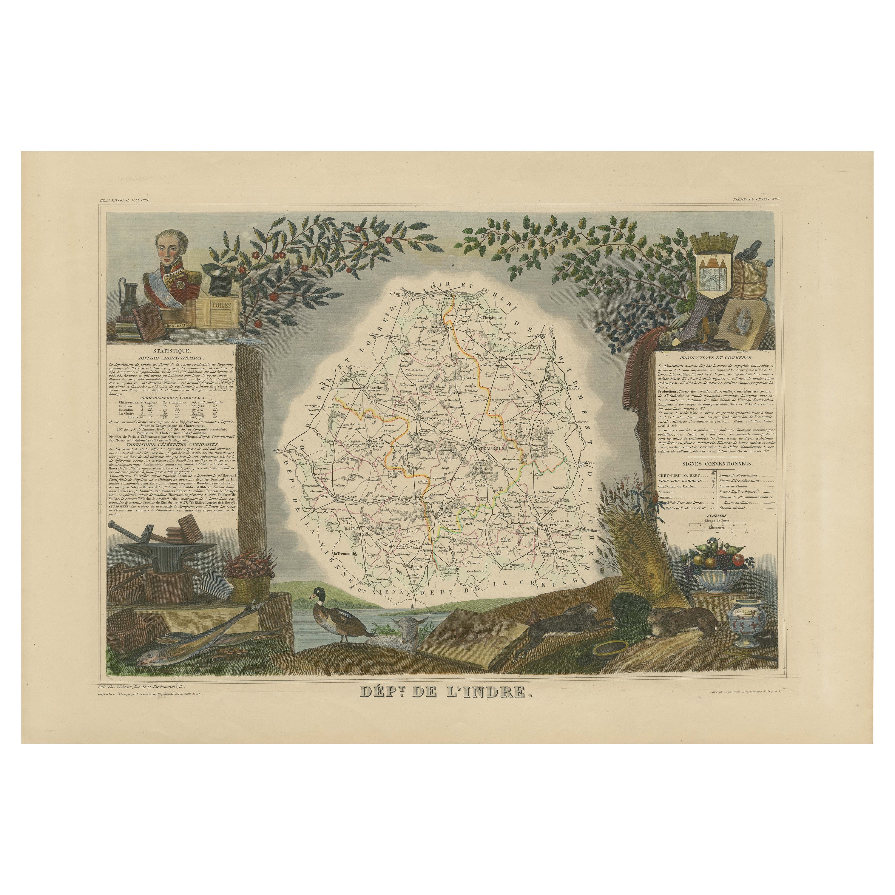
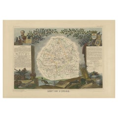
- Antique Map of the Indre Region in France, ca. 1852Located in Langweer, NLAntique map titled 'Dépt. de l'Indre'. Map of the French department of Indre, France. Part of the Loire Valley wine region, this area is known for its production of Chinon wines, typically red, and production of Pouligny-Saint-Pierre, goats'-milk cheese. It is also the birthplace of the great philosopher Rene Descartes...Category
Antique Mid-19th Century Maps
MaterialsPaper
- Antique Map of the Region of Zeitz in Germany, 1749By SchreiberLocated in Langweer, NLAntique map titled 'Das Stifft Zeitz (..)'. Map of the region of Zeitz, Germany. Zeitz is a town in the Burgenlandkreis district, in Saxony-Anhalt, Germany. It is situated on the riv...Category
Antique 18th Century Maps
MaterialsPaper
- Antique Map of the Region of Oldenburg, GermanyBy Willem BlaeuLocated in Langweer, NLAntique map titled 'Oldenburg Comitatus'. Detailed old map of Oldenburg, Germany. The map also shows Bremen and the Jade Bight. Published by W. Blaeu, circa 1640. Willem Jansz. Blaeu...Category
Antique Mid-17th Century Maps
MaterialsPaper
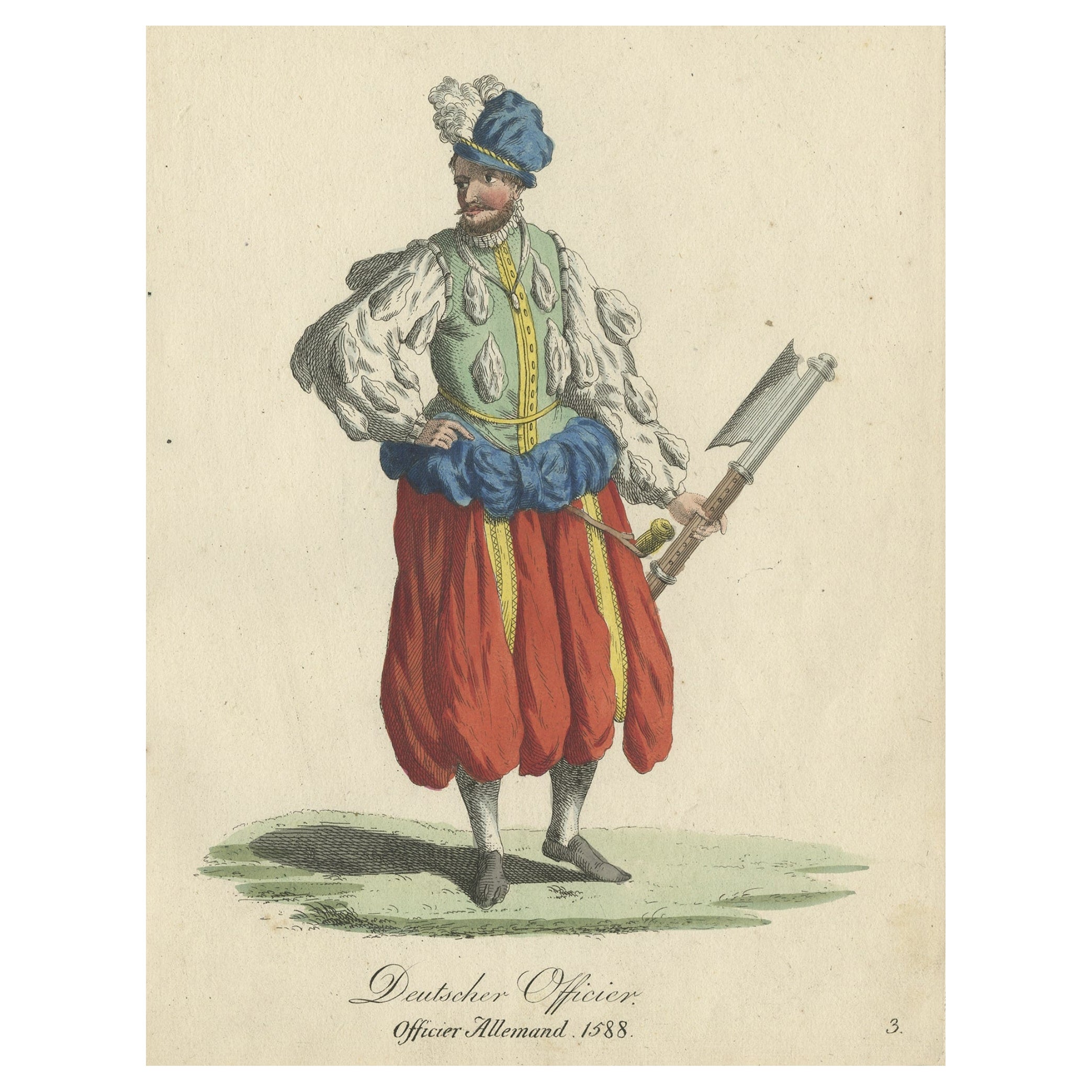
- Original Print of the Costume of a German Officer in 1588, Published in 1805Located in Langweer, NLAntique costume print titled 'Deutscher Officier - Officier Allemand 1588'. This print depicts a German officer. Originates from a rare costume bo...Category
Antique Early 1800s Prints
MaterialsPaper


You May Also Like
- 17th Century Hand-Colored Map of a Region in West Germany by JanssoniusBy Johannes JanssoniusLocated in Alamo, CAThis attractive highly detailed 17th century original hand-colored map is entitled "Archiepiscopatus Maghdeburgensis et Anhaltinus Ducatus cum terris adjacentibus". It was published ...Category
Antique Mid-17th Century Dutch Maps
MaterialsPaper
- Lithographic print on paper, depicting the atlas of the hand, France 1850 ca.Located in Milan, ITAn anatomical lithographic print on paper, depicting the anatomical atlas of the hand. Black lacquered fir wood frame with golden ramin wood batting. N. H. Ja...Category
Antique Mid-19th Century French Prints
MaterialsGlass, Wood, Paper
- 17th Century Hand Colored Map of the Liege Region in Belgium by VisscherBy Nicolaes Visscher IILocated in Alamo, CAAn original 17th century map entitled "Leodiensis Episcopatus in omnes Subjacentes Provincias distincté divisusVisscher, Leodiensis Episcopatus" by Nicolaes Visscher II, published in Amsterdam in 1688. The map is centered on Liege, Belgium, includes the area between Antwerp, Turnhout, Roermond, Cologne, Trier and Dinant. This attractive map is presented in a cream-colored mat measuring 30" wide x 27.5" high. There is a central fold, as issued. There is minimal spotting in the upper margin and a tiny spot in the right lower margin, which are under the mat. The map is otherwise in excellent condition. The Visscher family were one of the great cartographic families of the 17th century. Begun by Claes Jansz Visscher...Category
Antique Late 17th Century Dutch Maps
MaterialsPaper
- Lithographic Print on Paper, Depicting the Male Genital System, France 1850 CaLocated in Milan, ITAn anatomical lithographic print on paper, depicting the male genital system. Black lacquered fir wood frame with golden ramin wood batting. N. H. Jacob, Pari...Category
Antique Mid-19th Century French Prints
MaterialsGlass, Wood, Paper
- The Normandy Region of France: A 17th C. Hand-colored Map by Sanson and JaillotBy Nicolas SansonLocated in Alamo, CAThis large hand-colored map entitled "Le Duché et Gouvernement de Normandie divisée en Haute et Basse Normandie en divers Pays; et par evêchez, avec le Gouvernement General du Havre ...Category
Antique 1690s French Maps
MaterialsPaper
- Antique Lithographic Print of the Diamond Rock Battle Early 1900s, Oakwood FrameLocated in Milan, ITLithographic print of the diamond rock battle, the main port of the island of Martinique, taken from the book Historical Gallery of Versailles 112. Chacoane is the engraver. Original...Category
Early 20th Century French Nautical Objects
MaterialsPaper


Recently Viewed
View AllMore Ways To Browse
Victorian Costume
Antique Sports Prints
Highland House
West Highland
Summer Hart
Forest Hart
Chinese Black China Cabinet
French Gold Medallion
Counter Cabinet
1970s Clothes
Brown Vintage Shoes
Antique Victorian Kitchen Cabinets
Enamel Signed Plate
Antique Narrow Cabinet
Narrow Antique Cabinet
Antique Long Box
1960s Art Nouveau
Kitchen Apron