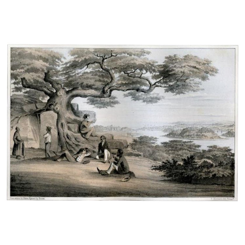
Items Similar to Antique Print of the Marketplace in Anamooka, Tonga Islands, c.1790
Want more images or videos?
Request additional images or videos from the seller
1 of 5
Antique Print of the Marketplace in Anamooka, Tonga Islands, c.1790
About the Item
Antique print titled 'View in Anamooka and the Inhabitants'. Depicts the marketplace that was established in a ring in front of the main house in Anamooka, Tonga - named the Friendly Islands because of his reception when James Cook's third Pacific voyage arrived there in May 1777.
Artists and Engravers: Engraved for Bankes's 'New System of Geography'. Published by Royal Authority.
Condition: Good, age-related toning. Please study image carefully.
Date: c.1790
Overall size: 38.6 x 23.2 cm.
Image size: 30.6 x 21.5 cm.
A View at Anamooka
This engraving after a drawing comes from the official account of Cook's third voyage, 'A voyage to the Pacific Ocean'.
Captain James Cook (1728-1779) made three separate voyages to the Pacific (with the ships Endeavour, Resolution, Adventure, and Discovery) and did more than any other voyager to explore the Pacific and Southern Ocean. Cook not only encountered Pacific cultures for the first time, but also assembled the first large-scale collections of Pacific objects to be brought back to Europe. He was killed in Hawaii in 1779.
Cook was in Nomuka (Annamooka), Tonga or Friendly Isles from May 1-14, 1777.
"On May 2 1777 the expedition reached Nomuka and anchored in the harbour on the north side of the island, which Cook had already used in June 1774. Both ships were in want of refreshments. A camp was erected on shore both as a trading post and a workshop for repairs. Watering, cutting wood, and above all bartering for food became the main occupation during the next days."
In this drawing, the building of relationships and trafficking with the Nomukans are embraced within a broad panorama of documented history. The ships are in this case too far out at sea to be included in the picture though -- as before -- their presence is hinted at by the ships' boats in the harbour. Some are loaded with water barrels, others are being used for transport of food, which is piled up on shore. In the left foreground a native outrigger is being pulled on to the shore, surrounded by Tongans who lift or carry away fruit. They are moving towards the righ, where, between a large hut and a group of coconut palms a large clearning has been made for a group of Nomukans, sitting cross-legged in a circle. In the middle of this hogs, yams, plantains etc. are collected and the marines within the circle are probably engaged in transporting goods received. The presence of the marines is underlined by a pyramid of rifles. They were stationed there 'for the protection of the horses and the waterers'. Two horses may be seen to the right of the hut resting under the shade of a large breadfruit tree. A few yards in front of the tree stands an indigenous hut with open sides and a thatched roof, built on poles. Several Nomukans sit within.
Many studies were necessary to build up a comprehensive scene like this.
Whilst cartography holds a special place in our collection, we also offer thousands of antique prints covering fields of interest as diverse as architecture, natural history, religion, ethnology and many more. Antique prints have long been appreciated for both their aesthetic and investment value. They were the product of engraved, etched or lithographed plates. These plates were handmade out of wood or metal, which required an incredible level of skill, patience and craftsmanship. Whether you have a house with Victorian furniture or more contemporary decor an old engraving can enhance your living space. We offer a wide range of authentic antique prints for any budget.
- Dimensions:Height: 9.14 in (23.2 cm)Width: 15.2 in (38.6 cm)Depth: 0 in (0.01 mm)
- Materials and Techniques:
- Period:
- Date of Manufacture:circa 1790
- Condition:Condition: Good, age-related toning. Please study image carefully.
- Seller Location:Langweer, NL
- Reference Number:
About the Seller
5.0
Platinum Seller
These expertly vetted sellers are 1stDibs' most experienced sellers and are rated highest by our customers.
Established in 2009
1stDibs seller since 2017
1,940 sales on 1stDibs
Typical response time: <1 hour
- ShippingRetrieving quote...Ships From: Langweer, Netherlands
- Return PolicyA return for this item may be initiated within 14 days of delivery.
More From This SellerView All
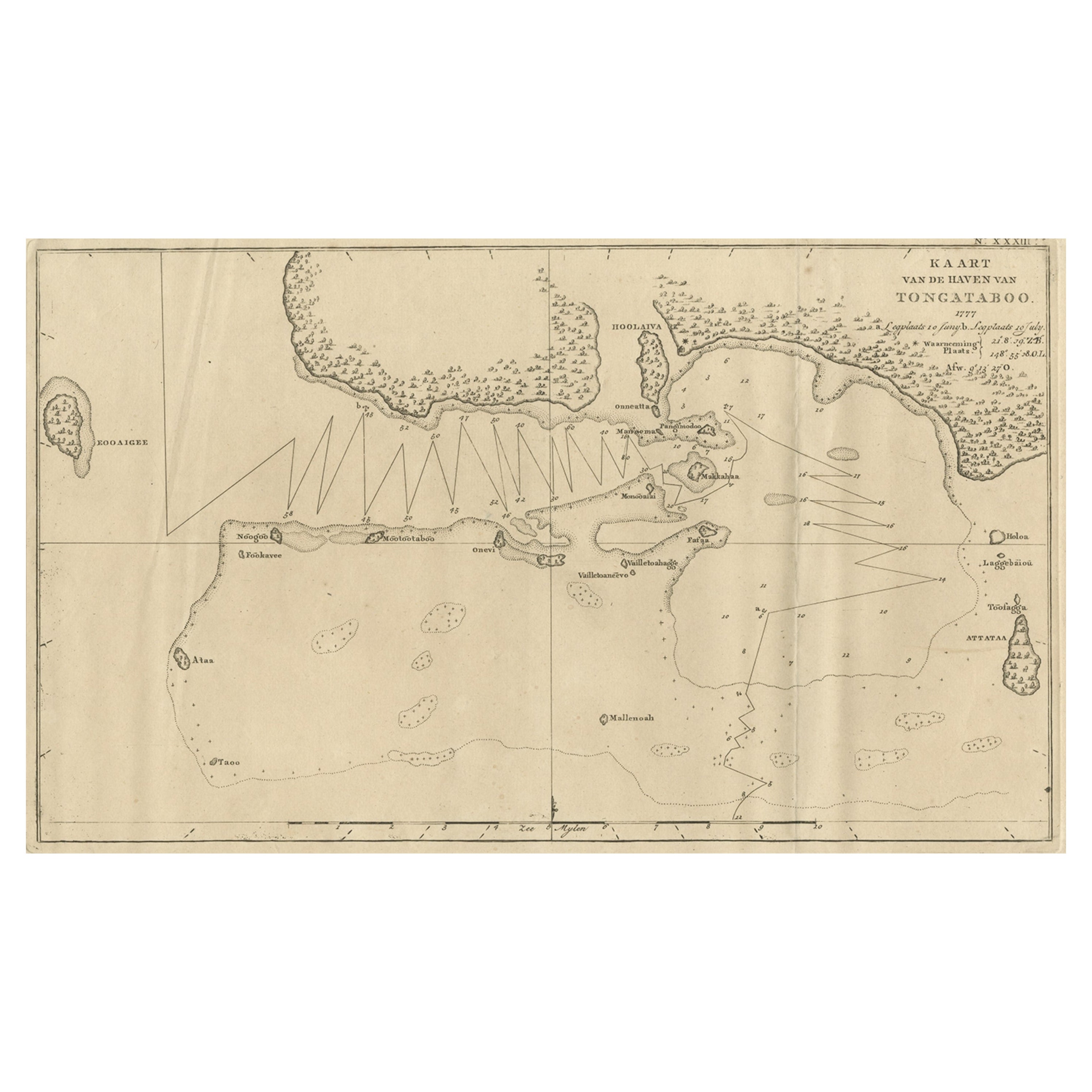
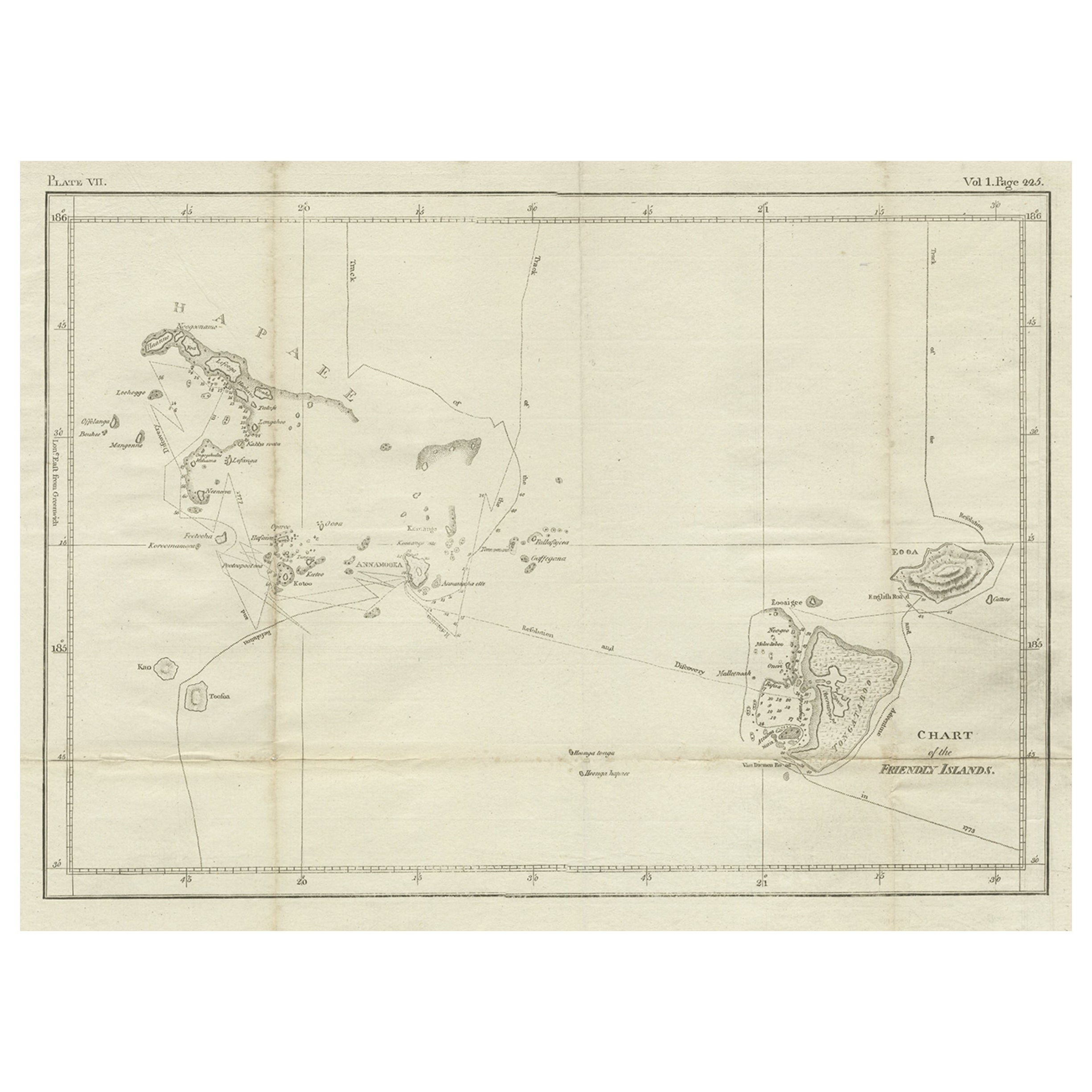
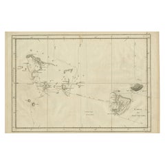
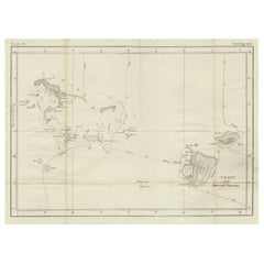
- Antique Map of the Harbour of Tongatabu, One of the Tonga Islands, 1803Located in Langweer, NLAntique map Tonga titled 'Kaart van de Haven van Tongataboo'. Antique map of the harbour of Tongatabu, one of the Tonga Islands. Originates from 'Reizen Rondom de Waereld door Ja...Category
Antique Early 1800s Maps
MaterialsPaper
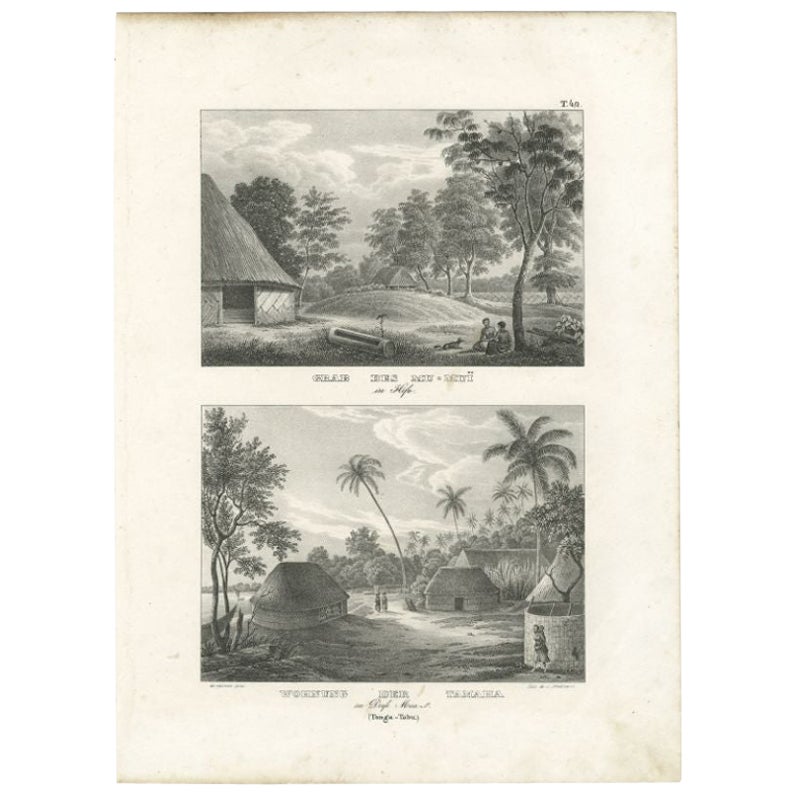
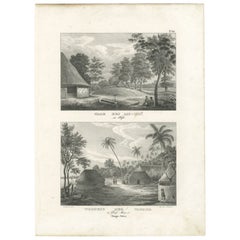
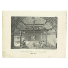
- Antique Print of the Tomb of Mu-Muï in Tonga, c.1836Located in Langweer, NLAntique print titled 'Grab des Mu-Muï' and 'Wohnung der Tamaha im Dorfe Mua'. Old print with two views, the upper image depicts the tomb of Mu-Muï. The lower image depicts a residenc...Category
Antique 19th Century Prints
MaterialsPaper
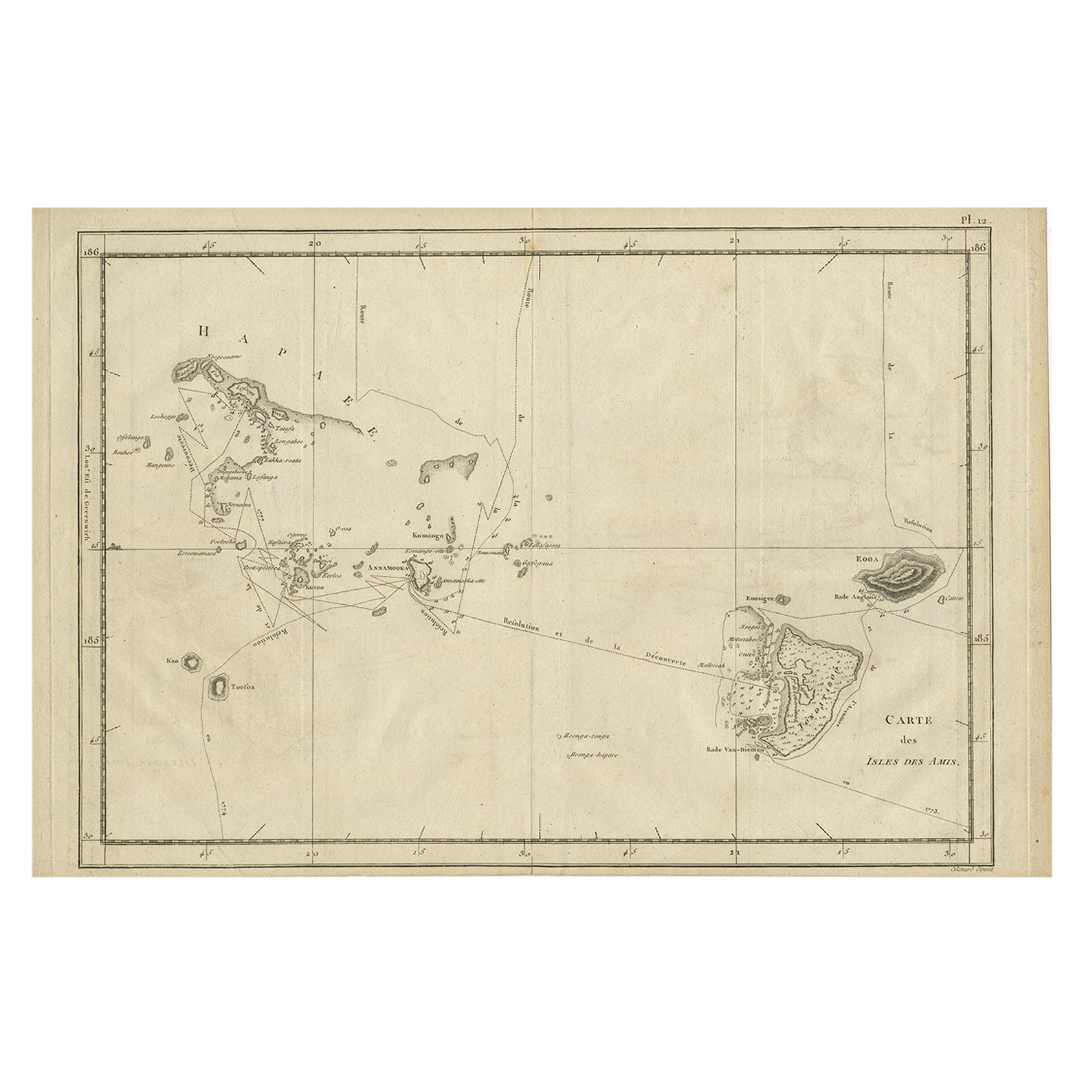
- Antique Engraved Map of the Friendly Islands or Tonga, ca.1785Located in Langweer, NLAntique map titled 'Carte des Isles des Amis'. Map of the Friendly Islands / Tonga. The Tongan people first encountered Europeans in 1616 when the Dutch vessel Eendracht, captain...Category
Antique 1780s Maps
MaterialsPaper
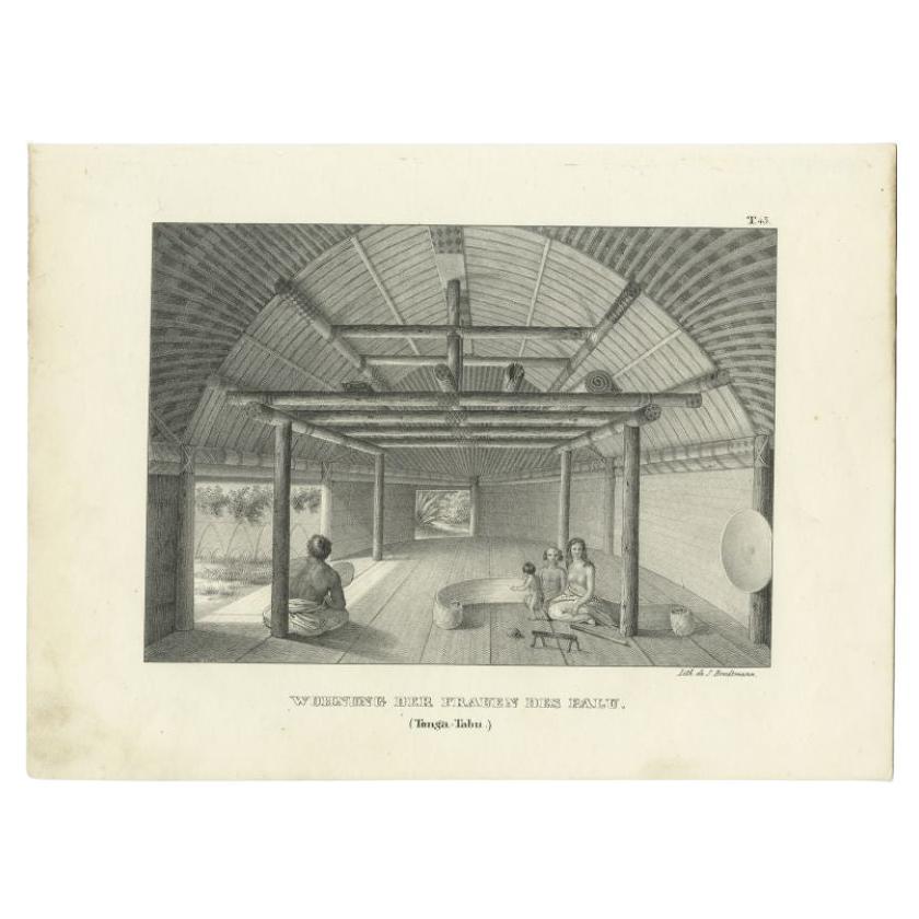
- Original Antique Print of the Women of Tonga Tabu, c.1836Located in Langweer, NLAntique print titled 'Wohnung der Frauen des Palu'. Old print with a view of the hut of the women of Tonga Tabu. This print originates from 'Entdeckungs, Reise der Franzosischen Corv...Category
Antique 19th Century Prints
MaterialsPaper
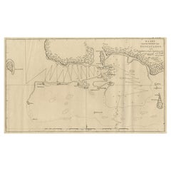
- Antique Chart of the Friendly Islands or Nowadays Tonga, by Cook, 1784By James CookLocated in Langweer, NLAntique print titled 'Chart of the Friendly Islands'. Antique map of the Friendly Islands depicting Rotterdam or Anamocka, Middelburg or Eaoowe and Amsterdam or Tongatabu. Originates...Category
Antique 18th Century Prints
MaterialsPaper
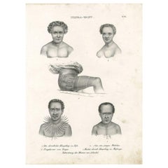
- Antique Print of Inhabitants of Tonga Tabu, C.1836Located in Langweer, NLAntique print titled 'Tonga-Tabu'. Old print depicting various inhabitants of Tonga Tabu. This print originates from 'Entdeckungs, Reise der Franzosischen Corvette Astrolabe Unternomen auf Befehl Konig Karls...Category
Antique 19th Century Prints
MaterialsPaper
You May Also Like
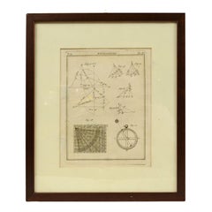
- Engraving on Copper Print from the Volume Navigazione Nautical Subject 1790Located in Milan, ITPrint by engraving on copper plate Tav III TIX fig. 17-22 from the volume Navigazione; with frame 28 x 33. Some calculations are depicted. Very good condition. Shipping is insured by...Category
Antique 1790s Italian Nautical Objects
MaterialsPaper
- Original Antique Map of Spain and Portugal, circa 1790Located in St Annes, LancashireSuper map of Spain and Portugal Copper plate engraving by A. Bell Published, circa 1790. Unframed.Category
Antique 1790s English Other Maps
MaterialsPaper
- Hand-Colored 18th Century Homann Map of Denmark and Islands in the Baltic SeaBy Johann Baptist HomannLocated in Alamo, CAAn 18th century copper plate hand-colored map entitled "Insulae Danicae in Mari Balthico Sitae utpote Zeelandia, Fionia, Langelandia, Lalandia, Falstria, Fembria Mona" created by Joh...Category
Antique Early 18th Century German Maps
MaterialsPaper
- Antique Lithographic Print of the Diamond Rock Battle Early 1900s, Oakwood FrameLocated in Milan, ITLithographic print of the diamond rock battle, the main port of the island of Martinique, taken from the book Historical Gallery of Versailles 112. Chacoane is the engraver. Original...Category
Early 20th Century French Nautical Objects
MaterialsPaper
- Civil War Panorama of the Seat of War by John Bachmann, Antique Print circa 1864Located in Colorado Springs, COPanorama of the seat of war. Bird's-eye View of Virginia, Maryland, Delaware and the District of Columbia. This third state of this fascinating bird's eye view of the northernmost p...Category
Antique 1860s American Maps
MaterialsPaper
- N.E. View of the United States Capitol, Washington, DC Antique Proof Print 1858Located in Colorado Springs, COThis engraved print shows a view of the United States Capitol Building, in Washington, D.C. The print depicts the neoclassical building from the northeast orientation, with a bustling street scene in front. The steel engraving is a proof printing, drawn and engraved by Henry Sartain and published in 1858. Plans began in May 1854 to build a new cast-iron dome for the United States Capitol. The then-architect of the Capitol Thomas Walter and his team were sold on the aesthetics of a new dome, as well as the utility of a fire-proof one. A year later, on March 3, 1855, President Franklin Pierce...Category
Antique 1850s American Prints
MaterialsPaper


Recently Viewed
View AllMore Ways To Browse
Marketplace Used Furniture
Marketplace Furniture Used
The Marketplace Used Furniture
Barrel 18th Century
Antique Roof
Antique Water Stand
Used Rifles
Antique Water Picture
Antique Ship Anchor Anchors
Antique Ship Anchor
Antique Ship Anchors
Antique Ships Anchor
18th C Cross
Antique Yard
Cross With Three Rings
C Wood Ring
Hawaiian Antique Wood
Anchor Cross