Items Similar to Hand-Colored Print of Folkestone 'United Kingdom' as Seen from the East, 1822


Want more images or videos?
Request additional images or videos from the seller
1 of 5
Hand-Colored Print of Folkestone 'United Kingdom' as Seen from the East, 1822
About the Item
Antique print titled 'Folkestone'.
This print depicts the town of Folkestone (United Kingdom) as seen from the East, the viewpoint high on the cliffs above the Warren, with cattle and sheep grazing on the grassy chalk above Wear Bay. Beyond are two Martello Towers and, in the distance, with a dramatic sky as backdrop, lies the sunlit town with the parish church as its focus. Originates from 'Britannia Delineata' by Hullmandel.
Artists and Engravers: Charles Joseph Hullmandel (ca. 1789-ca. 1860) was a pupil of Senefelder. He was one of the very early lithographers in England.
- Dimensions:Height: 12.41 in (31.5 cm)Width: 16.93 in (43 cm)Depth: 0 in (0.02 mm)
- Materials and Techniques:
- Period:
- Date of Manufacture:1822
- Condition:Wear consistent with age and use. Condition: Good, some minor defects and a tear to the left. Please study image carefully.
- Seller Location:Langweer, NL
- Reference Number:Seller: BG-11319 1stDibs: LU3054326972932
About the Seller
5.0
Platinum Seller
These expertly vetted sellers are 1stDibs' most experienced sellers and are rated highest by our customers.
Established in 2009
1stDibs seller since 2017
1,916 sales on 1stDibs
Typical response time: <1 hour
- ShippingRetrieving quote...Ships From: Langweer, Netherlands
- Return PolicyA return for this item may be initiated within 14 days of delivery.
Auctions on 1stDibs
Our timed auctions are an opportunity to bid on extraordinary design. We do not charge a Buyer's Premium and shipping is facilitated by 1stDibs and/or the seller. Plus, all auction purchases are covered by our comprehensive Buyer Protection. Learn More
More From This SellerView All
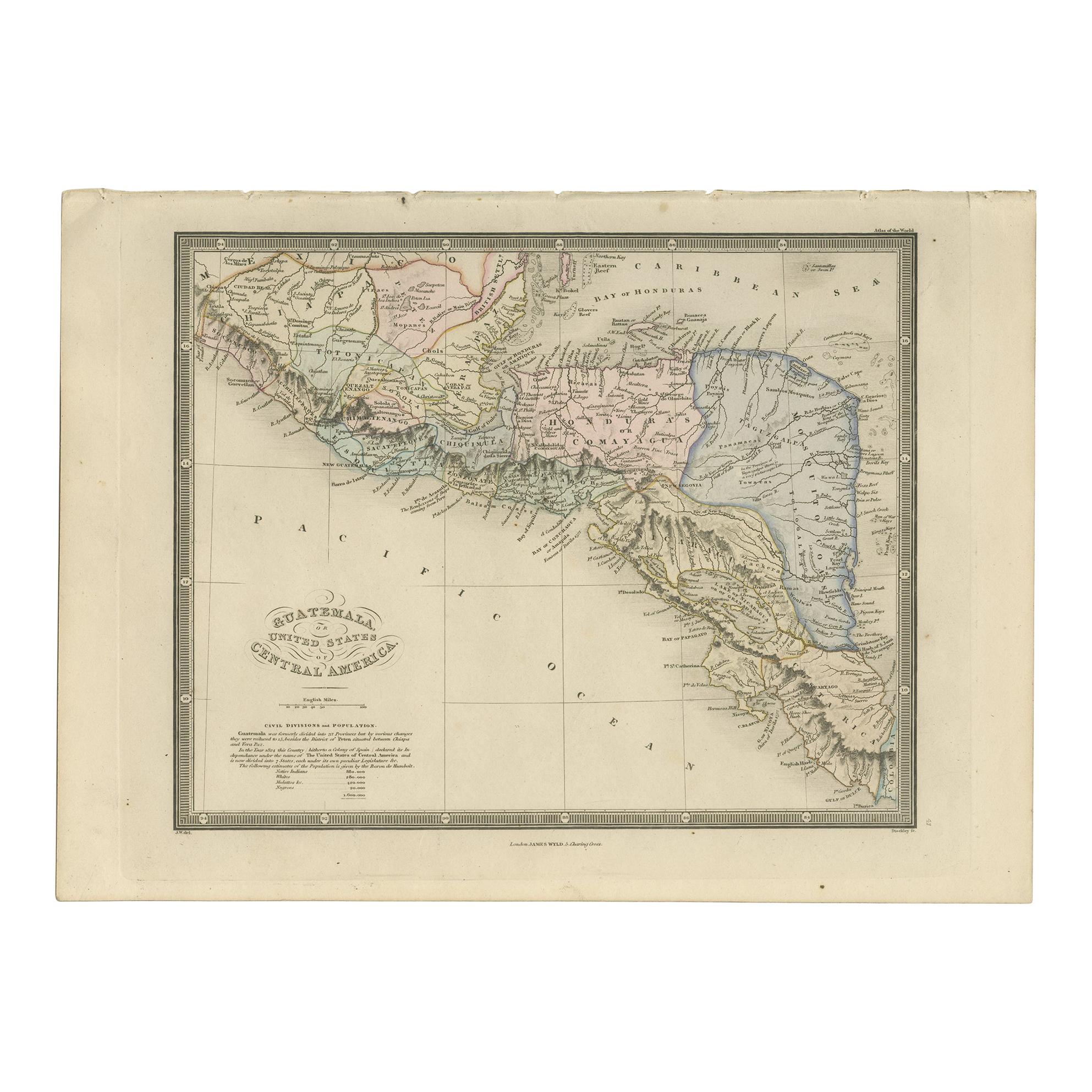
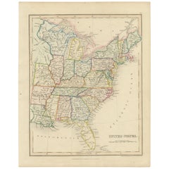
- Original Antique Hand-colored Map of the United States, circa 1845Located in Langweer, NLAntique map titled 'United States'. Old map of the United States, includes the last part of the North West Territory (present day Wisconsin and part of Minnesota). It also marks Ft. Crawford at the confluence of the Mississippi River and the Ouisconsin River (present day Wisconsin River). Published by Orr & Company; Amen Corner...Category
Antique Mid-19th Century Maps
MaterialsPaper
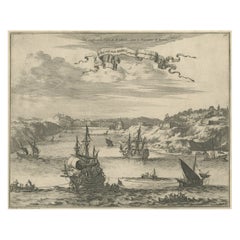
- Bird's Eye View of Dabhol as Seen from the Sea, North of Goa, India, 1727Located in Langweer, NLAntique print titled 'De Bay ende Stadt Dabul'. Bird's eye view of Dabhol as seen from the sea. The city is situated on the Vashishti river, north of Goa in India, on the Malabar...Category
Antique 1720s Maps
MaterialsPaper
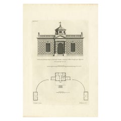
- Antique Print of Designs for Ebberston Lodge, Yorkshire, United Kingdom, 1725Located in Langweer, NLAntique print titled 'The Elevation of Ebberston Lodge (..)'. Designs for Ebberston Lodge, near Scarborough, Yorkshire, England. This print originates from 'Vitruvius Britannicus' ...Category
Antique 18th Century Prints
MaterialsPaper
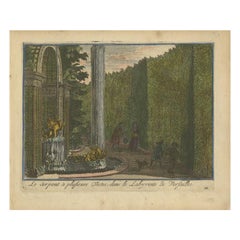
- Antique Hand-Colored Print of the Labyrinth of Versailles, c.1720Located in Langweer, NLAntique print titled 'Le Serpent à plusieurs Testes: dans le Labyrinte de Versailles'. This print illustrates the fable 'The Snake with several heads' of the labyrinth of Versailles ...Category
Antique 18th Century Prints
MaterialsPaper
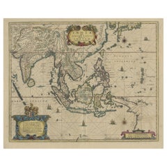
- Original Antique Hand-Colored Map of The East Indies and Southeast Asia, c.1644Located in Langweer, NLAntique map titled 'India quae Orientalis dicitur, et Insulae adiacentes'. Old map of the East Indies and Southeast Asia showing the area between India in the West and parts of J...Category
Antique 1640s Maps
MaterialsPaper
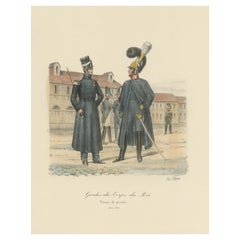
- Old Hand-Colored Print of the Guards of the King of France, 1890Located in Langweer, NLAntique print titled 'Gardes-du-Crops du Roi'. Old print of the Guards of the King of France. This print originates from 'Histoire de la maison militaire du roi de 1814 à 1830 : ...Category
Antique 1890s Prints
MaterialsPaper
You May Also Like
- The Kingdom of Naples and Southern Italy: A Hand-Colored 18th Century Homann MapBy Johann Baptist HomannLocated in Alamo, CA"Novissima & exactissimus Totius Regni Neapolis Tabula Presentis Belli Satui Accommo Data" is a hand colored map of southern Italy and the ancient Kingdom of Naples created by Johann...Category
Antique Early 18th Century German Maps
MaterialsPaper
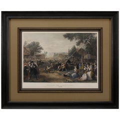
- "Raising the Liberty Pole" Hand-Colored Antique Print, 1875Located in Colorado Springs, COThis nineteenth-century engraving shows a liberty pole being raised in a town square in 1776, while a sign bearing the face of King George III is removed in the background. The rioto...Category
Antique 1870s American Historical Memorabilia
MaterialsPaper
- N.E. View of the United States Capitol, Washington, DC Antique Proof Print 1858Located in Colorado Springs, COThis engraved print shows a view of the United States Capitol Building, in Washington, D.C. The print depicts the neoclassical building from the northeast orientation, with a bustling street scene in front. The steel engraving is a proof printing, drawn and engraved by Henry Sartain and published in 1858. Plans began in May 1854 to build a new cast-iron dome for the United States Capitol. The then-architect of the Capitol Thomas Walter and his team were sold on the aesthetics of a new dome, as well as the utility of a fire-proof one. A year later, on March 3, 1855, President Franklin Pierce...Category
Antique 1850s American Prints
MaterialsPaper
- Hand-Colored 18th Century Homann Map of the Danube, Italy, Greece, CroatiaBy Johann Baptist HomannLocated in Alamo, CA"Fluviorum in Europa principis Danubii" is a hand colored map of the region about the Danube river created by Johann Baptist Homann (1663-1724) in his 'Atlas Novus Terrarum', publish...Category
Antique Early 18th Century German Maps
MaterialsPaper
- Germany West of the Rhine: A Hand-colored 18th Century Map by de WitBy Frederick de WitLocated in Alamo, CAThis original 18th century hand-colored map of the county of Moers, Germany entitled "Illustrissimo Celsissmo Principi GUILIELMO HENRICO D.G. Arausionum Principi Domino suo Clementis...Category
Antique Early 18th Century Dutch Maps
MaterialsPaper
- 17th Century Hand Colored Map of the Liege Region in Belgium by VisscherBy Nicolaes Visscher IILocated in Alamo, CAAn original 17th century map entitled "Leodiensis Episcopatus in omnes Subjacentes Provincias distincté divisusVisscher, Leodiensis Episcopatus" by Nicolaes Visscher II, published in Amsterdam in 1688. The map is centered on Liege, Belgium, includes the area between Antwerp, Turnhout, Roermond, Cologne, Trier and Dinant. This attractive map is presented in a cream-colored mat measuring 30" wide x 27.5" high. There is a central fold, as issued. There is minimal spotting in the upper margin and a tiny spot in the right lower margin, which are under the mat. The map is otherwise in excellent condition. The Visscher family were one of the great cartographic families of the 17th century. Begun by Claes Jansz Visscher...Category
Antique Late 17th Century Dutch Maps
MaterialsPaper


Recently Viewed
View AllMore Ways To Browse
Antique Sheep Print
East Bay Used Furniture
Antique French Wall Tapestry
Large Coin
Antique Wool Tapestry
Midcentury Brutalist Wall
Antique Lacquer Cabinet
Antique Flower Pendant
Display Cabinets Light
Lighted Display Cabinet
Regency Pair Of Cabinets
Pair Of Wide Cabinets
Metal Cabinets With Glass Doors
Domed Band
Display Shelves With Drawers
Tall Storage Cabinet Glass
Glass Fronted Cabinet Mid Century
Used Corner Display Cabinet