Items Similar to Vintage Rollable Map Northern Germany Poland Seaside Wallchart Baltic Sea


Want more images or videos?
Request additional images or videos from the seller
1 of 6
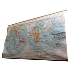
Vintage Rollable Map Northern Germany Poland Seaside Wallchart Baltic Sea
About the Item
The large impressive cottagecore pull-down map illustrates Northern Germany, Poland and parts of the Baltic Sea. It was published by Westermann-Schulwandkarten. Used as teaching material in German schools. Colorful print on paper reinforced with canvas,
Measurements:
Width 242,50 cm (95.47 inch)
Height 263 cm (60.43 inch)
The measurements shown refer just to the canvas and do not include the poles.
Background information on the history of school wall charts:
The idea to upgrade every day school life by using pictures was supported in the late 18th century by Johann Bernhard Basedow. In 1774 he published a four-volume book "Elementarwerk" which combined pictures, text and information with merely hundred copperplates. Modern printing methods enabled the spread from rich private schools to rural grade schools. From 1820-1836 the oldest mentioned series of wall charts were published with the range of six booklets including 63 large sized charts. The rising 20th century was the golden age for publishers printing wall charts. Artists Masterly performed pictures which combined the subject-specific standards of a scientist with the standards given by an educator and finally created a magnificent art work.
artfour is an owner-managed trading company dealing in Black Forest woodcarvings, antler furniture and an impressive variety of unique decorative items. Our antiques are displayed in a 100 years old barn in southern Germany which we have remodeled ourselves. Antique pieces have been our passion since the 1980s. We ship worldwide, perfectly packed and with money back guarantee. This qualifies us as your preferred partner for Black Forest and antique art.
- Dimensions:Height: 60.63 in (154 cm)Width: 95.67 in (243 cm)Depth: 0.79 in (2 cm)
- Style:Country (In the Style Of)
- Materials and Techniques:
- Place of Origin:
- Period:
- Date of Manufacture:circa 1970
- Condition:Wear consistent with age and use. The wall chart has been utilised and therefore shows age-related traces of usage. During storage the chart might partly be fissured, stained, sometimes smells and may have some old repairs. Please contact us for a detailed report .
- Seller Location:Berghuelen, DE
- Reference Number:
About the Seller
5.0
Platinum Seller
These expertly vetted sellers are 1stDibs' most experienced sellers and are rated highest by our customers.
Established in 1989
1stDibs seller since 2013
498 sales on 1stDibs
Typical response time: 2 hours
- ShippingRetrieving quote...Ships From: Berghuelen, Germany
- Return PolicyA return for this item may be initiated within 30 days of delivery.
More From This SellerView All
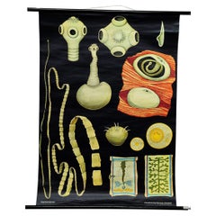
- Jung Koch Quentell Vintage Rollable Wallchart TapewormLocated in Berghuelen, DEA traditional pull-down wall chart by Jung Koch Quentell illustrating the armed tapeworm, Taenia solium. Used as teaching material in German schools. colorful print on paper reinforc...Category
Vintage 1970s German Country Prints
MaterialsCanvas, Wood, Paper
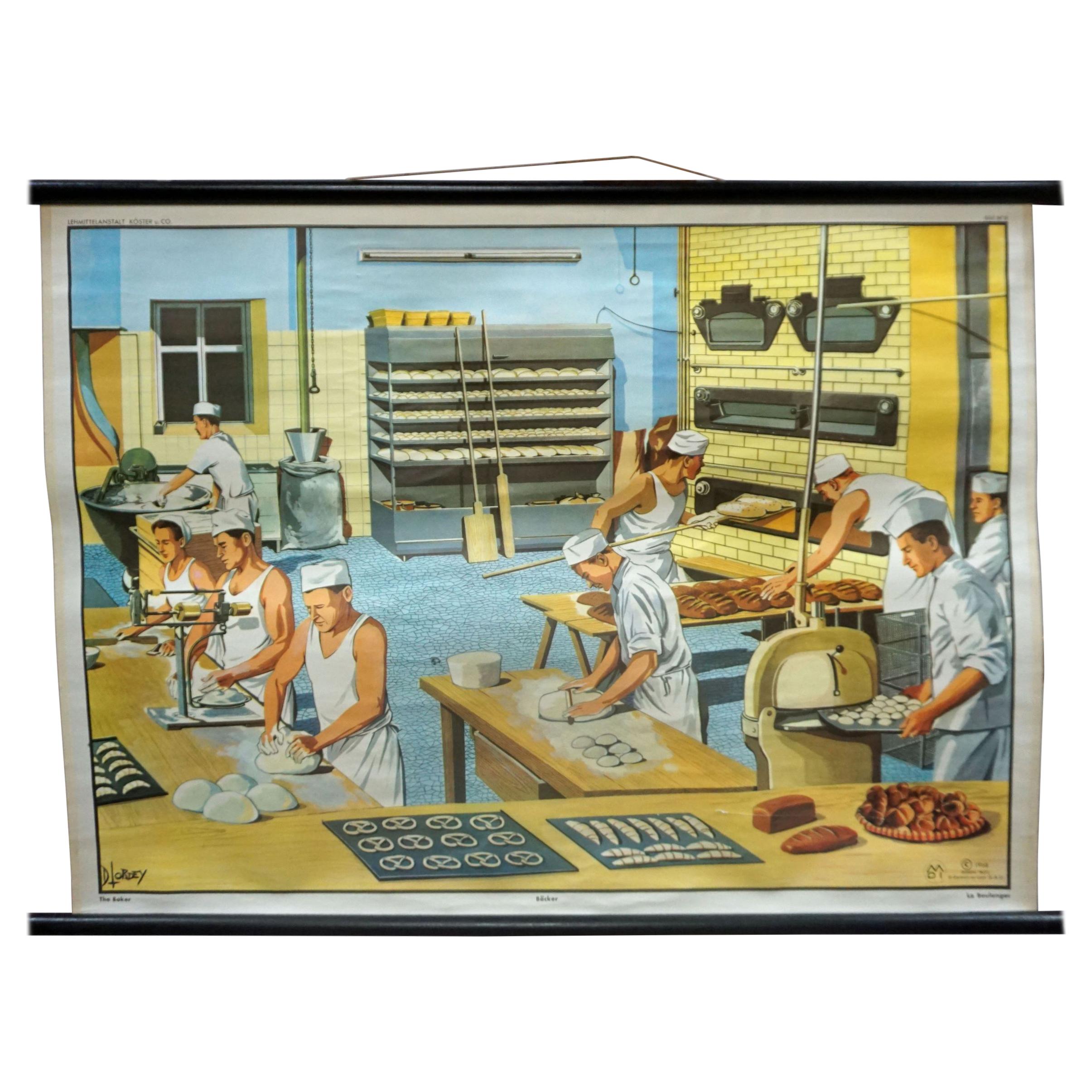
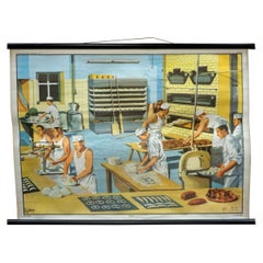
- Vintage Wallchart the Backery D.Lordey Rollable Poster PrintLocated in Berghuelen, DEa cottagecore vintage pull-down wallchart illustrating the job of a baker (view into a backery of the 1970s). the artist is D.Lordey, published by the Lehrmittelanstalt Koester & Co....Category
Vintage 1970s German Country Prints
MaterialsCanvas, Wood, Paper
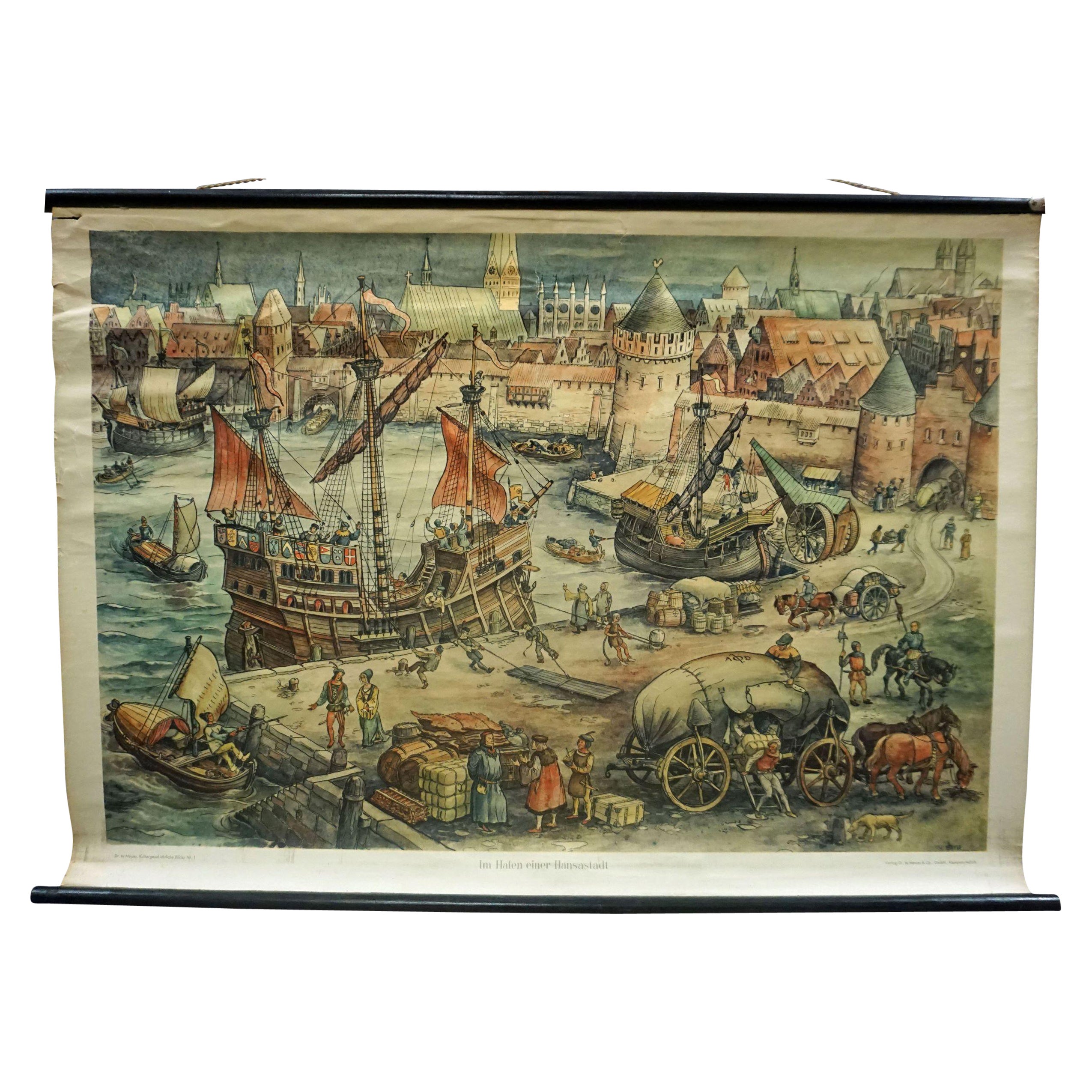
- Harbour of a Trade City Hanseatic Port Rollable Vintage WallchartLocated in Berghuelen, DEThe maritime look vintage pull-down wall chart shows the historical picture of a port of an ancient trading city, published by Verlag Dr. te. Neues & Co., GmbH. Colorful print on pap...Category
Vintage 1970s German Country Prints
MaterialsCanvas, Wood, Paper
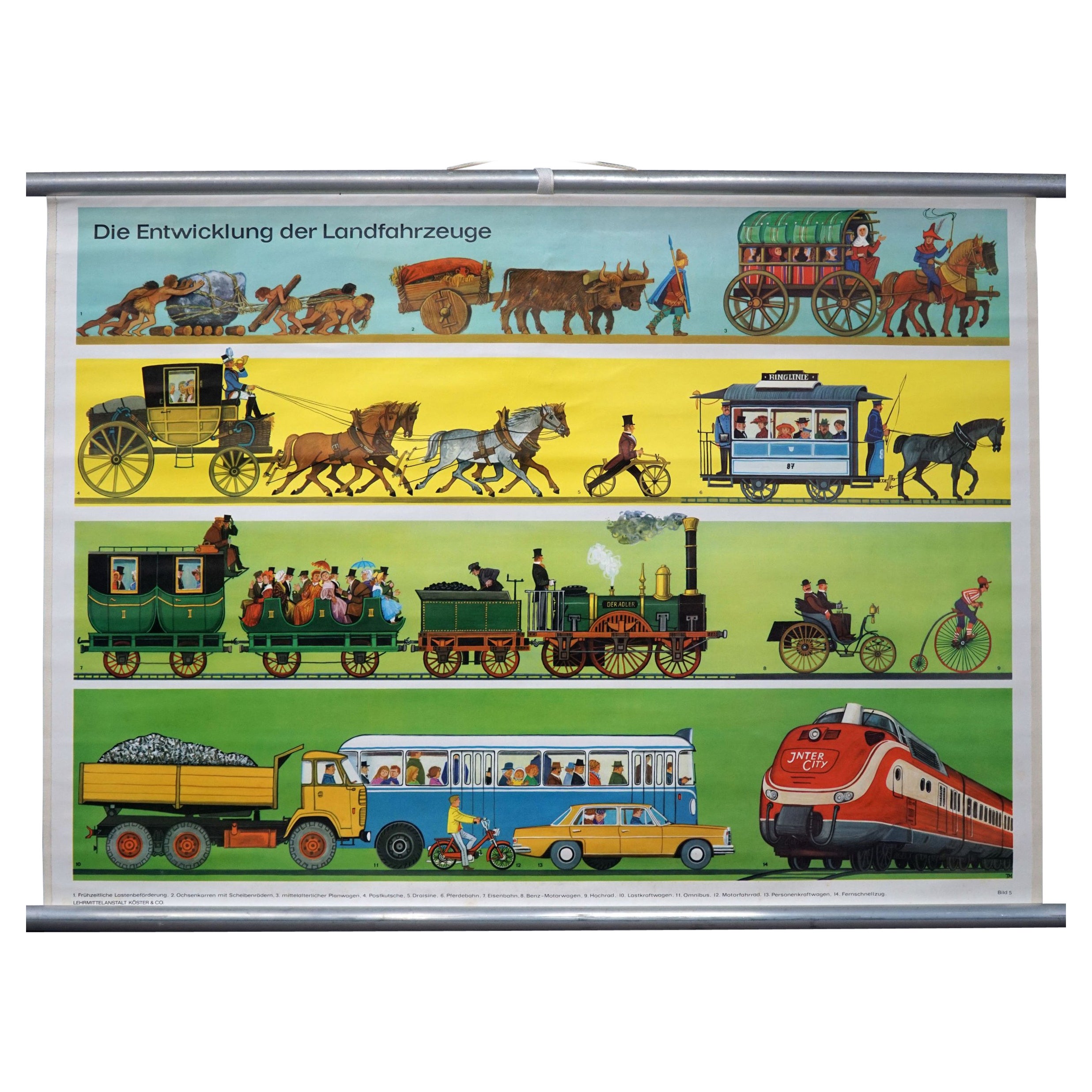
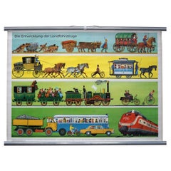
- Vintage Traffic Wallchart Development of Land Vehicles Rollable PosterLocated in Berghuelen, DEThe vintage pull-down traffic wall chart shows a pictorial representation of the development of land vehicles from early cargo transportation, an ox cart with disc wheels, medieval c...Category
Vintage 1970s German Country Prints
MaterialsCanvas, Wood, Paper
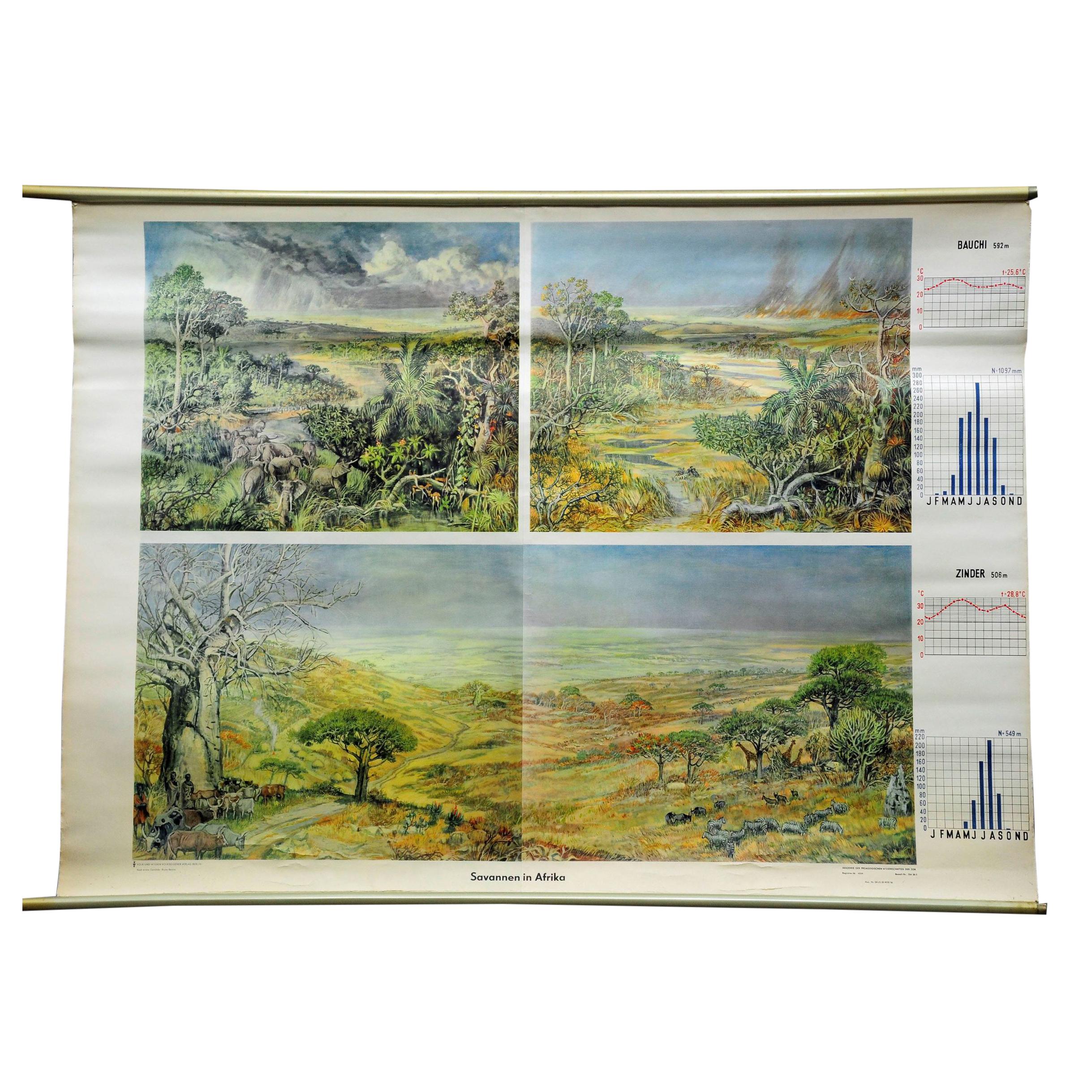
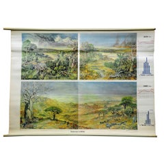
- Vintage Cottagecore Rollable Wallchart Africa Savanna Landscape Weather SeasonsLocated in Berghuelen, DEA countrycore pull-down wallchart illustrating the African savanna landscape during the yearly seasons (supported by climate graphs), cozyness wild animals (e.g. elephants) and farmi...Category
Vintage 1970s German Country Prints
MaterialsMetal
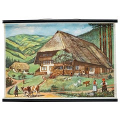
- Cottagecore Mural Black Forest Farming House Vintage Rollable WallChartLocated in Berghuelen, DECottagecore Mural Black Forest Farming House Vintage Rollable WallChart The vintage pull-down wallchart illustrates a typical Black Forest farmhouse su...Category
Vintage 1970s German Country Posters
MaterialsCanvas, Wood, Paper

You May Also Like
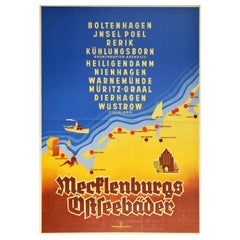
- Original Vintage Poster Mecklenburg Germany Baltic Sea Beach Resorts Travel MapLocated in London, GBOriginal vintage travel poster promoting Mecklenburg Baltic seaside resorts - Boltenhagel, Jnsel Poel island, Rerik, Kuhlungsborn (Brunshaupten-Arendsee), Heiligendamm, Nienhagen, Wa...Category
Vintage 1930s German Art Deco Posters
MaterialsPaper
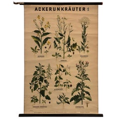
- German Educational Field Weeds Botanical Roll-Up ChartLocated in Brooklyn, NYGerman educational, botanical chart illustrating Ackerunkräuter 1 / field weeds is printed on canvas-backed paper on painted maple rods with string and...Category
Mid-20th Century German Industrial Prints
MaterialsMetal
- Original Antique Map of the Northern Baltic RegionLocated in Langweer, NLTitle: "Livonia: Antique Map of the Northern Baltic Region" Description: This antique map, titled "Livonia," is a detailed representation of the northern Baltic region. Centered on ...Category
Antique Early 17th Century Maps
MaterialsPaper
- Antique Map of Europe Stretching from Northern Africa to the Baltic Sea, 1719Located in Langweer, NLAntique map titled 'Carte de la Germanie et les diferents Etats ou ses Peuples ont porté leurs conquestes'. Original antique map of Europe stretching from northern Africa to the Balt...Category
Antique 18th Century Maps
MaterialsPaper
- Vintage Geographical Map of the World Map, Vallardi Milan, Early 20th CenturyLocated in Cuneo, Italy (CN)Vintage geographical map or planisphere, published by Vallardi publisher for the municipality of Milan, printed at the beginning of the 20th century,...Category
20th Century Italian Prints
MaterialsPaper
- 'Sea Bath' Original Vintage Poster, Shanghai, Circa. 1940'sLocated in Melbourne, Victoria'Sea Bath' Original Vintage Poster, Shanghai, Circa. 1940's This is an original vintage poster, published by Su Hsuen Tsa Printing Co. Road Shanghai This poster has been linen back...Category
Antique 19th Century Chinese Mid-Century Modern Posters
MaterialsPaper


Recently Viewed
View AllMore Ways To Browse
Roll School
Vintage Canvas Prints
Vintage German Map
Vintage Map Of Germany
Vintage Map Book
Vintage Canvas Map
Poland Maps
Poland Map
Map Of Poland
Large Vintage Map Wall Art
Baltic 18th
Sea Chart Map
Baltic Six Light Chandeliers
Retro Pull Down Maps
Map Baltics
Pull Down School Maps
Pull Down School Map Vintage
Vintage Cottagecore