Items Similar to Antique Double Hemisphere World Map with California as an Island, 1710

Want more images or videos?
Request additional images or videos from the seller
1 of 6
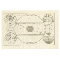
Antique Double Hemisphere World Map with California as an Island, 1710
About the Item
Description: Antique map titled 'De Werelt Caart'. First state (out of three) antique double hemisphere world map from a Dutch bible by Cornelis Dankerts (Danckerts), engraved by Albert Schut, printed in 1710. This map is the first state out of 3 (with 'tot Amsterdam Nieuwelijks uyt Gegeven door Cornelis Dankerts voor aen de Nieuwendyck in den Atlas met Privilege' at bottom left. California is shown as an island and Terra Esonis stretches from just above California nearly to Asia and the land of Yedso above Japan. North and south polar projections appear at the top and bottom between the spheres. In each upper corner are illustrations of Ptolemaic theory on the revolution of the planets and stars around the earth. In the lower corners are diagrams of the movement of the Sun throughout varying degrees of latitude and a plan of the Sun, Moon and Earth during lunar and solar eclipses. There are extensive notations in Dutch at the top and a keyed table of latitude at the bottom. Dutch text on verso.
Artists and Engravers: Cornelis Danckerts II (1603-1656) was a succesful Amsterdam-based art-. print- and map-seller. (He called himself 'Papiere, konst en caertverkoper.') His sons Dancker II and Justus were active in the business as well. The Danckerts were a well known family containing several engravers, cartographers and print-sellers that started with the founder Cornelis Danckerts I (1536-1595) who was the city carpenter.
Condition: Good, given age. Three vertical creases. Edges with a few tiny tears. Original folds as issued. General age-related toning and/or occasional minor defects from handling. Please study image carefully.
- Dimensions:Height: 15.91 in (40.4 cm)Width: 20.71 in (52.6 cm)Depth: 0 in (0.02 mm)
- Materials and Techniques:
- Period:1710-1719
- Date of Manufacture:1710
- Condition:Wear consistent with age and use. Condition: Good, given age. Three vertical creases. Edges with a few tiny tears. Original folds as issued. General age-related toning and/or occasional minor defects from handling. Please study image carefully.
- Seller Location:Langweer, NL
- Reference Number:
About the Seller
5.0
Platinum Seller
These expertly vetted sellers are 1stDibs' most experienced sellers and are rated highest by our customers.
Established in 2009
1stDibs seller since 2017
1,947 sales on 1stDibs
Typical response time: <1 hour
- ShippingRetrieving quote...Ships From: Langweer, Netherlands
- Return PolicyA return for this item may be initiated within 14 days of delivery.
More From This SellerView All
- Antique Map of America with California as an Island by Homann '1710'Located in Langweer, NLThis antique map, titled "Totius Americae Septentrionalis et Meridionalis," represents a significant cartographic piece from 1710 by Johann Baptist Homann. Here's a description of this remarkable map: - **Title**: Totius Americae Septentrionalis et Meridionalis (...) - **Date**: Published in 1710 by Johann Baptist Homann. **Description**: This map is a first edition of Johann Baptiste Homann's map of America, and it is notable for several cartographic features and historical representations: 1. **California as an Island...Category
Antique Early 18th Century Maps
MaterialsPaper
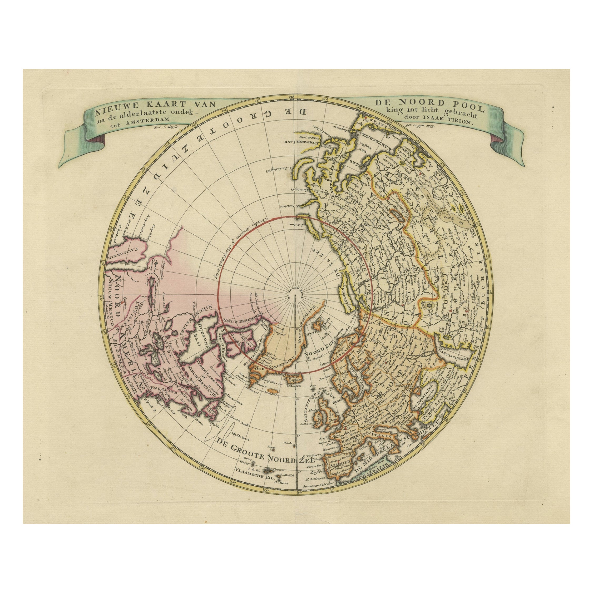
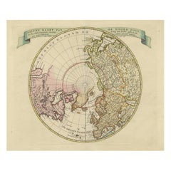
- Beautiful Antique Map of the Northern Hemisphere with California as an IslandBy Isaak TirionLocated in Langweer, NLAntique map titled 'Nieuwe Kaart van de Noord Pool na de alderlaatste ontdekking int licht gebracht tot Amsterdam door Isaak Tirion'. Beautiful map of the Northern Hemisphere and Nor...Category
Antique Mid-18th Century Maps
MaterialsPaper
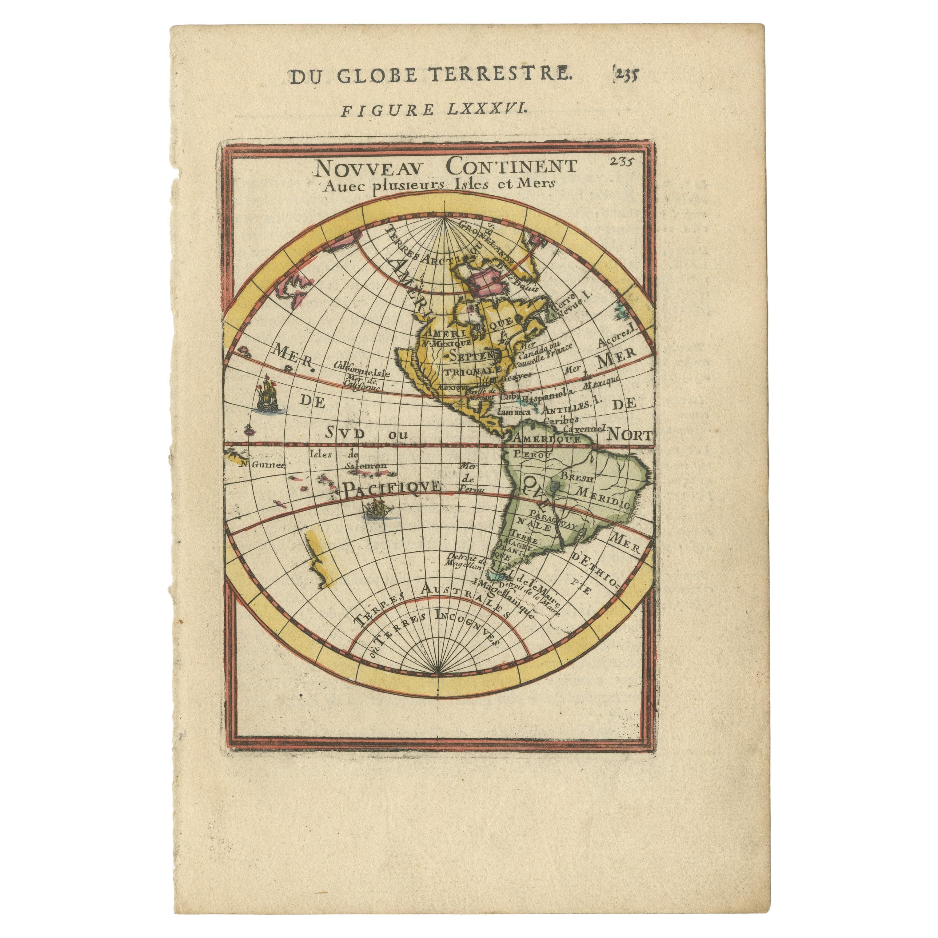
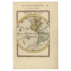
- Antique Miniature Map of the Western Hemisphere, with California as an IslandLocated in Langweer, NLAntique miniature map titled 'Nouveau Continent avec plusieurs Isles et Mers'. Decorative map of the Western Hemisphere, published by Alain Manesson Mallet. The map shows California as an Island...Category
Antique Late 17th Century Maps
MaterialsPaper
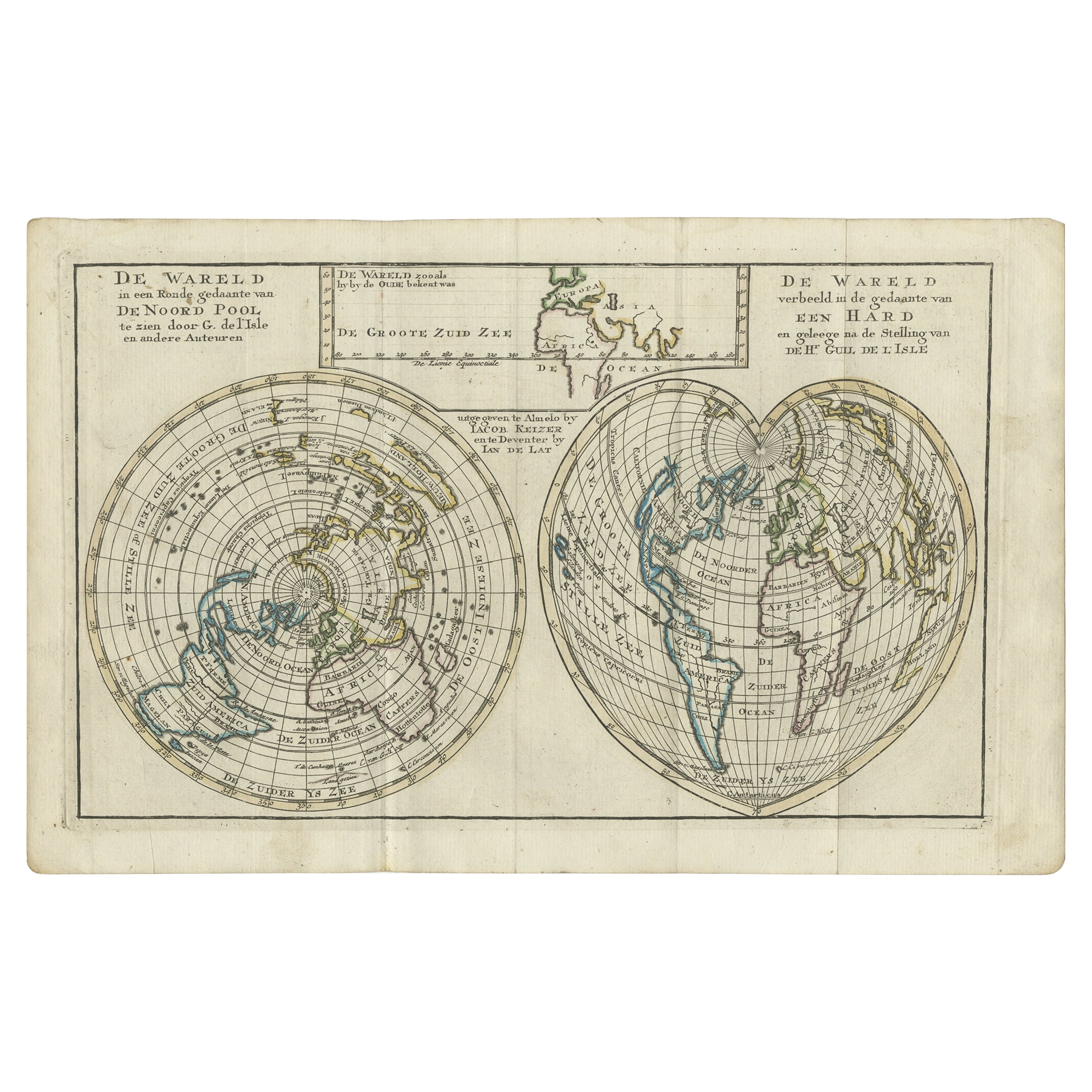
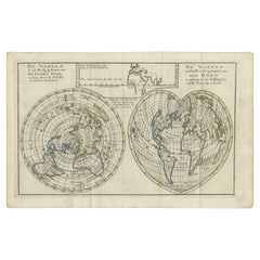
- Antique Map of the World with California as an Island, 1788Located in Langweer, NLDescription: Antique map titled 'De wareld in een ronde gedaante van de Noord Pool te zien - De Wareld verbeeld in de gedaante van een hard'. This interesting composition contains three world maps on the sheet. At left is a northern projection showing all the landmasses. At right is a cordiform projection (heart-shaped). At top is a map of the world as known to the ancients. Both the polar and cordiform projections show California as an island...Category
Antique 1780s Maps
MaterialsPaper
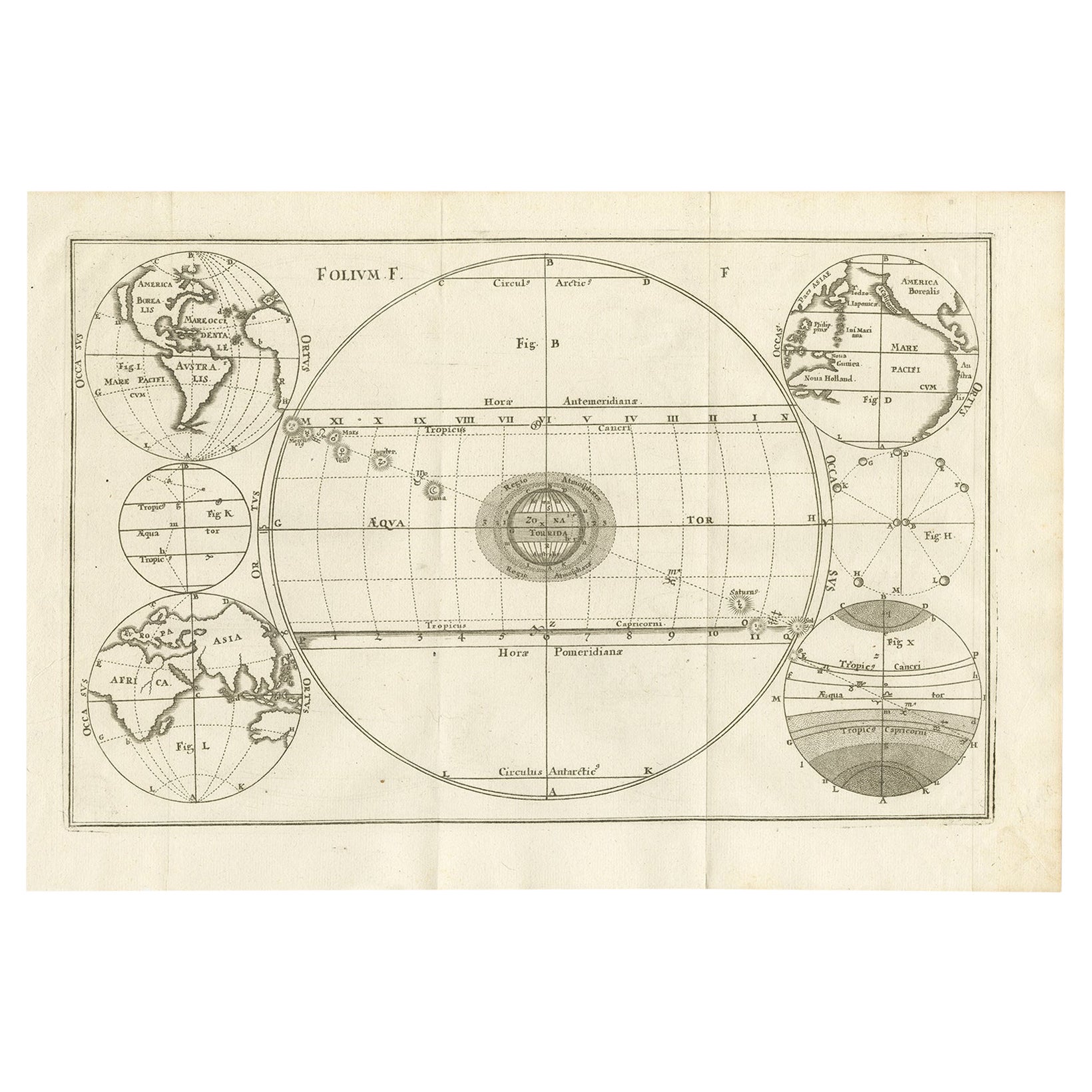
- Unique Antique Projection of the World with Twice California as an Island, c1703Located in Langweer, NLDescription: Antique map of the world. Printed for Scherer's 'Atlas Novus' (1702-1710). On this old engraving you can find California as an Island twice! Rare! Artists and Eng...Category
Antique Early 1700s Maps
MaterialsPaper
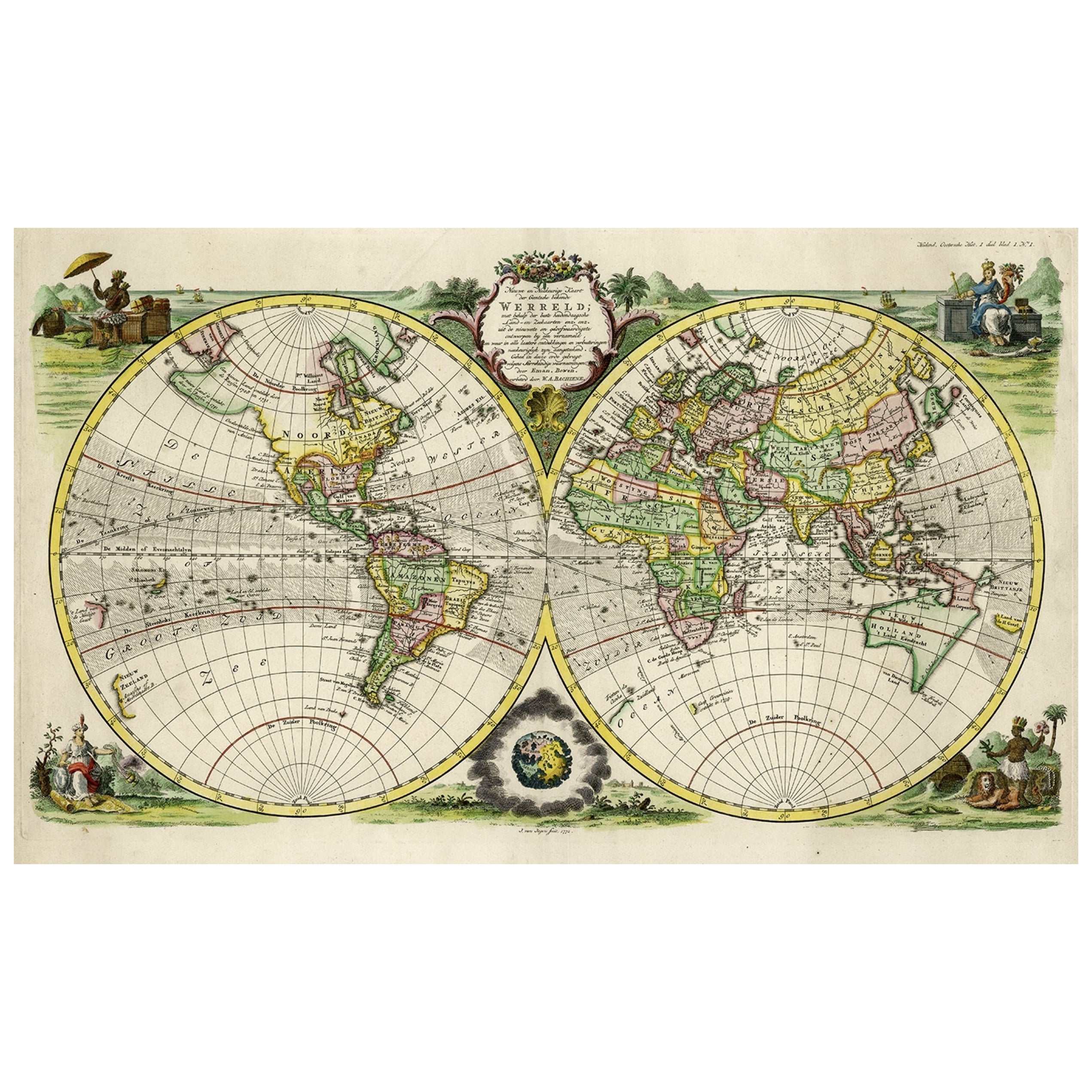
- Rare Original Double Hemisphere World Map with Allegorical Figures, 1785Located in Langweer, NLAntique map titled 'Nieuwe en Naukeurige Kaart der Gantsche bekende Werreld.' A double hemisphere world map. Four allegorical figures in the c...Category
Antique 1780s Maps
MaterialsPaper

You May Also Like
- St. Christophe 'St. Kitts' Island: An 18th Century Hand-colored Map by BellinBy Jacques-Nicolas BellinLocated in Alamo, CAJacques Bellin's copper-plate map of the Caribbean island of Saint Kitts entitled "Carte De De l'Isle St. Christophe Pour servir á l'Histoire Genle. des V...Category
Antique Mid-18th Century French Maps
MaterialsPaper
- Original Antique Map of The World by Thomas Clerk, 1817Located in St Annes, LancashireGreat map of The Eastern and Western Hemispheres On 2 sheets Copper-plate engraving Drawn and engraved by Thomas Clerk, Edinburgh. Published by Mackenzie And Dent, 1817 ...Category
Antique 1810s English Maps
MaterialsPaper
- "San Francisco, Upper California” 1851 Antique Map of San FranciscoLocated in Colorado Springs, COThis is a pictorial lettersheet view of the city and harbor of San Francisco. This lithograph was printed on grey wove paper, across a double sheet, by famed lithographers Britton & ...Category
Antique 1850s American Prints
MaterialsPaper
- Antique Map of Principality of MonacoBy Antonio Vallardi EditoreLocated in Alessandria, PiemonteST/619 - "Old Geographical Atlas of Italy - Topographic map of ex-Principality of Monaco" - ediz Vallardi - Milano - A somewhat special edition ---Category
Antique Late 19th Century Italian Other Prints
MaterialsPaper
- Original Antique Map of Italy. C.1780Located in St Annes, LancashireGreat map of Italy Copper-plate engraving Published C.1780 Unframed.Category
Antique Early 1800s English Georgian Maps
MaterialsPaper

- Original Antique Map of Asia. C.1780Located in St Annes, LancashireGreat map of Asia Copper-plate engraving Published C.1780 Two small worm holes to right side of map Unframed.Category
Antique Early 1800s English Georgian Maps
MaterialsPaper


Recently Viewed
View AllMore Ways To Browse
Sun Moon
Antique Furniture California
Double Door Handle
Antique World Map Print
With Stars And Moons
Antique Spheres
Antique Table Art Collectibles
Antique Table Antiques Art Collectables
Antique Tables Art Collectibles
Antique Doors Art Collectibles
Antique Door Art Collectibles
Antique Carpenters
Antique Japan Doors
Antique State Maps
Antique Carpenters Table
Antique Carpenter Table
Antique Japanese Door
California Map