Items Similar to Rare Original Double Hemisphere World Map with Allegorical Figures, 1785


Want more images or videos?
Request additional images or videos from the seller
1 of 5
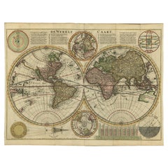
Rare Original Double Hemisphere World Map with Allegorical Figures, 1785
About the Item
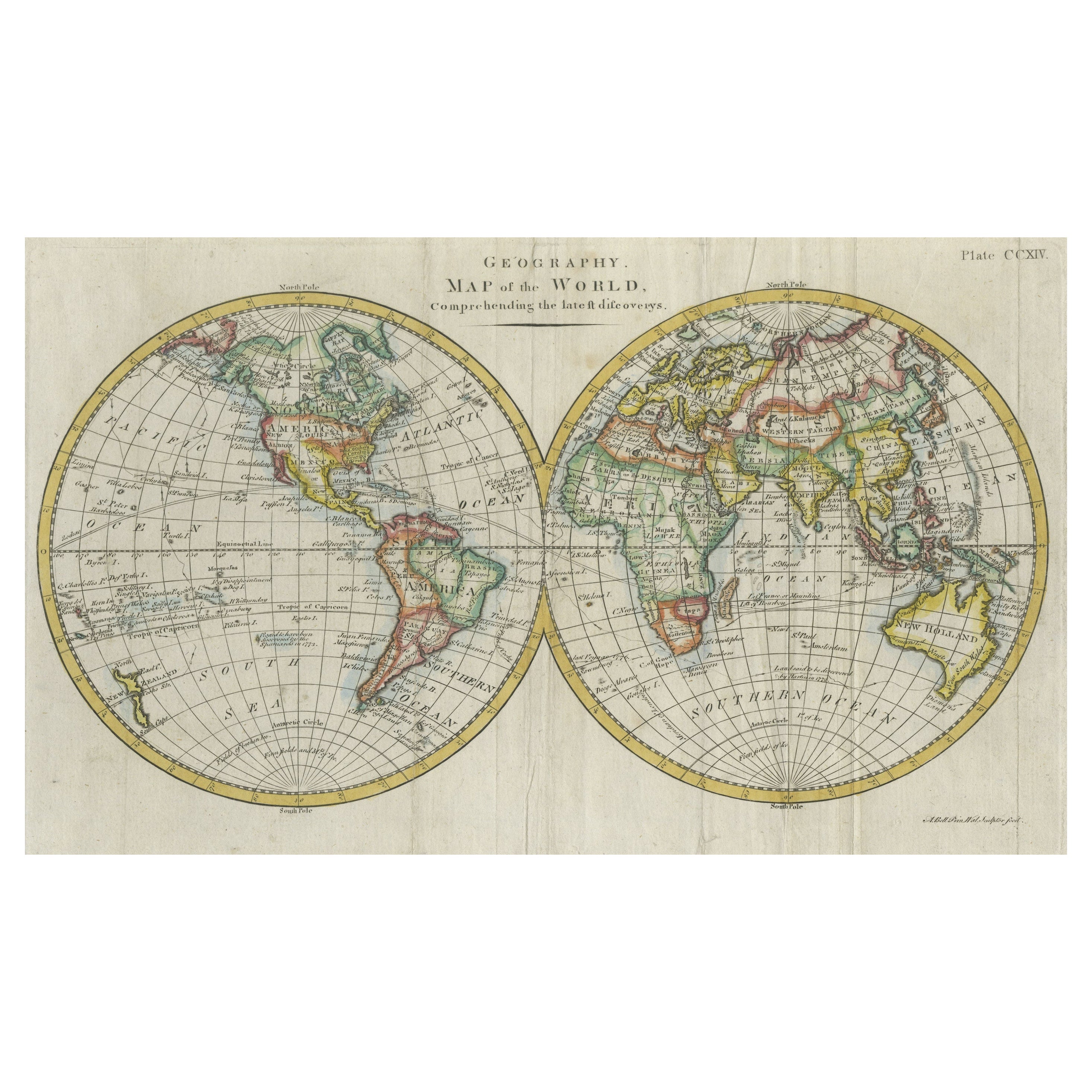
Antique map titled 'Nieuwe en Naukeurige Kaart der Gantsche bekende Werreld.'
A double hemisphere world map. Four allegorical figures in the corners represent Europe, Asia, Africa and America. Small arrows indicate the prevalent ocean current. Rare. The map is dated 1772 in the lower middle. All the maps of Bachiene were published in 1785 by the Amsterdamse publisher Schalekamp under the title "Atlas tot opheldering der Hedendaagsche Historie". The top margin reads: "Hedend. Oostersche Hist. 1 deel blad 1. No. 1". We estimate this map to seperately published, because of the lack of a clear middle fold.
Artists and Engravers: Made by 'J. van Jagen' after 'Eman. Bowen & W.A. Bachiene'. Jan van Jagen (Dutch; ca. 1710-after 1796). Willem Albert Bachiene (1712-1783) was a Dutch preacher, geographer and astronomer. In 1764 he became professor in astronomy and geography at the 'Illustere School' of Maastricht. After 1769 he published maps based on Emanuel Bowen. In 1785 all his maps were published together in the Atlas part of 'Hedendaagsche Historie (...)' by Matthijs Schalekamp in Amsterdam.
- Dimensions:Height: 17.05 in (43.3 cm)Width: 23.23 in (59 cm)Depth: 0 in (0.02 mm)
- Materials and Techniques:
- Period:1780-1789
- Date of Manufacture:1785
- Condition:Condition: Good, given age. Vague foldline in middle. Left and right margin edges uneven (as issued). Margins a little soiled. Tiny pinholes in the lower margin. A few tiny dark stains in the lower margin. Crease at top right.
- Seller Location:Langweer, NL
- Reference Number:
About the Seller
5.0
Platinum Seller
These expertly vetted sellers are 1stDibs' most experienced sellers and are rated highest by our customers.
Established in 2009
1stDibs seller since 2017
1,947 sales on 1stDibs
Typical response time: <1 hour
- ShippingRetrieving quote...Ships From: Langweer, Netherlands
- Return PolicyA return for this item may be initiated within 14 days of delivery.
More From This SellerView All
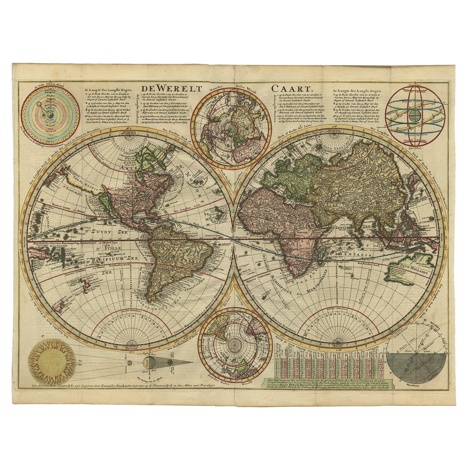
- Antique Double Hemisphere World Map with California as an Island, 1710Located in Langweer, NLDescription: Antique map titled 'De Werelt Caart'. First state (out of three) antique double hemisphere world map from a Dutch bible by Cornelis D...Category
Antique 1710s Maps
MaterialsPaper
- Antique Map of the World in Hemispheres by Johnson, '1872'Located in Langweer, NLAntique map titled 'Johnson's Globular World. Original world map depicting the Eastern Hemisphere and the Western Hemisphere. This map originates fr...Category
Antique Late 19th Century Maps
MaterialsPaper
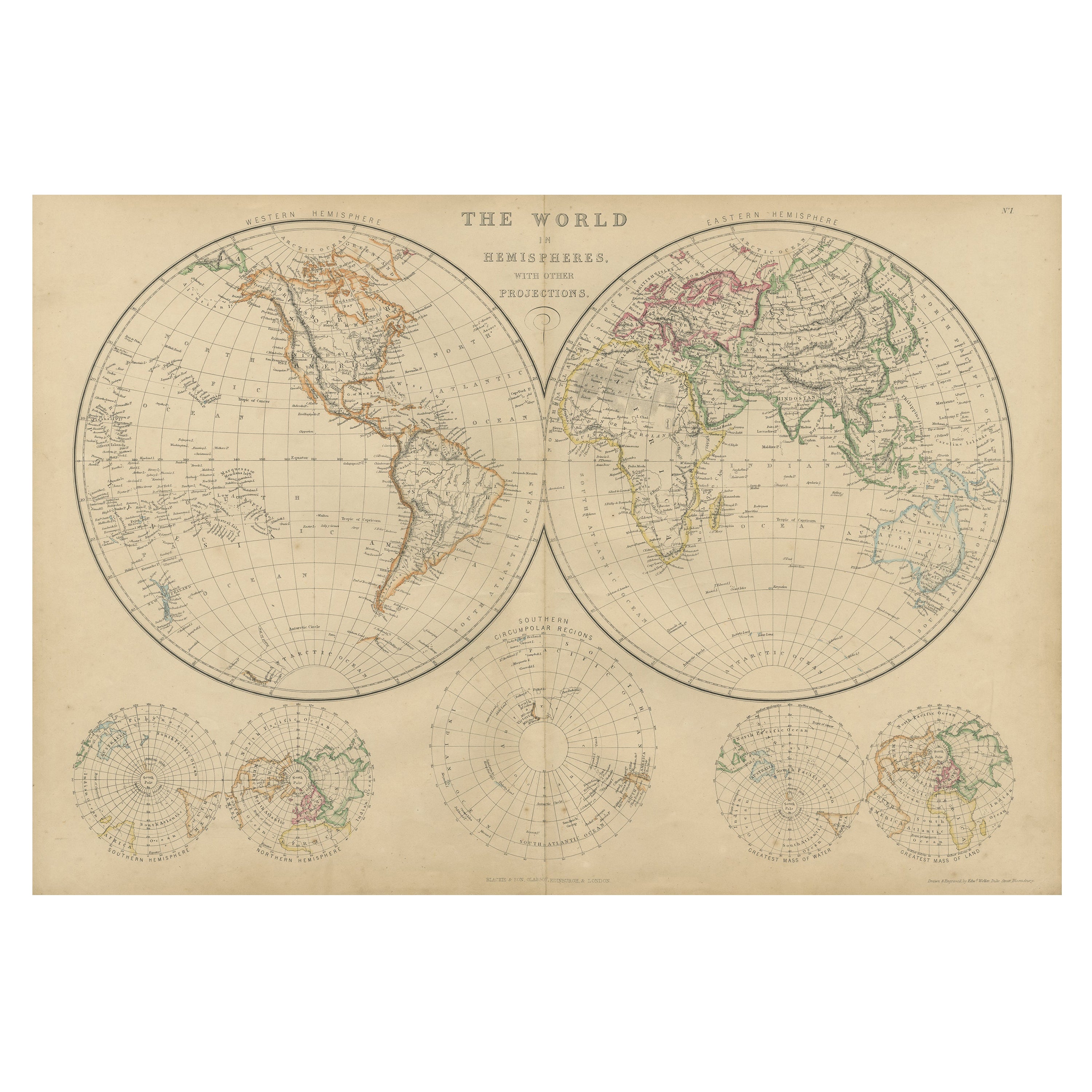
- Antique Map of The World in Hemispheres by W. G. Blackie, 1859Located in Langweer, NLAntique map titled 'The World in Hemispheres with other projections'. Original antique map of The World. This map originates from ‘The Imperial Atlas of Modern Geography’. Published ...Category
Antique Mid-19th Century Maps
MaterialsPaper
- Antique Map of the World in Hemispheres by Keizer & de Lat, 1788Located in Langweer, NLAntique map titled 'Schuine Ronde Aard-Bolle waar van 't Middelpunt is Amsterdam (..)'. Interesting double hemisphere world map on polar projections. In North America, there is a large Island of California. Australia and New Zealand are shown with incomplete coastlines. The map contains six smaller astronomical...Category
Antique Late 18th Century Maps
MaterialsPaper
- Interesting Original Antique Hemisphere Map Showing the Latest DiscoveriesLocated in Langweer, NLAntique world map titled 'A Map of the World from the best Authorities'. Detailed map of the World, showing tracks of Captain James Cook in his 3 voyages in great detail. The map is ...Category
Antique Late 18th Century Maps
MaterialsPaper
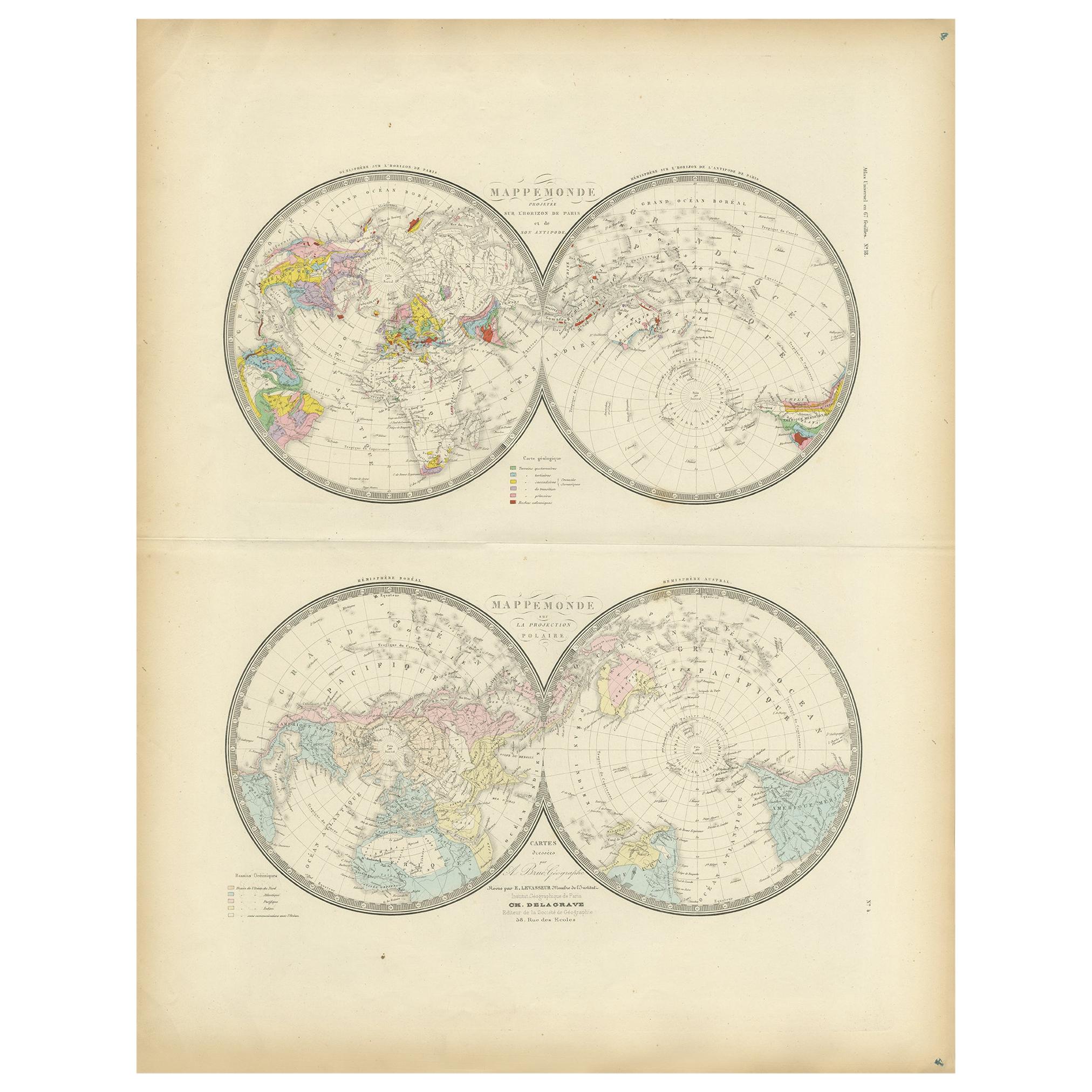
- Antique Hemisphere Map of the World 'Two on One Sheet' by Levasseur, '1875'Located in Langweer, NLAntique map titled 'Mappemonde projetée sur l'Horizon de Paris et de son Antipode - Mappemonde sur la projection polaire'. Large map with two hemisphere world maps...Category
Antique Late 19th Century Maps
MaterialsPaper


You May Also Like
- Original Antique Map of The World by Thomas Clerk, 1817Located in St Annes, LancashireGreat map of The Eastern and Western Hemispheres On 2 sheets Copper-plate engraving Drawn and engraved by Thomas Clerk, Edinburgh. Published by Mackenzie And Dent, 1817 ...Category
Antique 1810s English Maps
MaterialsPaper
- Original Antique Map of Italy. C.1780Located in St Annes, LancashireGreat map of Italy Copper-plate engraving Published C.1780 Unframed.Category
Antique Early 1800s English Georgian Maps
MaterialsPaper

- Original Antique Map of Asia. C.1780Located in St Annes, LancashireGreat map of Asia Copper-plate engraving Published C.1780 Two small worm holes to right side of map Unframed.Category
Antique Early 1800s English Georgian Maps
MaterialsPaper

- Original Antique Map of India. C.1780Located in St Annes, LancashireGreat map of India Copper-plate engraving Published C.1780 Three small worm holes to right side of map and one bottom left corner Unframed.Category
Antique Early 1800s English Georgian Maps
MaterialsPaper

- Original Antique Map of Italy. Arrowsmith. 1820Located in St Annes, LancashireGreat map of Italy Drawn under the direction of Arrowsmith Copper-plate engraving Published by Longman, Hurst, Rees, Orme and Brown, 1820 Unframed.Category
Antique 1820s English Maps
MaterialsPaper
- Original Antique Map of Ireland- Kerry. C.1840Located in St Annes, LancashireGreat map of Kerry Steel engraving Drawn under the direction of A.Adlard Published by How and Parsons, C.1840 Unframed.Category
Antique 1840s English Maps
MaterialsPaper


Recently Viewed
View AllMore Ways To Browse
Antique African Figures
Dutch School Antique
African American Collectibles
Antique Ocean Map
Antique School Map
Antique School Maps
Amsterdamse School
Hemispheres Map
Hemisphere Antiques
Antique Africa Maps And Atlases Africa Maps
Albert Willem
Antique Hemisphere Maps
Amsterdam Amsterdamse
Amsterdamse Amsterdam School
Asian Arrow
Hemisphere World Map
1785 Maps
Wood Carvings Of Ships