Items Similar to Antique Map of Ambon with Inset of the Victoria Castle, Moluku, Indonesia, 1726


Want more images or videos?
Request additional images or videos from the seller
1 of 5
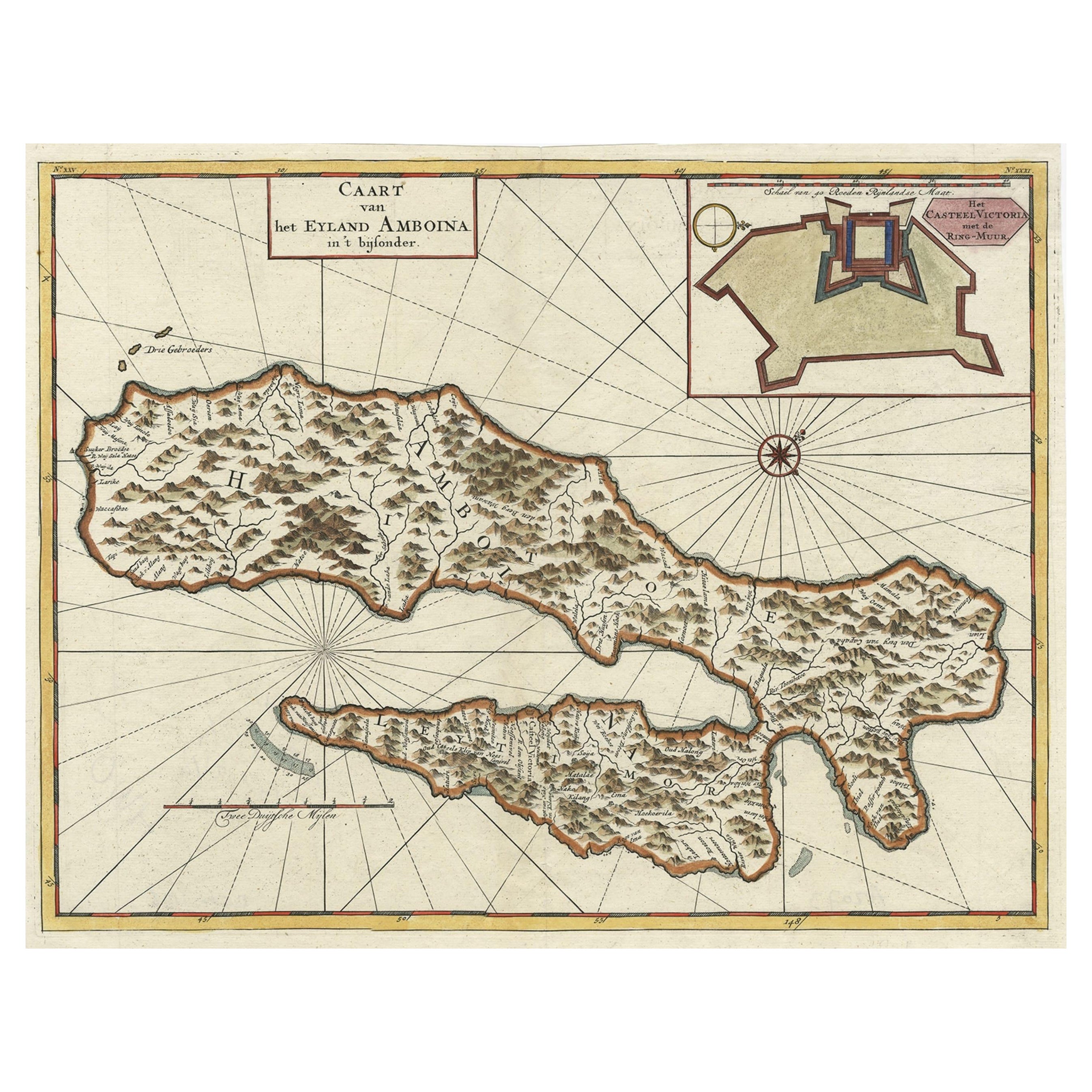
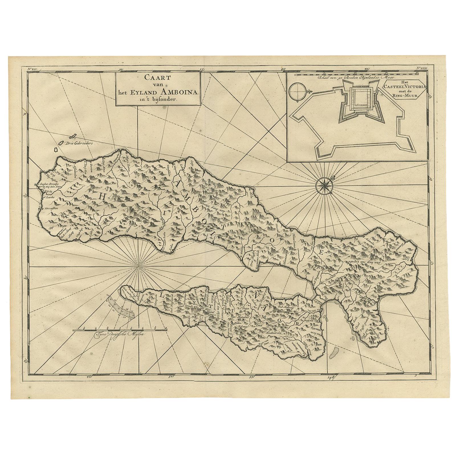
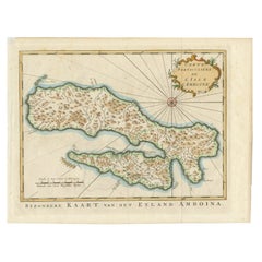
Antique Map of Ambon with Inset of the Victoria Castle, Moluku, Indonesia, 1726
About the Item
Antique map titled 'Caart van het Eyland Ambonia in het bijsonder. ' This is a print of an antique map of the Islands Ambon and Timor, one of the Moluccan Islands, Indonesia, with an inset of castle Victoria with the ring wall. From the monumental: ""Oud en Nieuw Oost-Indiën ..."" by François Valentyn / Valentijn, published in 1724-1726. VOC.
Artists and Engravers: The author François Valentijn (1666-1727), was a Dutch missionary, worked at Amboina from 1684 to 1694 and 1705 to 1713 and traveled extensively in the VOC's lands.
Condition: Very good, given age. Original folds, as issued. General age-related toning and/or occasional minor defects from handling. Please study image carefully.
Date: 1726
Overall size: 47 x 39.3 cm.
Image size: 41.9 x 31.7 cm.
We sell original antique maps to collectors, historians, educators and interior decorators all over the world. Our collection includes a wide range of authentic antique maps from the 16th to the 20th centuries. Buying and collecting antique maps is a tradition that goes back hundreds of years. Antique maps have proved a richly rewarding investment over the past decade, thanks to a growing appreciation of their unique historical appeal. Today the decorative qualities of antique maps are widely recognized by interior designers who appreciate their beauty and design flexibility. Depending on the individual map, presentation, and context, a rare or antique map can be modern, traditional, abstract, figurative, serious or whimsical. We offer a wide range of authentic antique maps for any budget.
- Dimensions:Height: 15.48 in (39.3 cm)Width: 18.51 in (47 cm)Depth: 0 in (0.01 mm)
- Materials and Techniques:
- Period:
- Date of Manufacture:1726
- Condition:
- Seller Location:Langweer, NL
- Reference Number:
About the Seller
5.0
Platinum Seller
These expertly vetted sellers are 1stDibs' most experienced sellers and are rated highest by our customers.
Established in 2009
1stDibs seller since 2017
1,946 sales on 1stDibs
Typical response time: <1 hour
- ShippingRetrieving quote...Ships From: Langweer, Netherlands
- Return PolicyA return for this item may be initiated within 14 days of delivery.
More From This SellerView All
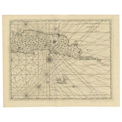
- Antique Map of Ambon Island, Indonesia with Inset of Castle Victoria, 1726Located in Langweer, NLAntique map titled 'Caart van het Eyland Amboina (..).' Detailed map of the Ambon Island and Timor, Molucca Islands, by Francois Valentyn. With an inset of castle Victoria. This map ...Category
Antique 18th Century Maps
MaterialsPaper
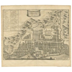
- Antique Map of the City of Ambon by Valentijn, 1726By F. ValentijnLocated in Langweer, NLAntique map titled 'De Platte Grond van Amboina zoo als het was in den Jaare, 1718'. Antique map depicting the City of Ambon, Indonesia. This print originates from 'Oud en Nieuw Oost...Category
Antique Early 18th Century Dutch Maps
MaterialsPaper
- Antique Map of Ambon Island by Valentijn, 1726By F. ValentijnLocated in Langweer, NLAntique map titled 'Caart van het Eyland Amboina in 't bijsonder'. Map of the Islands Ambon and Timor, one of the Moluccan Islands, Indonesia, with an inset of castle Victoria with t...Category
Antique Early 18th Century Dutch Maps
MaterialsPaper
- Antique Map of Ambon Island, Indonesia, 1756Located in Langweer, NLAntique map titled ‘Carte particuliere de l'Isle d'Amboine - Byzondere kaart van het eyland Amboina’. Antique map of the island of Ambon, Indonesia. This map originates from 'Histori...Category
Antique 18th Century Maps
MaterialsPaper
- Antique Map of Ambon and Surroundings by Valentijn '1726'By F. ValentijnLocated in Langweer, NLAntique map titled 'De landvoogdy van Amboina met de elf onderhoorige Eylanden'. Decorative map of the eastern tip of the islands of Ambon, Indonesia. This print originates from 'Oud...Category
Antique Early 18th Century Dutch Maps
MaterialsPaper
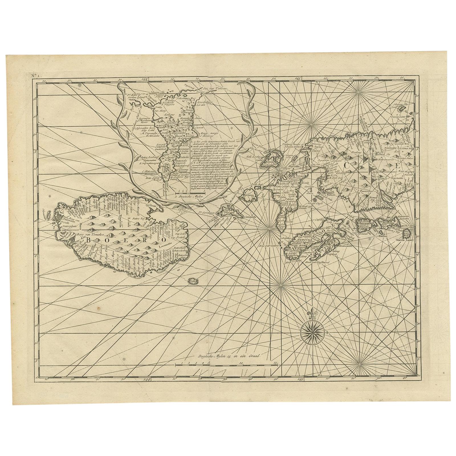
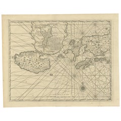
- Antique Map of Ambon and Boero by Valentijn, 1726By F. ValentijnLocated in Langweer, NLUntitled map of the western part of the island Amboina with Boero, Indonesia. This print originates from 'Oud en Nieuw Oost-Indiën' by F. Valentijn.Category
Antique Early 18th Century Dutch Maps
MaterialsPaper

You May Also Like
- 1861 Topographical Map of the District of Columbia, by Boschke, Antique MapLocated in Colorado Springs, COPresented is an original map of Albert Boschke's extremely sought-after "Topographical Map of the District of Columbia Surveyed in the Years 1856 ...Category
Antique 1860s American Historical Memorabilia
MaterialsPaper
- The Indonesian TableLocated in New York City, NY‘It is truly remarkable for a talented chef to also be a sensational storyteller … Petty takes you on a journey across the archipelago, through her food and her life.’ – Julien Royer...Category
21st Century and Contemporary Chinese Books
MaterialsPaper
- Original Antique Map of the American State of Pennsylvania, 1889Located in St Annes, LancashireGreat map of Pennsylvania Drawn and Engraved by W. & A.K. Johnston Published By A & C Black, Edinburgh. Original colour Unframed. Repair to a minor tear on bottom edge.Category
Antique 1880s Scottish Victorian Maps
MaterialsPaper
- Original Antique Map of the American State of Oregon, 1889Located in St Annes, LancashireGreat map of Oregon Drawn and Engraved by W. & A.K. Johnston Published By A & C Black, Edinburgh. Original colour Unframed.Category
Antique 1880s Scottish Victorian Maps
MaterialsPaper
- Original Antique Map of the American State of Washington, 1889Located in St Annes, LancashireGreat map of Washington Drawn and Engraved by W. & A.K. Johnston Published By A & C Black, Edinburgh. Original colour Unframed.Category
Antique 1880s Scottish Victorian Maps
MaterialsPaper
- Original Antique Map of the American State of Nevada, 1889Located in St Annes, LancashireGreat map of Nevada Drawn and Engraved by W. & A.K. Johnston Published By A & C Black, Edinburgh. Original colour Unframed.Category
Antique 1880s Scottish Victorian Maps
MaterialsPaper


Recently Viewed
View AllMore Ways To Browse
Furniture Used Victoria
Used Victoria Furniture
Used Furniture In Victoria
Map Wall
Victoria Antique Furniture
Castle Antiques
Used Victoria Antiques
Antiques From Castle
Castle 18th
Antique Wall Map
Antique Wall Maps
Used Victoria Furniture Antiques
Used Victoria Antique Furniture
Inset Ring
World Map Wall
Timor Indonesia
Antique Wall World Map
Antique Wall Maps Of The World