Items Similar to Antique Map of Asia by Ferrario '1815'


Want more images or videos?
Request additional images or videos from the seller
Antique Map of Asia by Ferrario '1815'
About the Item
Antique map titled 'Carta generale dell' Asia (..)'. Original antique map of Asia. This map originates from ' Le Costume Ancien et Moderne' by Jules Ferrario. Published 1815.
- Dimensions:Height: 20.87 in (53 cm)Width: 29.14 in (74 cm)Depth: 0.02 in (0.5 mm)
- Materials and Techniques:
- Period:
- Date of Manufacture:1815
- Condition:Beautiful coloring. Library blindstamp. General age-related toning, original folding lines. Minor wear and light creasing, blank verso. Few small splits, sl. affecting image. Please study images carefully.
- Seller Location:Langweer, NL
- Reference Number:
About the Seller
5.0
Platinum Seller
These expertly vetted sellers are 1stDibs' most experienced sellers and are rated highest by our customers.
Established in 2009
1stDibs seller since 2017
1,953 sales on 1stDibs
Typical response time: <1 hour
- ShippingRetrieving quote...Ships From: Langweer, Netherlands
- Return PolicyA return for this item may be initiated within 14 days of delivery.
More From This SellerView All
- Antique Map of the World by Ferrario '1831'Located in Langweer, NLOriginal antique map of the world. This print originates from 'Costume Antico e Moderno: Palestine, China, India, Oceania' by Ferrario. Publis...Category
Antique Mid-19th Century Prints
MaterialsPaper
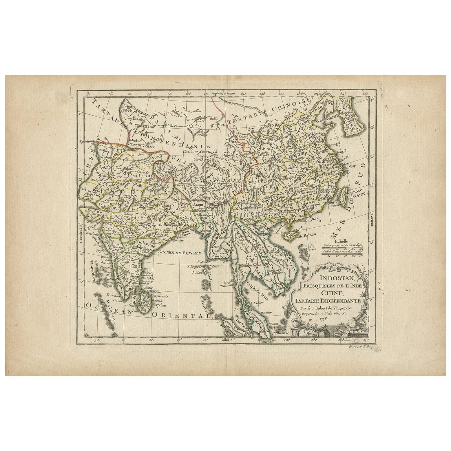
- Antique Map of Asia by Dussy, 1778Located in Langweer, NLAntique map of Asia titled 'Indostan presqu'isles de l'Inde, Chine, Tartarie Independante'. Depicting South-East Asia including Hindustan, India an...Category
Antique Late 18th Century French Maps
MaterialsPaper
- Antique Map of Asia by Lapie, 1842Located in Langweer, NLAntique map titled 'Carte de l'Asie'. Map of Asia. This map originates from 'Atlas universel de géographie ancienne et moderne (..)' by Pierre M. Lapie and...Category
Antique Mid-19th Century Maps
MaterialsPaper
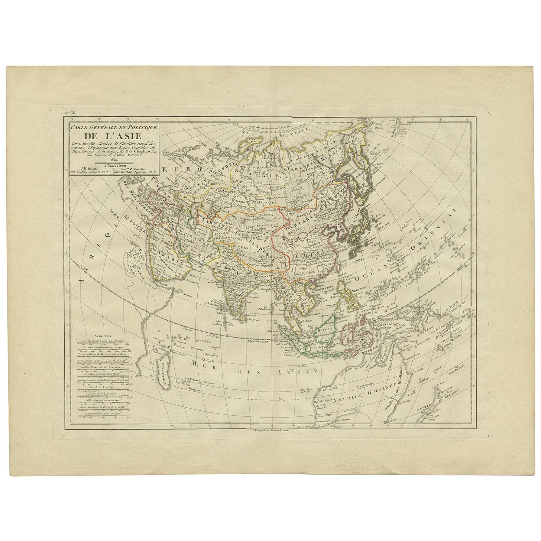
- Antique Map of Asia by Mentelle '1819'Located in Langweer, NLAntique map titled 'Carte générale et Politique de l'Asie'. Detailed map of Asia. Includes a nice early depiction of Australia (Nouvelle Hollande), including its unknown and conjectu...Category
Antique Early 19th Century Maps
MaterialsPaper
- Antique Map of Asia by Johnson, 1872Located in Langweer, NLAntique map titled 'Johnson's Asia'. Original map of Asia. This map originates from 'Johnson's New Illustrated Family Atlas of the World' by A.J. Johnson. Published, 1872.Category
Antique Late 19th Century Maps
MaterialsPaper
- Antique Map of Asia by Wyld '1845'Located in Langweer, NLAntique map titled 'Asia'. Original antique map of Asia. This map originates from 'An Atlas of the World, Comprehending Separate Maps of its Variou...Category
Antique Mid-19th Century Maps
MaterialsPaper


You May Also Like
- Original Antique Map of Asia. C.1780Located in St Annes, LancashireGreat map of Asia Copper-plate engraving Published C.1780 Two small worm holes to right side of map Unframed.Category
Antique Early 1800s English Georgian Maps
MaterialsPaper

- Original Antique Map of South East Asia by Thomas Clerk, 1817Located in St Annes, LancashireGreat map of South East Asia Copper-plate engraving Drawn and engraved by Thomas Clerk, Edinburgh. Published by Mackenzie And Dent, 1817 Unframed.Category
Antique 1810s English Maps
MaterialsPaper
- Original Antique Map of South East Asia by Becker, circa 1840Located in St Annes, LancashireGreat map of South East Asia Steel engraving with original color outline Engraved by Becker Published by Virtue, circa 1840. Unframed.Category
Antique 1840s English Other Maps
MaterialsPaper
- Original Antique Map of South East Asia, Arrowsmith, 1820Located in St Annes, LancashireGreat map of South East Asia Drawn under the direction of Arrowsmith Copper-plate engraving Published by Longman, Hurst, Rees, Orme and Brown, 1820 Unframed.Category
Antique 1820s English Maps
MaterialsPaper
- Antique Map of Italy by Andriveau-Goujon, 1843By Andriveau-GoujonLocated in New York, NYAntique Map of Italy by Andriveau-Goujon, 1843. Map of Italy in two parts by Andriveau-Goujon for the Library of Prince Carini at Palazzo Carini i...Category
Antique 1840s French Maps
MaterialsLinen, Paper
- Antique Map of Principality of MonacoBy Antonio Vallardi EditoreLocated in Alessandria, PiemonteST/619 - "Old Geographical Atlas of Italy - Topographic map of ex-Principality of Monaco" - ediz Vallardi - Milano - A somewhat special edition ---Category
Antique Late 19th Century Italian Other Prints
MaterialsPaper


