Items Similar to Antique Map of Bavaria in Southern Germany and Austria, 1806

Want more images or videos?
Request additional images or videos from the seller
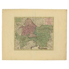
Antique Map of Bavaria in Southern Germany and Austria, 1806
About the Item
Antique map titled 'Cercles de Baviere et d'Autriche.' This map shows Bavaria in southern Germany and Austria. By Robert de Vaugondy, revised and published by Delamarche. Source unknown, to be determined.
Artists and Engravers: Charles Francois Delamarche (1740-1817) founded the important and prolific Paris based Maison Delamarche map publishing firm in the late 18th century. A lawyer by trade Delamarche entered the map business with the acquisition from Jean-Baptiste Fortin of Robert de Vaugondy's map plates and copyrights and later addes many plates from other sources as well. Charles Delamarche eventually passed control of the firm to his son Felix Delamarche (18th C. - 1st half 19th C.) and geographer Charles Dien (1809-1870). It was later passed on to Alexandre Delamarche, who revised and reissued several Delamarche publications in the mid-19th century. The firm continued to publish maps and globes until the middle part of the 19th century.
Condition: Good, given age. Original middle fold as issued. General age-related toning and/or occasional minor defects from handling. Please study image carefully.
Date: 1806
Overall size: 33.5 x 28.3 cm.
Image size: 24 x 28.2 cm.
- Dimensions:Height: 11.15 in (28.3 cm)Width: 13.19 in (33.5 cm)Depth: 0 in (0.01 mm)
- Materials and Techniques:
- Period:
- Date of Manufacture:1806
- Condition:
- Seller Location:Langweer, NL
- Reference Number:
About the Seller
5.0
Platinum Seller
These expertly vetted sellers are 1stDibs' most experienced sellers and are rated highest by our customers.
Established in 2009
1stDibs seller since 2017
1,949 sales on 1stDibs
Typical response time: <1 hour
- ShippingRetrieving quote...Ships From: Langweer, Netherlands
- Return PolicyA return for this item may be initiated within 14 days of delivery.
More From This SellerView All
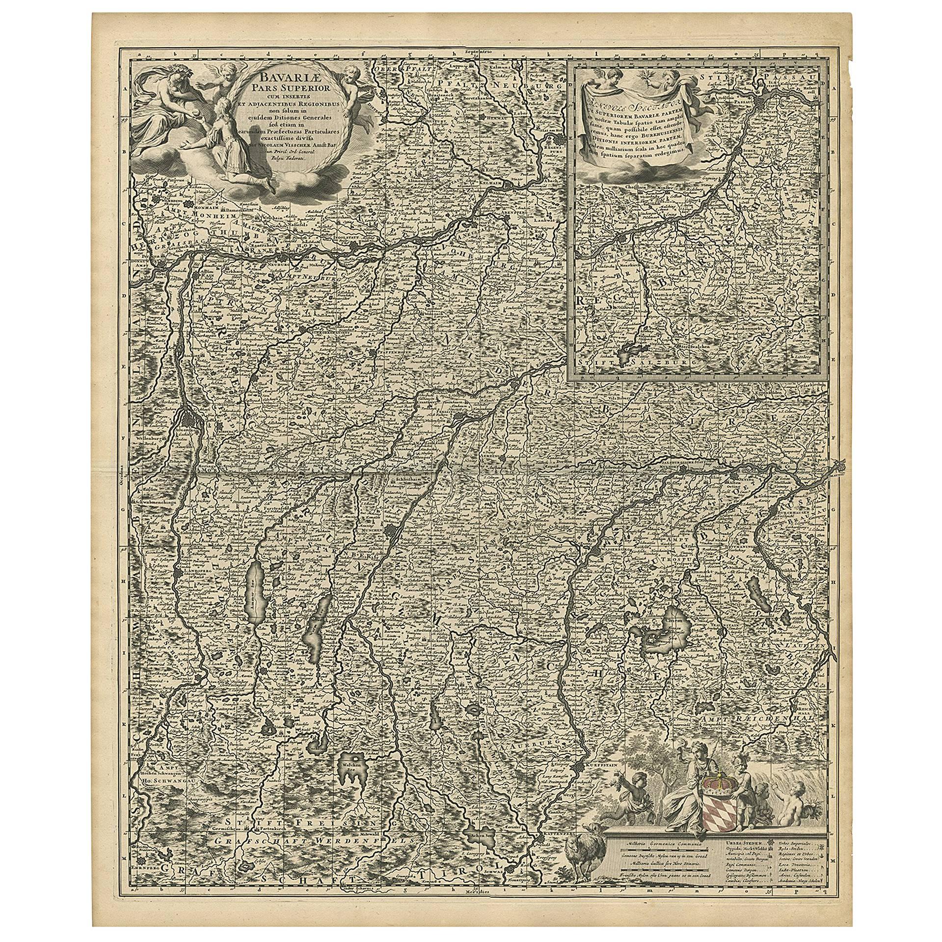
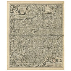
- Antique Map of Upper Bavaria, GermanyLocated in Langweer, NLAntique map titled 'Bavariae pars superior cum insertis et adjacentibus regionibus non solum in ejusdem ditiones generales (..). Original antique map of upper Bavaria from Regensburg...Category
Antique Late 17th Century Maps
MaterialsPaper
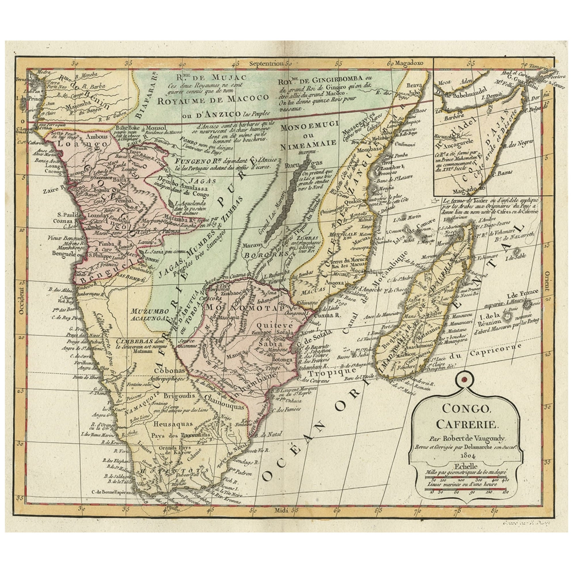
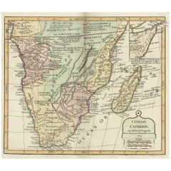
- Decorative Antique Map of the Southern Part of Africa, 1806Located in Langweer, NLAntique map titled 'Congo, Cafrerie.' Decorative map of the southern part of Africa by Robert de Vaugondy, revised and published by Delamarche. Source unknown, to be determined. Artists and Engravers: Charles Francois Delamarche (1740-1817) founded the important and prolific Paris based Maison Delamarche map publishing firm in the late 18th century. A lawyer by trade Delamarche entered the map business with the acquisition from Jean-Baptiste Fortin of Robert de Vaugondy's map plates...Category
Antique Early 1800s Maps
MaterialsPaper
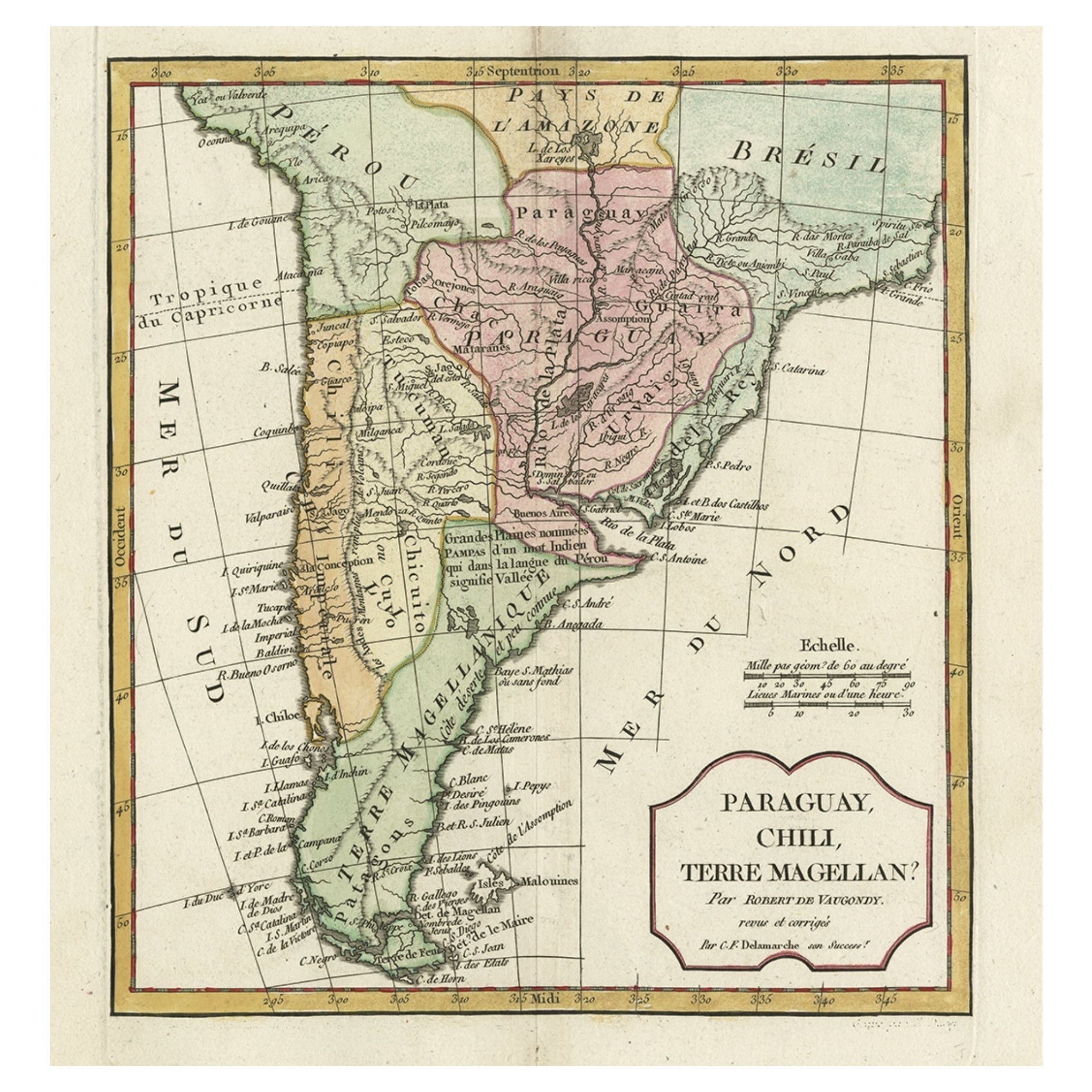
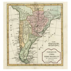
- Decorative Antique Map of the Southern Part of South America, 1806Located in Langweer, NLDescription: Antique map titled 'Paraguay, Chili, Terre Magellan?' Decorative map of the southern part of South America by Robert de Vaugondy, revised and published by Delamarche. Source unknown, to be determined. Artists and Engravers: Charles Francois Delamarche (1740-1817) founded the important and prolific Paris based Maison Delamarche map publishing firm in the late 18th century. A lawyer by trade Delamarche entered the map business with the acquisition from Jean-Baptiste Fortin of Robert de Vaugondy's map plates...Category
Antique Early 1800s Maps
MaterialsPaper
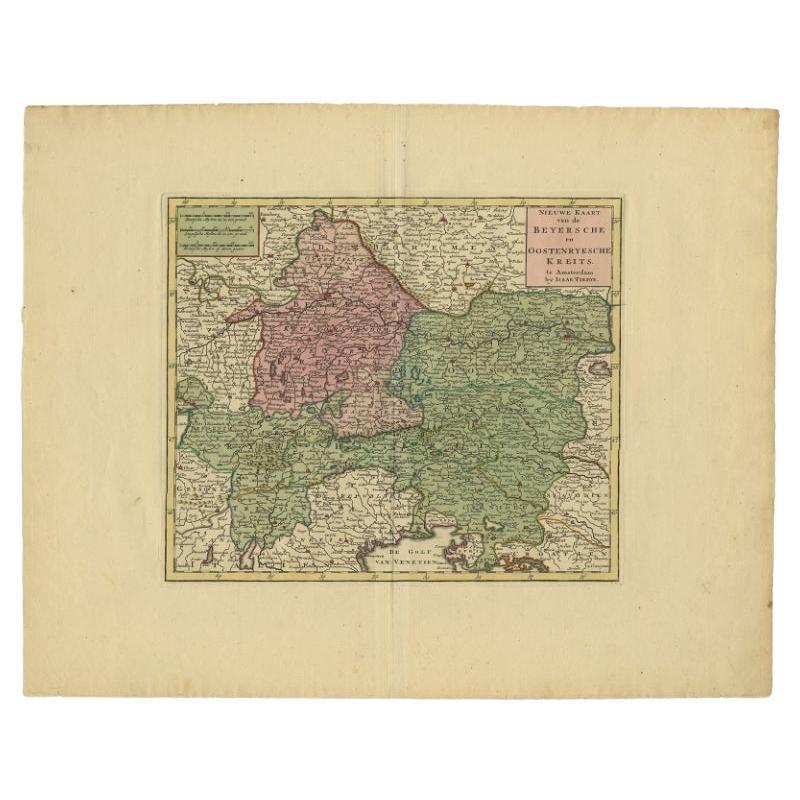
- Attractive Detailed Authentic Map Showing Bavaria, Germany and Austria, c.1740Located in Langweer, NLAntique map titled 'Nieuwe Kaart van de Beyersche en Oostenryksche Kreits (..).' Attractive detailed map showing Bavaria, Germany and Austria. Source unknown, to be determined. Ar...Category
Antique 18th Century Maps
MaterialsPaper
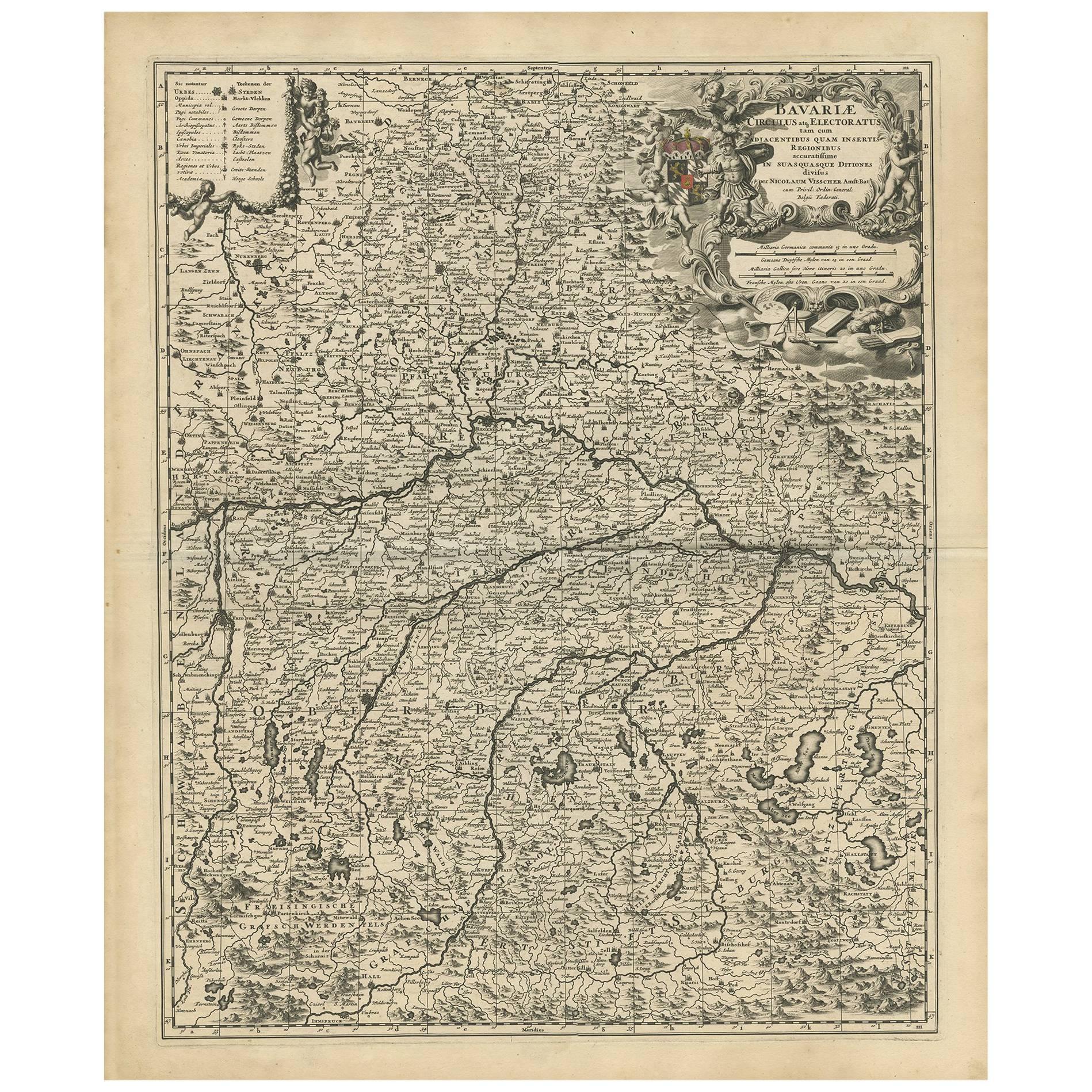
- Antique Map of Bavaria with many details, GermanyLocated in Langweer, NLAntique map titled 'Bavariae Circulus atq Electoratus tam cum Adiacentibus quam insertis Regionibus (..)'. Dutch map of Bavaria, showing the many cities, towns, and other features of...Category
Antique Late 17th Century Maps
MaterialsPaper
- Decorative Original Antique Map of Southern Germany, c.1730Located in Langweer, NL"Antique map titled 'The South West Part of Germany. Containing ye Dominions of the Archbishops and Electors of Mentz Y Treves, and of ye Elec. Palatine of ye Rhine; with Franconia, ...Category
Antique 18th Century Maps
MaterialsPaper

You May Also Like
- Original Antique Map of Spain and Portugal, Engraved By Barlow, 1806Located in St Annes, LancashireGreat map of Spain And Portugal Copper-plate engraving by Barlow Published by Brightly & Kinnersly, Bungay, Suffolk. 1806 Unframed.Category
Antique Early 1800s English Maps
MaterialsPaper
- East German MapBy VEB Hermann HaackLocated in Baltimore, MDA brilliantly colourful map of the Leipzig, Karl Marx Stadt and Dresden area in the former German Democratic Republic by VEB Hermann Haack of Gotha.Category
Vintage 1970s German Maps
- Antique Pair of English Maritime Colored Etchings 1806.Located in Vero Beach, FLAntique Pair of English Maritime Colored Etchings 1806. English hand-colored etchings of a 90 Gun Ship at Spithead and a Collier with a view of the S...Category
Antique 19th Century English Romantic Nautical Objects
MaterialsGlass, Giltwood, Paper
- Antique Handcrafted German Railroad / Train Station Ticket Booth By Bing BavariaLocated in Lisse, NLVery rare and great looking antique toy train ticket dispenser by Gebruder Bing, Nurnberg (GBN). Since buying and selling only the rarest antiques h...Category
Early 20th Century German Arts and Crafts Toys and Dolls
MaterialsMetal
- Set of 4 Antique Geographical Maps French-German War 1870-71Located in Casale Monferrato, ITElegant late 19th century set of four antique geographical maps relating to the positioning of the armies in the Franco-German War 1870-71. A...Category
Antique 1890s Italian Maps
MaterialsPaper
- Map Southern Scotland Thomas Conder Alex Hogg 1795Located in BUNGAY, SUFFOLKA new map of the southern part of Scotland containing the counties of Stirling, Lanerk, Renfrew, Linlithgow, Edinburgh, Peebles, Haddingtoun, Berwick, Selkirk, Roxburgh, Dumfries, Wigtoun, Kirkudbright & Air Published by Alex Hogg at the Kings Arms...Category
Antique 18th Century English Georgian Maps
MaterialsPaper


Recently Viewed
View AllMore Ways To Browse
Southern Antiques
19th Century German Collectibles
Southern Germany
Bavaria Antique
Austrian And German Antique Furniture
Lawyer Office
German 18th C
Maison Charles Of Paris
18th Century Southern Antiques
Antique Maps And Globes
Antique Globes And Maps
Antique Paper Globe
Antique Lawyer
Antique Map Globe
Bavaria Plate
Map Austria
Map Of Austria
Maison Jean Charles