Items Similar to Antique Map of the Bay of Manila, Capital of the Philippines


Want more images or videos?
Request additional images or videos from the seller
1 of 7
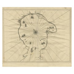
Antique Map of the Bay of Manila, Capital of the Philippines
About the Item
Antique map titled 'Abzeichnung des Meerbusens bey Manila'. Map of the Bay of Manila, capital of the Philippines. This map originates from a German edition of 'Voyage around the World' by Lord George Anson. Published 1763.
- Dimensions:Height: 8.47 in (21.5 cm)Width: 10.63 in (27 cm)Depth: 0.02 in (0.5 mm)
- Materials and Techniques:
- Period:
- Date of Manufacture:1763
- Condition:Wear consistent with age and use. General age-related toning. Thin paper, partly trimmed. Original folding lines. Few small tears, slightly affecting image. Blank verso, please study images carefully.
- Seller Location:Langweer, NL
- Reference Number:Seller: BG-12934-31stDibs: LU3054331065382
About the Seller
5.0
Platinum Seller
These expertly vetted sellers are 1stDibs' most experienced sellers and are rated highest by our customers.
Established in 2009
1stDibs seller since 2017
1,947 sales on 1stDibs
Typical response time: <1 hour
- ShippingRetrieving quote...Ships From: Langweer, Netherlands
- Return PolicyA return for this item may be initiated within 14 days of delivery.
Auctions on 1stDibs
Our timed auctions are an opportunity to bid on extraordinary design. We do not charge a Buyer's Premium and shipping is facilitated by 1stDibs and/or the seller. Plus, all auction purchases are covered by our comprehensive Buyer Protection. Learn More
More From This SellerView All
- Antique Engraved Map of Manila, the Earliest Obtainable Map of Manila Bay, 1726Located in Langweer, NLAntique map titled 'Manilhas Bay'. This map is considered the earliest obtainable map of Manila Bay. Depicts Manila Bay, locating the city of Manila, Castle (Cabitta), Cloister of Sa...Category
Antique 18th Century Maps
MaterialsPaper
- Antique Map of Manilla Bay Philippines by P. van der Aa, 1719Located in Langweer, NLRare antique map titled 'La Baie de Manille (..)'. Map of Manilla Bay, the map is oriented with southwest at the top and includes a small town plan for Manilla and other places. This...Category
Antique Early 18th Century Maps
MaterialsPaper
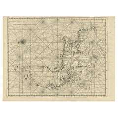
- Antique Map of the Philippines by Anson '1749'Located in Langweer, NLAntique map titled 'Carte du Canal des Iles Philippines - Kaart van het Kanaal in de Filippynsche Eilanden'. Large detailed chart of the islands of the Philippines. One of the most detailed charts of the Philippines of the era. Shows Islands, bays, reefs, soundings tracks of the Manila Galleon route, etc. Includes a large compass...Category
Antique Mid-18th Century Maps
MaterialsPaper
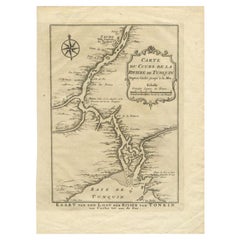
- Antique Map of the Tunquin River and Bay to Cacho, the Capital City, Siam, 1758Located in Langweer, NLAntique map titled ‘Kaart van den Loop der Rivier van Tonkin van Cacho tot aan de Zee / Carte du Cours de la Riviere de Tunquin Depuis Cacho jusqu'à la Mer J. v. Schley direx.’ Detailed map of the Tunquin River and Bay, extending north to Cacho, the capital...Category
Antique 18th Century Maps
MaterialsPaper
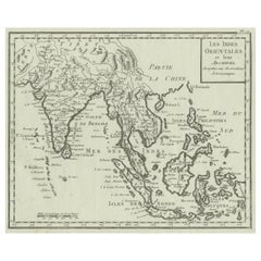
- Antique Map of India, the East Indies and the PhilippinesLocated in Langweer, NLAntique map titled 'Les Indes Orientales et leur Archipel'. Original antique map of India, the East Indies and the Philippines. Source unknown, to be determined. Published circa 1760.Category
Antique Mid-18th Century Maps
MaterialsPaper
- Antique Map of Luzon of Luconia in the Philippines, 1726Located in Langweer, NLDescription: Antique map titled 'Lucon of Luconia'. Luzon is the largest and most populous island in the Philippines. It is ranked 15th largest in the world by land area. Located i...Category
Antique 1720s Maps
MaterialsPaper

You May Also Like
- Map of the Republic of GenoaLocated in New York, NYFramed antique hand-coloured map of the Republic of Genoa including the duchies of Mantua, Modena, and Parma. Europe, late 18th century. Dimension: 25...Category
Antique Late 18th Century European Maps
- Antique Map of Principality of MonacoBy Antonio Vallardi EditoreLocated in Alessandria, PiemonteST/619 - "Old Geographical Atlas of Italy - Topographic map of ex-Principality of Monaco" - ediz Vallardi - Milano - A somewhat special edition ---Category
Antique Late 19th Century Italian Other Prints
MaterialsPaper
- Map "Estuary- Mouth of the Thames"Located in Alessandria, PiemonteST/426 - Antique French Map of the estuary of the Thames, map dated 1769 - "Mape of the entrance of the Thames. Designed by filing of Navy cards fo...Category
Antique Mid-18th Century French Other Prints
MaterialsPaper
- Antique 18th Century Map of the Province of Pensilvania 'Pennsylvania State'Located in Philadelphia, PAA fine antique of the colony of Pennsylvania. Noted at the top of the sheet as a 'Map of the province of Pensilvania'. This undated and anonymous map is thought to be from the Gentleman's Magazine, London, circa 1775, although the general appearance could date it to the 1760's. The southern boundary reflects the Mason-Dixon survey (1768), the western boundary is placed just west of Pittsburgh, and the northern boundary is not marked. The map has a number of reference points that likely refer to companion text and appear to be connected to boundaries. The western and southern boundaries are marked Q, R, S, for example. A diagonal line runs from the Susquehanna R to the Lake Erie P. A broken line marked by many letters A, B, N, O, etc., appears in the east. There are no latitude or longitude markings, blank verso. Framed in a shaped contemporary gilt wooden frame and matted under a cream colored matte. Bearing an old Graham Arader Gallery...Category
Antique 18th Century British American Colonial Maps
MaterialsPaper
- Large Antique 1859 Map of North AmericaLocated in Sag Harbor, NYThis Map was made by Augustus Mitchell in 1859 It is in amazing condition for being 163 years old. This price is for the rolled up easy to ship version of this piece. I will be Frami...Category
Antique Mid-19th Century American Maps
MaterialsCanvas, Paper

- Antique Map of Italy by Andriveau-Goujon, 1843By Andriveau-GoujonLocated in New York, NYAntique Map of Italy by Andriveau-Goujon, 1843. Map of Italy in two parts by Andriveau-Goujon for the Library of Prince Carini at Palazzo Carini i...Category
Antique 1840s French Maps
MaterialsLinen, Paper


Recently Viewed
View AllMore Ways To Browse
Filipino Furniture
Capital Of Antique
Antique Capital
Antique Voyage
Voyage Antique
Philippines Antique
Antique Philippines
Filipino Antique
Antique Filipino Furniture
Manila Antique
Antique Furniture Manila
Filipino Map
Philippines Map
Antique Map Of The Philippines
Map Of Antique Philippines
Antique Map Philippines
Philippines Antique Map
Antique Maps Philippines