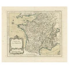
Items Similar to Antique Map of France with a Nice Cartouche of a Distance Scale, c.1756


Want more images or videos?
Request additional images or videos from the seller
1 of 5
Antique Map of France with a Nice Cartouche of a Distance Scale, c.1756
About the Item
Antique map titled 'France'. Engraved map of France with a small, decorative title cartouche and distance scale. Originates from 'A New Geographical and Historical Grammar (..)', by Thomas Salmon, published in London, c.1756.
Artists and Engravers: Thomas Jefferys (c.1719 - 1771), ""Geographer to King George III"", was an English cartographer who was the leading map supplier of his day. He engraved and printed maps for government and other official bodies and produced a wide range of commercial maps and atlases, especially of North America.
Condition: Very good. Folds as issued. Tape on top of verso. Please study image carefully.
Date: c.1756
Overall size: 24 x 19 cm.
Image size: 22.5 x 18 cm.
- Dimensions:Height: 7.49 in (19 cm)Width: 9.45 in (24 cm)Depth: 0 in (0.01 mm)
- Materials and Techniques:
- Period:
- Date of Manufacture:circa 1756
- Condition:
- Seller Location:Langweer, NL
- Reference Number:
About the Seller
5.0
Platinum Seller
These expertly vetted sellers are 1stDibs' most experienced sellers and are rated highest by our customers.
Established in 2009
1stDibs seller since 2017
1,948 sales on 1stDibs
Typical response time: <1 hour
- ShippingRetrieving quote...Ships From: Langweer, Netherlands
- Return PolicyA return for this item may be initiated within 14 days of delivery.
More From This SellerView All
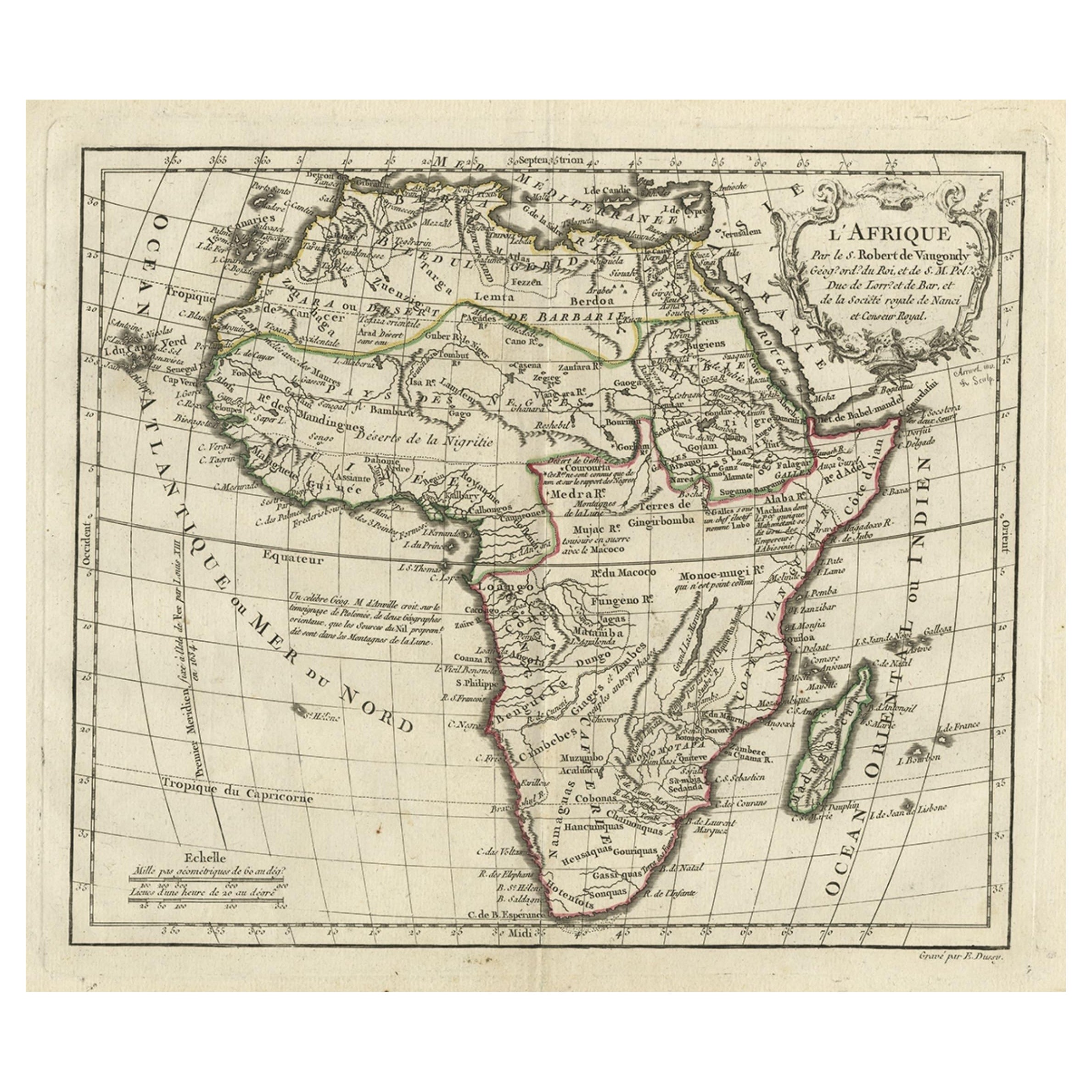
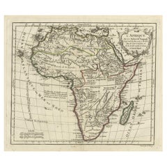
- Antique Map of Africa with French Cartouche and Scale, c.1780Located in Langweer, NLAntique map titled 'L'Afrique'. Original antique map of Africa. With beautiful title cartouche and scale. Source unknown, to be determined. Artists and Engravers: Gilles Robert de...Category
Antique 18th Century Maps
MaterialsPaper
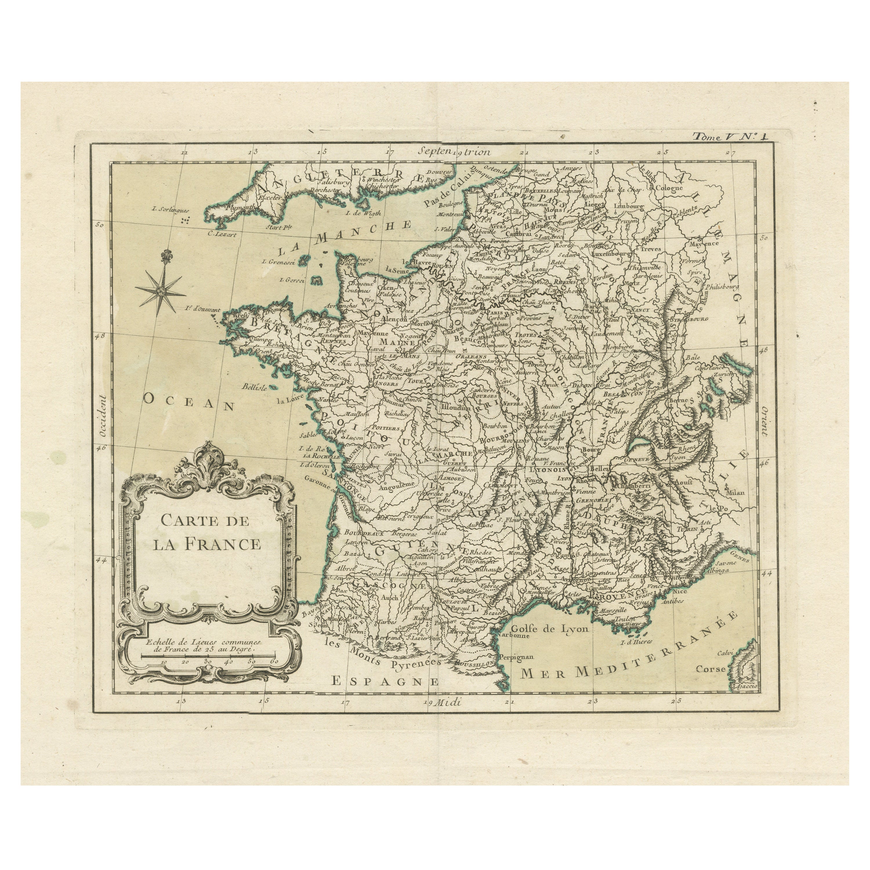
- Antique Map of France with Decorative Title CartoucheLocated in Langweer, NLAntique map titled 'Carte de la France'. Original old map of France. This map originates from 'Le Petit Atlas Maritime Recueil De Cartes et Plans Des Quatre Parties Du Monde (..) by ...Category
Antique Mid-18th Century Maps
MaterialsPaper
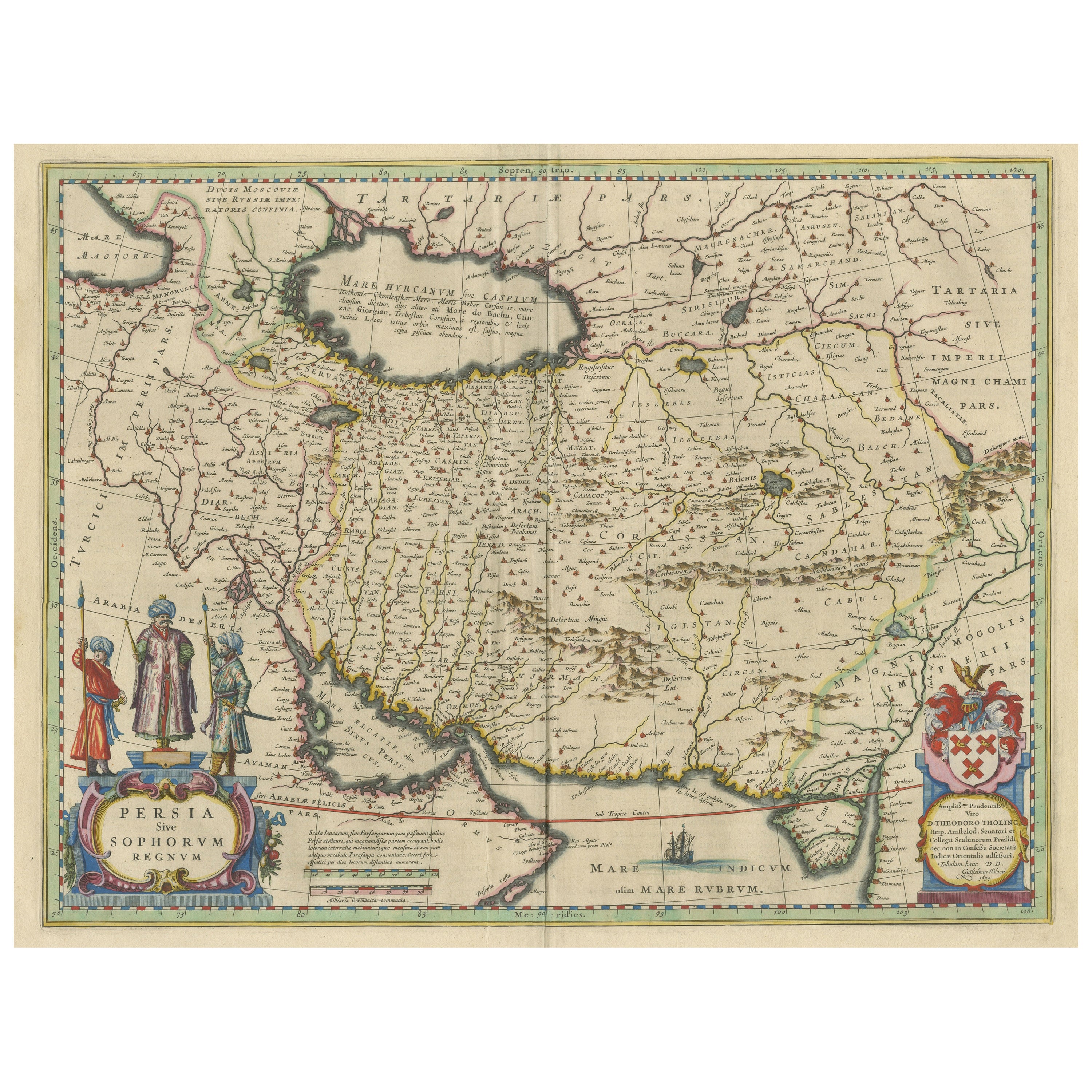
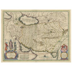
- Antique Map of Persia with Dedication CartoucheLocated in Langweer, NLAntique map titled 'Persia sive Sophorum Regnum'. Original old map of Persia. The map extends from the Eastern Mediteranian to Tacalistan and the Indus River and the Dalanguer Mounta...Category
Antique Mid-17th Century Maps
MaterialsPaper
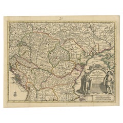
- Antique French Map of Hungary with Decorative Title Cartouche, c.1730Located in Langweer, NLAntique map titled 'La Hongrie suivant les Nouvelles Observations (..)'. Antique map of Hungary with decorative title cartouche. Artists and Engravers: ...Category
Antique 18th Century Maps
MaterialsPaper
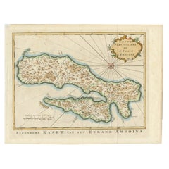
- Antique Map of Ambon Island, Indonesia, 1756Located in Langweer, NLAntique map titled ‘Carte particuliere de l'Isle d'Amboine - Byzondere kaart van het eyland Amboina’. Antique map of the island of Ambon, Indonesia. This map originates from 'Histori...Category
Antique 18th Century Maps
MaterialsPaper
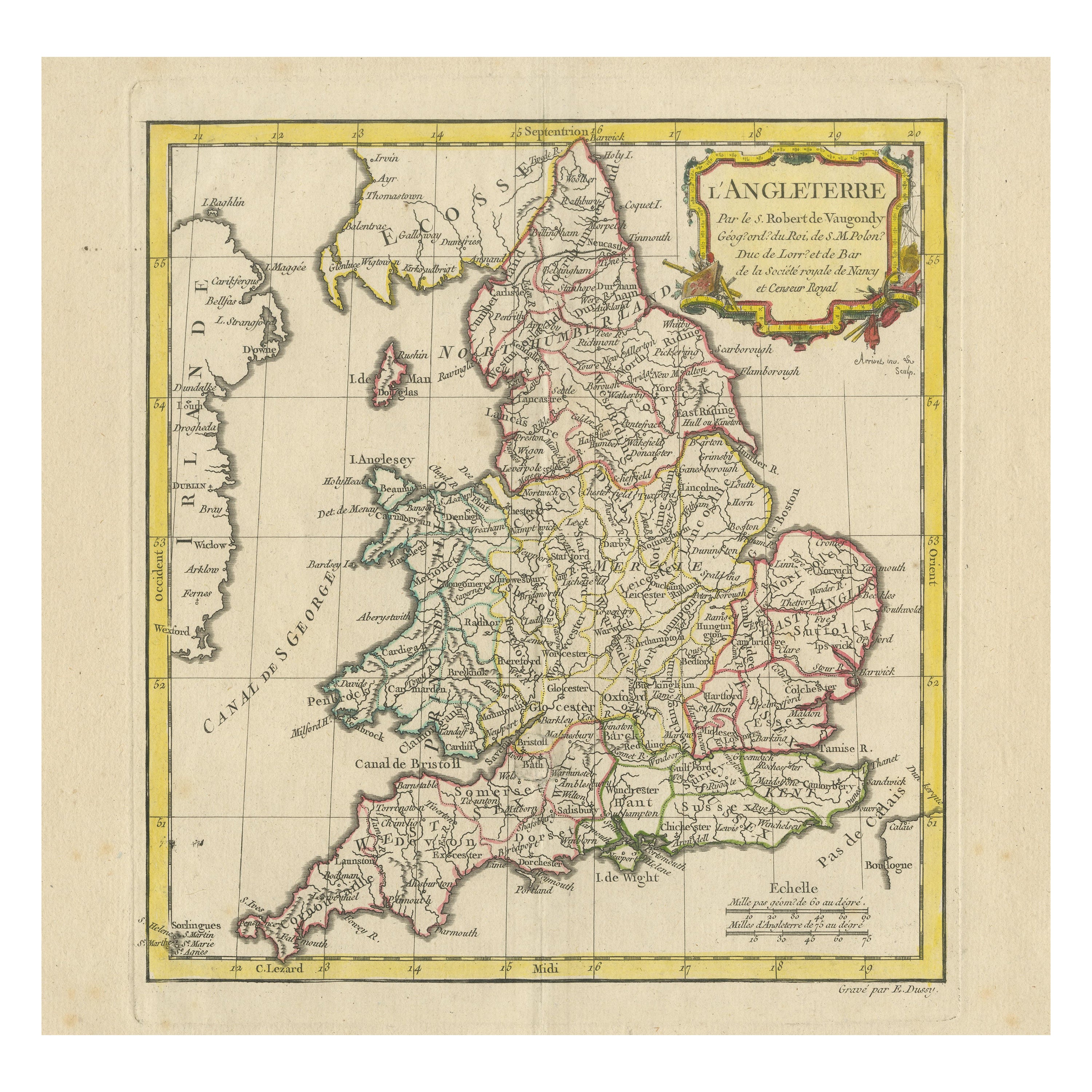
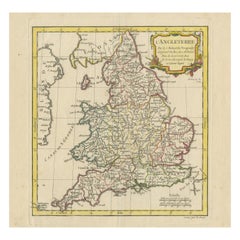
- Original Antique Map of England with Decorative CartoucheLocated in Langweer, NLAntique map titled 'l'Angleterre (..)'. Original antique map of England, with beautiful hand coloring and decorative cartouche. This map originates from 'Nouvel Atlas Portatif destin...Category
Antique Late 18th Century Maps
MaterialsPaper
You May Also Like
- Large Scale Antique Scroll Map of Lincolnshire, England, Dated 1778Located in St Annes, LancashireWonderful scroll map of Lincolnshire By Captain Armstrong, 1778 Copper plate engraving on paper laid on canvas Original ebonized wood frame with lo...Category
Antique 1770s English Georgian Maps
MaterialsWood, Paper
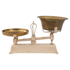
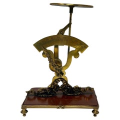
- Antique French Cast Iron ScaleLocated in High Point, NCThis cast iron scale was made in France, circa 1900. A ubiquitous classic in the home or the market, scales of these dimensions were commonly used to weig...Category
Antique Early 1900s French French Provincial Scientific Instruments
MaterialsBrass, Iron
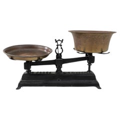
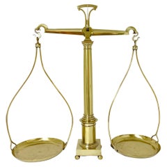
- Large Antique French Neoclassical Brass ScaleLocated in West Palm Beach, FLLarge Antique French Neoclassical Brass Scale, by Berenger & Co, Lyon France, Circa 1870 A stunning Large Antique French Neoclassical Brass Scale, crafted by the renowned Berenger & Co of Lyon during the mid to late 19th Century. This remarkable brass shop keepers, assay or pharmacist scale...Category
Antique Late 19th Century French Neoclassical Scientific Instruments
MaterialsBrass
- Antique Map of Principality of MonacoBy Antonio Vallardi EditoreLocated in Alessandria, PiemonteST/619 - "Old Geographical Atlas of Italy - Topographic map of ex-Principality of Monaco" - ediz Vallardi - Milano - A somewhat special edition ---Category
Antique Late 19th Century Italian Other Prints
MaterialsPaper
- Antique French Grocers Scale Circa 1890Located in New Orleans, LAAntique French Grocers Scale Circa 1890Category
Antique Late 19th Century French Scientific Instruments
MaterialsBrass


Recently Viewed
View AllMore Ways To Browse
Antique Cartouches
Antique Scales Collectables
Antique Scales Collectibles
Antique Scales Collectable Scales
French 19c
Scale Map
18th C American
English Antique Scale
George Map
18c French Furniture
Map North America
Map Of North America
18th C American Furniture
George C Thomas
King George Iii
French Map Of America
King Size Antique French
Antique French 18th Century Map