Items Similar to Antique Map of Germany from an American 19th Century Atlas, 1846


Want more images or videos?
Request additional images or videos from the seller
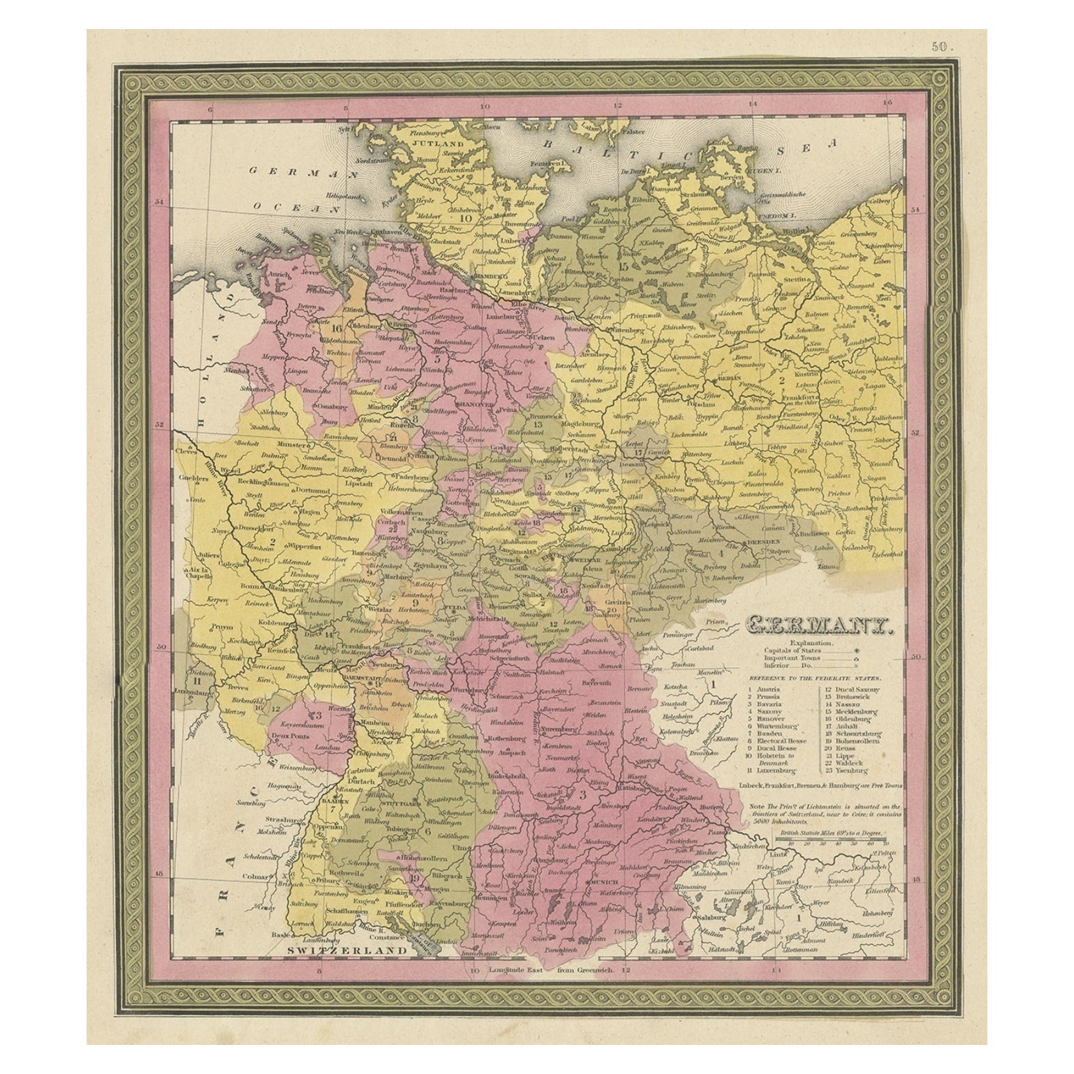
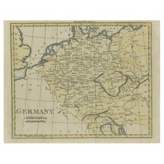
Antique Map of Germany from an American 19th Century Atlas, 1846
About the Item
Antique map titled 'Germany'. Old map of Germany. This map originates from 'A New Universal Atlas Containing Maps of the various Empires, Kingdoms, States and Republics Of The World (..) by S.A. Mitchell. Artists and Engravers: Samuel Augustus Mitchell was an American geographer. Mitchell worked as a teacher before turning to publishing geography textbooks and maps. He became involved in geography after teaching and realizing that there were so many poor quality geographical resources available to teachers. He was in Philadelphia when he founded his company. His son, S. Augustus Mitchell, became owner in 1860. Their publications covered all genres of geography: maps, travel guides, textbooks, and more.
Artist: Samuel Augustus Mitchell was an American geographer. Mitchell worked as a teacher before turning to publishing geography textbooks and maps. He became involved in geography after teaching and realizing that there were so many poor quality geographical resources available to teachers. He was in Philadelphia when he founded his company. His son, S. Augustus Mitchell, became owner in 1860. Their publications covered all genres of geography: maps, travel guides, textbooks, and more.
Condition: Good, original/contemporary hand coloring. Age-related toning and some wear, mainly in margins. Blank verso, please study image carefully.
Date: 1846
Overall size: 0.001 x 35 x 43.5 cm.
Image size: 26 x 29 cm.
We sell original antique maps to collectors, historians, educators and interior decorators all over the world. Our collection includes a wide range of authentic antique maps from the 16th to the 20th centuries. Buying and collecting antique maps is a tradition that goes back hundreds of years. Antique maps have proved a richly rewarding investment over the past decade, thanks to a growing appreciation of their unique historical appeal. Today the decorative qualities of antique maps are widely recognized by interior designers who appreciate their beauty and design flexibility. Depending on the individual map, presentation, and context, a rare or antique map can be modern, traditional, abstract, figurative, serious or whimsical. We offer a wide range of authentic antique maps for any budget.
- Dimensions:Height: 17.13 in (43.5 cm)Width: 13.78 in (35 cm)Depth: 0 in (0.01 mm)
- Materials and Techniques:
- Period:
- Date of Manufacture:1846
- Condition:
- Seller Location:Langweer, NL
- Reference Number:
About the Seller
5.0
Platinum Seller
These expertly vetted sellers are 1stDibs' most experienced sellers and are rated highest by our customers.
Established in 2009
1stDibs seller since 2017
1,956 sales on 1stDibs
Typical response time: <1 hour
- ShippingRetrieving quote...Ships From: Langweer, Netherlands
- Return PolicyA return for this item may be initiated within 14 days of delivery.
More From This SellerView All
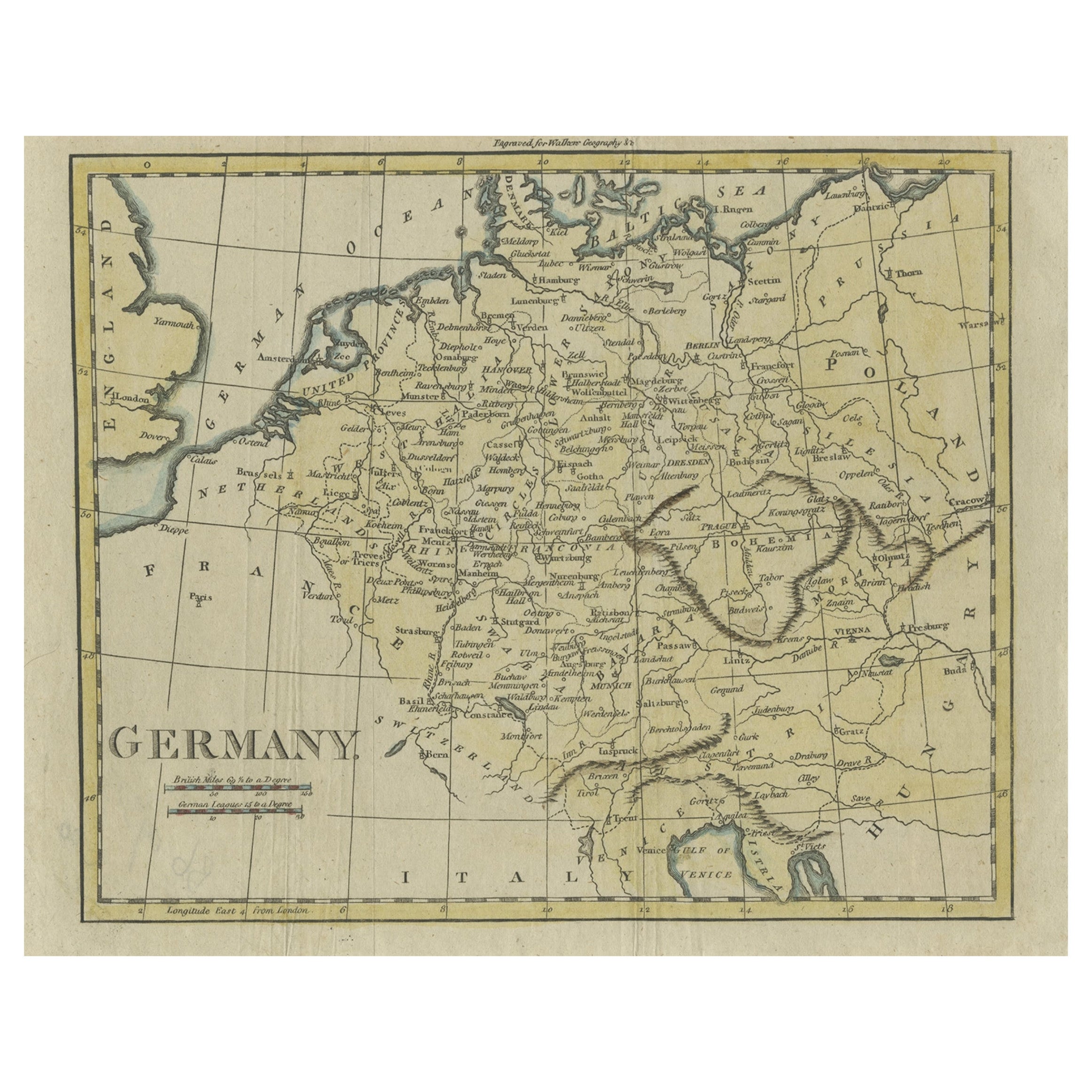
- Antique Map of Germany from an Old English Atlas, c.1802Located in Langweer, NLAntique map titled 'Germany'. Antique map of Germany engraved for 'Atlas to Walker's Geography'. Artists and Engravers: Engraved by W. Darton. Artist: Engraved by W. Darton. Co...Category
Antique 19th Century Maps
MaterialsPaper
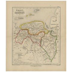
- Antique Map of Groningen from a 19th Century Dutch Atlas, 1864Located in Langweer, NLAntique map titled 'De Provincie Groningen'. Map of the province of Groningen, the Netherlands. This map originates from 'F. C. Brugsma's Atlas van het Koninkrijk der Nederlanden (.....Category
Antique 19th Century Maps
MaterialsPaper
- Decorative Antique Map of Germany, 1846Located in Langweer, NLAntique map titled 'Germany'. Old map of Germany. This map originates from 'A New Universal Atlas Containing Maps of the various Empires, Kingdoms, ...Category
Antique 1840s Maps
MaterialsPaper
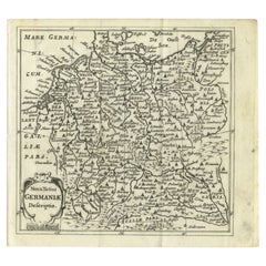
- Antique Map of Germany from a 17th Century Pocket Atlas, 1685Located in Langweer, NLAntique map titled 'Nova Totius Germaniae descriptio.' Miniature map of Germany, from the pocket atlas 'Introductionis in Universam Geographiam tam Veterem...Category
Antique 17th Century Maps
MaterialsPaper
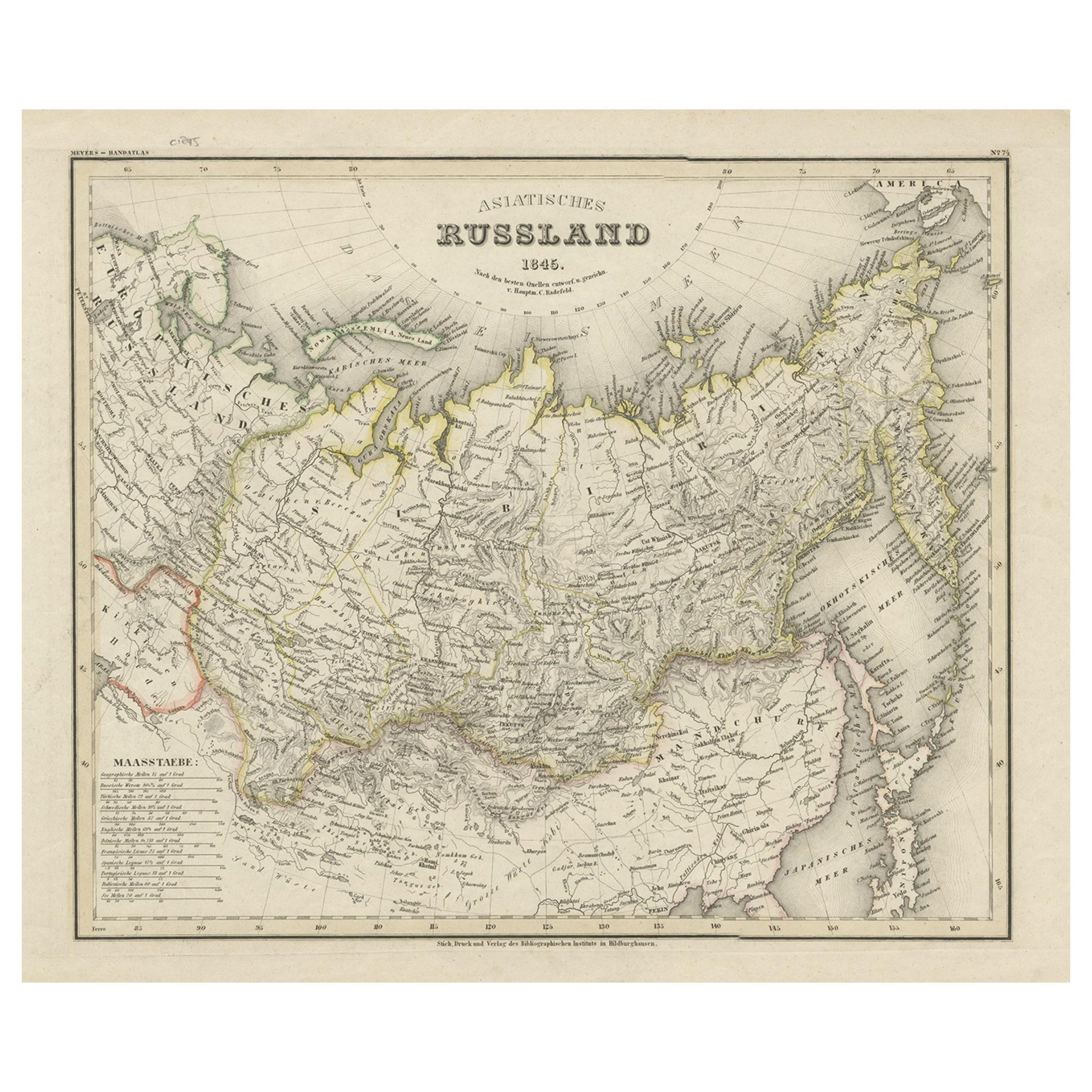
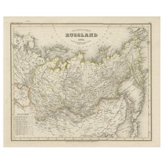
- Antique Map of Russia in Asia from An Old German Atlas, 1845By MeyerLocated in Langweer, NLAntique map titled 'Asiatisches Russland'. This map depicts Russia in Asia and originates from 'Meyers Handatlas'. Artists and Engravers: Engraved and published by 'Bibliographis...Category
Antique 19th Century Maps
MaterialsPaper
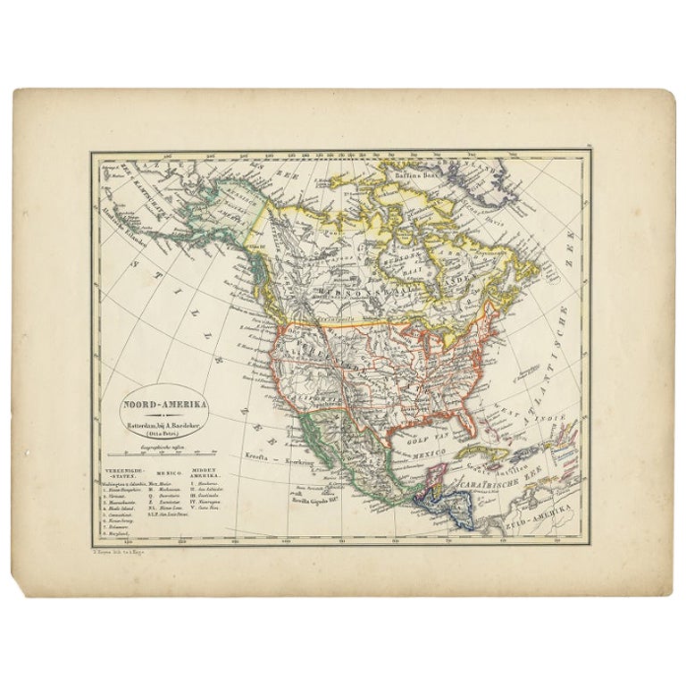
- Antique Map of North America from an Old Dutch School Atlas, 1852Located in Langweer, NLAntique map titled 'Noord-Amerika'. Map of North America. This map originates from 'School-Atlas van alle deelen der Aarde' by Otto Petri. Artists and Engra...Category
Antique 19th Century Maps
MaterialsPaper


You May Also Like
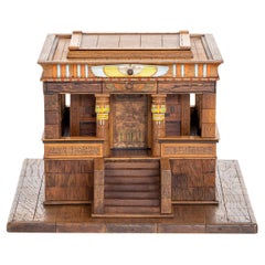
- 19th Century German Antique Mahogany, Walnut Model of an Egyptian TempleLocated in West Palm Beach, FLA light-brown, antique German model of an Egyptian temple made of handcrafted, partly painted Mahogany and Walnut, in good condition. The inside of the de...Category
Antique Early 19th Century German Architectural Models
MaterialsMahogany, Walnut
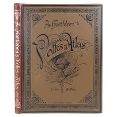
- Antique German Hartleben's Volks Atlas Book World MapsLocated in Seguin, TXAntique circa 1900 A. Hartleben's Volks-Atlas. Published by A. Hartleben's, Germany. Folio hardcover with decorated olive cloth binding and brown leather spine. Gilt title to spine...Category
Early 20th Century German Aesthetic Movement Maps
MaterialsPaper
- America "Amérique Septentrionale": A 19th Century French Map by DelamarcheBy Maison Delamarche 1Located in Alamo, CAThis framed mid 19th century map of North America entitled "Amérique Septentrionale" by Felix Delamarche was published in Paris in 1854 by Quay de l'Horloge du Palais, avec les Carte...Category
Antique Mid-19th Century American Other Maps
MaterialsPaper
- Antique Framed Pen and Ink on Fabric Map of Cornwall from Early 19th CenturyLocated in Los Angeles, CAEarly 19th-century English pen-and-ink fabric map of Cornwall. With beautiful hand-drawn details and faded sepia tones, this framed piece turns history into art. England, circa 181...Category
Antique Early 19th Century English Drawings
MaterialsFabric, Walnut
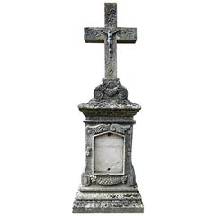
- Antique Tombstone from France, 19th CenturyLocated in Udenhout, NLBeautiful recuperated antique tombstone from France. Recuperated from a cemetery near Paris.Category
Antique 1840s French Religious Items
MaterialsSandstone
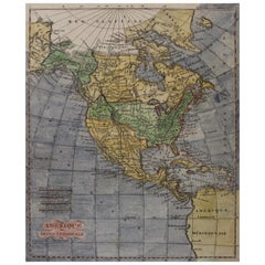
- Early 19th Century Hand Coloured Map of North America by Aaron ArrowsmithBy Aaron ArrowsmithLocated in Hamilton, OntarioHand coloured map in French by English cartographer Aaron Arrowsmith (1750–1823) titled "Amerique Septentionale" (North America). Map size: 9.5" x 8" Mat size: 20.5" x 14.25".Category
Antique Early 19th Century English Maps
MaterialsPaper


Recently Viewed
View AllMore Ways To Browse
Antique Furniture From Germany
19th Century German Collectibles
American Empire Antiques
Old American Maps
Philadelphia Map
Atlas Furniture Company
Historical Maps Germany
Antique Resources
Antique Travel Map
Antique Map German Empire
Antique Maps Philadelphia
Antique Map Of Philadelphia
Antique Maps Of Philadelphia
Antique Map Philadelphia
Mitchell Antique Maps
United States Map Antique
Antique United States Map
Railroad Antique