Items Similar to Antique Map of Germany from a 17th Century Pocket Atlas, 1685


Want more images or videos?
Request additional images or videos from the seller
1 of 5
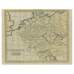
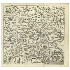
Antique Map of Germany from a 17th Century Pocket Atlas, 1685
About the Item
Antique map titled 'Nova Totius Germaniae descriptio.' Miniature map of Germany, from the pocket atlas 'Introductionis in Universam Geographiam tam Veterem quam novam .. Acessit P. Bertii (Bertius) Brevarium Orbis Terrarum', by Ph. Cluverius (Cluver). Artists and Engravers: Philipp Cluver (1580 - 1622), early modern German geographer and historian.
Artist: Philipp Cluver (1580 - 1622), early modern German geographer and historian.
Condition: Good, given age. Original folds as issued. General age-related toning and/or occasional minor defects from handling. Please study image carefully.
Date: 1685
Overall size: 14 x 13 cm.
Image size: 12.3 x 11.8 cm.
We sell original antique maps to collectors, historians, educators and interior decorators all over the world. Our collection includes a wide range of authentic antique maps from the 16th to the 20th centuries. Buying and collecting antique maps is a tradition that goes back hundreds of years. Antique maps have proved a richly rewarding investment over the past decade, thanks to a growing appreciation of their unique historical appeal. Today the decorative qualities of antique maps are widely recognized by interior designers who appreciate their beauty and design flexibility. Depending on the individual map, presentation, and context, a rare or antique map can be modern, traditional, abstract, figurative, serious or whimsical. We offer a wide range of authentic antique maps for any budget.
- Dimensions:Height: 5.12 in (13 cm)Width: 5.52 in (14 cm)Depth: 0 in (0.01 mm)
- Materials and Techniques:
- Period:
- Date of Manufacture:1685
- Condition:
- Seller Location:Langweer, NL
- Reference Number:
About the Seller
5.0
Platinum Seller
These expertly vetted sellers are 1stDibs' most experienced sellers and are rated highest by our customers.
Established in 2009
1stDibs seller since 2017
1,929 sales on 1stDibs
Typical response time: <1 hour
- ShippingRetrieving quote...Ships From: Langweer, Netherlands
- Return PolicyA return for this item may be initiated within 14 days of delivery.
More From This SellerView All
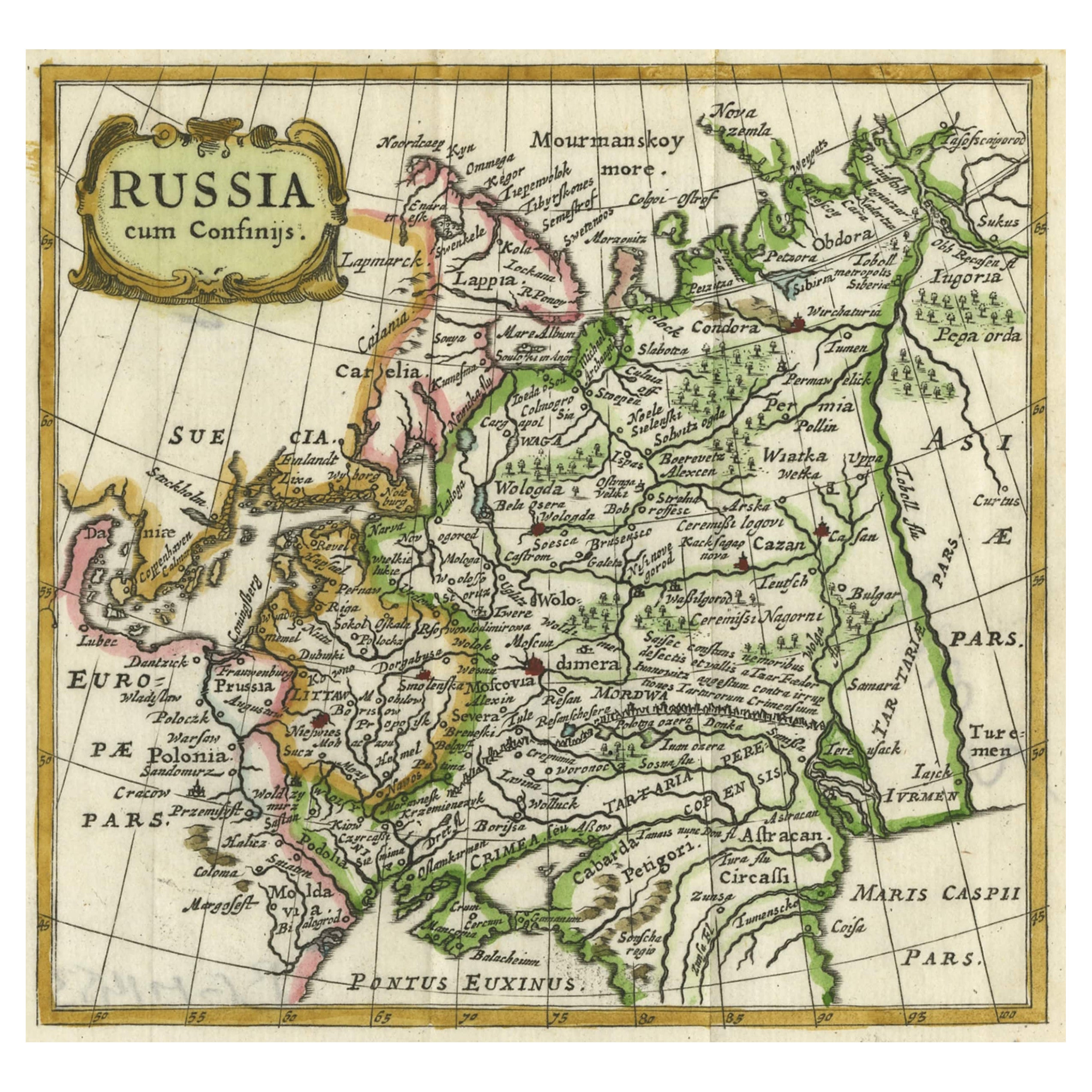
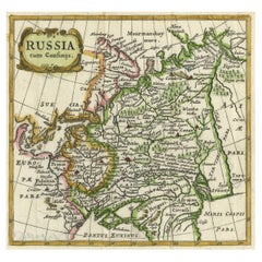
- Charming Decorative Miniature Map of Russia, from an Old Pocket Atlas, 1685Located in Langweer, NLAntique map titled 'Russia cum Consinijs'.' Charming miniature map of Russia, from the pocket atlas 'Introductionis in Universam Geographiam tam Veterem quam novam .. Acessit P. ...Category
Antique 1680s Maps
MaterialsPaper
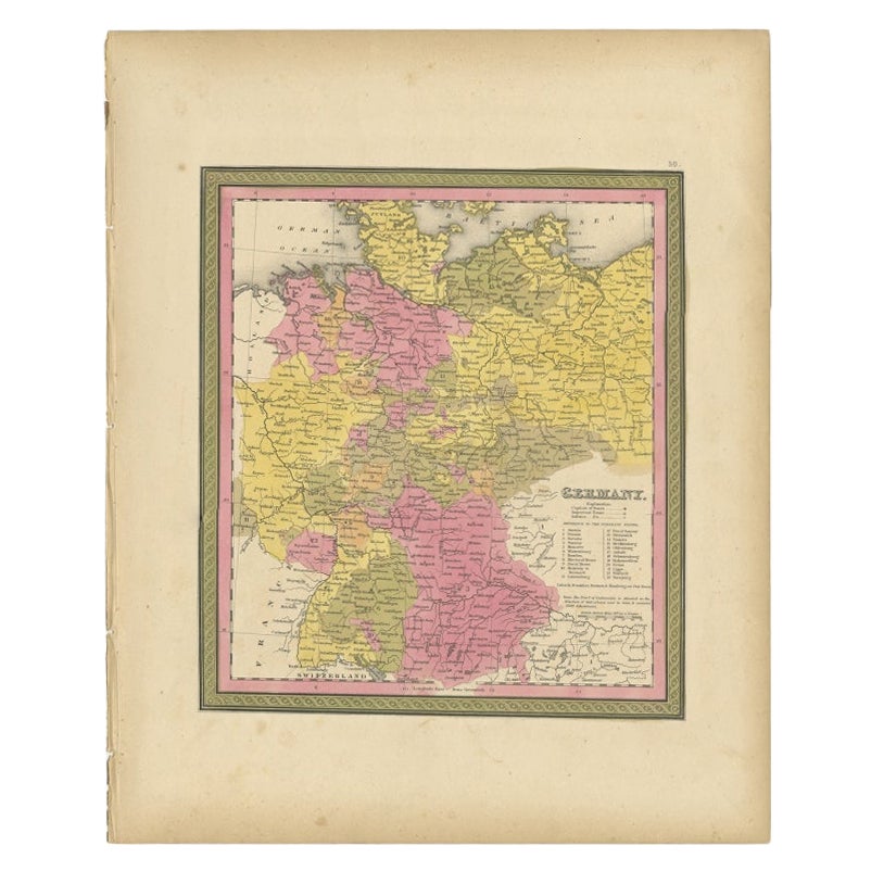
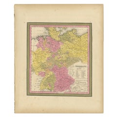
- Antique Map of Germany from an American 19th Century Atlas, 1846Located in Langweer, NLAntique map titled 'Germany'. Old map of Germany. This map originates from 'A New Universal Atlas Containing Maps of the various Empires, Kingdoms, States and Republics Of The World ...Category
Antique 19th Century Maps
MaterialsPaper
- Antique Map of Asia from a German School Atlas, c.1870Located in Langweer, NLAntique map titled 'Asien'. Old map of the Asian continent. This map originates from 'H. Kiepert's Kleiner Atlas der Neueren Geographie für Schule und Haus'. Artists and Engravers:...Category
Antique 19th Century Maps
MaterialsPaper
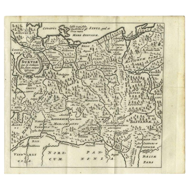
- Antique Map of Swabia, 1685Located in Langweer, NLAntique map titled 'Sueviae quae cis Codanum fuit finum Antiqua defcriptio.' Miniature map of Swabia, a medieval Duchy in south-west Germany, that also included part of Poland, from ...Category
Antique 17th Century Maps
MaterialsPaper
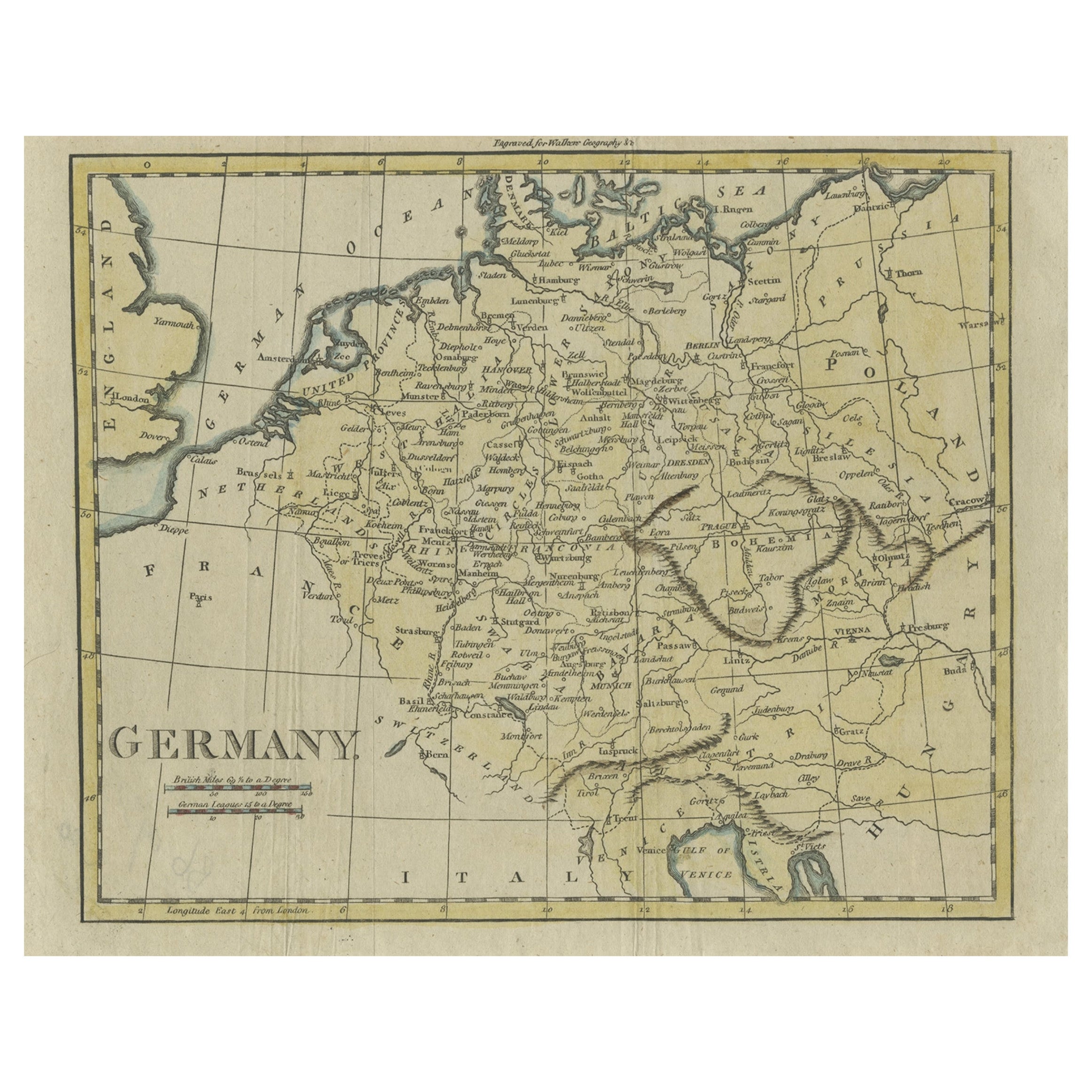
- Antique Map of Germany from an Old English Atlas, c.1802Located in Langweer, NLAntique map titled 'Germany'. Antique map of Germany engraved for 'Atlas to Walker's Geography'. Artists and Engravers: Engraved by W. Darton. Artist: Engraved by W. Darton. Co...Category
Antique 19th Century Maps
MaterialsPaper
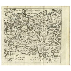
- Antique Map of Southern Germany and Switzerland by Cluver, 1685Located in Langweer, NL"Antique map titled 'Vindeliciae et Norici conterminarunque terrarum antiqua descriptio.' Miniature map of south Germany and Switzerland in Celtic times, From the pocket atlas 'Intro...Category
Antique 17th Century Maps
MaterialsPaper

You May Also Like
- 17th Century Hand-Colored Map of a Region in West Germany by JanssoniusBy Johannes JanssoniusLocated in Alamo, CAThis attractive highly detailed 17th century original hand-colored map is entitled "Archiepiscopatus Maghdeburgensis et Anhaltinus Ducatus cum terris adjacentibus". It was published ...Category
Antique Mid-17th Century Dutch Maps
MaterialsPaper
- 17th Century Nicolas Visscher Map of Southeastern EuropeLocated in Hamilton, OntarioA beautiful, highly detailed map of southeastern Europe by Nicolas Visscher. Includes regions of Northern Italy (showing the cities Bologna, Padua, and Venice), Bohemia, Austria (sho...Category
Antique 17th Century Dutch Maps
MaterialsPaper
- 17th Century John Speed Map of Denbighshire, c.1610By John SpeedLocated in Royal Tunbridge Wells, KentAntique early 17th century British very rare and original John Speed, hand coloured map of Denbighshire, dated 1610, by John Sunbury and George Humble. John...Category
Antique 17th Century British Maps
MaterialsWood, Paper
- Prussia, Poland, N. Germany, Etc: A Hand-colored 17th Century Map by JanssoniusBy Johannes JanssoniusLocated in Alamo, CAThis is an attractive hand-colored copperplate engraved 17th century map of Prussia entitled "Prussia Accurate Descripta a Gasparo Henneberg Erlichensi", published in Amsterdam by Joannes Janssonius in 1664. This very detailed map from the golden age of Dutch cartography includes present-day Poland, Latvia, Lithuania, Estonia and portions of Germany. This highly detailed map is embellished by three ornate pink, red, mint green and gold...Category
Antique Mid-17th Century Dutch Maps
MaterialsPaper
- 17th Century John Speed Map of the Barkshire Described, c.1616By John SpeedLocated in Royal Tunbridge Wells, KentAntique 17th century British very rare and original John Speed (1551-1629) map of the Barkshire Described, J. Sud and Georg Humble, publication (1616 or lat...Category
Antique 17th Century British Maps
MaterialsPaper
- Vintage Reproduction 17th Century Map of Europe, American, Cartography, BlaeuwLocated in Hele, Devon, GBThis is a vintage reproduction map of Europe. An American, paper stock cartography print in frame after the work by Blaeuw, dating to the late 20t...Category
Late 20th Century Central American Mid-Century Modern Maps
MaterialsGlass, Wood, Paper


Recently Viewed
View AllMore Ways To Browse
Antique Furniture From Germany
German 17th Century Furniture
17th Century German Furniture
Orbis Map
17th Century World Map
Antique 17th Century World Map
Historical Maps Germany
Miniature Maps
Miniature Map
Pocket Map
Nova Totius
United States Map Antique
Antique United States Map
Railroad Antique
Antique Maps Of United States
Antique Collectible Bears
United States Map Vintage
United States Vintage Map