Items Similar to Antique Map of Southern Germany and Switzerland by Cluver, 1685
Want more images or videos?
Request additional images or videos from the seller
Antique Map of Southern Germany and Switzerland by Cluver, 1685
About the Item
"Antique map titled 'Vindeliciae et Norici conterminarunque terrarum antiqua descriptio.' Miniature map of south Germany and Switzerland in Celtic times, From the pocket atlas 'Introductionis in Universam Geographiam tam Veterem quam novam .. Acessit P. Bertii (Bertius) Brevarium Orbis Terrarum', by Ph. Cluverius (Cluver). Artists and Engravers: Philipp Cluver (1580 - 1622), early modern German geographer and historian.
Artist: Philipp Cluver (1580 - 1622), early modern German geographer and historian.
Condition: Good, given age. Original folds as issued. General age-related toning and/or occasional minor defects from handling. Please study image carefully.
Date: 1685
Overall size: 13.8 x 13 cm.
Image size: 0.001 x 12.3 x 11.8 cm.
Antique prints have long been appreciated for both their aesthetic and investment value. They were the product of engraved, etched or lithographed plates. These plates were handmade out of wood or metal, which required an incredible level of skill, patience and craftsmanship. Whether you have a house with Victorian furniture or more contemporary decor an old engraving can enhance your living space.
- Dimensions:Height: 5.12 in (13 cm)Width: 5.44 in (13.8 cm)Depth: 0 in (0.01 mm)
- Materials and Techniques:
- Period:
- Date of Manufacture:1685
- Condition:
- Seller Location:Langweer, NL
- Reference Number:
About the Seller
5.0
Platinum Seller
These expertly vetted sellers are 1stDibs' most experienced sellers and are rated highest by our customers.
Established in 2009
1stDibs seller since 2017
1,950 sales on 1stDibs
Typical response time: <1 hour
- ShippingRetrieving quote...Ships From: Langweer, Netherlands
- Return PolicyA return for this item may be initiated within 14 days of delivery.
More From This SellerView All
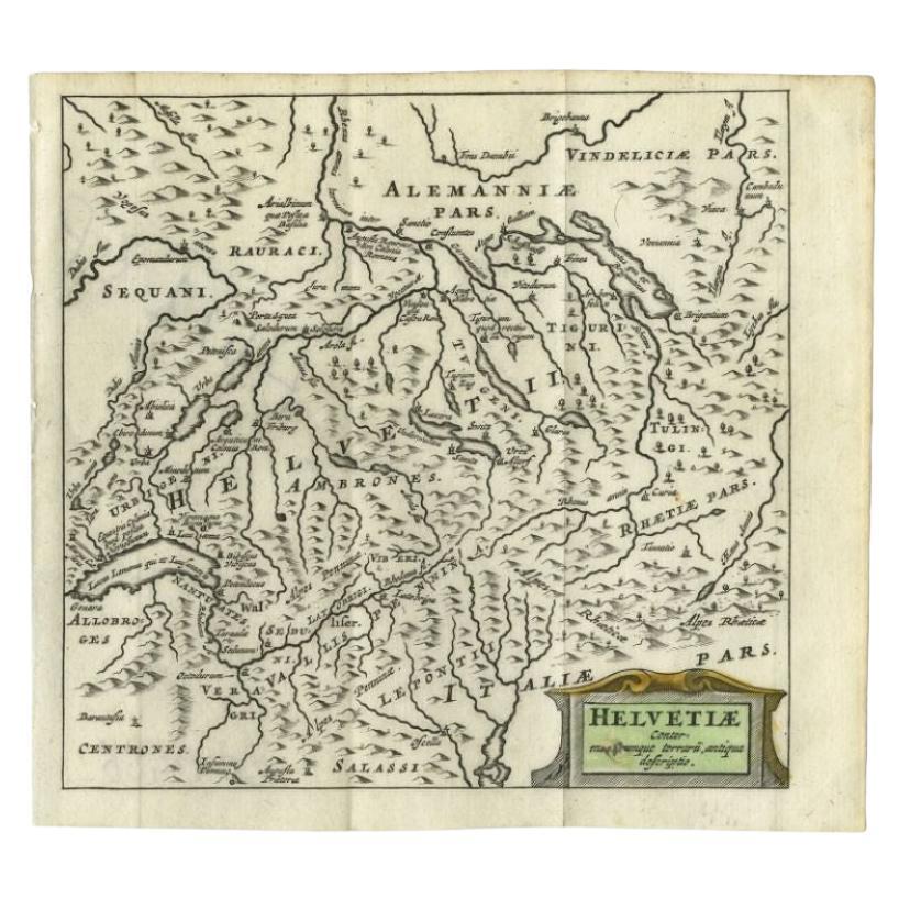
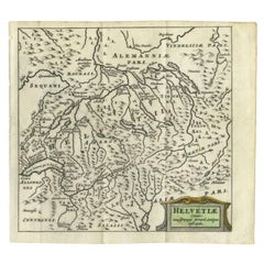
- Antique Map of Switzerland by Cluver, 1685Located in Langweer, NLAntique map titled 'Helvetiae Conterminarumque Terrarii, antiqua descriptio.' Miniature map of Switzerland, from the pocket atlas 'Introductionis in...Category
Antique 17th Century Maps
MaterialsPaper
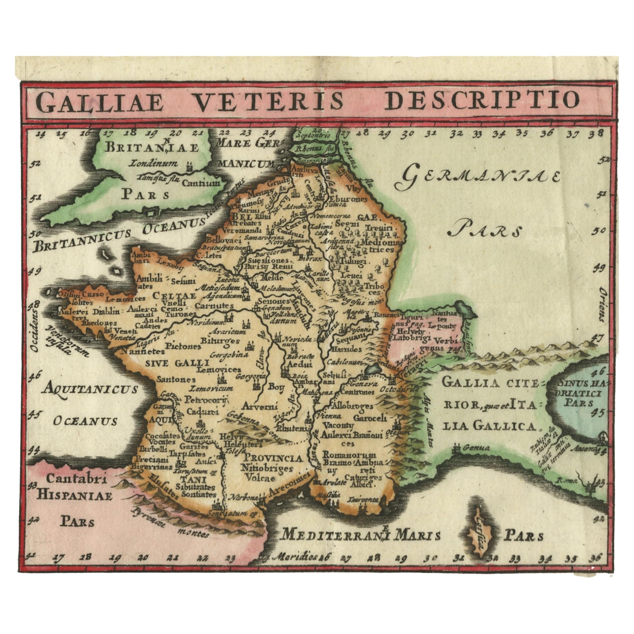
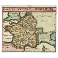
- Antique Map of France by Cluver, 1685Located in Langweer, NLAntique map titled 'Galliae Veteris Descriptio.' Charming miniature map of France from the pocket atlas 'Introductionis in Universam Geographiam tam Veterem quam novam .. Acessit P. ...Category
Antique 17th Century Maps
MaterialsPaper
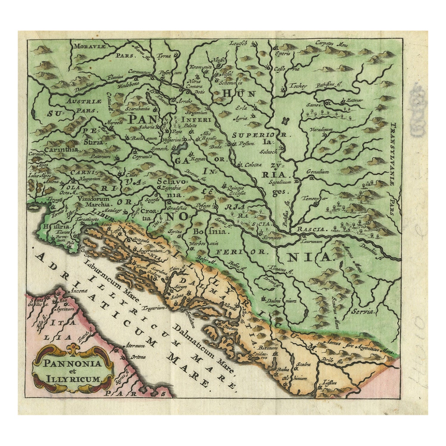
- Antique Map of Pannonia and Illyria by Cluver, 1685Located in Langweer, NLAntique map titled 'Pannonia et Illyricum.' Charming miniature map of Pannonia and Illyria, from the pocket atlas 'Introductionis in Universam Geographiam tam Veterem quam novam .. A...Category
Antique 17th Century Maps
MaterialsPaper
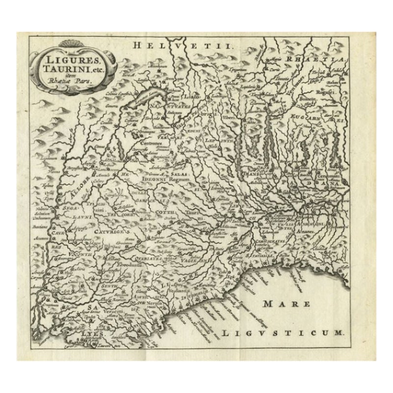
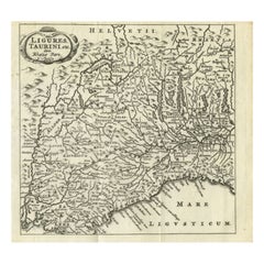
- Antique Map of Northwest Italy by Cluver, 1685Located in Langweer, NLAntique map titled 'Ligures, Taurini, etc.' Miniature map of northwest Italy. From the pocket atlas 'Introductionis in Universam Geographiam tam Veterem quam novam .. Acessit P. Bert...Category
Antique 17th Century Maps
MaterialsPaper
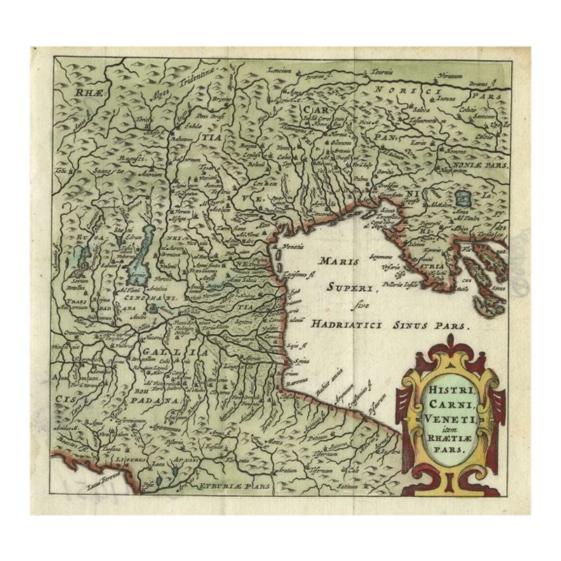
- Antique Map of Northern Italy by Cluver, 1685Located in Langweer, NLAntique map titled 'Histri, Carni, Veneti item Rhaetiae Pars.' Charming miniature map of northern Italy with the Adriatic or upper sea, now called the Gulf of Venice, from the pocket...Category
Antique 17th Century Maps
MaterialsPaper
- Antique Map of the Region Between the Rhine and Elbe River by Cluver, 1685Located in Langweer, NLAntique map titled 'Populorum Germanium inter Rhenum et Albim descriptio, ut inter Caesaris aevum incolurant (…).' Miniature map of the area between the Rhine and the Elbe, Germany. ...Category
Antique 17th Century Maps
MaterialsPaper


You May Also Like
- Original Antique Map of Switzerland, Engraved By Barlow, Dated 1807Located in St Annes, LancashireGreat map of Switzerland Copper-plate engraving by Barlow Published by Brightly & Kinnersly, Bungay, Suffolk. Dated 1807 Unframed.Category
Antique Early 1800s English Maps
MaterialsPaper
- East German MapBy VEB Hermann HaackLocated in Baltimore, MDA brilliantly colourful map of the Leipzig, Karl Marx Stadt and Dresden area in the former German Democratic Republic by VEB Hermann Haack of Gotha.Category
Vintage 1970s German Maps
- Southern Greece: A Large 17th C. Hand-colored Map by Sanson and JaillotBy Nicolas SansonLocated in Alamo, CAThis large original hand-colored copperplate engraved map of southern Greece and the Pelopponese Peninsula entitled "La Moree Et Les Isles De Zante, Cefalonie, Ste. Marie, Cerigo & C...Category
Antique 1690s French Maps
MaterialsPaper
- 18th Century Map of the Southern Balkans by Giovanni Maria CassiniBy Giovanni Maria CassiniLocated in Hamilton, Ontario18th century map by Italian engraver Giovanni Maria Cassini (Italy 1745-1824). Map of the Southern Balkans: Rome. Hand colored and copper engraved print done in the year 1788. It in...Category
Antique 18th Century Italian Maps
MaterialsPaper
- Set of 4 Antique Geographical Maps French-German War 1870-71Located in Casale Monferrato, ITElegant late 19th century set of four antique geographical maps relating to the positioning of the armies in the Franco-German War 1870-71. A...Category
Antique 1890s Italian Maps
MaterialsPaper
- Large Original Vintage Map of Switzerland, circa 1920Located in St Annes, LancashireGreat map of Switzerland Original color. Good condition Published by Alexander Gross Unframed.Category
Vintage 1920s English Maps
MaterialsPaper


Recently Viewed
View AllMore Ways To Browse
Swiss Antiques
Antique Decor And More
Swiss Old Furniture
Antique And Modern Decor
Swiss Metal Antique
Antique Swiss Wood
Southern Germany
Celtic Furniture
Antique Miniature Plates
Antique German Decor
Swiss Antiques And Collectables
17th Century German Engravings
Celtic Antiques
Miniature Maps
Miniature Map
Antique Map Switzerland
Pocket Map
Antique Map Of Switzerland