Items Similar to Antique Map of the Main Roads of Palembang by Stemler, c.1875

Want more images or videos?
Request additional images or videos from the seller
1 of 5
Antique Map of the Main Roads of Palembang by Stemler, c.1875
About the Item
Antique map titled 'Kaart van de voornaamste wegen in het zuidelijke deel der Residentie Palembang.' This scarce map shows the main roads in Palembang on the Indonesian island of Sumatra. Originates from 'Tijdschrift Aardrijkskundig Genootschap', published by C. F. Stemler in Amsterdam, ca. 1875.
Artists and Engravers: Map by C.L. Brinkman, Amsterdam and J.L. Beijers, Utrecht.
Condition: Fair/good, general age-related toning. Shows some wear and staining. Please study image carefully.
Date: c.1875
Overall size: 37 x 42.5 cm.
Image size: 34 x 39 cm
We sell original antique maps to collectors, historians, educators and interior decorators all over the world. Our collection includes a wide range of authentic antique maps from the 16th to the 20th centuries. Buying and collecting antique maps is a tradition that goes back hundreds of years. Antique maps have proved a richly rewarding investment over the past decade, thanks to a growing appreciation of their unique historical appeal. Today the decorative qualities of antique maps are widely recognized by interior designers who appreciate their beauty and design flexibility. Depending on the individual map, presentation, and context, a rare or antique map can be modern, traditional, abstract, figurative, serious or whimsical. We offer a wide range of authentic antique maps for any budget
- Dimensions:Height: 16.74 in (42.5 cm)Width: 14.57 in (37 cm)Depth: 0 in (0.01 mm)
- Materials and Techniques:
- Period:
- Date of Manufacture:circa 1875
- Condition:
- Seller Location:Langweer, NL
- Reference Number:
About the Seller
5.0
Platinum Seller
These expertly vetted sellers are 1stDibs' most experienced sellers and are rated highest by our customers.
Established in 2009
1stDibs seller since 2017
1,960 sales on 1stDibs
Typical response time: <1 hour
- ShippingRetrieving quote...Ships From: Langweer, Netherlands
- Return PolicyA return for this item may be initiated within 14 days of delivery.
More From This SellerView All
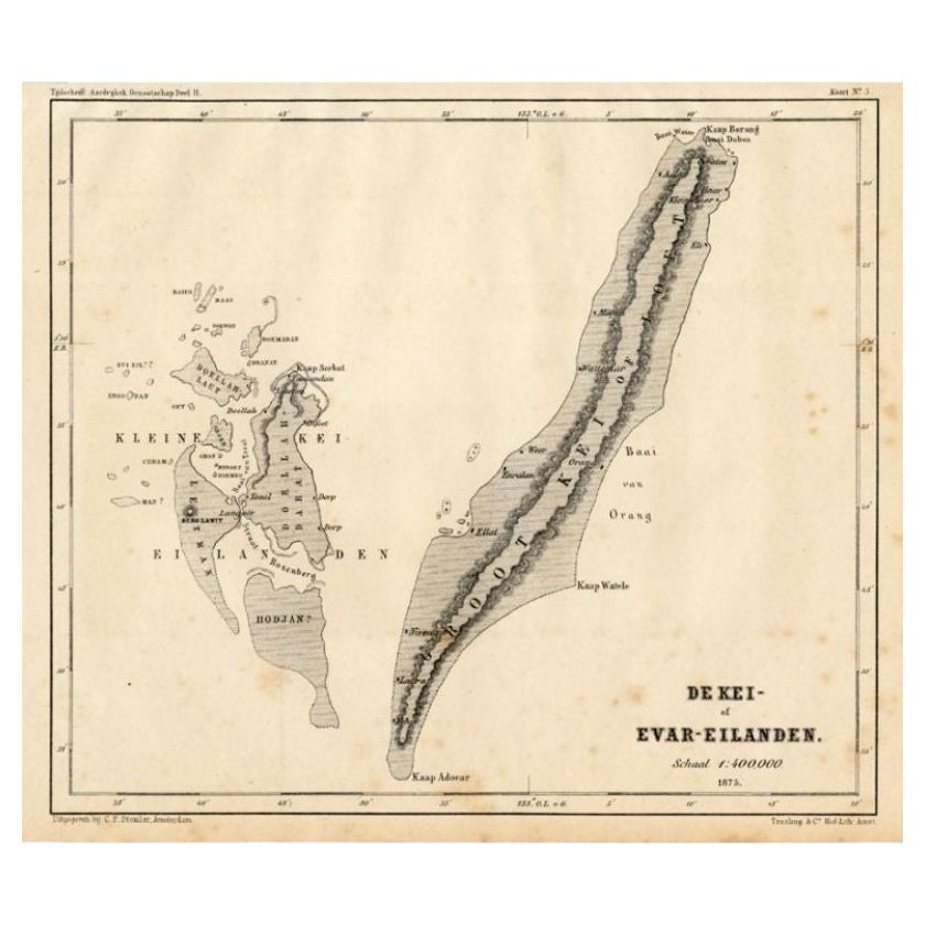
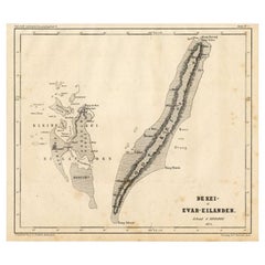
- Antique Map of the Kai Islands by Stemler, c.1875Located in Langweer, NLAntique map titled 'De Kei- of Evar eilanden.' (Kai Islands.) This map shows the Indonesian Kai Islands. Originates from 'Tijdschrift Aardrijkskundig Genootschap', published by C. F....Category
Antique 19th Century Maps
MaterialsPaper
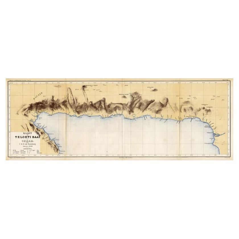
- Antique Map of Taluti Bay by Stemler, C.1875Located in Langweer, NLAntique map titled 'Kaart der Teloeti Baai op Ceram.' This scarce map shows the Taluti Bay on the Moluccan island of Ceram. Originates from 'Tijdschrift Aardrijkskundig Genootschap',...Category
Antique 19th Century Maps
MaterialsPaper
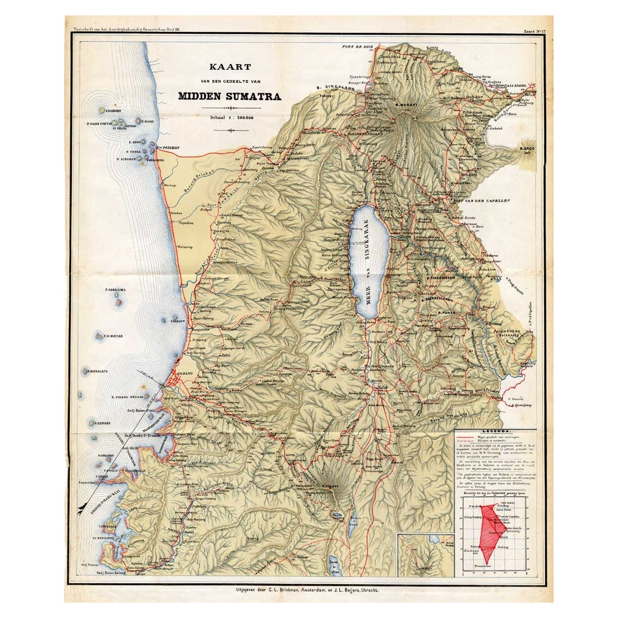
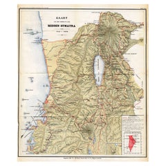
- Antique Map of Part of Sumatra by Stemler, c.1875Located in Langweer, NLAntique map titled 'Kaart van een gedeelte van Midden Sumatra.' This map shows a part of the Indonesian island of Sumatra. With legend. Originates from 'Tijdschrift Aardrijkskundig G...Category
Antique 19th Century Maps
MaterialsPaper
- Antique Map of the District of Boemi Agoeng by Stemler, c.1875Located in Langweer, NLAntique map titled 'Kaart van de Afdeling Boemi Agoeng.' This map shows the Indonesian district of Boemi Agoeng (Lampong districts). Originates from 'Tijdschrift Aardrijkskundig Geno...Category
Antique 19th Century Maps
MaterialsPaper
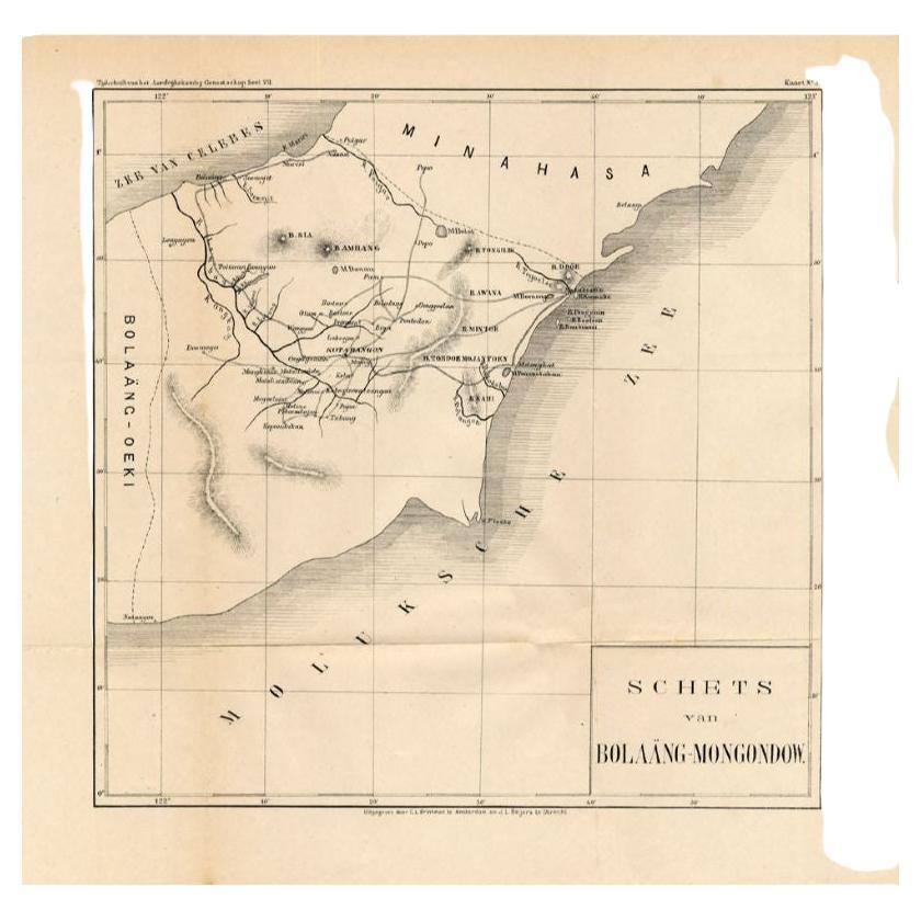
- Antique Map of the Bolaang Mongondow District on Sulawesi by Stemler, c.1875Located in Langweer, NLAntique map titled 'Schets van Bolaang-Mongondow.' This map shows the Bolaang Mongondow district on the Indonesian island of Sulawesi. Originates from 'Tijdschrift Aardrijkskundig Ge...Category
Antique 19th Century Maps
MaterialsPaper
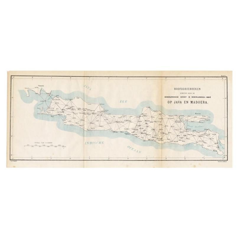
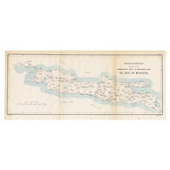
- Old Map of Java, Indonesia by Stemler, 1875By StemlerLocated in Langweer, NLAntique map titled 'Hoofddriehoeken - Java en madoera.' (Main triangles measured by the Geographical Service in the Dutch-Indies on Java and Madoera.) This scarce map shows the Indon...Category
Antique 19th Century Maps
MaterialsPaper


You May Also Like
- 1875 "North America" Map by J. BartholomewLocated in Colorado Springs, COPresented is an original 1875 map of “North America.” The map was issued in Volume 1 of the Ninth Edition of the Encyclopædia Britannica, published in Edinburgh. The map was drawn by famous Scottish mapmaker John Bartholomew. The map depicts North America, to include Greenland, the Dominion of Canada, the United States, Mexico, the countries of Central America, and the islands of the West Indies. Prominent rivers, mountain ranges, and cities are labeled on the map, and country borders are emphasized in red. The Encyclopædia Britannica has been published continuously since 1768, appearing in fifteen official editions. The landmark ninth edition of the Encyclopædia Britannica, often called "the Scholar's Edition," was published from January 1875 to 1889 in 25 volumes. The editor and author of the “Foreword” was Thomas Spencer Baynes, the first English-born editor after a series of Scots. After 1880, Baynes was assisted by William Robertson Smith. The 9th edition is often lauded as a high point among early editions for scholarship. The 9th edition was far more luxurious than any previously printed Encyclopædia Britannicas, with thick boards and quality leather bindings, premier paper, and a production which took full advantage of the technological advances of printing in the years between the 1850s and 1870s. The publishers took advantage of the new ability to print large graphic illustrations on the same pages as the text, as opposed to limiting illustrations to separate copper plate engravings. Although this technology had first been used in a primitive fashion the 7th edition, and to a much lesser extent in the 8th, in the 9th edition there were thousands of quality illustrations and maps set...Category
Antique 1870s Scottish Maps
MaterialsPaper
- 1861 Topographical Map of the District of Columbia, by Boschke, Antique MapLocated in Colorado Springs, COPresented is an original map of Albert Boschke's extremely sought-after "Topographical Map of the District of Columbia Surveyed in the Years 1856 ...Category
Antique 1860s American Historical Memorabilia
MaterialsPaper
- 1866 Ensign & Bridgman's Rail Road Map of the United StatesLocated in Colorado Springs, COPresented is an 1866 issue of “Ensign & Bridgeman’s Rail Road Map of the United States, showing Depots & Stations.” First published in 1856, this is the third edition, following anot...Category
Antique 1860s American Late Victorian Maps
MaterialsPaper
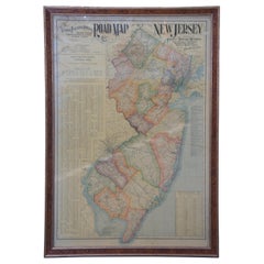
- 1903 Antique National Publishing Road Map of New Jersey Geological SurveyLocated in Dayton, OH1903 antique New Jersey road map by The National Publishing Company of Boston Massachusettes, No 384. Index for New Jersey Census 1900, Population 1...Category
Antique Early 1900s Victorian Maps
MaterialsPaper
- Antique 1901 National Publishing Company's Road Map of New Jersey GeologicalLocated in Dayton, OHThe National Publishing Company's road map of New Jersey, showing all county and township divisions, cities villages and post-offices, railroads, ste...Category
Antique Early 1900s Victorian Prints
MaterialsPaper
- Road Map Britannia No 32 the Road from London to Barnstable John Ogilby FramedBy John OgilbyLocated in BUNGAY, SUFFOLKA road map from Britannia, by John Ogilby Esq., Cosmographer and Geographick Printer to Charles II. Containing 293 miles. No 32. From Standard in Cornhill London to Andover thence to Amesbury, to Shruton, to Warminster, to Maiden-Bradley, to Bruton, to Weston, to Ascot and to Bridgewater Hand coloured, some foxing and creasing, commensurate with age. Floated in a cream mount with a gilded linear border within a burr walnut, ebonised and gilded frame. Provenance : purchased as pair from a collector with no 15 London to St Davids. Framed as a pair. Measures: Black Linear Border around Map Length 44cm., 17 1/8" Height 36cm., 14". Full Sheet Length 51cm., 20" Height 39cm., 15 1/4" Frame Length 62cm., 24 1/2 " Height 52cm., 20 1/2" Literature: In a remarkable life John Ogilby pursued, several careers, each ending in misfortune, and yet he always emerged undeterred, to carry on. His modern reputation is based on his final career, started in his sixty-sixth year, as a publisher of maps and geographical accounts. Ogilby was born outside Dundee, in 1600, the son of a Scottish gentleman. While he was still a child, the family moved to London. When the elder Ogilby was imprisoned for debt, the young John invested his savings in a lottery, won a minor prize, and settled his father's debts. Unfortunately, not enough money was left to secure John a good apprenticeship; instead, he was apprenticed to a dance master. Ogilby was soon dancing in masques at court but, one day, while executing a particularly ambitious leap, he landed badly. The accident left him with a permanent limp, and ended his dancing career. However, he had come to the attention of Thomas Wentworth, later Earl of Strafford, Charles I's most senior minister. Ever one to exploit his contacts, Ogilby became a dance instructor in Strafford's household. When Strafford was sent to Ireland, Ogilby accompanied him as Deputy-Master of the Kings Revels, and then Master of Revels. In Dublin, he built the New Theatre, in St. Werburgh Street, which prospered at first, but the Irish Rebellion, in 1641, cost Ogilby his fortune, which he estimated at £2,000, and almost his life. After brief service as a soldier, he returned to England, survived shipwreck on the way, and arrived back penniless. On his return, Ogilby turned his attention to the Latin classics, as a translator and publisher. His first faltering attempt, in 1649, was a translation of the works of Virgil, but after his marriage to a wealthy widow the same year, his publishing activities received a considerable boost. One means by which Ogilby financed these volumes was by subscription, securing advance payments from his patrons, in return for including their name and coats-of-arms on the plates of illustrations. Another approach was to secure a patron, preferably in the court circle. Ogilby's first patron was Strafford, who found out too late that all leading ministers are dispensable when Charles I assented to his execution in 1641. As he re-established himself, Ogilby sought a new patron, the King himself. In 1661, Ogilby was approached to write poetry for Charles II's coronation procession; he later published 'The Relation of His Majesties Entertainment Passing Through the City of London', and a much enlarged edition the following year, which included a Fine set of plates depicting the procession. Royal favour was bestowed in 1674 when John Ogilby received the title of 'His Majesty's Cosmographer and Geographick Printer' with a salary of £13.6s.8d per annum. In 1665, Ogilby left London to avoid the Plague then ravaging the capital. The following year, in the Great Fire of London, Ogilby claimed that he lost his entire stock of books valued at some £3,000, as well as his shop and house, leaving him worth just £5. As he sought to restore his fortunes, Ogilby was already looking in new directions. The initial opportunity he seized on was the reconstruction of London's burnt-out centre. He secured appointment as a 'sworn viewer', whose duty was to establish the property boundaries as they existed before the Fire. Ogilby was assisted in the project by his step-grandson, William Morgan...Category
Antique Late 17th Century English Charles II Maps
MaterialsPaper


Recently Viewed
View AllMore Ways To Browse
C F Modern
Antique Railroad Maps
Antique Florida Collectibles
Relief Map
West Coat Of Arms
Antique Map New York City
Antique Maps Of New York City
Antique New York City Maps
Map Of Massachusetts
Antique Tasmania
Antique Furniture Missouri
Maritime Chart
Southeast Asia Map
Biblical Maps
Church Yard
Migeon And Migeon
Migeon Migeon
1785 Maps