Items Similar to Antique Map of the Province of Overijssel by Keizer & De Lat, 1788

Want more images or videos?
Request additional images or videos from the seller
1 of 5
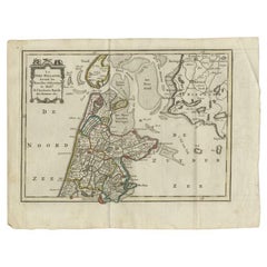
Antique Map of the Province of Overijssel by Keizer & De Lat, 1788
About the Item
Antique map titled 'Seigneurie d'Over-Ysel'. Uncommon antique map of the province of Overijssel, the Netherlands. This map originates from 'Nieuwe Natuur- Geschied- en Handelkundige Zak- en Reisatlas' by Gerrit Brender à Brandis.
Artists and Engravers: Published by J. Keizer and I. de Lat, 1788.
Condition: General age-related toning. Original folding lines. Original/contemporary hand coloring, blank verso. Minor wear, please study image carefully.
Date: 1788
Overall size: 26 x 21 cm.
Image size: 21.5 x 16.5 cm.
We sell original antique maps to collectors, historians, educators and interior decorators all over the world. Our collection includes a wide range of authentic antique maps from the 16th to the 20th centuries. Buying and collecting antique maps is a tradition that goes back hundreds of years. Antique maps have proved a richly rewarding investment over the past decade, thanks to a growing appreciation of their unique historical appeal. Today the decorative qualities of antique maps are widely recognized by interior designers who appreciate their beauty and design flexibility. Depending on the individual map, presentation, and context, a rare or antique map can be modern, traditional, abstract, figurative, serious or whimsical. We offer a wide range of authentic antique maps for any budget.
- Dimensions:Height: 8.27 in (21 cm)Width: 10.24 in (26 cm)Depth: 0 in (0.01 mm)
- Materials and Techniques:
- Period:
- Date of Manufacture:1788
- Condition:
- Seller Location:Langweer, NL
- Reference Number:
About the Seller
5.0
Platinum Seller
These expertly vetted sellers are 1stDibs' most experienced sellers and are rated highest by our customers.
Established in 2009
1stDibs seller since 2017
1,960 sales on 1stDibs
Typical response time: <1 hour
- ShippingRetrieving quote...Ships From: Langweer, Netherlands
- Return PolicyA return for this item may be initiated within 14 days of delivery.
More From This SellerView All
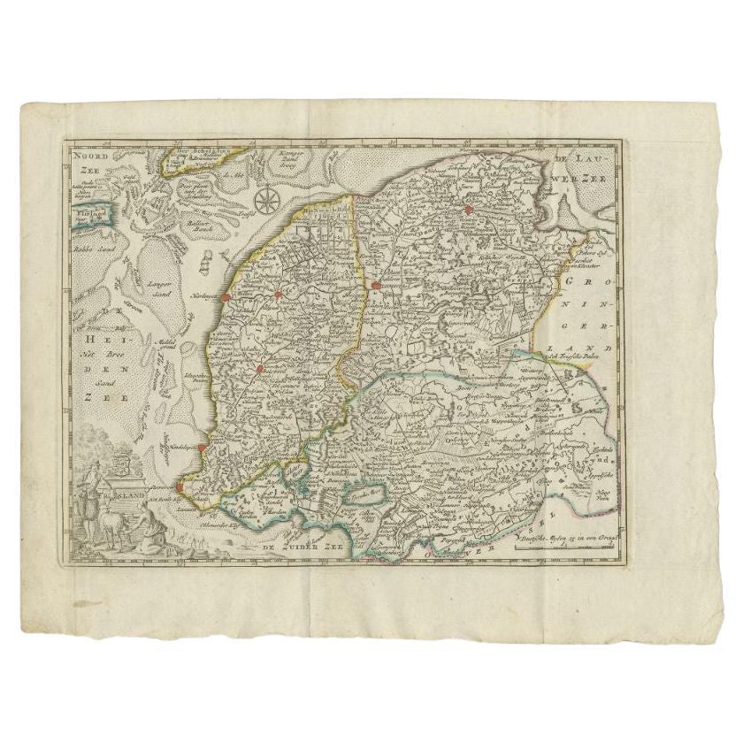
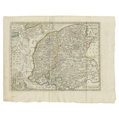
- Antique Map of the Province of Friesland by Keizer & De Lat, 1788Located in Langweer, NLAntique map titled 'Friesland'. Uncommon antique map of the province of Friesland, the Netherlands. This map originates from 'Nieuwe Natuur- Geschied- en Handelkundige Zak- en Reisat...Category
Antique 18th Century Maps
MaterialsPaper
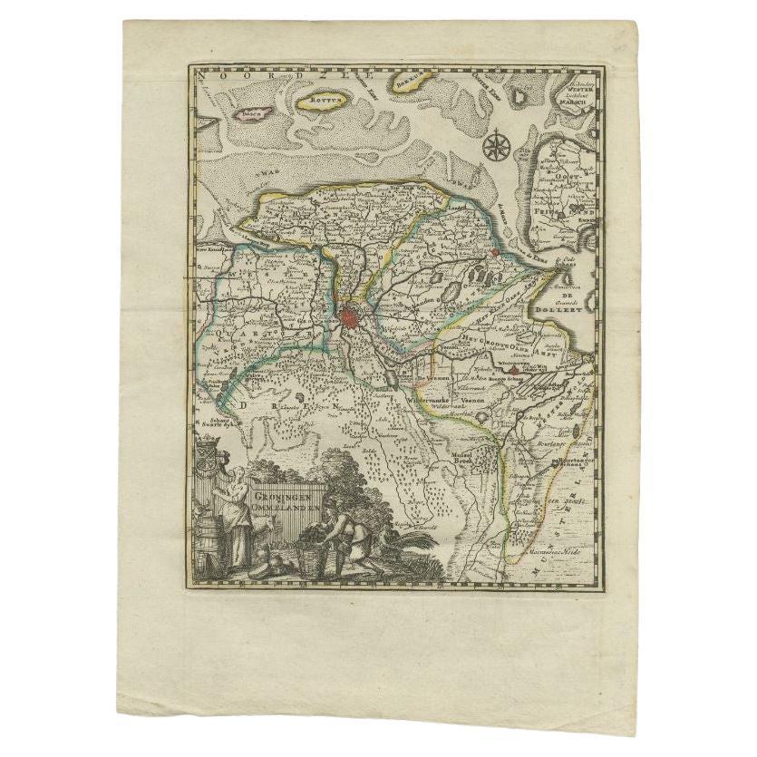
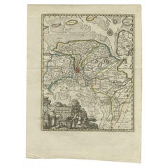
- Antique Map of the Province of Groningen by Keizer & De Lat, 1788Located in Langweer, NLAntique map titled 'Groningen en Ommelanden'. Uncommon antique map of the province of Groningen, the Netherlands. This map originates from 'Nieuwe Natuur- Geschied- en Handelkundige ...Category
Antique 18th Century Maps
MaterialsPaper
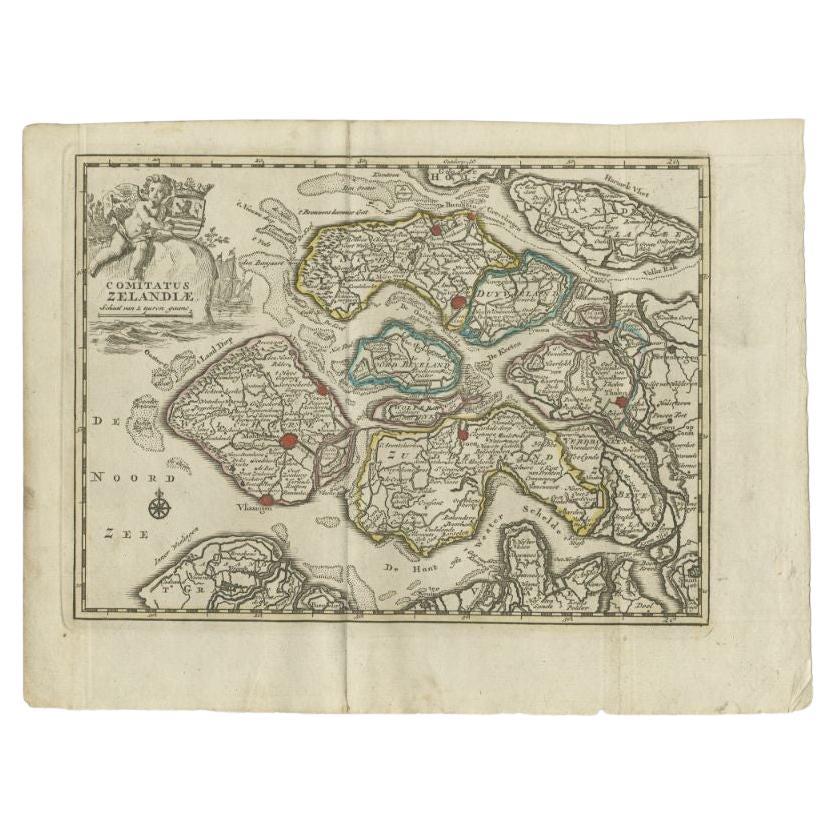
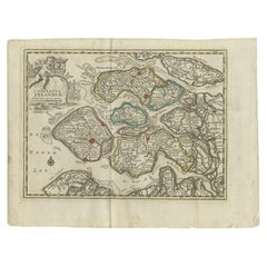
- Antique Map of the Province of Zeeland by Keizer & De Lat, 1788Located in Langweer, NLAntique map titled 'Comitatus Zelandiae'. Uncommon antique map of the province of Zeeland, the Netherlands. This map originates from 'Nieuwe Natuur- Geschied- en Handelkundige Zak- e...Category
Antique 18th Century Maps
MaterialsPaper
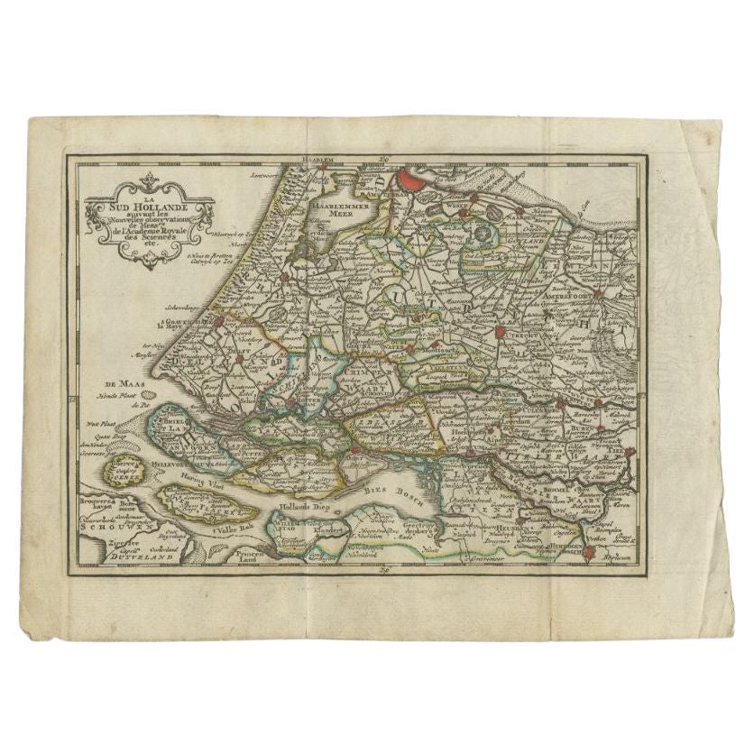
- Antique Map of the Province of Zuid-Holland by Keizer & De Lat, 1788Located in Langweer, NLAntique map titled 'La Sud Hollande (..)'. Uncommon antique map of the province of Zuid-Holland, the Netherlands. This map originates from 'Nieuwe Natuur- Geschied- en Handelkundige ...Category
Antique 18th Century Maps
MaterialsPaper
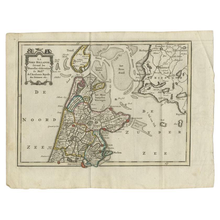
- Antique Map of the Province of Noord-Holland by Keizer & De Lat, 1788Located in Langweer, NLAntique map titled 'La Nord Hollande (..)'. Uncommon antique map of the province of Noord-Holland, the Netherlands. This map originates from 'Nieuwe Natuur- Geschied- en Handelkundig...Category
Antique 18th Century Maps
MaterialsPaper
- Antique Map of Europe by Keizer & de Lat, 1788Located in Langweer, NLAntique map titled 'Kaartje van Europa (..)'. Uncommon original antique map of Europe. This map originates from 'Nieuwe Natuur- Geschied- en Handelkundige Zak- en Reisatlas' by Gerri...Category
Antique Late 18th Century Maps
MaterialsPaper


You May Also Like
- Antique 18th Century Map of the Province of Pensilvania 'Pennsylvania State'Located in Philadelphia, PAA fine antique of the colony of Pennsylvania. Noted at the top of the sheet as a 'Map of the province of Pensilvania'. This undated and anonymous map is thought to be from the Gentleman's Magazine, London, circa 1775, although the general appearance could date it to the 1760's. The southern boundary reflects the Mason-Dixon survey (1768), the western boundary is placed just west of Pittsburgh, and the northern boundary is not marked. The map has a number of reference points that likely refer to companion text and appear to be connected to boundaries. The western and southern boundaries are marked Q, R, S, for example. A diagonal line runs from the Susquehanna R to the Lake Erie P. A broken line marked by many letters A, B, N, O, etc., appears in the east. There are no latitude or longitude markings, blank verso. Framed in a shaped contemporary gilt wooden frame and matted under a cream colored matte. Bearing an old Graham Arader Gallery...Category
Antique 18th Century British American Colonial Maps
MaterialsPaper
- 1861 Topographical Map of the District of Columbia, by Boschke, Antique MapLocated in Colorado Springs, COPresented is an original map of Albert Boschke's extremely sought-after "Topographical Map of the District of Columbia Surveyed in the Years 1856 ...Category
Antique 1860s American Historical Memorabilia
MaterialsPaper
- Original Antique Map of The World by Thomas Clerk, 1817Located in St Annes, LancashireGreat map of The Eastern and Western Hemispheres On 2 sheets Copper-plate engraving Drawn and engraved by Thomas Clerk, Edinburgh. Published by Mackenzie And Dent, 1817 ...Category
Antique 1810s English Maps
MaterialsPaper
- Antique Carte de L'Inde Myanmar, Malaysia Vietnam Map of Asia the Chinese EmpireLocated in Amsterdam, Noord HollandAntique Carte de L'Inde Myanmar, Malaysia Vietnam Map of Asia the Chinese Empire Very nice map of Asia. Additional information: Type: Map Country of Man...Category
Antique 18th Century European Maps
MaterialsPaper
- Map of the Holy Land "Carte de la Syrie et de l'Egypte" by Pierre M. LapieBy Pierre M. LapieLocated in Alamo, CAAn early 19th century map of ancient Syria and Egypt entitled "Carte de la Syrie et de l'Egypte anciennes/dressée par M. Lapie, Colonel d'Etat Major, et...Category
Antique Early 19th Century French Maps
MaterialsPaper
- 1907 Map of Colorado, Antique Topographical Map, by Louis NellLocated in Colorado Springs, COThis highly detailed pocket map is a topographical map of the state of Colorado by Louis Nell from 1907. The map "has been complied from all availabl...Category
Antique Early 1900s American Maps
MaterialsPaper


Recently Viewed
View AllMore Ways To Browse
Antique Stand Up Scale
Antique Railroad Collectables
Antique Railroad Collectibles Collectibles
Antique Railroad Collectibles
Maps Of Georgia
South Africa Antique Map
Antique Georgia Map
Antique Georgia Maps
Map Nautical Chart
Map New Amsterdam
18th Century Antique Mexican
Albanian Antique
East Africa Map
Antique Map Brazil
Antique Map Of Brazil
Antique Maps Persia
Antique Pirate
James Johnston