Items Similar to Antique Carte de L'Inde Myanmar, Malaysia Vietnam Map of Asia the Chinese Empire

Want more images or videos?
Request additional images or videos from the seller
1 of 5
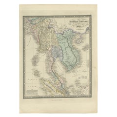
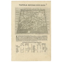
Antique Carte de L'Inde Myanmar, Malaysia Vietnam Map of Asia the Chinese Empire
About the Item
Antique Carte de L'Inde Myanmar, Malaysia Vietnam Map of Asia the Chinese Empire
Very nice map of Asia.
Additional information:
Type: Map
Country of Manufacturing: Europe
Period: 18th century Qing (1661 - 1912)
Condition: Overall Condition A (Good): Some trace of use.
Dimension: 410 Wx 307 H cm
- Dimensions:Height: 12.09 in (30.7 cm)Width: 16.15 in (41 cm)Depth: 0.04 in (1 mm)
- Materials and Techniques:
- Place of Origin:
- Period:
- Date of Manufacture:18th Century
- Condition:Overall Condition A (Good): Some trace of use.
- Seller Location:Amsterdam, NL
- Reference Number:
About the Seller
5.0
Gold Seller
These expertly vetted sellers are highly rated and consistently exceed customer expectations.
Established in 2015
1stDibs seller since 2019
158 sales on 1stDibs
Typical response time: 8 hours
- ShippingRetrieving quote...Ships From: Amsterdam, Netherlands
- Return PolicyA return for this item may be initiated within 14 days of delivery.
More From This SellerView All
- Super Rare Antique French Map of Chine and the Chinese Empire, 1780Located in Amsterdam, Noord HollandSuper Rare Antique French Map of Chine and the Chinese Empire, 1780 Very nice map of Asia. 1780 Made by Bonne. Additional information: Type: Map ...Category
Antique 18th Century European Maps
MaterialsPaper
- Antique French Map of Asia Including China Indoneseia India, 1783Located in Amsterdam, Noord HollandVery nice map of Asia. 1783 Dedie au Roy. Additional information: Country of Manufacturing: Europe Period: 18th century Qing (1661 - 1912) Condition: Overall Condition B (Good Used)...Category
Antique 18th Century European Maps
MaterialsPaper
- Antique 1803 Italian Map of Asia Including China Indoneseia IndiaLocated in Amsterdam, Noord HollandAntique 1803 Italian Map of Asia Including China Indoneseia India Very nice map of Asia. 1803. Additional information: Type: Map Country of Manufacturing: Europe Period: 19th centu...Category
Antique 19th Century European Maps
MaterialsPaper
- Antique Carte de De la Perse Saudie Arabia UAE Turkey Qatar Bahrein, 1836Located in Amsterdam, Noord HollandAntique Carte de De la Perse Saudie Arabia UAE Turkey Qatar Bahrein, 1836 Very nice map of Middle East. Additional information: Material: Paper Typ...Category
Antique 18th Century European Maps
MaterialsPaper
- Antique Voc Print Holland Malaysia Old Map Melaka History, 1663Located in Amsterdam, Noord HollandFrom my own collection I offer this impressive Antique print of the city of Malakka A very interesting piece for collectors . It is an museum piece from the Dutch Institute of Orien...Category
Antique 17th Century European Paintings
MaterialsPaper
- Antique Chinese Tin Toy Chinese MS 705 Trolley Bus Shanghai-Rare, 1950/1960Located in Amsterdam, Noord HollandOne of the absolute rarest antique Chinese toys made. Antique Red China Tin Toy clockwork. Chinese MS 705 Trolley Bus Shanghai-Rare! Additional informatio...Category
20th Century Chinese Toys and Dolls
MaterialsPorcelain


You May Also Like
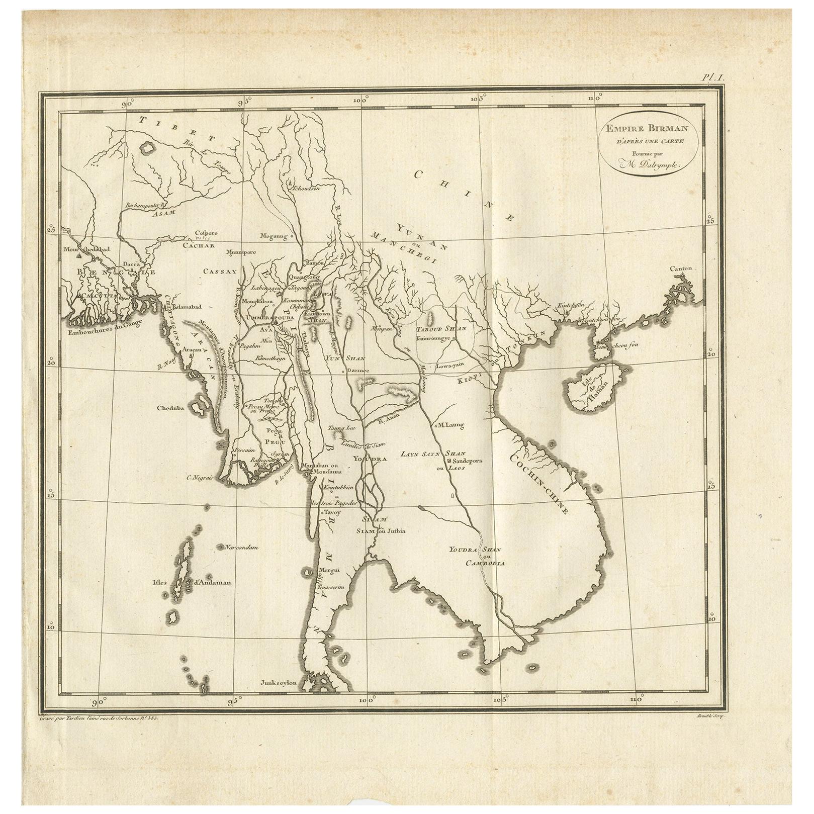
- Antique Map of the Burmese Empire by Symes, '1800'Located in Langweer, NLAntique map titled 'Empire Birman d'après une carte'. Map of the Burmese Empire. This map originates from 'Relation de l'Ambassade Anglaise, envoyée en 1795 dans le Royaume d'Ava, ou...Category
Antique Early 19th Century Maps
MaterialsPaper
- Antique Map of the Burmese Empire by Wyld, '1845'Located in Langweer, NLAntique map titled 'Map of Burman Empire, Siam, Cochin China and Ton-King'. Original antique map of the Burmese Empire. This map originates from 'An Atlas of the World, Comprehending...Category
Antique Mid-19th Century Maps
MaterialsPaper
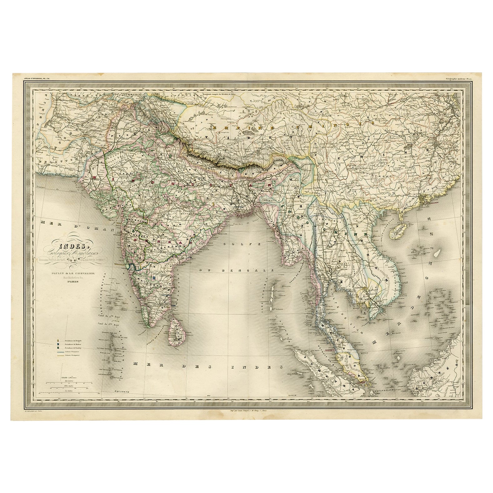
- Superb, Large Map of British India, Chinese Empire, Indochina, Malaysia, 1860Located in Langweer, NLAntique map titled 'Indes, colonies Anglaises.' Large map of the East Indies, British Colonies. A superb, large-scale map of British India, the Chinese Empire, Indochina, the Malay Peninsula, and parts of Sumatra and Borneo. This large original antique map originates from: 'Atlas Universel Physique, Historique et Politique de Geeographie Ancienne et Moderne ' by H. Dufour. Published 1860. Artists and Engravers: Made by 'Charles Dyonnet' after 'Dufour'. Charles Dyonnet (1822 - c. 1880) was an extremely active Paris based engraver working in the mid to late 19th century. From his offices at 220 Rue St. Jacques, Paris, Dyonnet engraved numerous maps for many of the most prominent 19th French cartographic publishers including Vuillemin, Dufour, Fremin and Duvotenay. From 1850-1861, he held the coveted position of 'Graveur du Depot de la Marine' and in this position engraved numerous French naval and military maps...Category
Antique 1860s Maps
MaterialsPaper
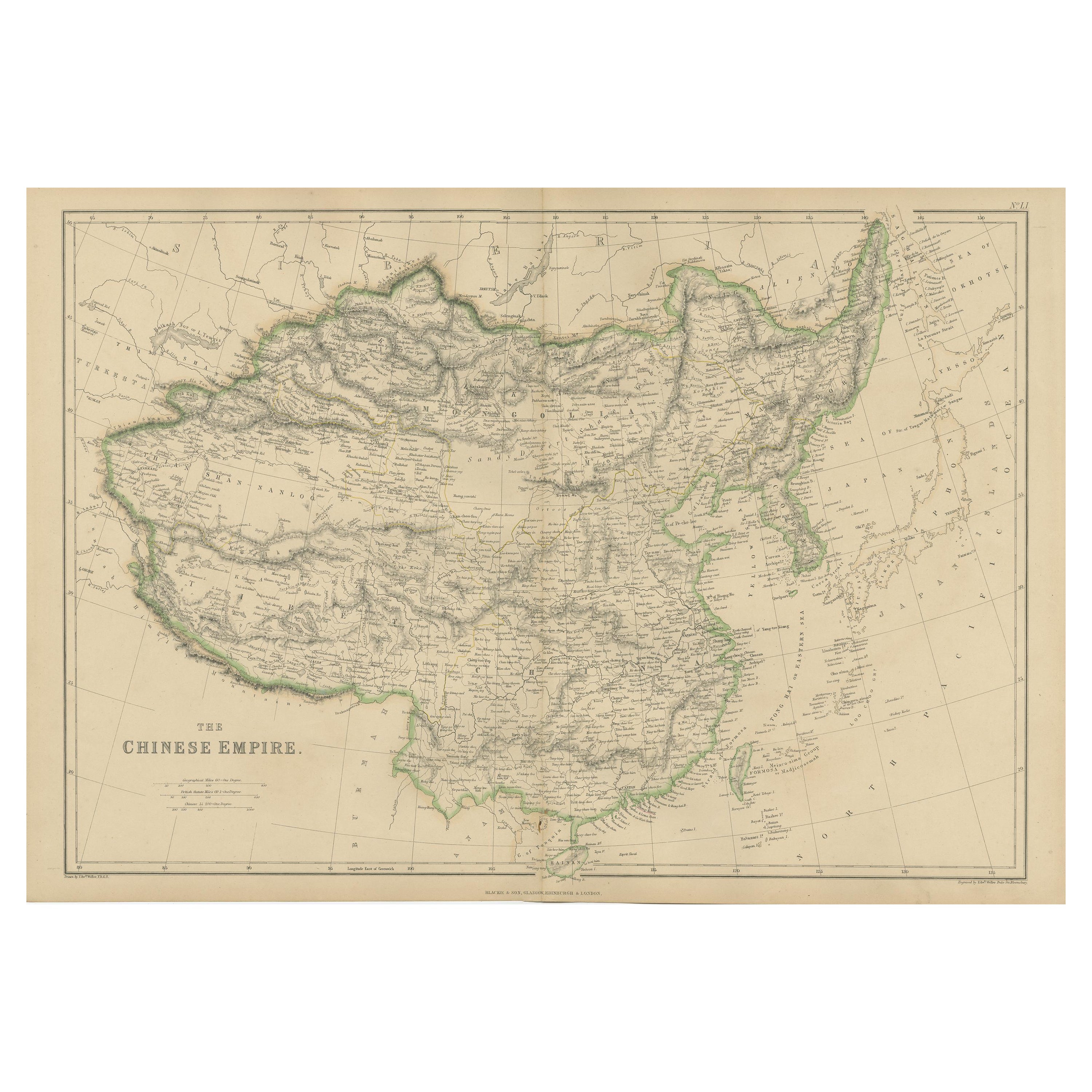
- Antique Map of the Chinese Empire by W. G. Blackie, 1859Located in Langweer, NLAntique map titled 'The Chinese Empire'. Original antique map of the Chinese Empire. This map originates from ‘The Imperial Atlas of Modern Geography’. Published by W. G. Blackie, 1859.Category
Antique Mid-19th Century Maps
MaterialsPaper
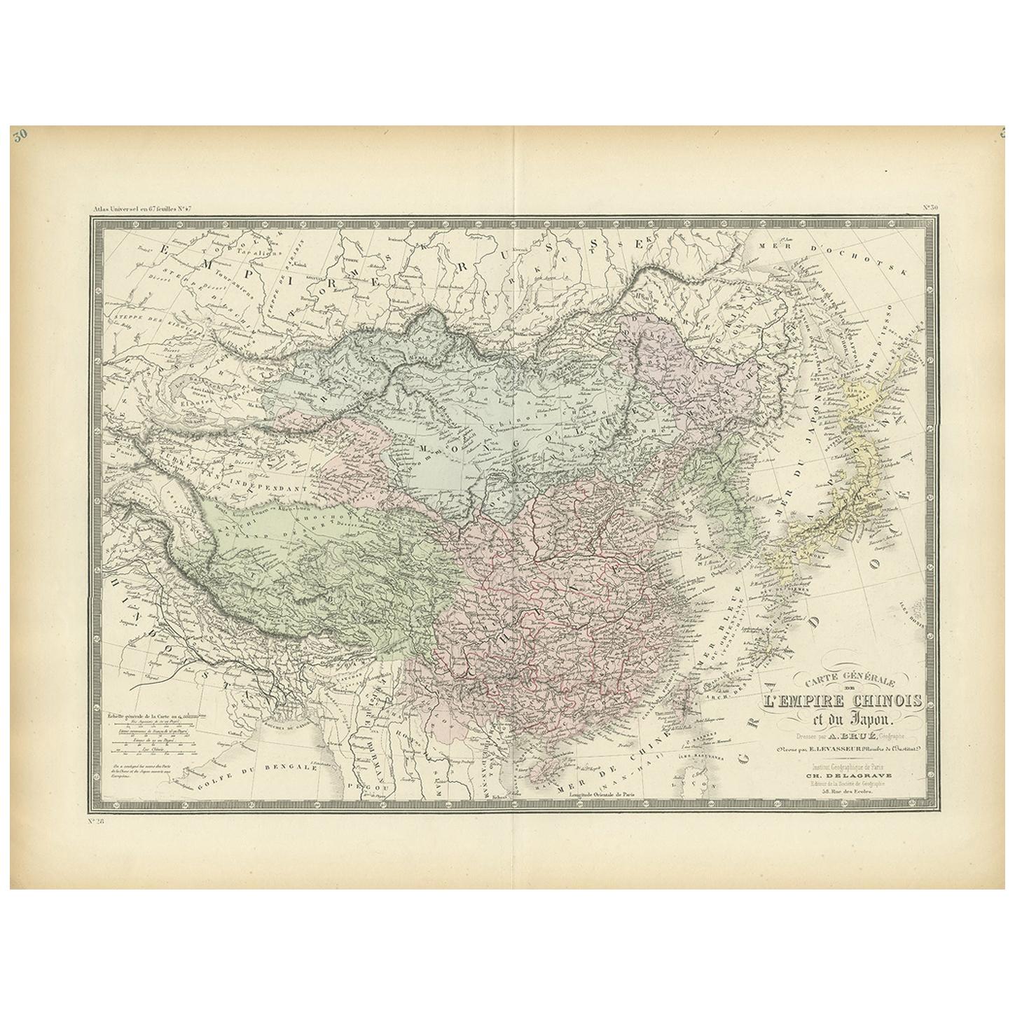
- Antique Map of the Chinese Empire and Japan, '1875'Located in Langweer, NLAntique map titled 'Carte générale de l'Empire Chinois et du Japon'. Large map of the Chinese Empire and Japan. This map originates from 'Atlas de Géographie Moderne Physique et Poli...Category
Antique Late 19th Century Maps
MaterialsPaper
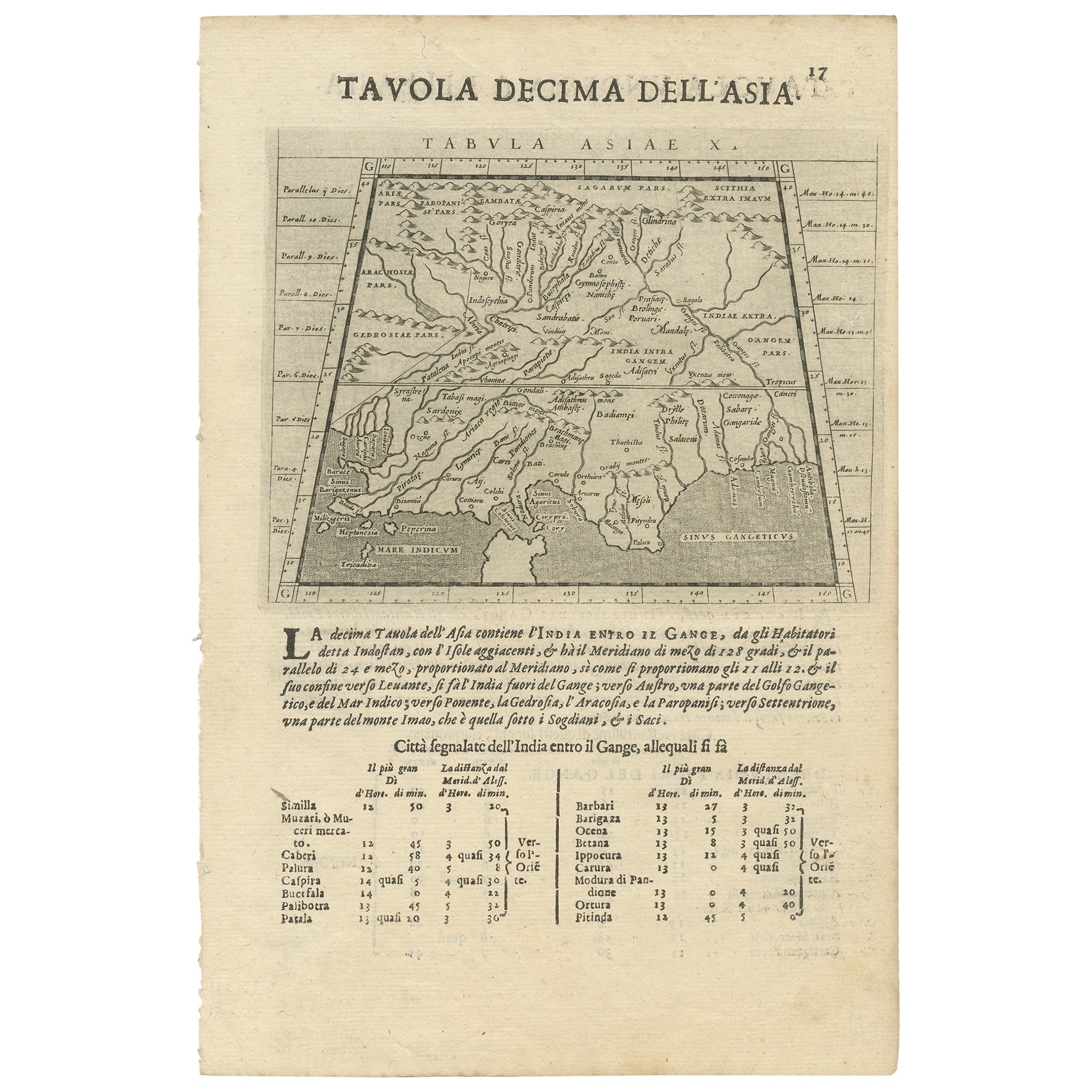
- Two Maps of Asia on One Sheet, India, Bangladesh and Malaysia & Burma etc., 1617Located in Langweer, NLAntique map titled 'Tabula Asiae'. Two maps of Asia on one sheet, recto and verso. The recto features an interesting map of India, Bangladesh and the Ganges River. On the verso, ...Category
Antique 1610s Maps
MaterialsPaper
Recently Viewed
View AllMore Ways To Browse
Antique Map Vietnam
18th Century European Maps
Ree Brown
Winkler Prins
Very Large Map
Antique American Victorian Furniture
A Plan City And Castle Of Batavia
Cheshire Map
John Speed Isle Of Wight Maps
Malacca Strait Map
Antique Map Of South Korea
Antique Compass France
Isle Of Wight Maps
Carl Probst
Guatemala Antique Map
Antique Maps Washington Dc
Cyclades Map
Dao Antique Map