Items Similar to Antique Carte de De la Perse Saudie Arabia UAE Turkey Qatar Bahrein, 1836

Want more images or videos?
Request additional images or videos from the seller
1 of 5
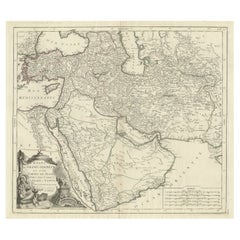
Antique Carte de De la Perse Saudie Arabia UAE Turkey Qatar Bahrein, 1836
About the Item
Antique Carte de De la Perse Saudie Arabia UAE Turkey Qatar Bahrein, 1836
Very nice map of Middle East.
Additional information:
Material: Paper
Type: Map
Region of Origin: Europe
Period: 18th century Qing (1661 - 1912)
Age: 18th century
Original/Reproduction: Original
Condition: Overall Condition A (Good): Some trace of use.
Dimension: 410 W x 307 H cm
- Dimensions:Height: 12.09 in (30.7 cm)Width: 16.15 in (41 cm)Depth: 0.04 in (1 mm)
- Materials and Techniques:
- Place of Origin:
- Period:
- Date of Manufacture:18th Century
- Condition:Overall Condition A (Good): Some trace of use.
- Seller Location:Amsterdam, NL
- Reference Number:
About the Seller
5.0
Gold Seller
These expertly vetted sellers are highly rated and consistently exceed customer expectations.
Established in 2015
1stDibs seller since 2019
158 sales on 1stDibs
Typical response time: 8 hours
- ShippingRetrieving quote...Ships From: Amsterdam, Netherlands
- Return PolicyA return for this item may be initiated within 14 days of delivery.
More From This SellerView All
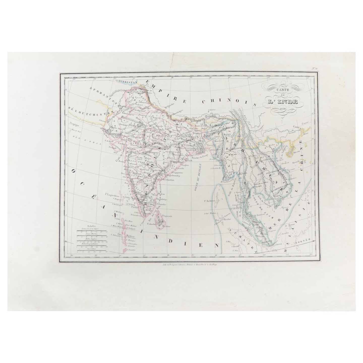
- Antique Carte de L'Inde Myanmar, Malaysia Vietnam Map of Asia the Chinese EmpireLocated in Amsterdam, Noord HollandAntique Carte de L'Inde Myanmar, Malaysia Vietnam Map of Asia the Chinese Empire Very nice map of Asia. Additional information: Type: Map Country of Man...Category
Antique 18th Century European Maps
MaterialsPaper
- Antique French Map of Asia Including China Indoneseia India, 1783Located in Amsterdam, Noord HollandVery nice map of Asia. 1783 Dedie au Roy. Additional information: Country of Manufacturing: Europe Period: 18th century Qing (1661 - 1912) Condition: Overall Condition B (Good Used)...Category
Antique 18th Century European Maps
MaterialsPaper
- Antique 1803 Italian Map of Asia Including China Indoneseia IndiaLocated in Amsterdam, Noord HollandAntique 1803 Italian Map of Asia Including China Indoneseia India Very nice map of Asia. 1803. Additional information: Type: Map Country of Manufacturing: Europe Period: 19th centu...Category
Antique 19th Century European Maps
MaterialsPaper
- Super Rare Antique French Map of Chine and the Chinese Empire, 1780Located in Amsterdam, Noord HollandSuper Rare Antique French Map of Chine and the Chinese Empire, 1780 Very nice map of Asia. 1780 Made by Bonne. Additional information: Type: Map ...Category
Antique 18th Century European Maps
MaterialsPaper
- Antique Chinese Tin Toy Car Mini Sedan MF152 Shanghai, 1950/1960Located in Amsterdam, Noord HollandOne of the absolute rarest antique Chinese toys made. This is a most unusually made antique toy from the 1950/1960s . A Mini sedan Shanghai car with the nr MF 152 Additional informa...Category
20th Century Chinese Toys and Dolls
MaterialsPorcelain
- Antique Chinese Calligraphy Ink Stones in Box Great Condition, ca 1900-1930Located in Amsterdam, Noord HollandAntique Chinese Calligraphy Ink Stones in Box Great Condition, ca 1900-1930. Very interesting Additional information: Type: Boxes Region ...Category
Antique 19th Century Chinese Nautical Objects
MaterialsPorcelain


You May Also Like
- 1860 Large Map "Carte De La Siberie Russie D'asie, " Ric.R0001Located in Norton, MALarge 1860 map "Carte De La Siberie Russie D'Asie," R-0001 " Authentic" - 1860 map "Carte De La Siberie Russie D'Asie," Dimension: Paper: 68 cm W x 51 cm H ; Sight: 51cm W x 4...Category
Antique 19th Century Unknown Maps
MaterialsPaper
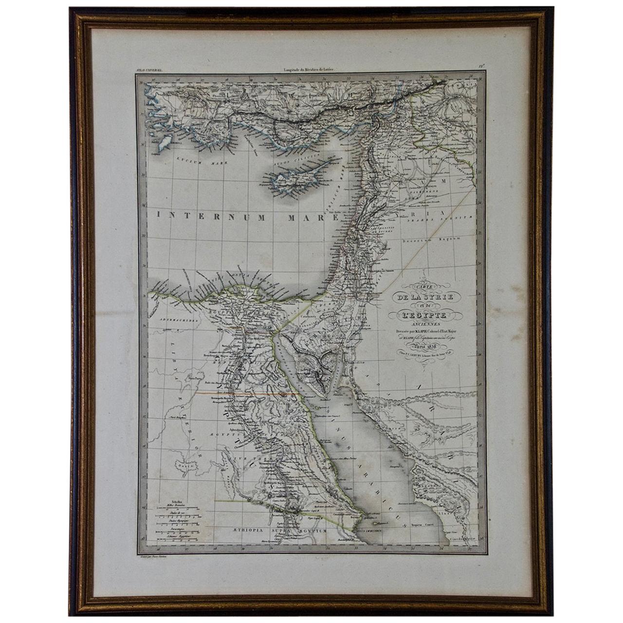
- Map of the Holy Land "Carte de la Syrie et de l'Egypte" by Pierre M. LapieBy Pierre M. LapieLocated in Alamo, CAAn early 19th century map of ancient Syria and Egypt entitled "Carte de la Syrie et de l'Egypte anciennes/dressée par M. Lapie, Colonel d'Etat Major, et...Category
Antique Early 19th Century French Maps
MaterialsPaper
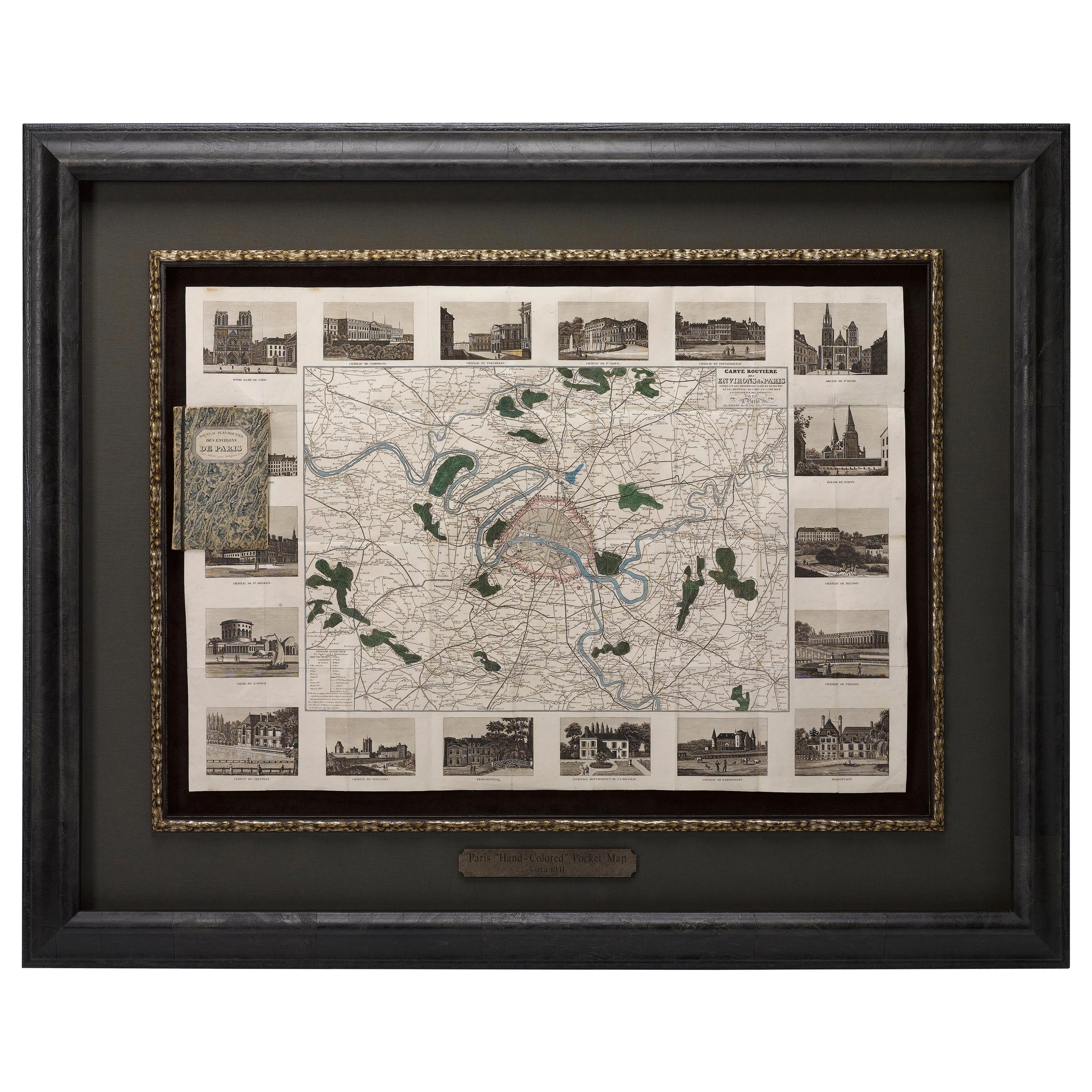
- Antique Map of Paris, "Carte Routiere des Environs de Paris" 1841Located in Colorado Springs, COThis beautiful hand-colored road map of Paris was published in 1841. The map shows Paris and the surrounding area in a folding pocket map. Organized and detailed for travelers, this ...Category
Antique 1840s French Maps
MaterialsPaper
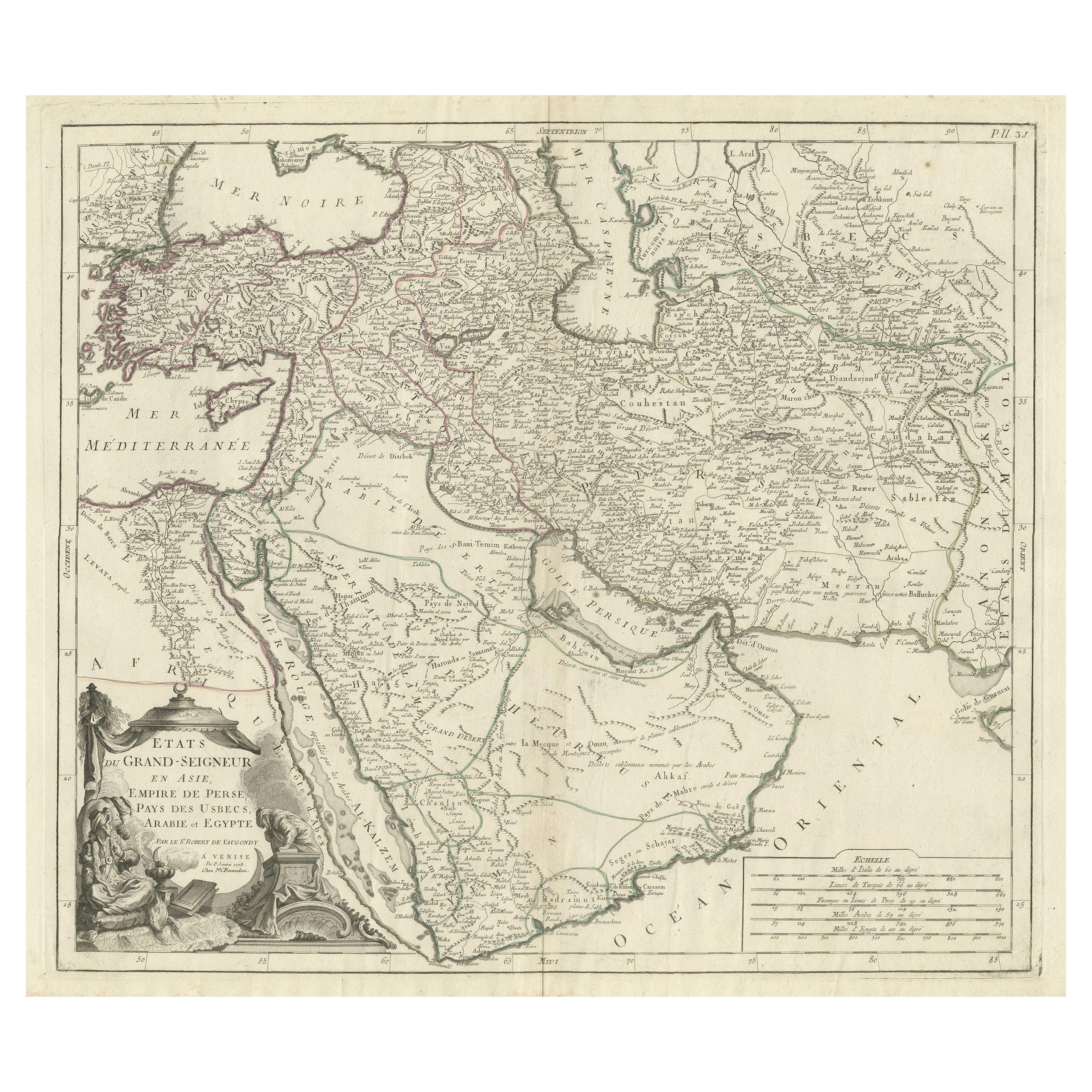
- Detailed Original Antique Map of the Turkish Empire with Arabia, 1778Located in Langweer, NLTitle: Etats Due Grand-Seigneur En Asie, Empire De Perse, Pays Des Usbecs, Arabie et Egypte . . . 1753 Detailed map of the Turkish Empire, extending to the Black Sea, Georgia, the...Category
Antique 1770s Maps
MaterialsPaper
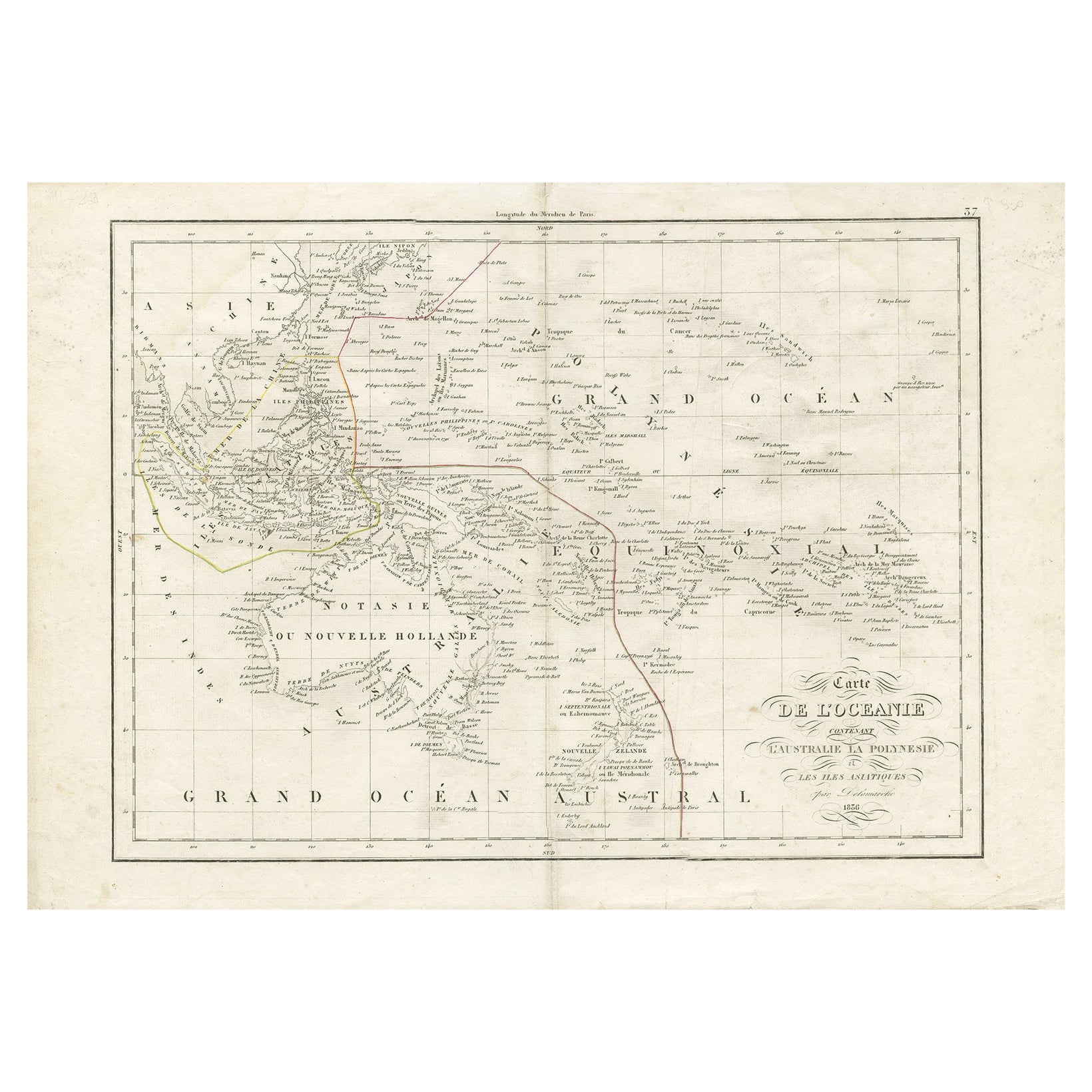
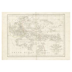
- Antique Map of Oceania by Delamarche, 1836Located in Langweer, NLAntique map titled 'Carte de l'Oceanie contenant l'Australie la Poynesie et les iles Asiatiques.' Antique map of Oceania comprising Australia and Polynesia, New Zealand and Indonesia...Category
Antique 19th Century Maps
MaterialsPaper
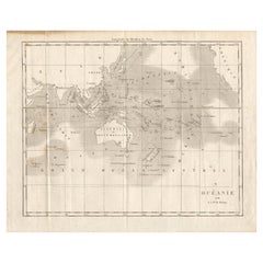
- Antique Map of Oceania by Didot, 1836Located in Langweer, NLAntique map titled 'Oceanie par G.L.Dy. De Rienzi'. Map of the Oceania region, around Australia. This print originates from M.G.L. Domeny de Rienzi's 'Oceanie, ou Cinquieme Partie du...Category
Antique 19th Century Maps
MaterialsPaper


Recently Viewed
View AllMore Ways To Browse
Ree Brown
Winkler Prins
Very Large Map
Antique American Victorian Furniture
A Plan City And Castle Of Batavia
Cheshire Map
John Speed Isle Of Wight Maps
Malacca Strait Map
Antique Map Of South Korea
Antique Compass France
Isle Of Wight Maps
Carl Probst
Guatemala Antique Map
Antique Maps Washington Dc
Cyclades Map
Dao Antique Map
Eso Antique Maps
Map Of Charlevoix