Items Similar to Antique Map of Southern Greece, 1892


Want more images or videos?
Request additional images or videos from the seller
1 of 5
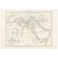
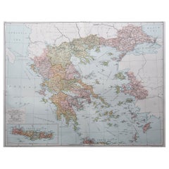
Antique Map of Southern Greece, 1892
About the Item
Antique map of Greece titled 'Griechenland. Südlicher Theil'. Old map of Southern Greece with inset maps of the Acropolis of Athens, the region of Athens, Thermopylae and Olympia. Source unknown, to be determined.
Condition: Good, general age-related toning. Repair on on folding line, please study image carefully.
Date: c.1892
Overall size: 30.5 x 25.5 cm.
Image size: 29 x 22.5 cm.
We sell original antique maps to collectors, historians, educators and interior decorators all over the world. Our collection includes a wide range of authentic antique maps from the 16th to the 20th centuries. Buying and collecting antique maps is a tradition that goes back hundreds of years. Antique maps have proved a richly rewarding investment over the past decade, thanks to a growing appreciation of their unique historical appeal. Today the decorative qualities of antique maps are widely recognized by interior designers who appreciate their beauty and design flexibility. Depending on the individual map, presentation, and context, a rare or antique map can be modern, traditional, abstract, figurative, serious or whimsical. We offer a wide range of authentic antique maps for any budget.
- Dimensions:Height: 10.04 in (25.5 cm)Width: 12.01 in (30.5 cm)Depth: 0.01 in (0.2 mm)
- Materials and Techniques:
- Period:
- Date of Manufacture:circa 1892
- Condition:
- Seller Location:Langweer, NL
- Reference Number:
About the Seller
5.0
Platinum Seller
These expertly vetted sellers are 1stDibs' most experienced sellers and are rated highest by our customers.
Established in 2009
1stDibs seller since 2017
1,933 sales on 1stDibs
Typical response time: <1 hour
- ShippingRetrieving quote...Ships From: Langweer, Netherlands
- Return PolicyA return for this item may be initiated within 14 days of delivery.
More From This SellerView All
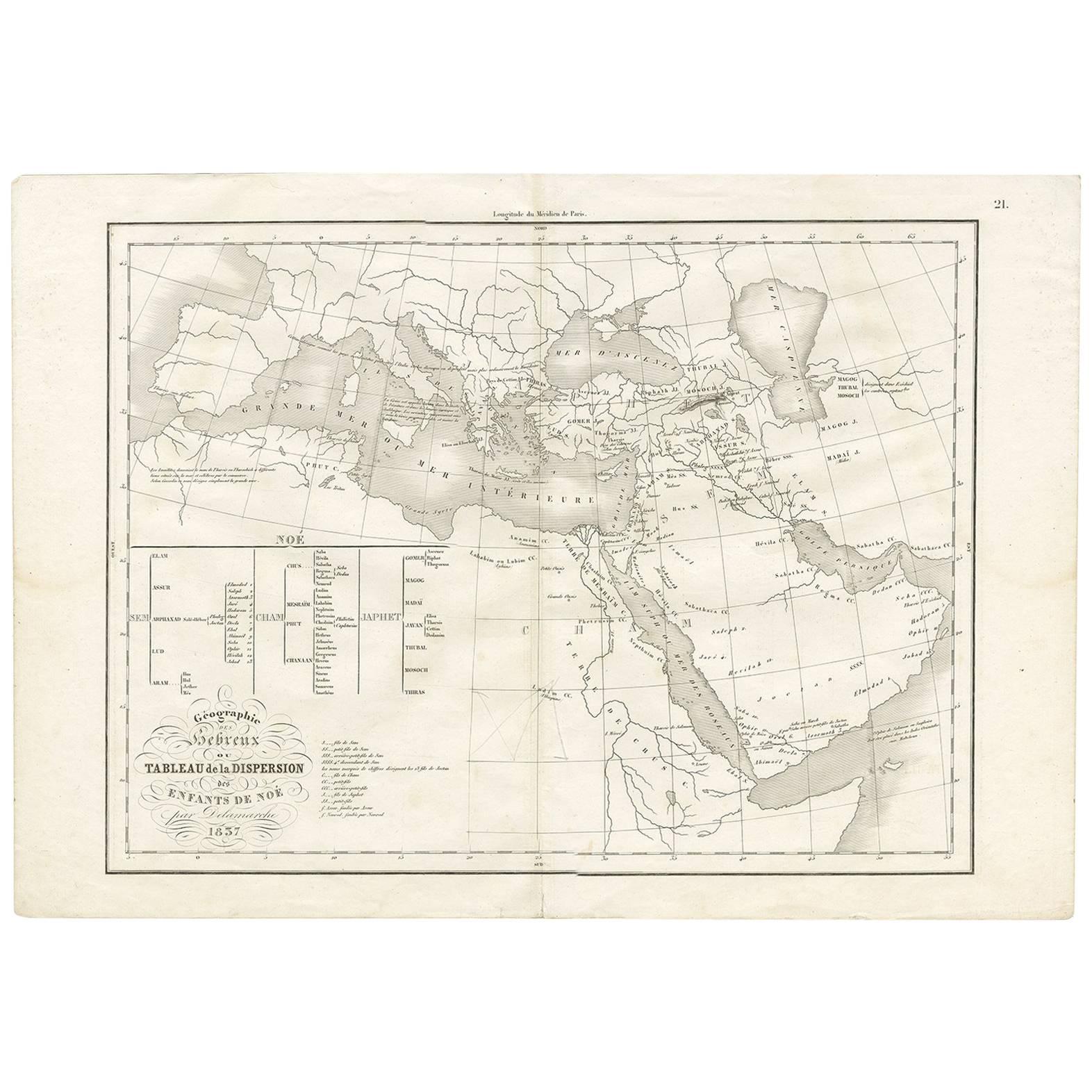
- Antique Map of Southern Europe by F. Delamarche, 1837Located in Langweer, NLTitle: Géographie des Hébreux ou Tableau de la Dispersion des enfants de Noé - **Origin**: From 'Atlas De La Géographie Ancienne' by F. Delamarche - **Date of Publication**: 1837 D...Category
Antique Mid-19th Century Maps
MaterialsPaper
- Antique Map of Southern Africa by Levasseur, 1875Located in Langweer, NLAntique map titled 'Afrique Méridionale'. Large map of Southern Africa. This map originates from 'Atlas de Géographie Moderne Physique et Politique' b...Category
Antique Late 19th Century Maps
MaterialsPaper
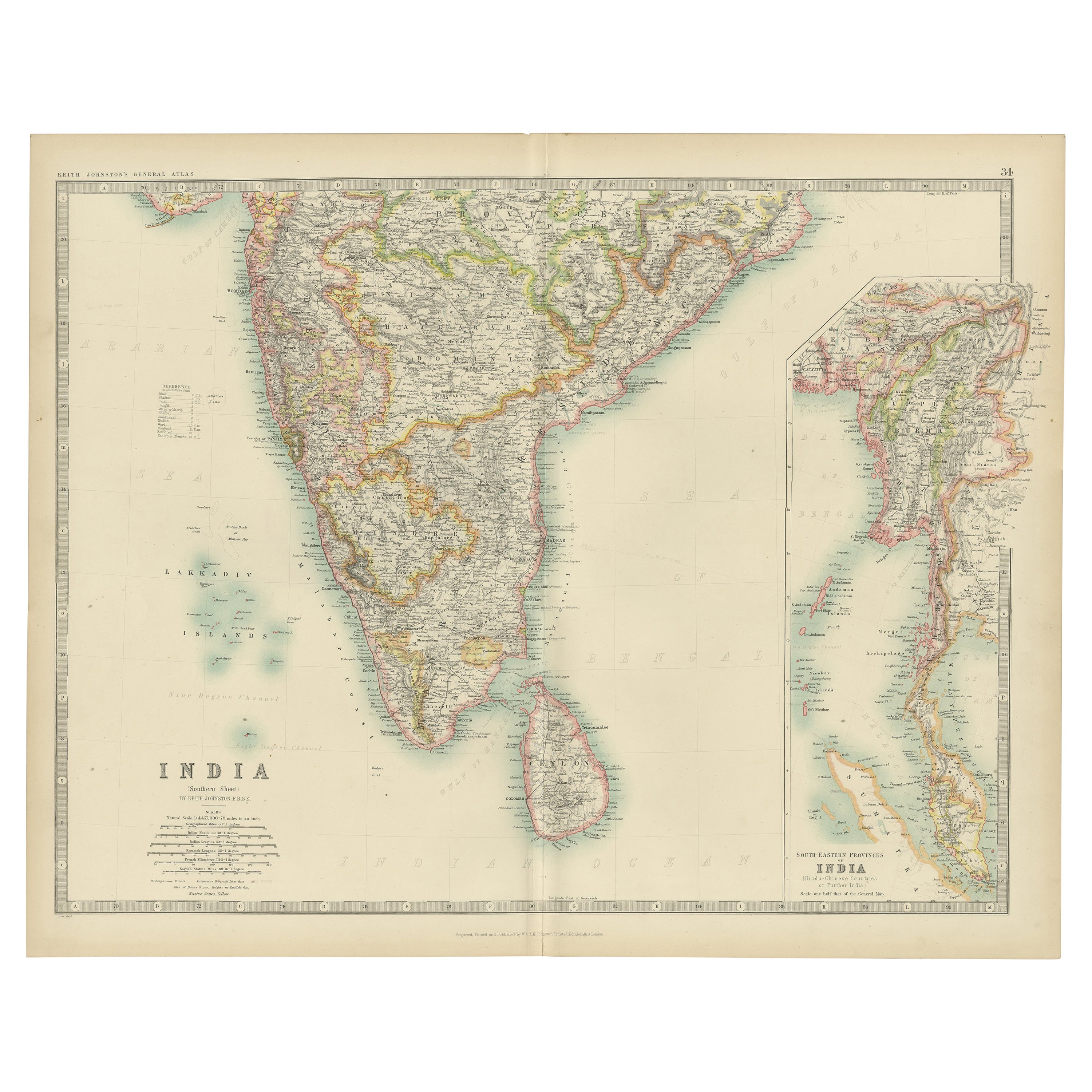
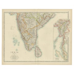
- Antique Map of India ( Southern ) by Johnston (1909)Located in Langweer, NLAntique map titled 'India'. Original antique map of India Southern sheet. With inset maps of south eastern provinces of India. This map originates from the ‘Royal Atlas of Modern Geo...Category
Early 20th Century Maps
MaterialsPaper
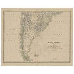
- Antique Map of South America, Southern Part, 1882Located in Langweer, NLAntique map titled 'South America'. Old map of South America. This map originates from 'The Royal Atlas of Modern Geography, Exhibiting, in a Series of Entirely Original and Authenti...Category
Antique 19th Century Maps
MaterialsPaper
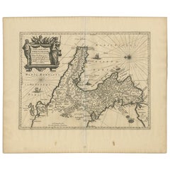
- Antique Map of Denmark and Southern Sweden, c.1658Located in Langweer, NLAntique map titled 'Royaume de Danemarq.' Map centered on Sjaelland and covers all of Denmark and part of southern Sweden where a dramatic title cartouche obscures the interior. Sour...Category
Antique 17th Century Maps
MaterialsPaper
- Antique Map of Southern Italy by Janssonius, C.1650Located in Langweer, NL"Antique map titled 'Itala nam tellus Graecia Maior erat Ovid. IV. Fastor. Haec Italiae pars nunc primum de prica aerugine est abstersa (..)'. Beautiful map of Southern Italy...Category
Antique 17th Century Maps
MaterialsPaper


You May Also Like
- Southern Greece: A Large 17th C. Hand-colored Map by Sanson and JaillotBy Nicolas SansonLocated in Alamo, CAThis large original hand-colored copperplate engraved map of southern Greece and the Pelopponese Peninsula entitled "La Moree Et Les Isles De Zante, Cefalonie, Ste. Marie, Cerigo & C...Category
Antique 1690s French Maps
MaterialsPaper
- Original Antique Map of Ancient Greece, Achaia, Corinth, 1786Located in St Annes, LancashireGreat map of Ancient Greece. Showing the region of Thessaly, including Mount Olympus Drawn by J.D. Barbie Du Bocage Copper plate engraving by P.F Tardieu Original hand color...Category
Antique 1780s French Other Maps
MaterialsPaper
- Original Antique Map of Ancient Greece- Boeotia, Thebes, 1787Located in St Annes, LancashireGreat map of Ancient Greece. Showing the region of Boeotia, including Thebes Drawn by J.D. Barbie Du Bocage Copper plate engraving by P.F T...Category
Antique 1780s French Other Maps
MaterialsPaper
- Original Antique Map of Ancient Greece, Phocis, Gulf of Corinth, 1787Located in St Annes, LancashireGreat map of Ancient Greece. Showing the region of Phocis, including the Gulf of Corinth Drawn by J.D. Barbie Du Bocage Copper plate engraving by P.F Tardieu Original hand c...Category
Antique 1780s French Other Maps
MaterialsPaper
- Large Original Vintage Map of Greece, circa 1920Located in St Annes, LancashireGreat map of Greece Original color. Good condition Published by Alexander Gross Unframed.Category
Vintage 1920s English Maps
MaterialsPaper
- Map Southern Scotland Thomas Conder Alex Hogg 1795Located in BUNGAY, SUFFOLKA new map of the southern part of Scotland containing the counties of Stirling, Lanerk, Renfrew, Linlithgow, Edinburgh, Peebles, Haddingtoun, Berwick, Selkirk, Roxburgh, Dumfries, Wigtoun, Kirkudbright & Air Published by Alex Hogg at the Kings Arms...Category
Antique 18th Century English Georgian Maps
MaterialsPaper


Recently Viewed
View AllMore Ways To Browse
Southern Furniture
Southern Used Furniture
Old Greek
Southern Antiques
Authentic Greek
Traditional Greek Furniture
Old World Antique Maps
Antique Old World Map
Old World Antique Map
Old Antique World Map
Greek Map
Map Greece
Map Of Greece
Used Furniture Olympia
Antique Maps Of Greece
Antique Map Of Greece
Antique Greek Map
Antique Greece Map