Items Similar to Antique Map of the Southern Netherlands by Bowles, c.1780
Want more images or videos?
Request additional images or videos from the seller
1 of 5
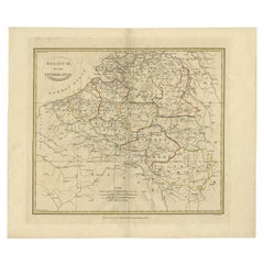
Antique Map of the Southern Netherlands by Bowles, c.1780
About the Item
Antique map titled ‘Bowles's New Pocket Map of the ten Catholick Provinces of the Lower Countries, or Netherlands’. Original antique map of the Southern Netherlands. The Southern Netherlands, also called the Catholic Netherlands, was the part of the Low Countries largely controlled by Spain (1556–1714), later Austria (1714–1794), and occupied then annexed by France (1794–1815). With English legend explaining the ten provinces.
Artists and Engravers: Thomas Bowles, born around 1712, was map publisher and seller in London. The business was continued by John and Carrington Bowles and finally under the name Bowles and Carver until early 19th century.
Condition: Good. General age-related toning and foxing. Please study image carefully.
Date: c.1780
Overall size: 68 x 54.5 cm.
Image size: 54 x 48 cm.
We sell original antique maps to collectors, historians, educators and interior decorators all over the world. Our collection includes a wide range of authentic antique maps from the 16th to the 20th centuries. Buying and collecting antique maps is a tradition that goes back hundreds of years. Antique maps have proved a richly rewarding investment over the past decade, thanks to a growing appreciation of their unique historical appeal. Today the decorative qualities of antique maps are widely recognized by interior designers who appreciate their beauty and design flexibility. Depending on the individual map, presentation, and context, a rare or antique map can be modern, traditional, abstract, figurative, serious or whimsical. We offer a wide range of authentic antique maps for any budget.
- Dimensions:Height: 21.46 in (54.5 cm)Width: 26.78 in (68 cm)Depth: 0 in (0.01 mm)
- Materials and Techniques:
- Period:
- Date of Manufacture:circa 1780
- Condition:
- Seller Location:Langweer, NL
- Reference Number:
About the Seller
5.0
Platinum Seller
These expertly vetted sellers are 1stDibs' most experienced sellers and are rated highest by our customers.
Established in 2009
1stDibs seller since 2017
1,946 sales on 1stDibs
Typical response time: <1 hour
- ShippingRetrieving quote...Ships From: Langweer, Netherlands
- Return PolicyA return for this item may be initiated within 14 days of delivery.
More From This SellerView All
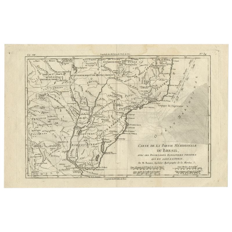
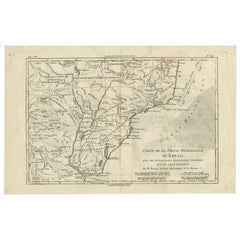
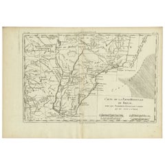
- Antique Map of Southern Brazil by Bonne, c.1780Located in Langweer, NL"Antique map titled 'Carte de la Partie Méridionale du Bresil (..)'. This antique map of Brazil depicts southern Brazil, Uruguay, and northern Argentina, including Rio de Janeiro, Montevideo, and Buenos Aires. Published by R. Bonne. Artists and Engravers: Rigobert Bonne (October 6, 1727 - September 2, 1794) was one of the most important French cartographers of the late 18th century. Bonne was born in Ardennes à Raucourt, France. He taught himself mathematics and by eighteen was a working engineer. During the War of the Austrian Succession...Category
Antique 18th Century Maps
MaterialsPaper
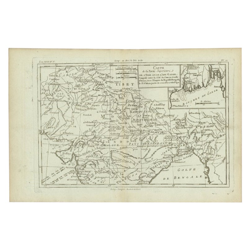
- Antique Map of Part of Southern Asia by Bonne, c.1780Located in Langweer, NLAntique map titled 'Carte de la Partie Superieure de l'Inde en deca du Gange. Comprise entre la Cote du Concan et celle d'Orixa, avec l'Empire du Mogol, le Bengale, le R. d'Asham, pa...Category
Antique 18th Century Maps
MaterialsPaper
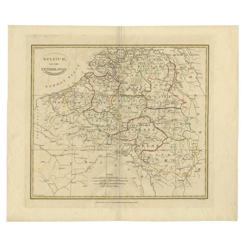
- Antique Map of Belgium and Part of the Southern Netherlands, 1810Located in Langweer, NLAntique map titled 'Belgium, or the Netherlands divided into Departments'. Original antique map of Belgium and the southern part of the Netherlands. This map originates from 'The Mod...Category
Antique 19th Century Maps
MaterialsPaper
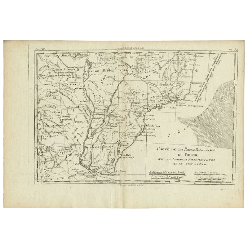
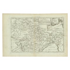
- Antique Map of Southern Brazil and Uruguay by Bonne, c.1780Located in Langweer, NL"Antique map titled 'Carte de la Partie Meridional du Bresil avec les Possessions Espagnoles Voisines Qui en Sont a l'Ouest.' Map of southern Brazil and present-day Uruguay from Port...Category
Antique 18th Century Maps
MaterialsPaper
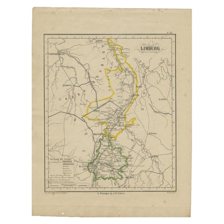
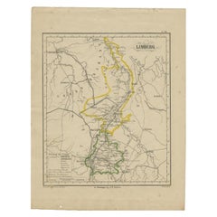
- Antique Map of Limburg, The Southern Most Province in The Netherlands, c.1870Located in Langweer, NLAntique map titled 'Limburg'. Map of the province of Limburg, the Netherlands. This map originates from 'F. C. Brugsma's Atlas van het Koninkrijk der Nederlanden (..)'. Artists and E...Category
Antique 19th Century Maps
MaterialsPaper
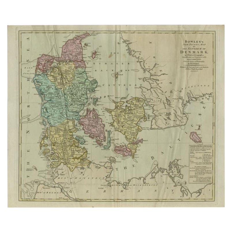
- Large Antique Map of Denmark by Bowles, c.1780By ThomasLocated in Langweer, NLAntique map titled 'Bowles's new pocket map of the Kingdom of Denmark (..)' Large map of Denmark. Source unknown, to be determined. Artists and Engravers: Made by 'Thomas & Carington Bowles' after 'J. Palairet'. Thomas Bowles, born around 1712, was map publisher and seller in London...Category
Antique 18th Century Maps
MaterialsPaper

You May Also Like
- Original Antique Map of Italy. C.1780Located in St Annes, LancashireGreat map of Italy Copper-plate engraving Published C.1780 Unframed.Category
Antique Early 1800s English Georgian Maps
MaterialsPaper

- Original Antique Map of Asia. C.1780Located in St Annes, LancashireGreat map of Asia Copper-plate engraving Published C.1780 Two small worm holes to right side of map Unframed.Category
Antique Early 1800s English Georgian Maps
MaterialsPaper

- Original Antique Map of India. C.1780Located in St Annes, LancashireGreat map of India Copper-plate engraving Published C.1780 Three small worm holes to right side of map and one bottom left corner Unframed.Category
Antique Early 1800s English Georgian Maps
MaterialsPaper

- Original Antique Map of South America. C.1780Located in St Annes, LancashireGreat map of South America Copper-plate engraving Published C.1780 Two small worm holes to left side of map Unframed.Category
Antique Early 1800s English Georgian Maps
MaterialsPaper
- Original Antique Map of The Netherlands, Sherwood, Neely & Jones, Dated 1809Located in St Annes, LancashireGreat map of The Netherlands Copper-plate engraving by Cooper Published by Sherwood, Neely & Jones. Dated 1809 Unframed.Category
Antique Early 1800s English Maps
MaterialsPaper
- Super Rare Antique French Map of Chine and the Chinese Empire, 1780Located in Amsterdam, Noord HollandSuper Rare Antique French Map of Chine and the Chinese Empire, 1780 Very nice map of Asia. 1780 Made by Bonne. Additional information: Type: Map ...Category
Antique 18th Century European Maps
MaterialsPaper


Recently Viewed
View AllMore Ways To Browse
Southern New And Used Furniture
Antique Carvers
16th Century English Antique
Presentation Bowl
19th C Country Antiques
Netherlands Sellers
18th Century English Bowl
French Catholic
Spanish Netherlands
French Country Bowl
Pocket Map
Antique Map Of Austria
18th Century English Carver
English 18th C Bowl
Captain Cook
Norwegian Antiques
Map Of Mexico
Antique Furniture South Australia