Items Similar to Antique Map of Sumatra by Tardieu, 1811


Want more images or videos?
Request additional images or videos from the seller
1 of 5
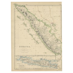
Antique Map of Sumatra by Tardieu, 1811
About the Item
Antique map Sumatra titled 'Partie de l'Isle Sumatra'. Part of the Island of Sumatra, where the English settlement of the Bay of Sellabar near Bencoute can be found. Originates from 'Voyage aux Indes Orientales, pendant les annees'. Artists and Engravers: Engraved by Tardieu. Published by A. Bertrand, Paris.
Artist: Engraved by Tardieu. Published by A. Bertrand, Paris.
Condition: Good, general age-related toning. Some tears along the folding lines, please study image carefully.
Date: 1811
Overall size: 40.5 x 53 cm.
Image size: 0.001 x 38 x 43 cm.
Antique prints have long been appreciated for both their aesthetic and investment value. They were the product of engraved, etched or lithographed plates. These plates were handmade out of wood or metal, which required an incredible level of skill, patience and craftsmanship. Whether you have a house with Victorian furniture or more contemporary decor an old engraving can enhance your living space. We offer a wide range of authentic antique prints for any budget.
- Dimensions:Height: 20.87 in (53 cm)Width: 15.95 in (40.5 cm)Depth: 0 in (0.01 mm)
- Materials and Techniques:
- Period:
- Date of Manufacture:1811
- Condition:
- Seller Location:Langweer, NL
- Reference Number:
About the Seller
5.0
Platinum Seller
These expertly vetted sellers are 1stDibs' most experienced sellers and are rated highest by our customers.
Established in 2009
1stDibs seller since 2017
1,948 sales on 1stDibs
Typical response time: <1 hour
- ShippingRetrieving quote...Ships From: Langweer, Netherlands
- Return PolicyA return for this item may be initiated within 14 days of delivery.
More From This SellerView All
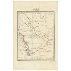
- Antique Map of Arabia by Tardieu '1843'Located in Langweer, NLAntique map titled 'Arabie'. Attractive small map of Arabia. This map originates from 'Dictionnaire Universel de Geographie Moderne' 4th Edition, by A.Pe...Category
Antique Mid-19th Century Maps
MaterialsPaper
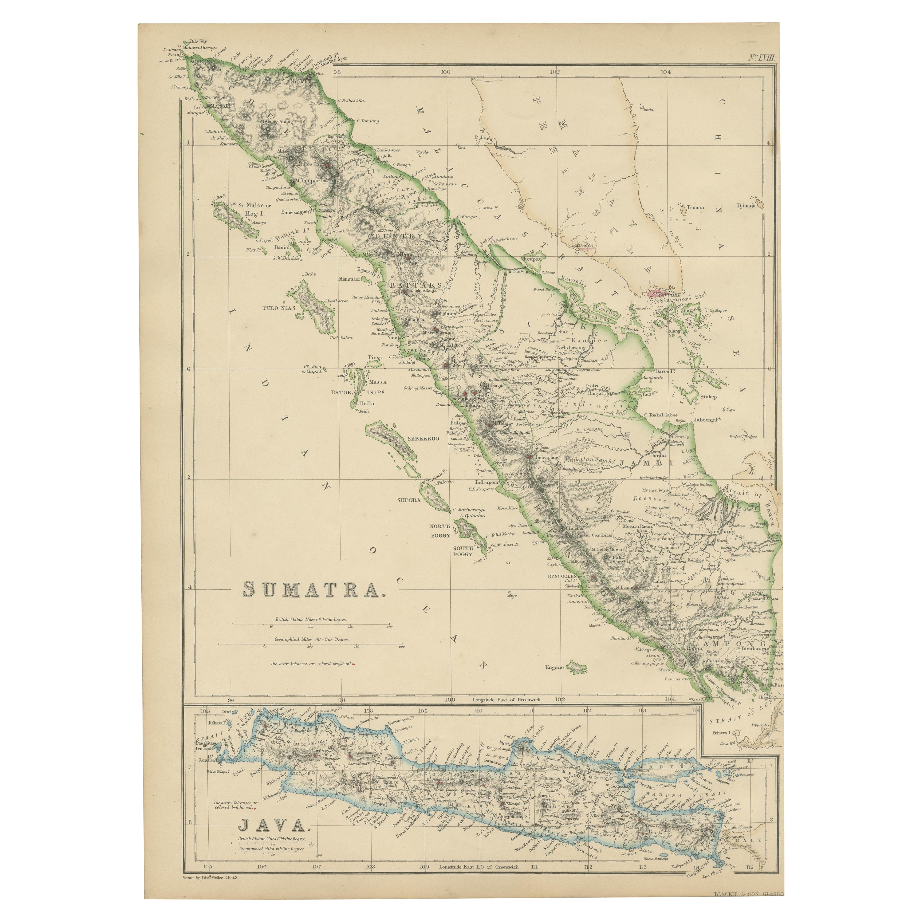
- Antique Map of Sumatra by W. G. Blackie, 1859Located in Langweer, NLAntique map titled 'Sumatra'. Original antique map of Sumatra with inset map of Java. This map originates from ‘The Imperial Atlas of Modern Geography’. Published by W. G. Blackie, 1...Category
Antique Mid-19th Century Maps
MaterialsPaper
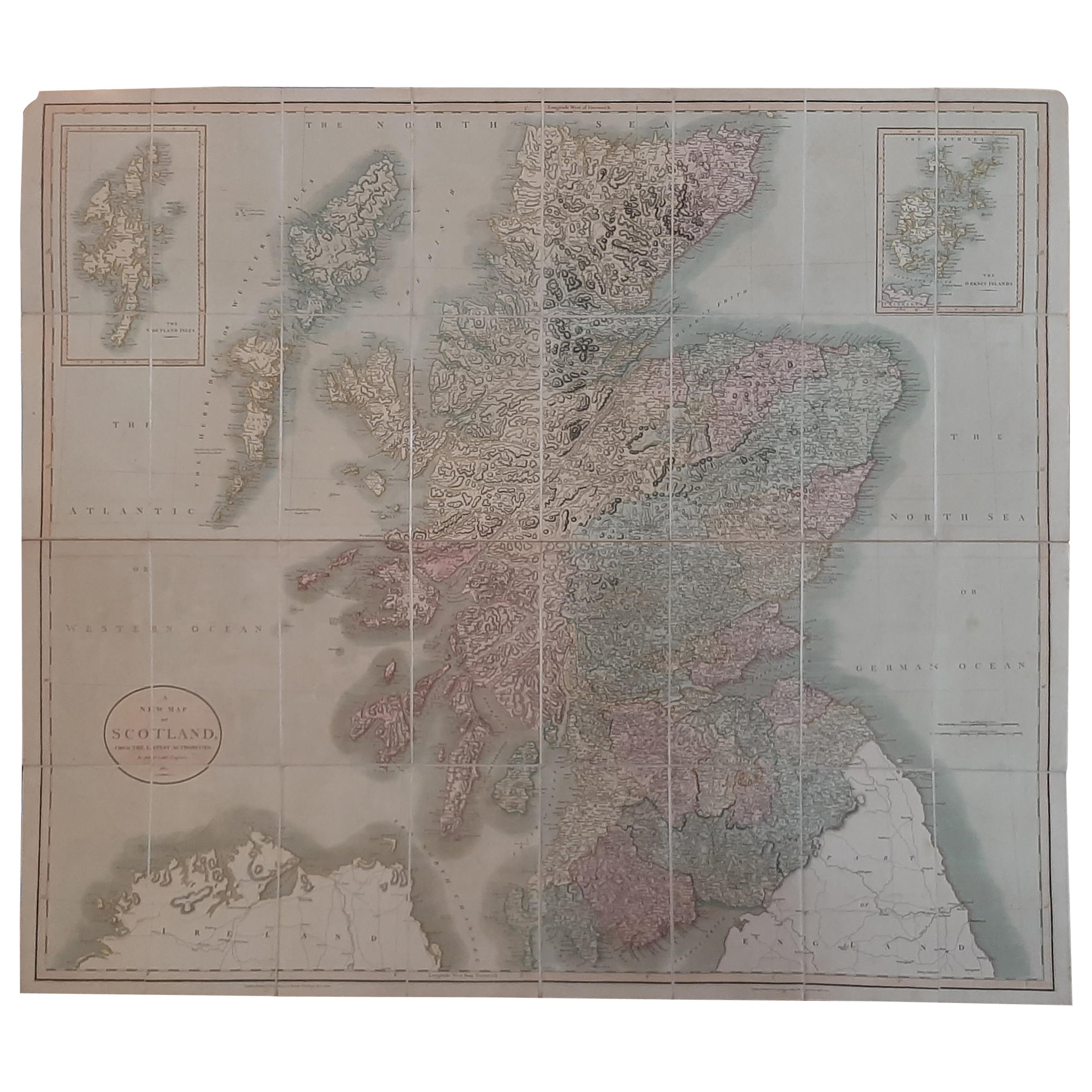
- Antique Map of Scotland by Cary, '1811'Located in Langweer, NLAntique map titled 'A New Map of Scotland from the Latest Authorities': **Title**: A New Map of Scotland from the Latest Authorities **Publisher**: J....Category
Antique Early 19th Century Maps
MaterialsLinen, Paper
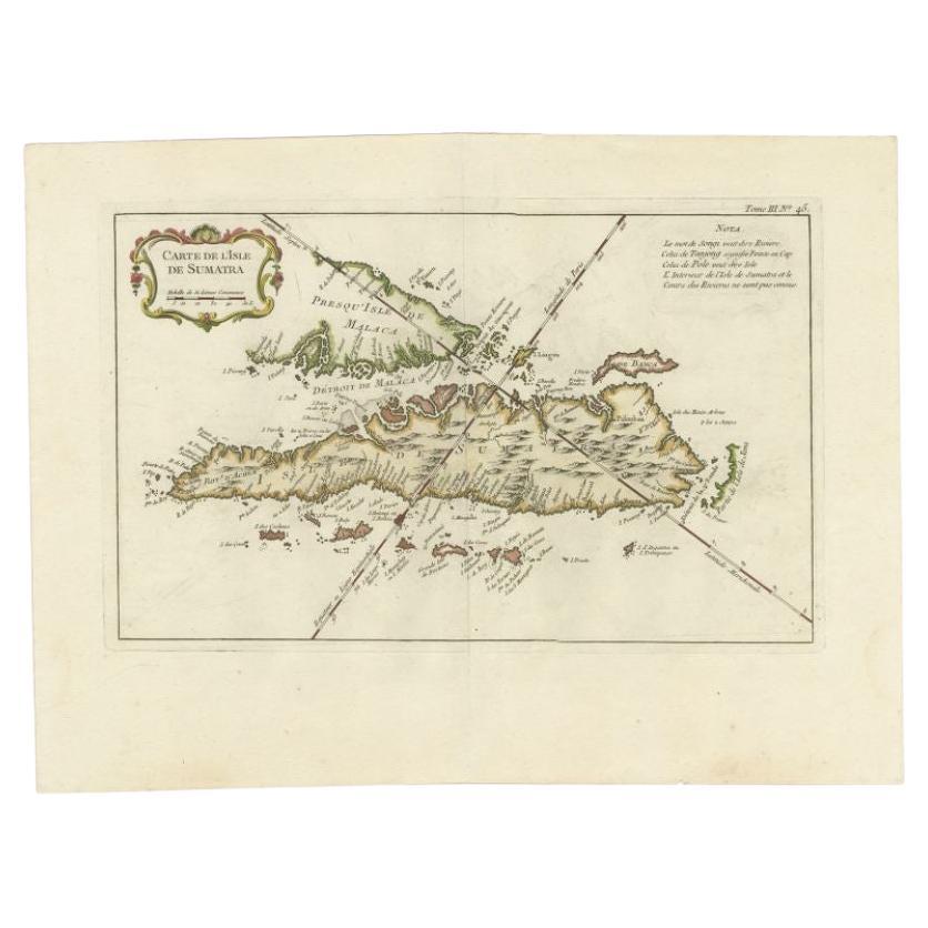
- Antique Map of Sumatra by Bellin, 1764Located in Langweer, NLAntique map Sumatra titled 'Carte de l'Isle de Sumatra'. Old map of Sumatra, Malaysia and the Straits of Malacca, including Singapore. This map originates ...Category
Antique 18th Century Maps
MaterialsPaper
- Antique Map of Sumatra, Indonesia 'c.1780'Located in Langweer, NLAntique map titled 'Neue Karte von der Insel Sumatra'. Extremely rare map of Sumatra, Indonesia. Published circa 1780.Category
Antique Late 18th Century Maps
MaterialsPaper
- Antique Map of China and Japan by Tardieu, 1821Located in Langweer, NLAntique map titled 'Carte de la Chine et du Japon'. Detailed map of China, showing Korea, Japan and Taiwan. This map originates from 'L'histoire général des voyages' by J.F. de la Harpe.Category
Antique Early 19th Century Maps
MaterialsPaper


You May Also Like
- 1812 United States Map, by Pierre Tardieu, Antique French Map Depicting the U.S.By Pierre François TardieuLocated in Colorado Springs, CO1812 "United States of Nth America -- Carte des Etats-Unis De L'Amerique Septentrionale" Two-Sheet Map by Tardieu This attractive map, published in Paris in 1812, is one of the most rare large format maps from the period. It features a view of the East Coast of the U.S. from Maryland to just below South Carolina. Additionally, Ellicott’s plan for the City of Washington D.C. is included at the top right and an illustration of Niagara Falls is shown at the bottom right with a description in both French and English. This extremely detailed map not only depicts the mountainous regions of the southeastern U.S., but also includes names of regions, rivers, and towns. Based on the first state of Arrowsmith’s 4-sheet map of the United States, this map is completely engraved by Tardieu in Paris and showcases high quality engravings. This detailed map of the recently independent United States includes one of the largest and earliest examples of the Ellicott plan of Washington DC. The artist, Pierre François Tardieu (PF Tardieu) was a very well-known map engraver, geographer, and illustrator. Awarded a bronze medal by King Louis-Phillipe for the accuracy and beauty of his map-making, Tardieu produced many fine works including maps of Louisiana...Category
Antique 1810s French Maps
MaterialsPaper
- Antique Paterson's Guide to Britain, English, Maps, Georgian, Published 1811Located in Hele, Devon, GBThis is an antique copy of Paterson's New and Accurate guide to Direct & Principal Crossroads. An English, bound book of maps and descriptive tables, published in English by Longman,...Category
Antique Early 19th Century British Georgian Books
MaterialsPaper
- 1861 Topographical Map of the District of Columbia, by Boschke, Antique MapLocated in Colorado Springs, COPresented is an original map of Albert Boschke's extremely sought-after "Topographical Map of the District of Columbia Surveyed in the Years 1856 ...Category
Antique 1860s American Historical Memorabilia
MaterialsPaper
- 1907 Map of Colorado, Antique Topographical Map, by Louis NellLocated in Colorado Springs, COThis highly detailed pocket map is a topographical map of the state of Colorado by Louis Nell from 1907. The map "has been complied from all availabl...Category
Antique Early 1900s American Maps
MaterialsPaper
- Antique Map of Italy by Andriveau-Goujon, 1843By Andriveau-GoujonLocated in New York, NYAntique Map of Italy by Andriveau-Goujon, 1843. Map of Italy in two parts by Andriveau-Goujon for the Library of Prince Carini at Palazzo Carini i...Category
Antique 1840s French Maps
MaterialsLinen, Paper
- Antique Map of Principality of MonacoBy Antonio Vallardi EditoreLocated in Alessandria, PiemonteST/619 - "Old Geographical Atlas of Italy - Topographic map of ex-Principality of Monaco" - ediz Vallardi - Milano - A somewhat special edition ---Category
Antique Late 19th Century Italian Other Prints
MaterialsPaper


Recently Viewed
View AllMore Ways To Browse
Antique Bay
Oriental Antiques Collectables
Antique Oriental Plate
Antique Oriental Plates
Oriental 19th Century Plate
Antique Paris Map Print
Antique Oriental Print
Antique Maps Of Long Island
Antique Map Of Long Island
Antique Map Long Island
Antique Long Island Map
Sumatra Pendant
Antique 16th Century Plates
Antique Caribbean Furniture
17th Century Plate Set
Antique Rose Compass
Israeli Antique
Antique Map Paint