Items Similar to Antique Map of the Swabia Region of Germany by Cary, '1811'


Want more images or videos?
Request additional images or videos from the seller
1 of 5
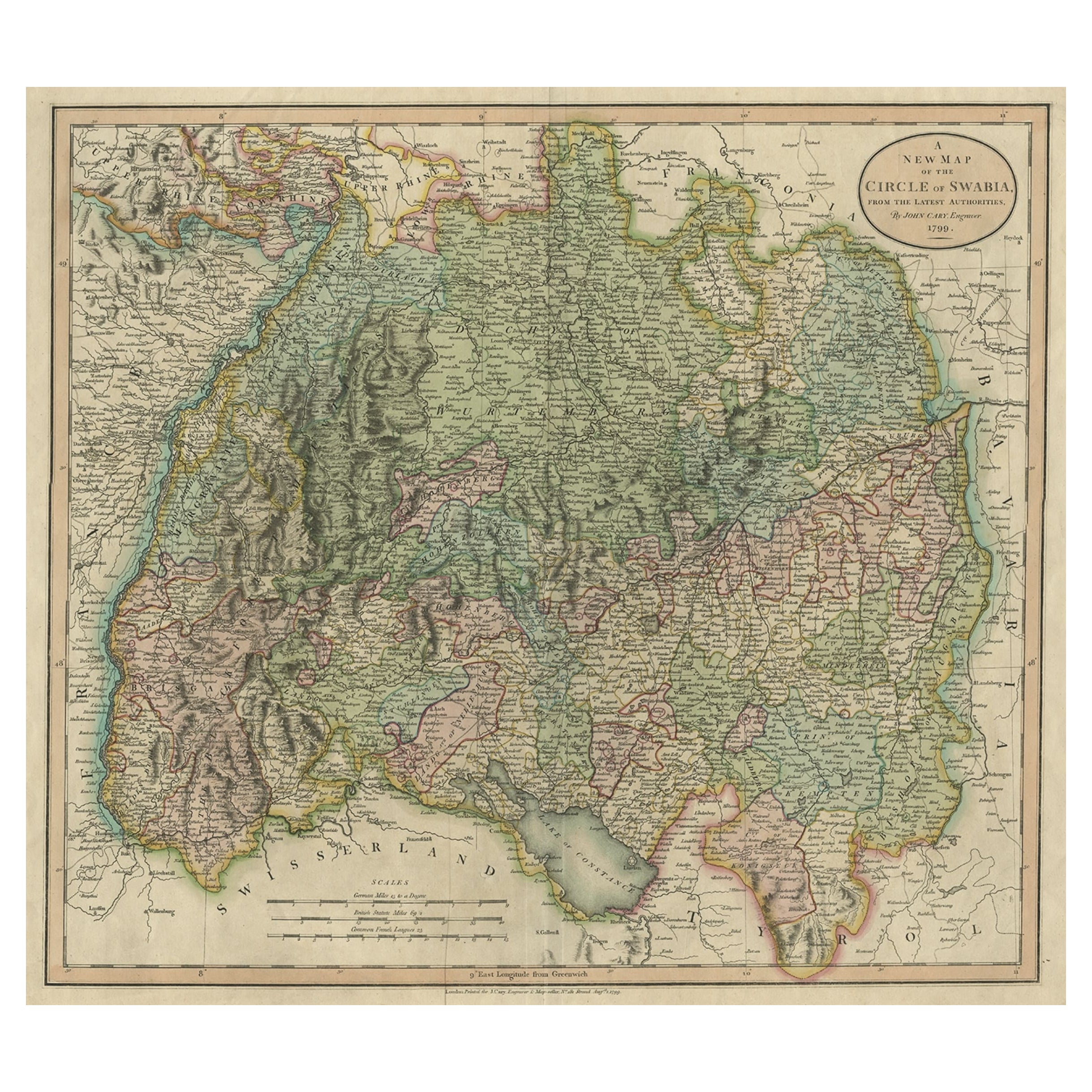
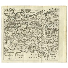
Antique Map of the Swabia Region of Germany by Cary, '1811'
About the Item
Antique map titled 'A New Map of the Circle of Swabia'. Antique map of Swabia in Southwestern Germany. Covers from the Upper Rhine region south as far as Switzerland, Lake Constance and Tyrol. Extends eastward as far as Bavaria and westward as far as France. Includes the Black Forest region and the Duchy of Wurtenburg (Stuttgard).
- Creator:John Cary (Artist)
- Dimensions:Height: 21.46 in (54.5 cm)Width: 24.81 in (63 cm)Depth: 0.02 in (0.5 mm)
- Materials and Techniques:
- Period:
- Date of Manufacture:1811
- Condition:General age-related toning. Original coloring, please study images carefully.
- Seller Location:Langweer, NL
- Reference Number:

John Cary
John Cary was an English cartographer. He was born in February of 1755 and died in August of 1835. His career started with his apprenticeship in London, and he opened up his own shop in the Strand in 1783. His atlas New and Correct English Atlas became the standard reference work in England. He was commissioned in 1794 by the Postmaster General to survey England's roads. Out of this commission, he published Cary's New Itinerary in 1798. He later produced Ordnance Survey maps before 1805. His business was eventually taken over by G.F. Cruchley.
About the Seller
5.0
Platinum Seller
These expertly vetted sellers are 1stDibs' most experienced sellers and are rated highest by our customers.
Established in 2009
1stDibs seller since 2017
1,957 sales on 1stDibs
Typical response time: <1 hour
- ShippingRetrieving quote...Ships From: Langweer, Netherlands
- Return PolicyA return for this item may be initiated within 14 days of delivery.
More From This SellerView All
- Antique Map of Franconia, a region of Germany, '1811'By John CaryLocated in Langweer, NLAntique map titled 'A New Map of the Circle of Franconia'. Detailed map of Franconia in Northwestern Germany. Covers from Upper Saxony south to Swabia, west to the Lower Rhine and we...Category
Antique Early 19th Century Maps
MaterialsPaper
- Antique Map of the Upper and Lower Rhine by Cary '1811'By John CaryLocated in Langweer, NLAntique map titled 'A New Map of the Circles of the Upper and Lower Rhine'. Antique map covering an area from Westphalia and Lower Saxony in the north to France and Swabia in the south.Category
Antique Early 19th Century Maps
MaterialsPaper
- Antique Map of Bavaria and Salzburg by Cary, 1811By John CaryLocated in Langweer, NLAntique map titled 'A New Map of the Circle of Bavaria'. Antique map of Bavaria and Salzburg, Germany. Covers the Duchy of Bavaria and the mountainous A...Category
Antique Early 19th Century Maps
MaterialsPaper
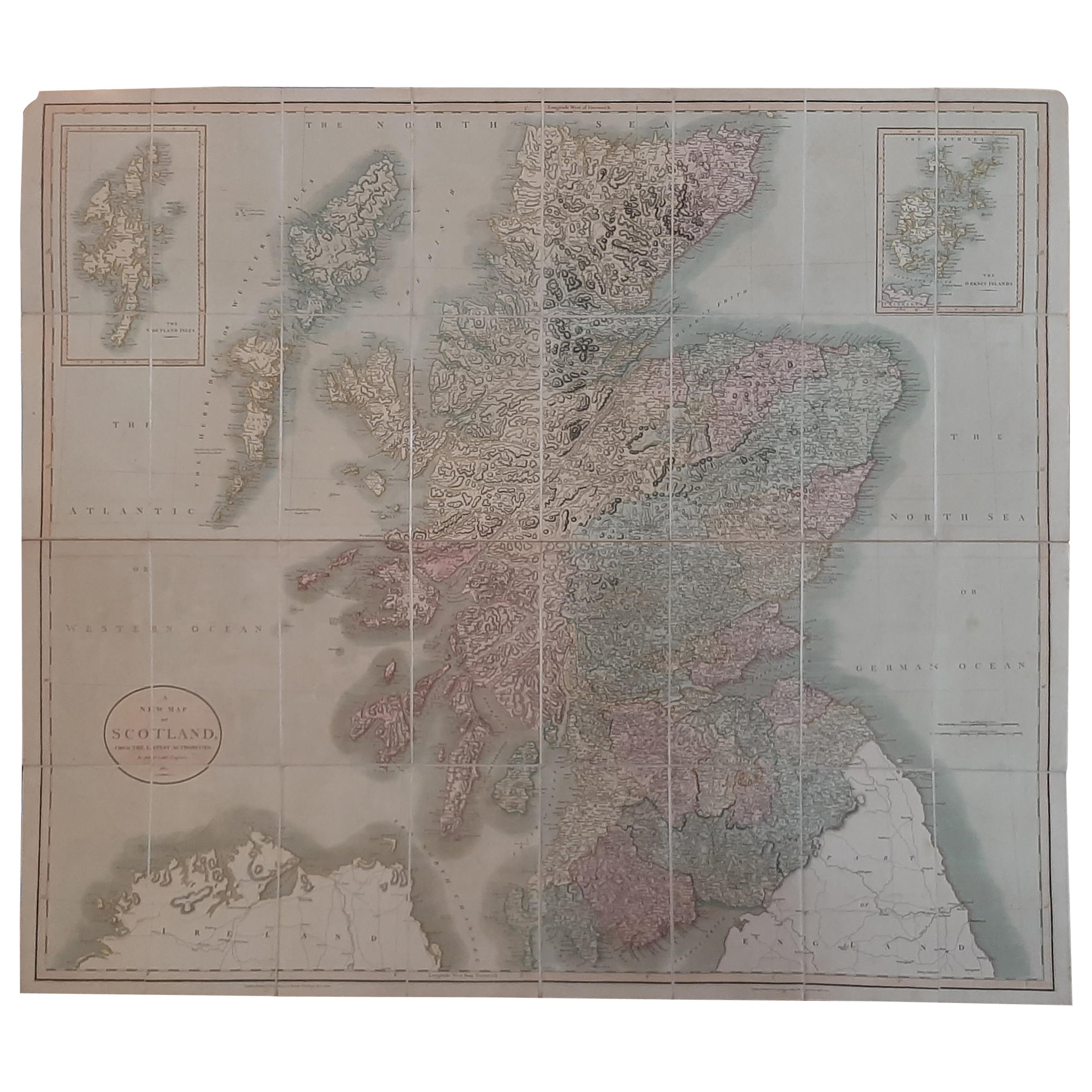
- Antique Map of Scotland by Cary, '1811'Located in Langweer, NLAntique map titled 'A New Map of Scotland from the Latest Authorities': **Title**: A New Map of Scotland from the Latest Authorities **Publisher**: J....Category
Antique Early 19th Century Maps
MaterialsLinen, Paper
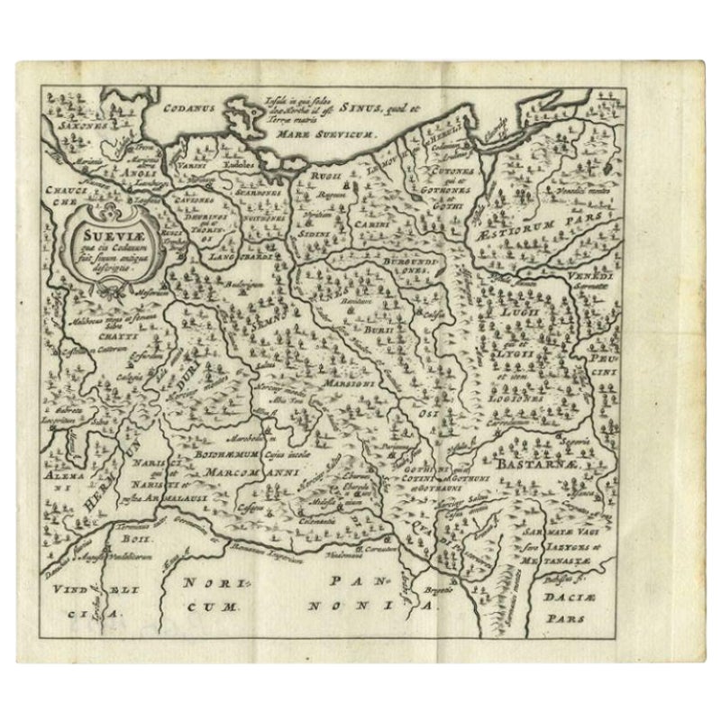
- Attractive Original Hand-Colored Map of the Swabia Region of Germany, 1799Located in Langweer, NLAntique map titled 'A New Map of the Circle of Swabia, from the Latest Authorities'. Attractive example of John Cary's 1799 map of the Swabia region of Germany. Covers from the U...Category
Antique 1790s Maps
MaterialsPaper
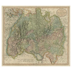
- Antique Map of Swabia, 1685Located in Langweer, NLAntique map titled 'Sueviae quae cis Codanum fuit finum Antiqua defcriptio.' Miniature map of Swabia, a medieval Duchy in south-west Germany, that also included part of Poland, from ...Category
Antique 17th Century Maps
MaterialsPaper


You May Also Like
- 17th Century Hand-Colored Map of a Region in West Germany by JanssoniusBy Johannes JanssoniusLocated in Alamo, CAThis attractive highly detailed 17th century original hand-colored map is entitled "Archiepiscopatus Maghdeburgensis et Anhaltinus Ducatus cum terris adjacentibus". It was published ...Category
Antique Mid-17th Century Dutch Maps
MaterialsPaper
- 17th Century Hand Colored Map of the Liege Region in Belgium by VisscherBy Nicolaes Visscher IILocated in Alamo, CAAn original 17th century map entitled "Leodiensis Episcopatus in omnes Subjacentes Provincias distincté divisusVisscher, Leodiensis Episcopatus" by Nicolaes Visscher II, published in Amsterdam in 1688. The map is centered on Liege, Belgium, includes the area between Antwerp, Turnhout, Roermond, Cologne, Trier and Dinant. This attractive map is presented in a cream-colored mat measuring 30" wide x 27.5" high. There is a central fold, as issued. There is minimal spotting in the upper margin and a tiny spot in the right lower margin, which are under the mat. The map is otherwise in excellent condition. The Visscher family were one of the great cartographic families of the 17th century. Begun by Claes Jansz Visscher...Category
Antique Late 17th Century Dutch Maps
MaterialsPaper
- The Normandy Region of France: A 17th C. Hand-colored Map by Sanson and JaillotBy Nicolas SansonLocated in Alamo, CAThis large hand-colored map entitled "Le Duché et Gouvernement de Normandie divisée en Haute et Basse Normandie en divers Pays; et par evêchez, avec le Gouvernement General du Havre ...Category
Antique 1690s French Maps
MaterialsPaper
- Original Antique Map of The World by Thomas Clerk, 1817Located in St Annes, LancashireGreat map of The Eastern and Western Hemispheres On 2 sheets Copper-plate engraving Drawn and engraved by Thomas Clerk, Edinburgh. Published by Mackenzie And Dent, 1817 ...Category
Antique 1810s English Maps
MaterialsPaper
- Extremely Rare Copy of the Venezuelan Declaration of Independance, 1811Located in Amsterdam, NLExtremely rare copy of the Venezuelan Declaration of Independance 'Declaracion de Independencia de las Siete Provincias Unidas de Venezuela en Congreso de 5 de Julio de 1811' By Lorenzo Lüthy (c. 1811-1877), printed in Philadelphia, Peter S. Duval, 1841. Lithograph on laid paper, mounted in passepartout, H. 84 x W. 64.5 cm (with mount H. 96,5 x W. 77 cm.) Large and extremely rare lithographed broadside Declaration of Independence of Venezuela by American immigrant...Category
Antique Early 19th Century Venezuelan Prints
MaterialsPaper
- Original Antique Map of The Netherlands, Engraved by Barlow, Dated 1807Located in St Annes, LancashireGreat map of Netherlands Copper-plate engraving by Barlow Published by Brightly & Kinnersly, Bungay, Suffolk. Dated 1807 Unframed.Category
Antique Early 1800s English Maps
MaterialsPaper


Recently Viewed
View AllMore Ways To Browse
Germany Map
Map Of Germany
19th Century German Collectibles
Antique German Map
Antique German Maps
Antique Map Germany
Antique Maps Germany
Antique Map Of Germany
Antique Maps Of Germany
Black Constance
Map Of South Of France
Antique Southwestern Furniture
Swiss Antiques And Collectables
Southwestern Antiques
Antique Bavaria
Antique Map Switzerland
Antique Map Of Switzerland
Map Bavaria