Items Similar to Antique Map of Bavaria and Salzburg by Cary, 1811


Want more images or videos?
Request additional images or videos from the seller
Antique Map of Bavaria and Salzburg by Cary, 1811
About the Item
Antique map titled 'A New Map of the Circle of Bavaria'. Antique map of Bavaria and Salzburg, Germany. Covers the Duchy of Bavaria and the mountainous Archbishopric of Salzburg as well as parts of Franconia, Swabia, Tyrol, Bohemia and Austria.
- Creator:John Cary (Artist)
- Dimensions:Height: 21.46 in (54.5 cm)Width: 24.81 in (63 cm)Depth: 0.02 in (0.5 mm)
- Materials and Techniques:
- Period:
- Date of Manufacture:1811
- Condition:General age-related toning. Original coloring, please study images carefully.
- Seller Location:Langweer, NL
- Reference Number:

John Cary
John Cary was an English cartographer. He was born in February of 1755 and died in August of 1835. His career started with his apprenticeship in London, and he opened up his own shop in the Strand in 1783. His atlas New and Correct English Atlas became the standard reference work in England. He was commissioned in 1794 by the Postmaster General to survey England's roads. Out of this commission, he published Cary's New Itinerary in 1798. He later produced Ordnance Survey maps before 1805. His business was eventually taken over by G.F. Cruchley.
About the Seller
5.0
Platinum Seller
These expertly vetted sellers are 1stDibs' most experienced sellers and are rated highest by our customers.
Established in 2009
1stDibs seller since 2017
1,956 sales on 1stDibs
Typical response time: <1 hour
- ShippingRetrieving quote...Ships From: Langweer, Netherlands
- Return PolicyA return for this item may be initiated within 14 days of delivery.
More From This SellerView All
- Antique Map of the Upper and Lower Rhine by Cary '1811'By John CaryLocated in Langweer, NLAntique map titled 'A New Map of the Circles of the Upper and Lower Rhine'. Antique map covering an area from Westphalia and Lower Saxony in the north to France and Swabia in the south.Category
Antique Early 19th Century Maps
MaterialsPaper
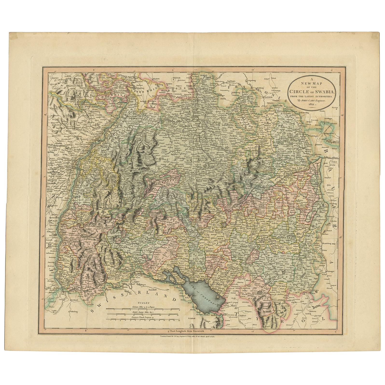
- Antique Map of the Swabia Region of Germany by Cary, '1811'By John CaryLocated in Langweer, NLAntique map titled 'A New Map of the Circle of Swabia'. Antique map of Swabia in Southwestern Germany. Covers from the Upper Rhine region south as far as Switzerland, Lake Constance ...Category
Antique Early 19th Century Maps
MaterialsPaper
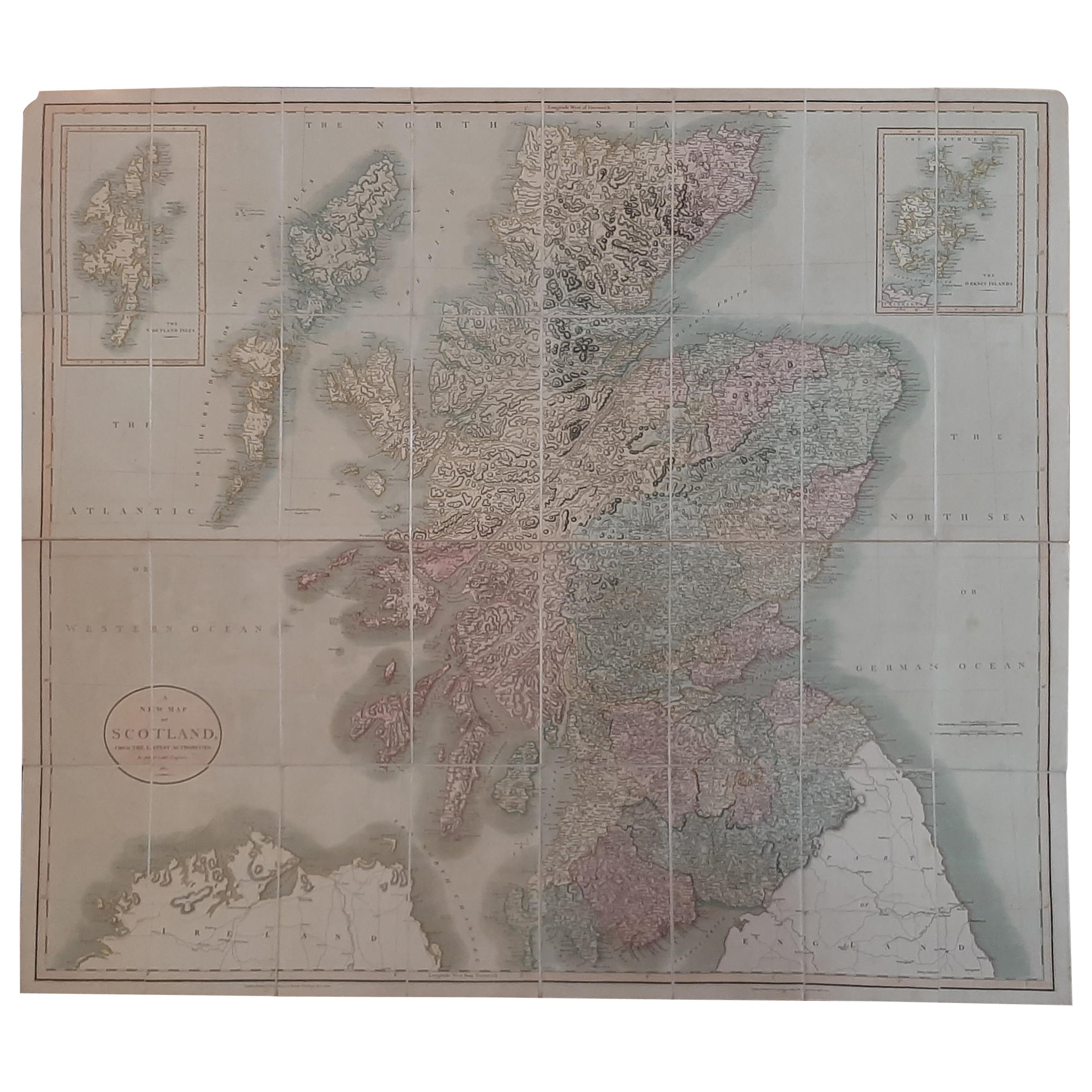
- Antique Map of Scotland by Cary, '1811'Located in Langweer, NLAntique map titled 'A New Map of Scotland from the Latest Authorities': **Title**: A New Map of Scotland from the Latest Authorities **Publisher**: J....Category
Antique Early 19th Century Maps
MaterialsLinen, Paper
- Antique Map of Franconia, a region of Germany, '1811'By John CaryLocated in Langweer, NLAntique map titled 'A New Map of the Circle of Franconia'. Detailed map of Franconia in Northwestern Germany. Covers from Upper Saxony south to Swabia, west to the Lower Rhine and we...Category
Antique Early 19th Century Maps
MaterialsPaper
- Antique Map of the Region of Salzburg by Ortelius 'circa 1606'Located in Langweer, NLAntique map titled 'Salisburgensis Iurisdictionis'. Original antique map of the region of Salzburg, Austria. Published by A. Ortelius, circa 1606.Category
Antique Early 17th Century Maps
MaterialsPaper
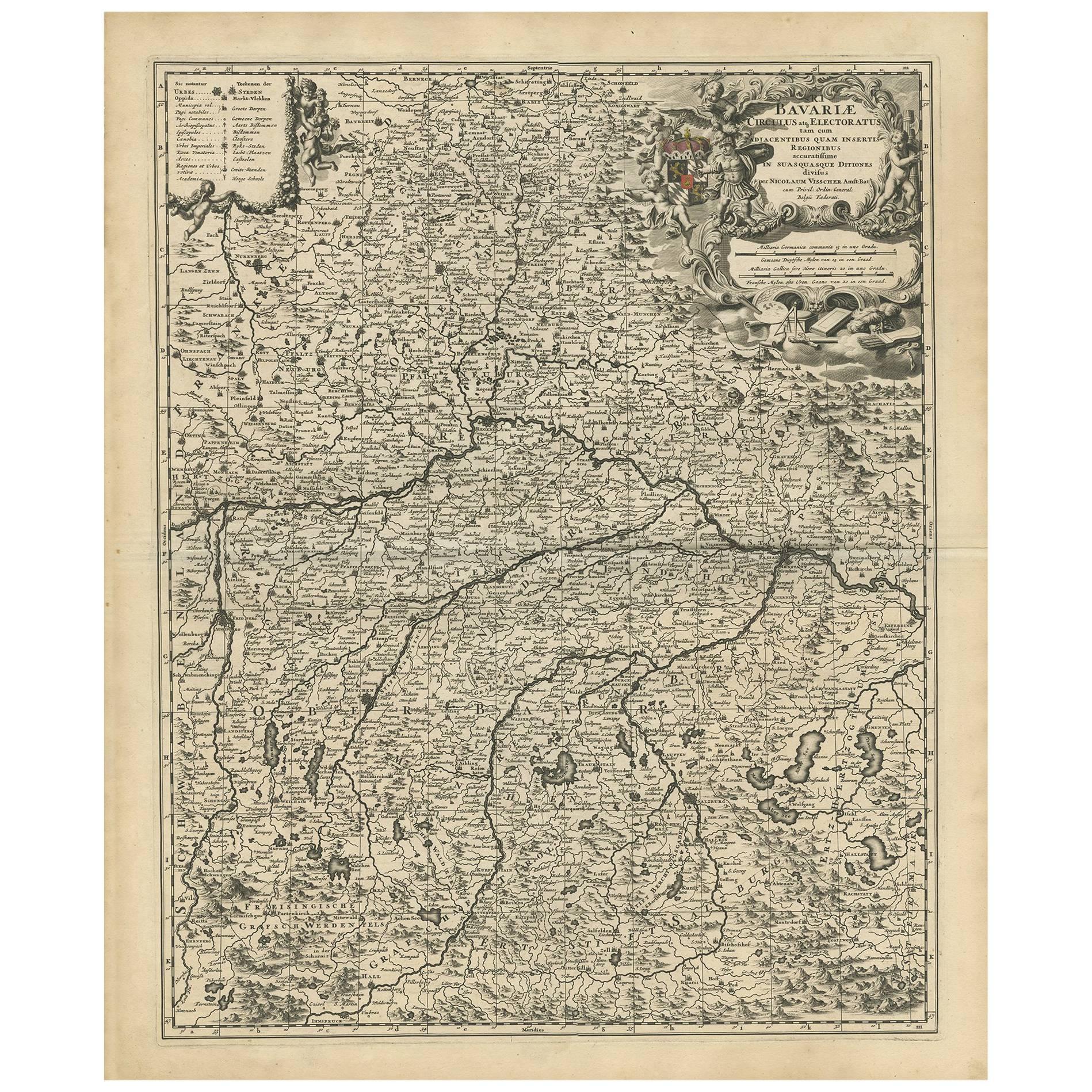
- Antique Map of Bavaria with many details, GermanyLocated in Langweer, NLAntique map titled 'Bavariae Circulus atq Electoratus tam cum Adiacentibus quam insertis Regionibus (..)'. Dutch map of Bavaria, showing the many cities, towns, and other features of...Category
Antique Late 17th Century Maps
MaterialsPaper


You May Also Like
- Antique Map of Italy by Andriveau-Goujon, 1843By Andriveau-GoujonLocated in New York, NYAntique Map of Italy by Andriveau-Goujon, 1843. Map of Italy in two parts by Andriveau-Goujon for the Library of Prince Carini at Palazzo Carini i...Category
Antique 1840s French Maps
MaterialsLinen, Paper
- Antique Map of Principality of MonacoBy Antonio Vallardi EditoreLocated in Alessandria, PiemonteST/619 - "Old Geographical Atlas of Italy - Topographic map of ex-Principality of Monaco" - ediz Vallardi - Milano - A somewhat special edition ---Category
Antique Late 19th Century Italian Other Prints
MaterialsPaper
- Original Antique Map of Spain and Portugal by Thomas Clerk, 1817Located in St Annes, LancashireGreat map of Spain and Portugal Copper-plate engraving Drawn and engraved by Thomas Clerk, Edinburgh. Published by Mackenzie And Dent, 1817 Unframed.Category
Antique 1810s English Maps
MaterialsPaper
- Original Antique Map of Spain and Portugal, Engraved By Barlow, 1806Located in St Annes, LancashireGreat map of Spain And Portugal Copper-plate engraving by Barlow Published by Brightly & Kinnersly, Bungay, Suffolk. 1806 Unframed.Category
Antique Early 1800s English Maps
MaterialsPaper
- Original Antique Map of Russia By Arrowsmith. 1820Located in St Annes, LancashireGreat map of Russia Drawn under the direction of Arrowsmith Copper-plate engraving Published by Longman, Hurst, Rees, Orme and Brown, 1820 Unframed.Category
Antique 1820s English Maps
MaterialsPaper
- Original Antique Map of Spain and Portugal, circa 1790Located in St Annes, LancashireSuper map of Spain and Portugal Copper plate engraving by A. Bell Published, circa 1790. Unframed.Category
Antique 1790s English Other Maps
MaterialsPaper


Recently Viewed
View AllMore Ways To Browse
Bavaria Antique
Austrian And German Antique Furniture
Map Austria
Map Of Austria
Antique Bavaria
Antique Map Of Austria
Map Bavaria
Map Of Bavaria
Bohemia Map
Old Map
Antique Map Of World
Map Of World Antique
Antique Map Of The World
Antique Maps Of The World
Map Of The World Antique
Rare Maps
Collectible Fair
Used World Atlas