Items Similar to Antique Map of The United States and Canada by A & C. Black, 1870


Want more images or videos?
Request additional images or videos from the seller
1 of 6
Antique Map of The United States and Canada by A & C. Black, 1870
About the Item
Antique map titled 'United States North Eastern Section and Canada'. Original antique map of Map of The United States North Eastern Section and Canada. This map originates from ‘Black's General Atlas of The World’. Published by A & C. Black, 1870.
- Dimensions:Height: 17.52 in (44.5 cm)Width: 23.63 in (60 cm)Depth: 0.02 in (0.5 mm)
- Materials and Techniques:
- Period:
- Date of Manufacture:1870
- Condition:Wear consistent with age and use. General age-related toning. some foxing, Please study image carefully.
- Seller Location:Langweer, NL
- Reference Number:
About the Seller
5.0
Platinum Seller
These expertly vetted sellers are 1stDibs' most experienced sellers and are rated highest by our customers.
Established in 2009
1stDibs seller since 2017
1,916 sales on 1stDibs
Typical response time: <1 hour
- ShippingRetrieving quote...Ships From: Langweer, Netherlands
- Return PolicyA return for this item may be initiated within 14 days of delivery.
More From This SellerView All
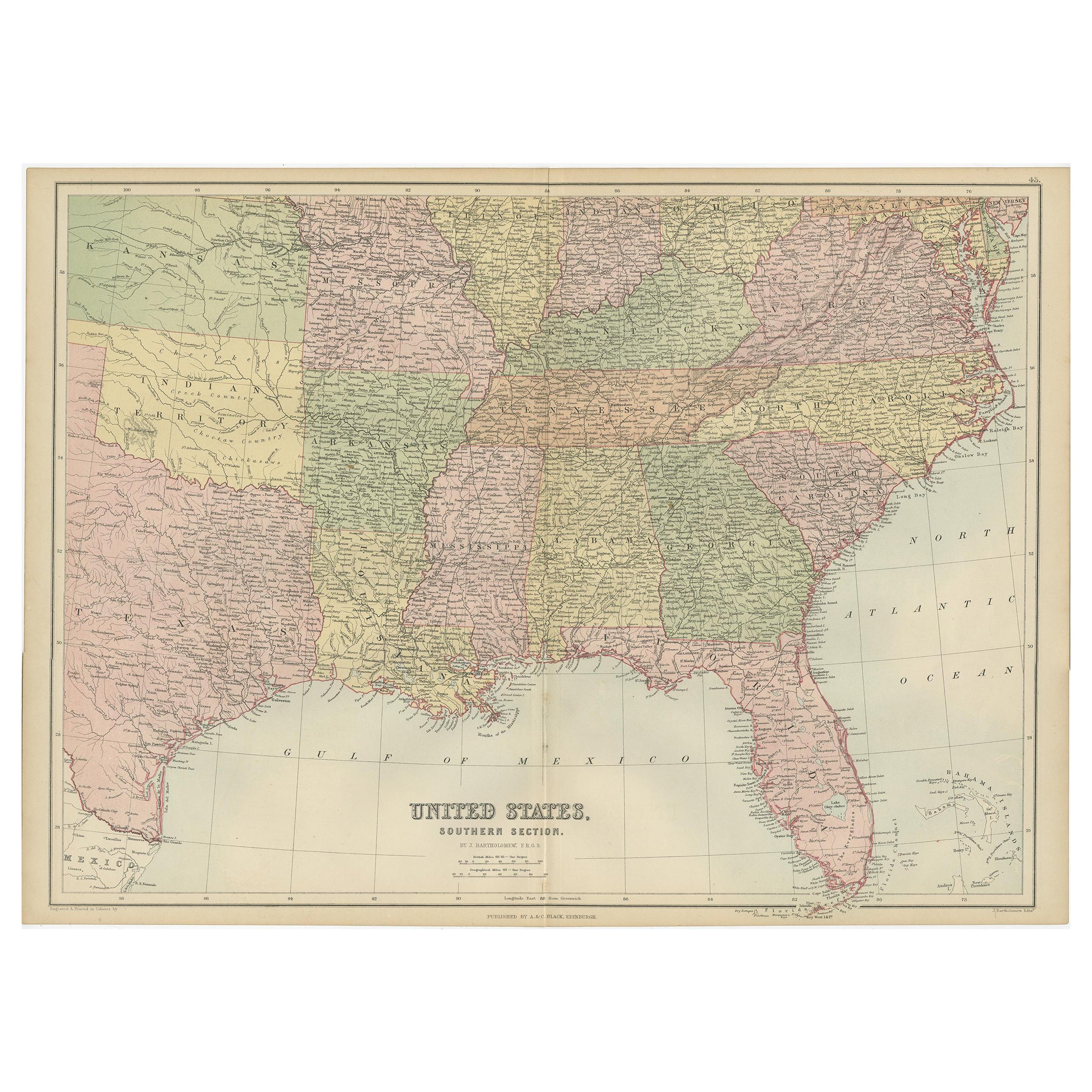
- Antique Map of The United States Southern Section by A & C. Black, 1870Located in Langweer, NLAntique map titled 'United States Southern Section'. Original antique map of Map of The United States Southern Section. This map originates from ‘Black's General Atlas of The World’....Category
Antique Late 19th Century Maps
MaterialsPaper
- Antique Map of the United States by Lowry, '1852'Located in Langweer, NLAntique map titled 'United States'. Four individual sheets of the United States. This map originates from 'Lowry's Table Atlas constructed and engraved from the most recent Authoriti...Category
Antique Mid-19th Century Maps
MaterialsPaper
- Antique Map of the United States by Balbi '1847'Located in Langweer, NLAntique map titled 'Etats-Unis'. Original antique map of the United States. This map originates from 'Abrégé de Géographie (..)' by Ad...Category
Antique Mid-19th Century Maps
MaterialsPaper
- Antique Map of the United States by Titus '1871'Located in Langweer, NLAntique map titled 'The United States of America'. Original antique map of the United States. This map originates from 'Atlas of Prebl...Category
Antique Late 19th Century Maps
MaterialsPaper
- Small Map of the United StatesLocated in Langweer, NLAntique map titled 'Amérique septe. Physique'. Small map of the United States. lithographed by C. Callewaert brothers in Brussels circa 1870.Category
Antique Mid-19th Century Maps
MaterialsPaper
- Antique Map of the Eastern United States by Levasseur '1875'Located in Langweer, NLAntique map titled 'Carte de la Region orientale des États-Unis et de la dominion du Canada'. Large map of the Eastern United States. This map originates from 'Atlas de Géographie Mo...Category
Antique Late 19th Century Maps
MaterialsPaper


You May Also Like
- Original Antique Map of United States, Grattan and Gilbert, 1843Located in St Annes, LancashireGreat map of United States Drawn and engraved by Archer Published by Grattan and Gilbert. 1843 Original colour Unframed.Category
Antique 1840s English Maps
MaterialsPaper
- Original Antique Map of Canada, Arrowsmith, 1820Located in St Annes, LancashireGreat map of Canada. Drawn under the direction of Arrowsmith. Copper-plate engraving. Published by Longman, Hurst, Rees, Orme and Brown, 1820 ...Category
Antique 1820s English Maps
MaterialsPaper
- 1863 "Lloyd's New Map of the United States, the Canadas, and New Brunswick"Located in Colorado Springs, COPresented is “Lloyd's New Map of the United States, the Canadas and New Brunswick, From the latest Surveys, Showing Every Railroad & Station Finished to June 1863, and the Atlantic and Gulf Coasts.” A large, Civil War-era hanging map of the United States and adjacent territories, this map covers the area from the Atlantic Ocean and extends as far west as the 103 meridian, to “Dacotah,” Nebraska, Kansas, "Indian Territory," and Texas. The southern continuation of Florida is shown in an inset map along the right margin. This map was published by J. T. Lloyd, in New York, in 1863. According to the publisher’s marking at lower right, this map was originally issued in two states: "in Sheets, Colored" for 50 cents, and "Varnished nicely, with Rollers" for $1. Throughout the map, the counties are colored and the towns and cities well labeled. A reference key in the bottom margin provides symbols for railroads, turnpikes and wagon roads, state capitals, cities and towns, and village post offices. As emphasized in the map’s title, this map is especially notable for the countless railway lines and stations depicted, with distances noted between points, listing “every railroad and finished station to June 1863.” Additionally, two shipping agents and their routes are drawn out of New York City. The map includes details of the steamship routes into New York and Philadelphia from Liverpool and on to California and Oregon via an overland Nicaraguan trek, presumably to assist gold rush emigrants. This expansive and impressive map depicts the eastern half of the United States in the third year of the Civil War. In order not to recognize the legitimacy of the Confederate States of America, each state is shown in the same manner as the Union states. The only indication that the American Civil War was in progress when this map was published is a printed notice that Gideon Wells, Secretary of the Navy, wishes to acquire a quote on 100 copies of Lloyd’s Mississippi River map...Category
Antique 1860s American Maps
MaterialsLinen, Wood, Paper
- N.E. View of the United States Capitol, Washington, DC Antique Proof Print 1858Located in Colorado Springs, COThis engraved print shows a view of the United States Capitol Building, in Washington, D.C. The print depicts the neoclassical building from the northeast orientation, with a bustling street scene in front. The steel engraving is a proof printing, drawn and engraved by Henry Sartain and published in 1858. Plans began in May 1854 to build a new cast-iron dome for the United States Capitol. The then-architect of the Capitol Thomas Walter and his team were sold on the aesthetics of a new dome, as well as the utility of a fire-proof one. A year later, on March 3, 1855, President Franklin Pierce...Category
Antique 1850s American Prints
MaterialsPaper
- 1859 "Map of the United States of America..." by J. H. ColtonBy J.H. ColtonLocated in Colorado Springs, COPresented is an 1859 “Map of the United States of America, the British Provinces, Mexico, the West Indies and Central America with Part of...Category
Antique 1850s American Maps
MaterialsPaper
- Original Antique Map of The United States of America, circa 1890Located in St Annes, LancashireGreat map of the USA By The Stanford's Geographical Establishment Original colour Unframed.Category
Antique 1890s English Victorian Maps
MaterialsPaper


Recently Viewed
View AllMore Ways To Browse
Antique Furniture United States
Antique United States
Antique Furniture Canada
Antique Canadian Furniture
Canadian Antique Furniture
Canadian Antique
Canada Antiques
19th Century Canadian Furniture
Antique United States Maps
Antique Map United States
Antique United States Map
United States Map Antique
Antique Maps Of United States
Antique Maps Of States
Antique Map Of The United States
Antique Maps Of The United States
Canadian Paper 19th
Maps Canada