Items Similar to Map of the West African coast from the North of Mauretania to Guinee, 1788

Want more images or videos?
Request additional images or videos from the seller
1 of 5
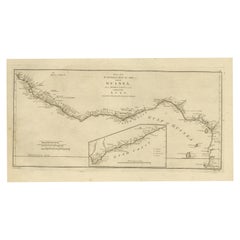
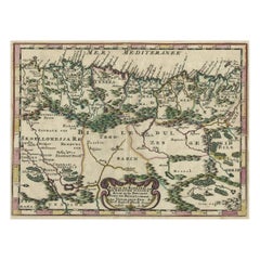
Map of the West African coast from the North of Mauretania to Guinee, 1788
About the Item
Antique map titled 'Particular Map of the Western Coast of Africa, from Cape Blanco to Cape de Verga, and of the Course of the Rivers Senega and Gambia.'
Map of the African coast from the north of Mauretania to Guinee. This region includes Senegal, Gambia, and Guinea-Bissau. The locations of several kingdoms are indicated, as well as the Sahara. Published by J. Harrison, 1788.
Artists and Engravers: Made by 'Bowen' after 'Haywood'.
- Dimensions:Height: 21.7 in (55.1 cm)Width: 14.93 in (37.9 cm)Depth: 0 in (0.02 mm)
- Materials and Techniques:
- Period:1780-1789
- Date of Manufacture:1788
- Condition:Wear consistent with age and use. Condition: Very good, given age. Two tiny wormholes in the lower margin. Left margin cropped close to the platemark. General age-related toning and/or occasional minor defects from handling. Please study image carefully.
- Seller Location:Langweer, NL
- Reference Number:
About the Seller
5.0
Platinum Seller
These expertly vetted sellers are 1stDibs' most experienced sellers and are rated highest by our customers.
Established in 2009
1stDibs seller since 2017
1,947 sales on 1stDibs
Typical response time: <1 hour
- ShippingRetrieving quote...Ships From: Langweer, Netherlands
- Return PolicyA return for this item may be initiated within 14 days of delivery.
More From This SellerView All
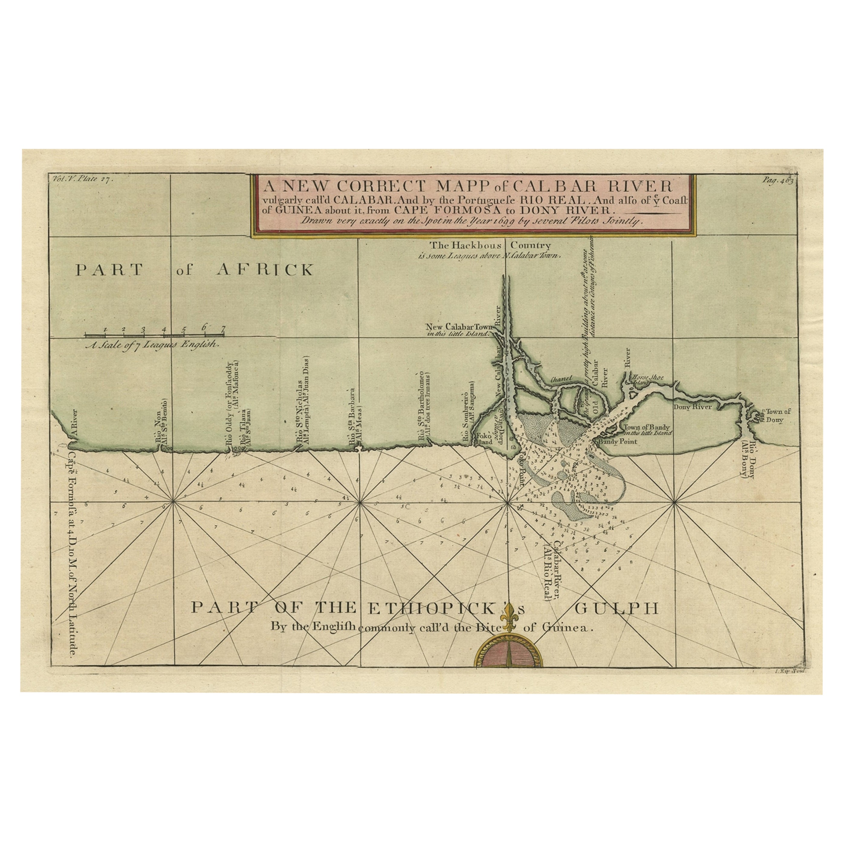
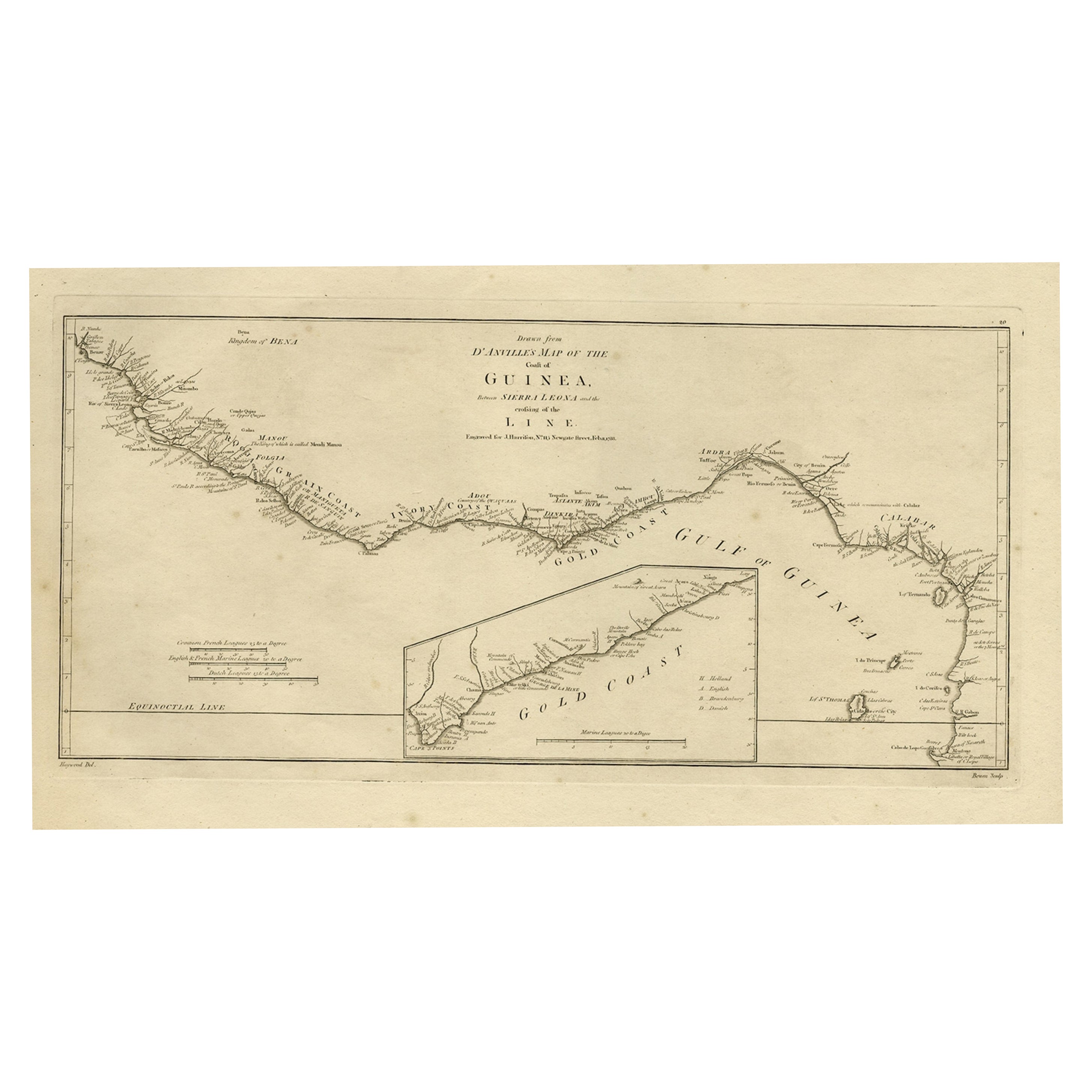
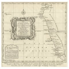
- Map of the African Coast, Gulf of Guinea, from Sierra Leone to Gabon, 1788Located in Langweer, NLAntique map titled 'Drawn from d'Anvilles Map of the Coast of Guinea, Between Sierra Leone and the crossing of the Line.' Map of the African coast, Gulf of Guinea, from Sierra Le...Category
Antique 1780s Maps
MaterialsPaper
- Antique Map of the West Coast of North America & North East Coast of Asia '1772'Located in Langweer, NLAntique map titled 'Carte des nouvelles decouvertes/ Extrait d'une Carte Japonoise de l'Universe'. Map of the West Coast of North America and North-East Coast of Asia, based upon Buache's report of the various Russian Discoveries between 1731 and 1742 including the various explorers routes and notes. The lower map is based upon a Japanese map...Category
Antique Late 18th Century Maps
MaterialsPaper
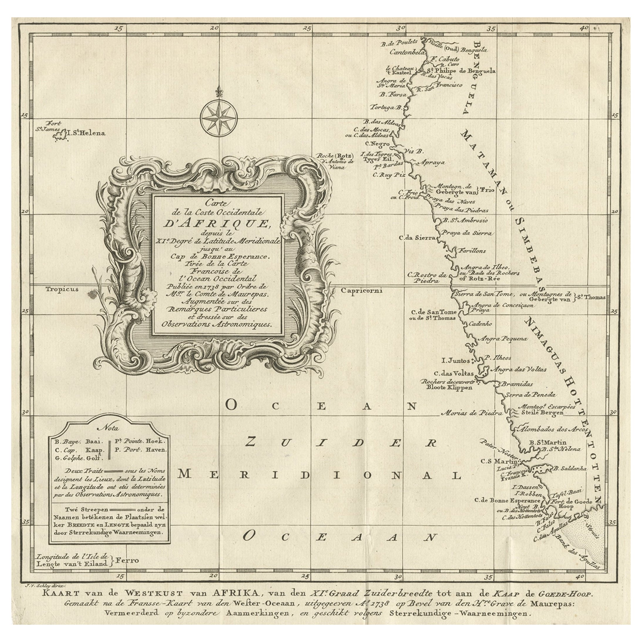
- Dutch Antique Map of the West Coast of Africa, to the Cape of Good Hope, 1747Located in Langweer, NLAntique map of the Coast of Africa titled 'Kaart van de West Kust van Afrika (..)'. Map of the west coast of Africa, from 11 degrees south latitude to the Cape of Good Hope. This...Category
Antique 1740s Maps
MaterialsPaper
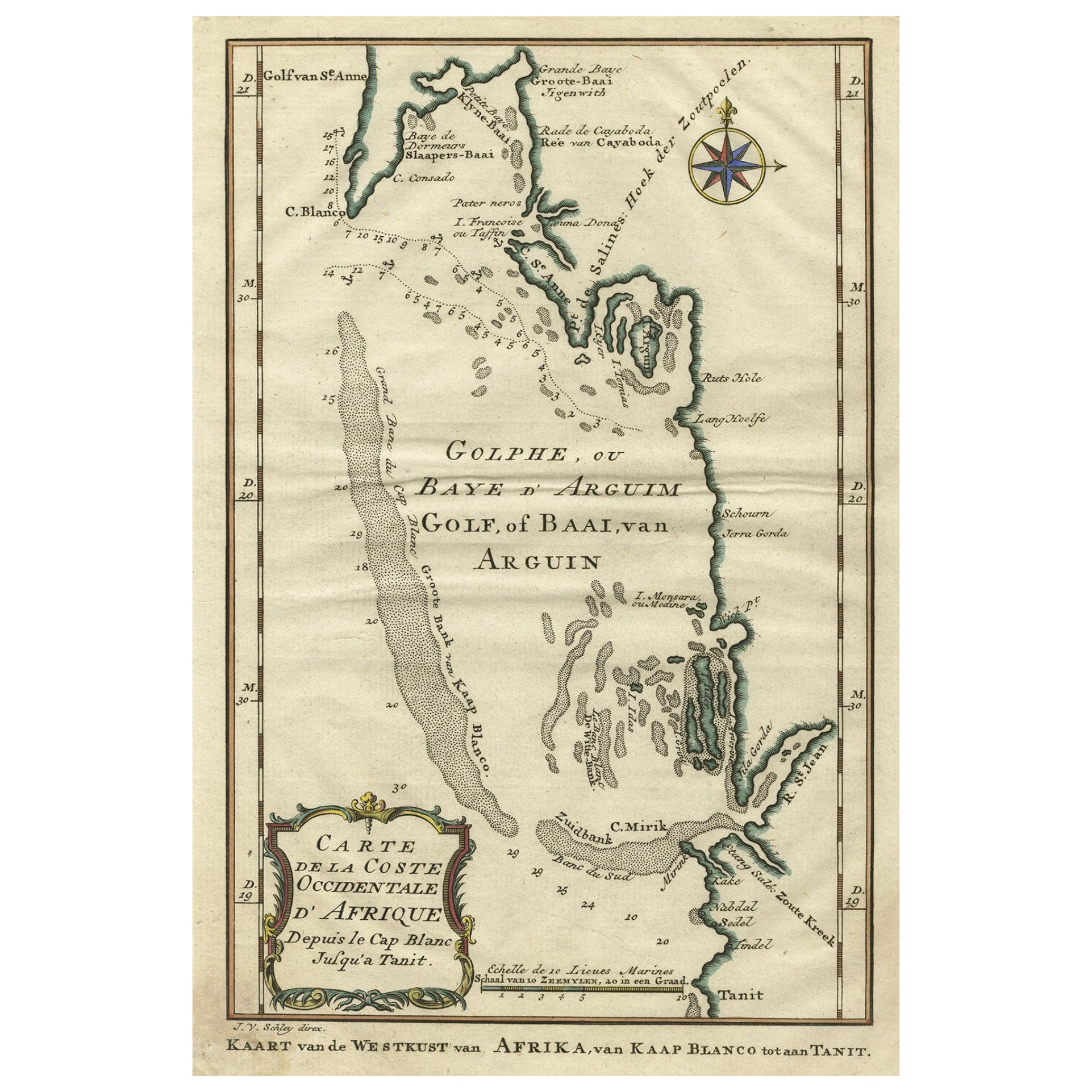
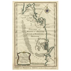
- Bay of Arguin, West Coast of Africa from Cape Blanco to Tanit, Africa, 1747Located in Langweer, NLAntique map titled 'Carte De La Coste Occidentale D'Afrique (..) Kaart van de Westkust van Afrika (..)'. Original antique map of the western coast of Africa. Shows the area aroun...Category
Antique 1740s Maps
MaterialsPaper
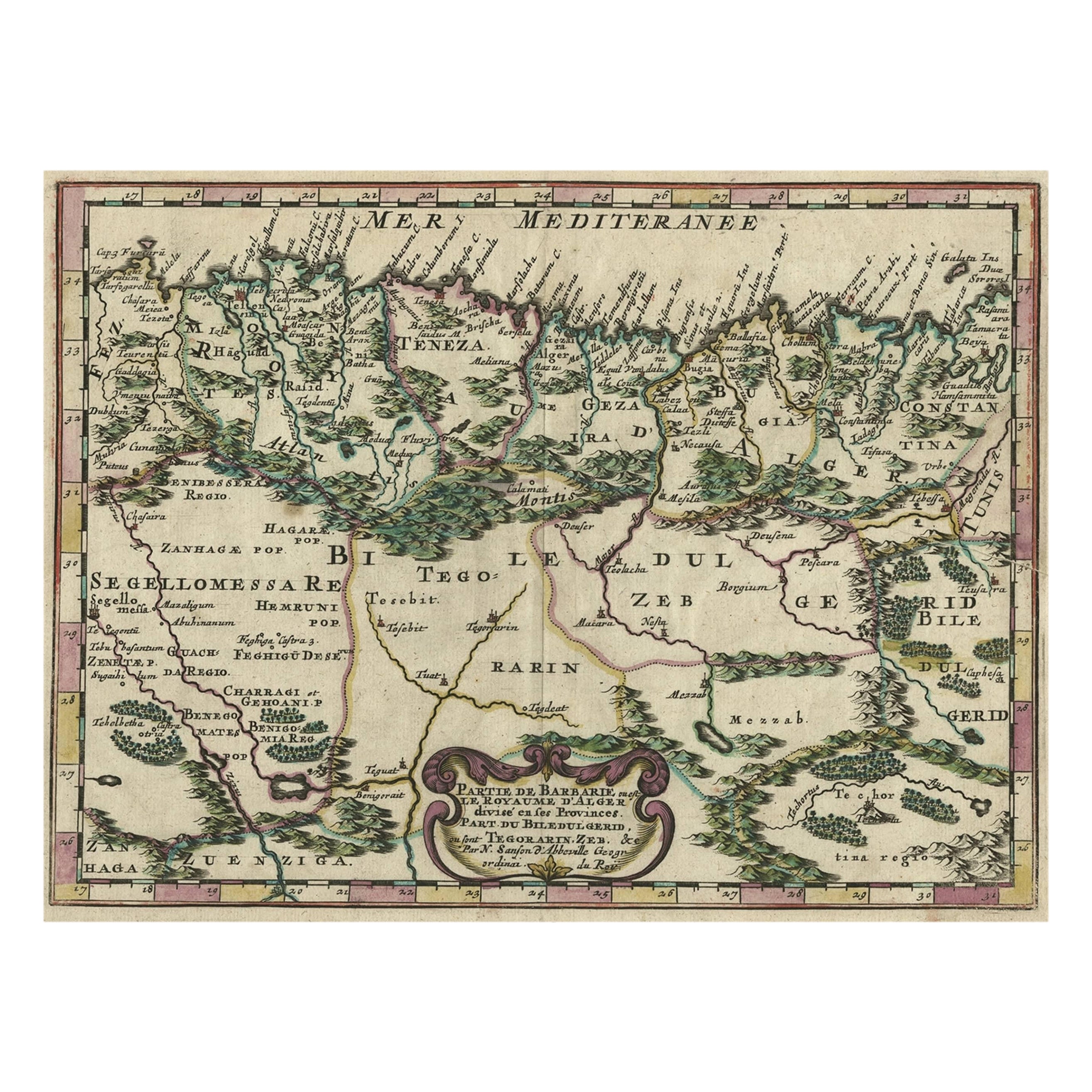
- Copper-Engraved Map Showing the Algerian Coast of North Africa, Published 1683Located in Langweer, NLAntique map titled 'Partie de Barbarie, ou est le Royaume d'Alger (..)'. Copper-engraved map showing the Algerian coast of North Africa. Published 1683. Artists and Engravers:...Category
Antique 1680s Maps
MaterialsPaper
- Antique Map of the West African Coast and the Cape Verde Islands, c.1680Located in Langweer, NLAntique map Africa titled 'Isles du Cap Verd Coste et Pays des Negres'. Antique map of the coast of Africa and the Cape Verde islands. Artists a...Category
Antique 17th Century Maps
MaterialsPaper

You May Also Like
- West Coast of Africa, Guinea & Sierra Leone: An 18th Century Map by BellinBy Jacques-Nicolas BellinLocated in Alamo, CAJacques Bellin's copper-plate map entitled "Partie de la Coste de Guinee Dupuis la Riviere de Sierra Leona Jusquau Cap das Palmas", depicting the coast of Guinea and Sierra Leone in ...Category
Antique Mid-18th Century French Maps
MaterialsPaper
- New Map of North America from the Latest Discoveries, 1763Located in Philadelphia, PAA fine antique 18th century map of the North American seaboard. Entitled "A New Map of North America from the Latest Discoveries 1763". By the Cartographer/Engraver - John Spil...Category
Antique Mid-18th Century English Georgian Maps
MaterialsPaper
- 17th Century Hand-Colored Map of West Africa by Mercator/HondiusLocated in Alamo, CAA 17th century hand-colored map entitled "Guineae Nova Descriptio" by Gerard Mercator and Jodocus Hondius, published in their 'Atlas Minor' in Amsterdam in 1635. It is focused on the...Category
Antique Mid-17th Century Dutch Maps
MaterialsPaper
- "Nova Barbariae Descriptio", a 17th Century Hand-Colored Map of North AfricaBy Johannes JanssoniusLocated in Alamo, CAThis original attractive 17th century hand-colored map of North Africa entitled "Nova Barbariae Descriptio" by Johannes Janssonius was published in Paris in 1635. It includes the Med...Category
Antique Mid-17th Century Dutch Maps
MaterialsPaper
- Large Antique 1859 Map of North AmericaLocated in Sag Harbor, NYThis Map was made by Augustus Mitchell in 1859 It is in amazing condition for being 163 years old. This price is for the rolled up easy to ship version of this piece. I will be Frami...Category
Antique Mid-19th Century American Maps
MaterialsCanvas, Paper

- West Africa Entitled "Guinea Propria": An 18th Century Hand Colored Homann MapBy Johann Baptist HomannLocated in Alamo, CAThis is a scarce richly hand colored copper plate engraved map of Africa entitled "Guinea Propria, nec non Nigritiae vel Terrae Nigrorum Maxima Pars" by Johann Baptist Homann (1664-1...Category
Antique Mid-18th Century German Maps
MaterialsPaper


Recently Viewed
View AllMore Ways To Browse
West African Furniture
Antique Furniture North West
Africa Antique Map
Antique Map Africa
Antique Map Of Africa
Antique Maps Of Africa
West African Antiques
Harrison Antique Furniture
North Africa Map
Harrisons Antiques
J Harrison
Western Cape
West Africa Map
Blanco River
Antique Blanco
Antique Furniture Western Cape
Gambia Antique Map
Guinea Bissau