Items Similar to Old Coloure Map of North & Central Italy & Corsica with an Inset of Rome, c.1860


Want more images or videos?
Request additional images or videos from the seller
1 of 6
Old Coloure Map of North & Central Italy & Corsica with an Inset of Rome, c.1860
About the Item
Antique map titled 'North & Central Italy and the Island of Corsica'.
Old map of North and Central Italy, and the island of Corsica. With an inset map of the region of Rome. Originates from 'The Royal Atlas Of Modern Geography Exhibiting, In A Series Of Entirely Original And Authentic Maps, The Present Condition Of Geographical Discovery And Research In The Several Countries, Empires, And States Of The World By Alexander Keith Johnston'.
Artists and Engravers: Alexander Keith Johnston LLD (1804-1871) was a Scottish geographer. He was a pupil of the Edinburgh engraver and mapmaker, James Kirkwood. In 1826, he joined his brother William (who would become Sir William Johnston, Lord Provost of Edinburgh) in a printing and engraving business, forming the well-known cartographical firm of W. and A. K. Johnston.
Condition: Very good, given age. Original middle fold, as issued. Minimal paper separation in lower and top middle fold margin, backed. Small tear in bottom paper edge, not effecting image. Contemporary hand coloring. General age-related toning and/or occasional minor defects from handling. Please study scan carefully.
- Dimensions:Height: 19.38 in (49.2 cm)Width: 24.41 in (62 cm)Depth: 0 in (0.02 mm)
- Materials and Techniques:
- Period:
- Date of Manufacture:circa 1860
- Condition:
- Seller Location:Langweer, NL
- Reference Number:
About the Seller
5.0
Platinum Seller
These expertly vetted sellers are 1stDibs' most experienced sellers and are rated highest by our customers.
Established in 2009
1stDibs seller since 2017
1,938 sales on 1stDibs
Typical response time: <1 hour
- ShippingRetrieving quote...Ships From: Langweer, Netherlands
- Return PolicyA return for this item may be initiated within 14 days of delivery.
More From This SellerView All
- Antique Map of France with an Inset Map of the Island of Corsica, c.1820Located in Langweer, NLAntique map titled 'Frankrijk naar de nieuwste bepalingen meerendeels gevolgd naar Lapie'. Beautiful map of France with an inset map of the island of Corsica. Includes a table with r...Category
Antique 19th Century Maps
MaterialsPaper
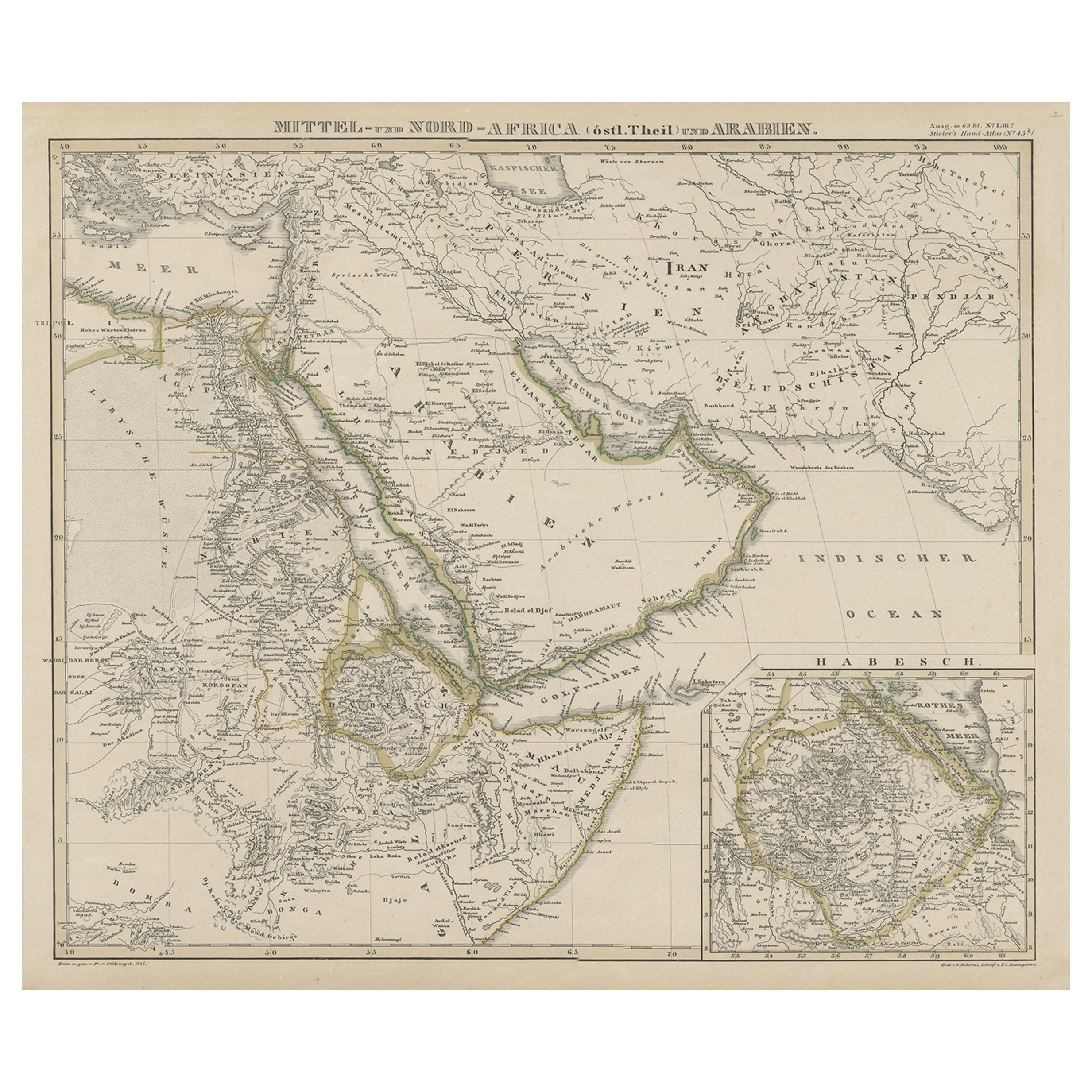
- North & Central Africa & Arabia, Inset Map of Habesch 'Ethiopia & Eritrea', 1845Located in Langweer, NLAntique map titled 'Mittel- und Nord-Africa (östl. Theil) und Arabien'. This map depicts North and Central Africa and Arabia with an inset map of Habesch (Ethiopia and Eritrea). ...Category
Antique 1840s Maps
MaterialsPaper
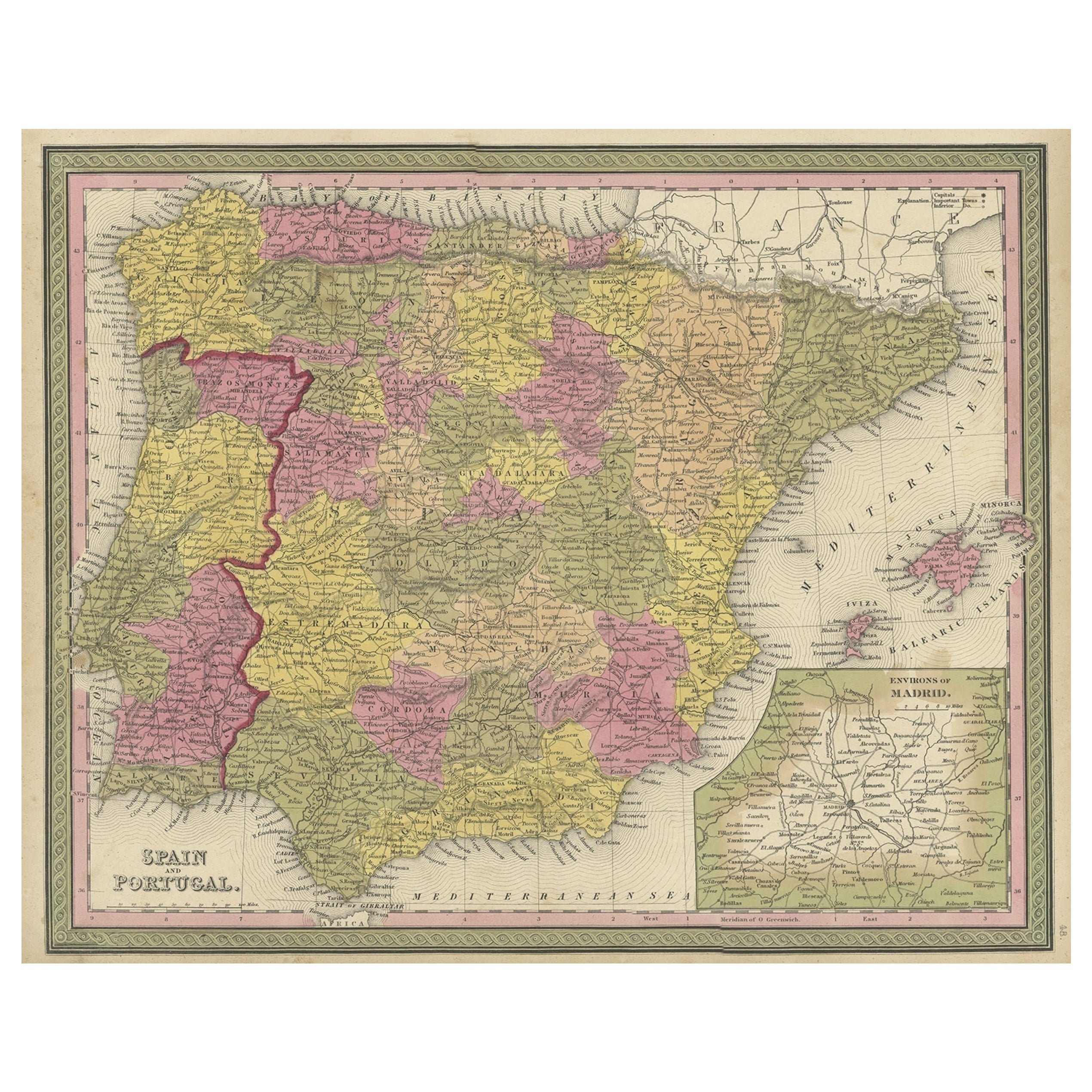
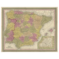
- Old Map of Spain and Portugal, with an Inset Map of the Region of Madrid, 1846Located in Langweer, NLAntique map titled 'Kingdom of Spain and Portugal'. Old map of Spain and Portugal, with an inset map of the region of Madrid. This map originates from 'A New Universal Atlas Cont...Category
Antique 1840s Maps
MaterialsPaper
- Old Map of the East Coast of Honshu with an Inset, Japan, c.1785Located in Langweer, NLAntique map titled ‘Part of Japan or Nippon'. View of the Coast of Japan when we first saw it: The Hill a bearing West 3 miles distant. London Published by Allexer Hogg at the Kings Arms...Category
Antique 1780s Maps
MaterialsPaper
- Antique Map of Greece with an Inset Map of Corfu, 1854Located in Langweer, NLAntique map titled 'Hellas or Greece'. Old map of Greece with an inset map of Corfu. This map orginates from 'General Atlas Of The World: Containing Upwards Of Seventy Maps (..)' by ...Category
Antique 19th Century Maps
MaterialsPaper
- Antique Map of Denmark with an Inset Map of Iceland, 1832Located in Langweer, NLAntique map titled 'Denmark'. Large map of Denmark with an inset map of Iceland. Artists and Engravers: Published by J. Arrowsmith in London, 1832. Condition: Good, general age...Category
Antique 19th Century Maps
MaterialsPaper


You May Also Like
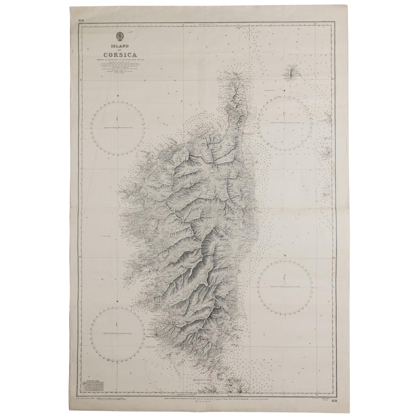
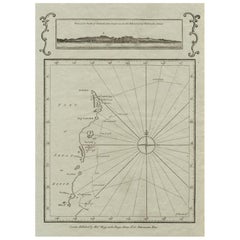
- Old Nautical Map of CorsicaLocated in Alessandria, PiemonteST/556/1 - Old map of Corsica isle, surveyed by Captain Hell, of the French Royal Navy in 1824, engraved and published on 1874, with additions and corre...Category
Antique Early 19th Century English Other Prints
MaterialsPaper
- Italy, Sicily, Sardinia, Corsica and Dalmatian Coast: A 17th Century Dutch MapBy Theodorus DanckertsLocated in Alamo, CAThis hand colored 17th century Dutch map entitled "Novissima et Accuratissima totius Italiae Corsicae et Sardiniae Descriptio" by Theodore Danckerts depicts the Italian Peninsula in ...Category
Antique Late 17th Century Dutch Maps
MaterialsPaper
- Large Antique 1859 Map of North AmericaLocated in Sag Harbor, NYThis Map was made by Augustus Mitchell in 1859 It is in amazing condition for being 163 years old. This price is for the rolled up easy to ship version of this piece. I will be Frami...Category
Antique Mid-19th Century American Maps
MaterialsCanvas, Paper

- Old Horizontal Map of EnglandBy TassoLocated in Alessandria, PiemonteST/520 - Old rare Italian map of England, dated 1826-1827 - by Girolamo Tasso, editor in Venise, for the atlas of M.r Le-Sage.Category
Antique Early 19th Century Italian Other Prints
MaterialsPaper
- Original Antique Map of Central America / Florida, Arrowsmith, 1820Located in St Annes, LancashireGreat map of Central America. Drawn under the direction of Arrowsmith. Copper-plate engraving. Published by Longman, Hurst, Rees, Orme and Brown, 1820 Unframed.Category
Antique 1820s English Maps
MaterialsPaper
- New Map of North America from the Latest Discoveries, 1763Located in Philadelphia, PAA fine antique 18th century map of the North American seaboard. Entitled "A New Map of North America from the Latest Discoveries 1763". By the Cartographer/Engraver - John Spil...Category
Antique Mid-18th Century English Georgian Maps
MaterialsPaper


