Items Similar to Old Map of Ancient Rome Illustrating Major Monuments and the Seven Hills, c.1704
Want more images or videos?
Request additional images or videos from the seller
1 of 5
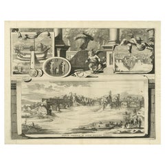
Old Map of Ancient Rome Illustrating Major Monuments and the Seven Hills, c.1704
About the Item
Antique map Rome titled 'Omnia Romanae cedant Miracula Terrae (..)'. Map of Ancient Rome Illustrating Major Monuments and the Seven Hills. This map originates from 'Beschryving van Oud en Nieuw Rome (..)' published by F. Halma.
Artists and Engravers: Jan Goeree (1670-1731) was a Dutch engraver and poet. He was the son of the Middelburg bookseller Willem Goeree.
Condition: Very good, general age-related toning. Please study image carefully.
Date: c.1704
Overall size: 36 x 24.5 cm.
Image size: 33.5 x 21.5 cm.
We sell original antique maps to collectors, historians, educators and interior decorators all over the world. Our collection includes a wide range of authentic antique maps from the 16th to the 20th centuries. Buying and collecting antique maps is a tradition that goes back hundreds of years. Antique maps have proved a richly rewarding investment over the past decade, thanks to a growing appreciation of their unique historical appeal. Today the decorative qualities of antique maps are widely recognized by interior designers who appreciate their beauty and design flexibility. Depending on the individual map, presentation, and context, a rare or antique map can be modern, traditional, abstract, figurative, serious or whimsical. We offer a wide range of authentic antique maps for any budget.
- Dimensions:Height: 9.65 in (24.5 cm)Width: 14.18 in (36 cm)Depth: 0 in (0.01 mm)
- Materials and Techniques:
- Period:
- Date of Manufacture:circa 1704
- Condition:
- Seller Location:Langweer, NL
- Reference Number:
About the Seller
5.0
Platinum Seller
These expertly vetted sellers are 1stDibs' most experienced sellers and are rated highest by our customers.
Established in 2009
1stDibs seller since 2017
1,933 sales on 1stDibs
Typical response time: <1 hour
- ShippingRetrieving quote...Ships From: Langweer, Netherlands
- Return PolicyA return for this item may be initiated within 14 days of delivery.
More From This SellerView All
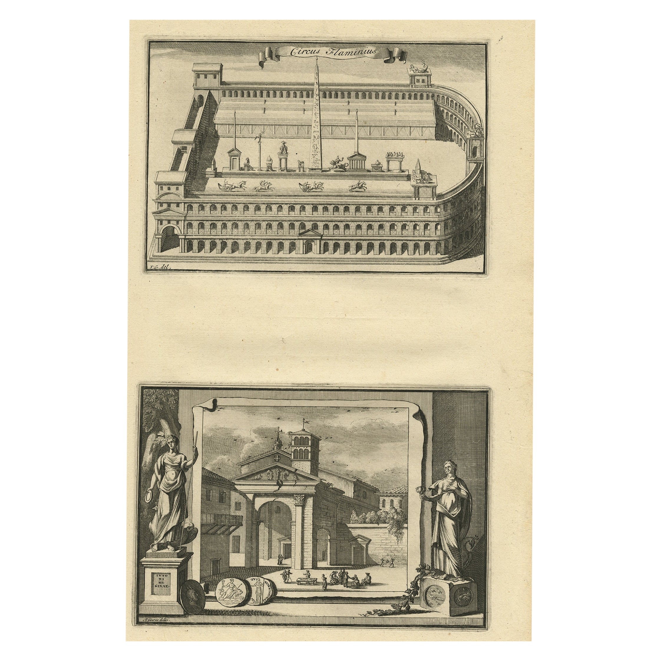
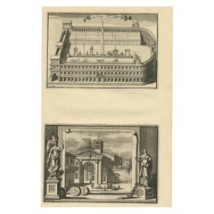
- Antique Engraving of Circus Flaminius, a Circular Area in Ancient Rome, 1704Located in Langweer, NLDescription: Antique print, titled: 'Circus Flaminius (…)' - This original old antique print shows a reconstruction of Circus Flaminius, a large, circular area in ancient Rome, l...Category
Antique Early 1700s Prints
MaterialsPaper
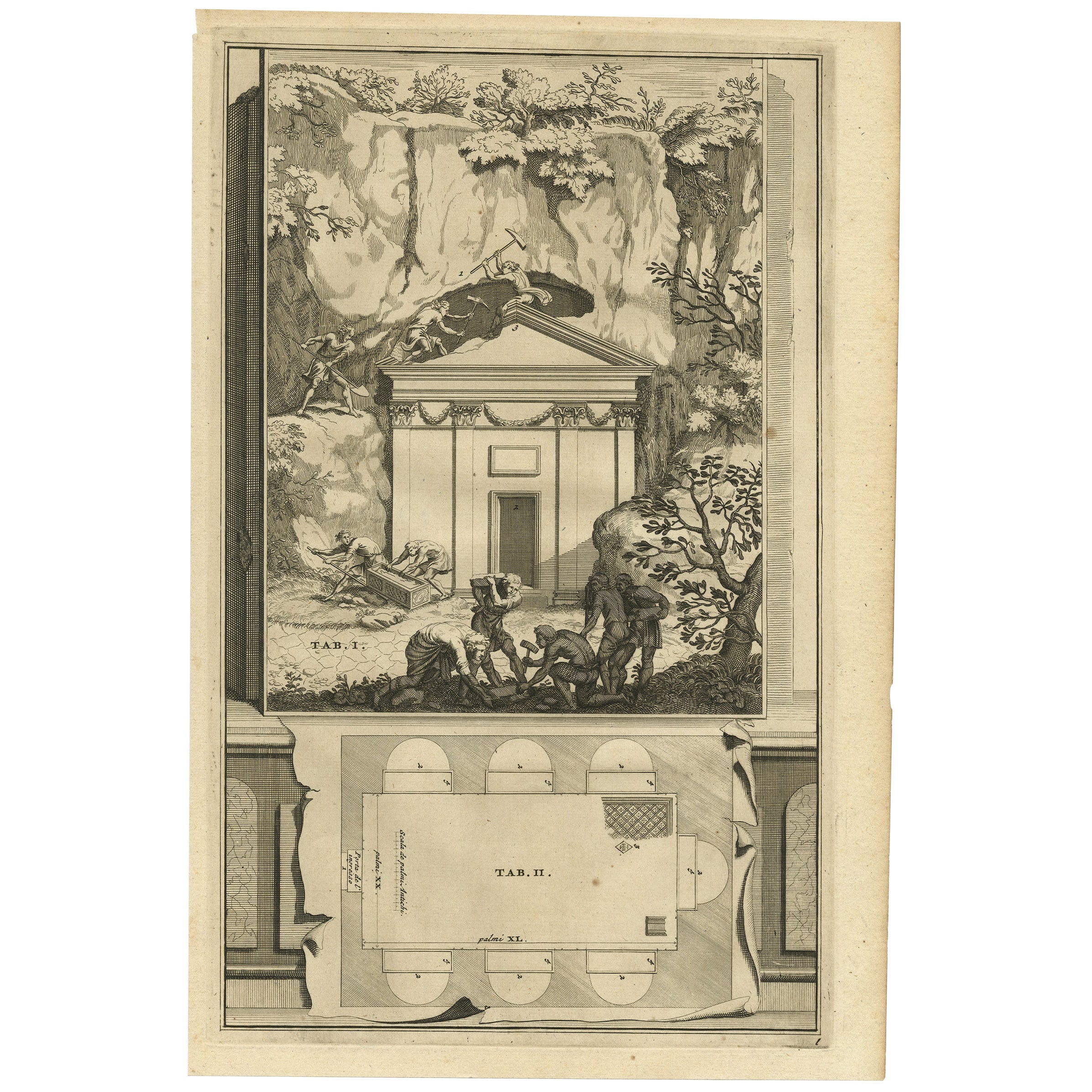
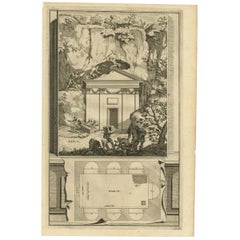
- Antique Print of An Ancient Roman Tomb and a Floor Plan in Rome, Italy, 1704Located in Langweer, NLDescription: Antique print, untitled. This original old antique print shows an ancient Roman tomb and a floor plan in Rome, Italy. This original old ant...Category
Antique Early 1700s Prints
MaterialsPaper
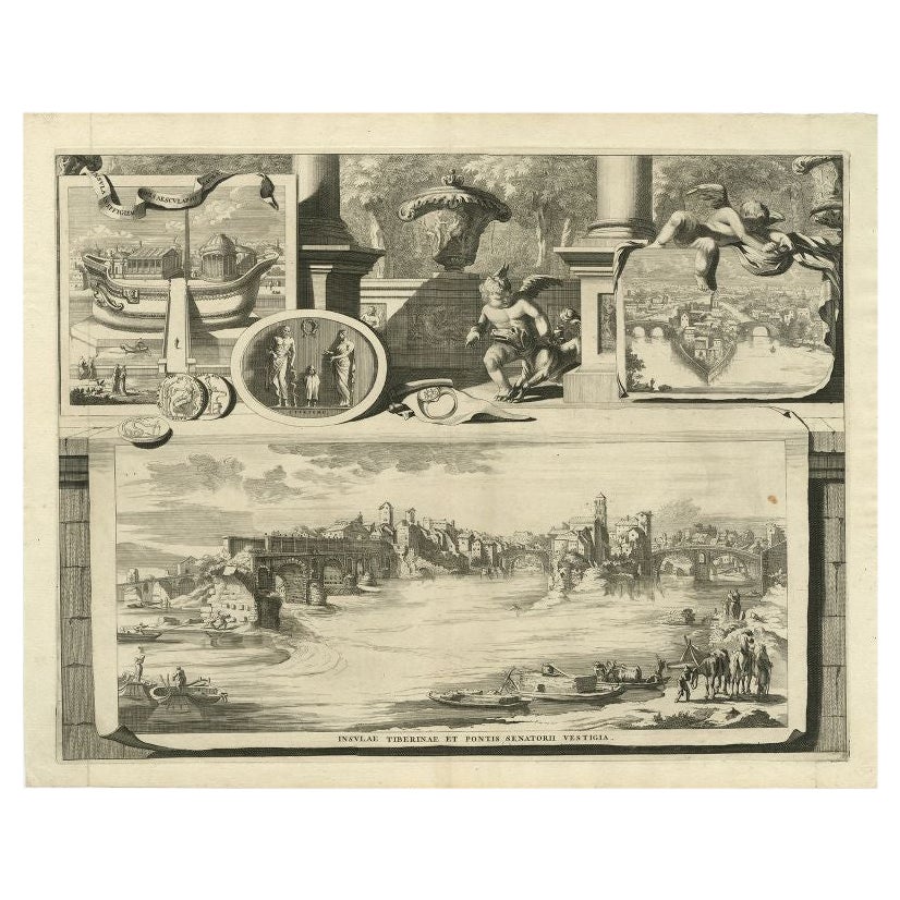
- Antique Print of the Tiber River in Rome, Italy, 1704Located in Langweer, NLAntique print titled 'Insulae Tiberinae et Pontis Senatorii Vestigia'. This original antique print shows a view of the Tiber River in Rome with the Bridge 'Ponte dei Senatori'. Above more images of Rome. Originates from 'Beschryving van Oud en Nieuw Rome. Verdeelt in drie Deelen. In 't Fransch beschreven door den Heer Francois Desseine. En in 't Nederduitsch vertaalt.', by Francois Desseine and published by Francois Halma in 1704, first published in French in 1690. Copies of this work are rarely complete as the maps and engravings are of high quality matching the work of Piranesi. Artists and Engravers: Jan Goeree (1670-1731) was a Dutch engraver and poet. He was the son of the Middelburg bookseller Willem Goeree. Born in Middelburg, but soon they moved to Amsterdam. Initially he focussed on painting, assumably a student of Gerard de Lairesse...Category
Antique 18th Century Prints
MaterialsPaper
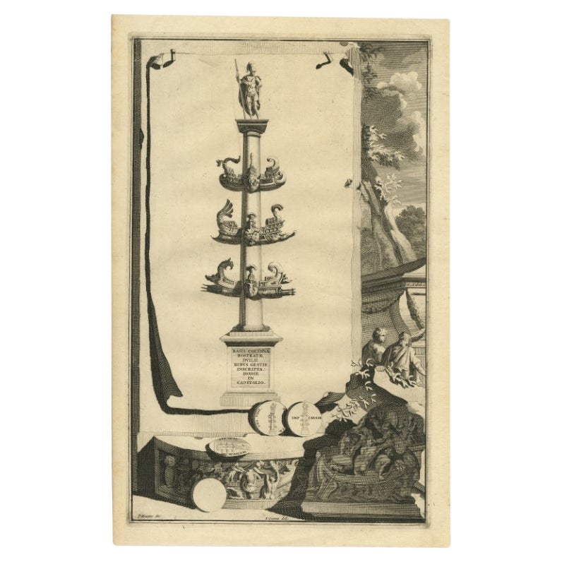
- Old Antique Print showing a Rostral Column in Rome, Italy, 1704Located in Langweer, NLAntique print, titled: 'Basis Columnae Rostratae (?)' - This original old antique print shows a rostral column in Rome, Italy. It is a type of victory column, originating in ancient Greece and Rome where they were erected to commemorate a naval military victory. This original old antique print / plate originates from: 'Beschryving van Oud en Nieuw Rome. Verdeelt in drie Deelen. In 't Fransch beschreven door den Heer Francois Desseine. En in 't Nederduitsch vertaalt.', by Francois Desseine and published by Francois Halma in 1704, first published in French in 1690. Copies of this work are rarely complete as the maps and engravings are of high quality matching the work of Piranesi. Artists and Engravers: Made by 'P. Sluiter' after 'Jan Goeree'. Made by P. Sluiter after Jan Goeree. Jan Goeree (1670-1731) was a Dutch engraver and poet. He was the son of the Middelburg bookseller Willem Goeree. Born in Middelburg, but soon they moved to Amsterdam. Initially he focussed on painting, assumably a student of Gerard de Lairesse. But he is best known for his engraving skills, depicting mosttly emblematic and historic scenes. In 1705 he was commisioned by the Mayor of Amsterdam to design the drawings for the ceiling paintings for the grand hall of the old city hall...Category
Antique 18th Century Prints
MaterialsPaper
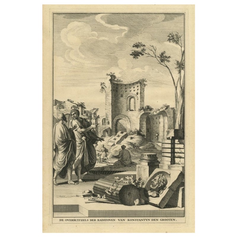
- Antique Print Showing Remnants of Constantine I the Great's Baths, Rome, 1704Located in Langweer, NLAntique print, titled: 'De Overblyfzels der Badstoven van Konstantyn den Grooten' - This original old antique print shows the remnants of Constantine I the Great's baths in Rome, Ita...Category
Antique 18th Century Prints
MaterialsPaper
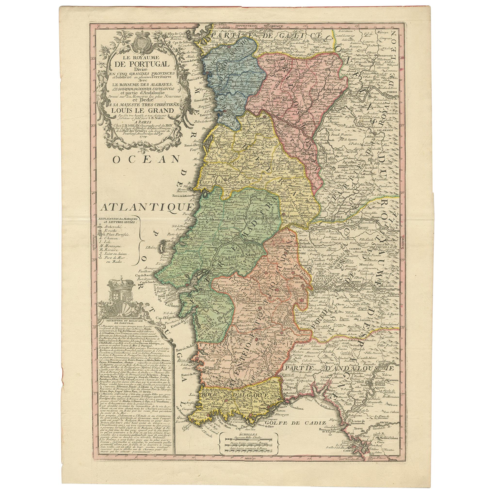
- Antique Map of Portugal by Nolin '1704'Located in Langweer, NLAntique map titled 'Le Royaume de Porutgal divisé en cinq grandes Provinces (..)'. Rare and very decorative map of Portugal. It shows the territory of ...Category
Antique Early 18th Century Maps
MaterialsPaper


You May Also Like
- Old Nautical Map of CorsicaLocated in Alessandria, PiemonteST/556/1 - Old map of Corsica isle, surveyed by Captain Hell, of the French Royal Navy in 1824, engraved and published on 1874, with additions and corre...Category
Antique Early 19th Century English Other Prints
MaterialsPaper
- Old Horizontal Map of EnglandBy TassoLocated in Alessandria, PiemonteST/520 - Old rare Italian map of England, dated 1826-1827 - by Girolamo Tasso, editor in Venise, for the atlas of M.r Le-Sage.Category
Antique Early 19th Century Italian Other Prints
MaterialsPaper
- Original Antique Map of Ancient Greece, Achaia, Corinth, 1786Located in St Annes, LancashireGreat map of Ancient Greece. Showing the region of Thessaly, including Mount Olympus Drawn by J.D. Barbie Du Bocage Copper plate engraving by P.F Tardieu Original hand color...Category
Antique 1780s French Other Maps
MaterialsPaper
- Original Antique Map of Ancient Greece- Boeotia, Thebes, 1787Located in St Annes, LancashireGreat map of Ancient Greece. Showing the region of Boeotia, including Thebes Drawn by J.D. Barbie Du Bocage Copper plate engraving by P.F T...Category
Antique 1780s French Other Maps
MaterialsPaper
- Map of the Republic of GenoaLocated in New York, NYFramed antique hand-coloured map of the Republic of Genoa including the duchies of Mantua, Modena, and Parma. Europe, late 18th century. Dimension: 25...Category
Antique Late 18th Century European Maps
- Original Antique Map of Ancient Greece, Phocis, Gulf of Corinth, 1787Located in St Annes, LancashireGreat map of Ancient Greece. Showing the region of Phocis, including the Gulf of Corinth Drawn by J.D. Barbie Du Bocage Copper plate engraving by P.F Tardieu Original hand c...Category
Antique 1780s French Other Maps
MaterialsPaper


