Items Similar to Old Map of The Frisian City of Workum in Holland, 1916
Want more images or videos?
Request additional images or videos from the seller
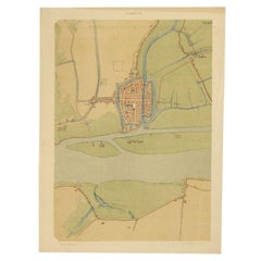
Old Map of The Frisian City of Workum in Holland, 1916
About the Item
Antique map Workum titled 'Workum'. Antique map depicting the Frisian city of Workum, the Netherlands.
Artists and Engravers: Lithograph by J. Smulders & Co, Den Haag.
Condition: Good, age-related toning. Please study image carefully.
Date: 1916
Overall size: 35 x 45 cm
Image size: 29 x 38 cm.
- Dimensions:Height: 17.72 in (45 cm)Width: 13.78 in (35 cm)Depth: 0.01 in (0.2 mm)
- Materials and Techniques:
- Period:
- Date of Manufacture:1916
- Condition:
- Seller Location:Langweer, NL
- Reference Number:
About the Seller
5.0
Platinum Seller
These expertly vetted sellers are 1stDibs' most experienced sellers and are rated highest by our customers.
Established in 2009
1stDibs seller since 2017
1,950 sales on 1stDibs
Typical response time: <1 hour
- ShippingRetrieving quote...Ships From: Langweer, Netherlands
- Return PolicyA return for this item may be initiated within 14 days of delivery.
More From This SellerView All
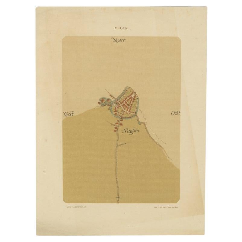
- Old Map of the Dutch City of Megen in Holland, 1916Located in Langweer, NLAntique map Megen titled 'Megen'. Antique map depicting the city of Megen, Noord-Brabant, The Netherlands. Artists and Engravers: Lithograph by J. Smulders & Co, Den Haag. Con...Category
20th Century Maps
MaterialsPaper
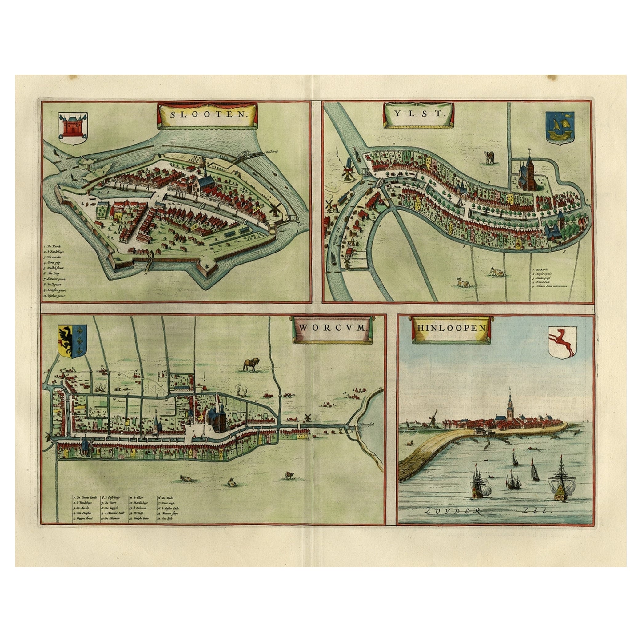
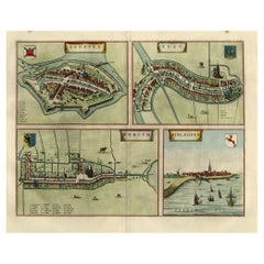
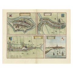
- Antique Map of Frisian Cities Sloten, Ylst, Workum and Hindelopen by Blaeu, 1652Located in Langweer, NLAntique print titled 'Slooten - Ylst - Worcum - Hinloopen'. Three plans and a bird's eye view on one sheet. The plans show the Frisian cities Sloten, IJlst, Workum and the view shows...Category
Antique 1650s Maps
MaterialsPaper
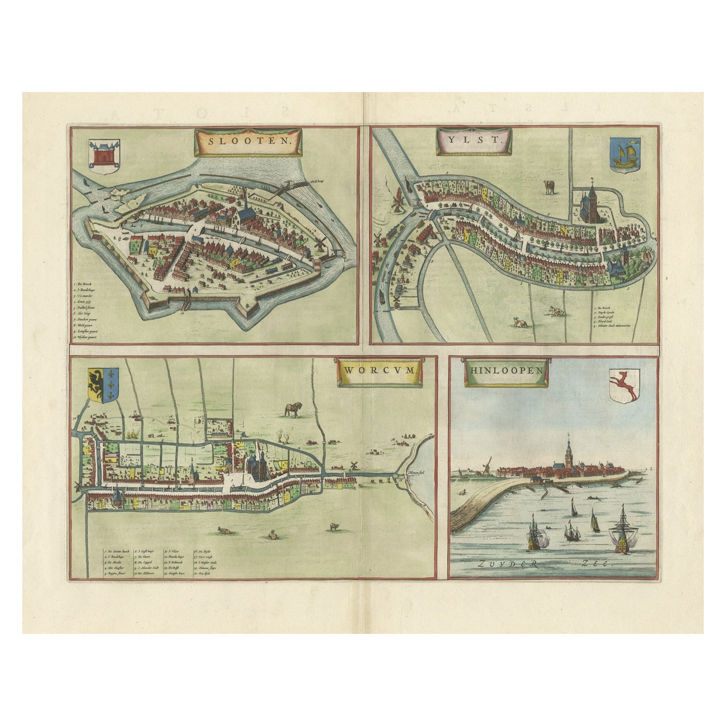
- Engravings of the Frisian Cities of Sloten, IJlst, Workum and Hindelopen, c.1650Located in Langweer, NLAntique print titled 'Slooten - Ylst - Worcum - Hinloopen'. Three plans and a bird's eye view on one sheet. The plans show the Frisian cities Sloten, IJlst, Workum and the view shows...Category
Antique 17th Century Prints
MaterialsPaper
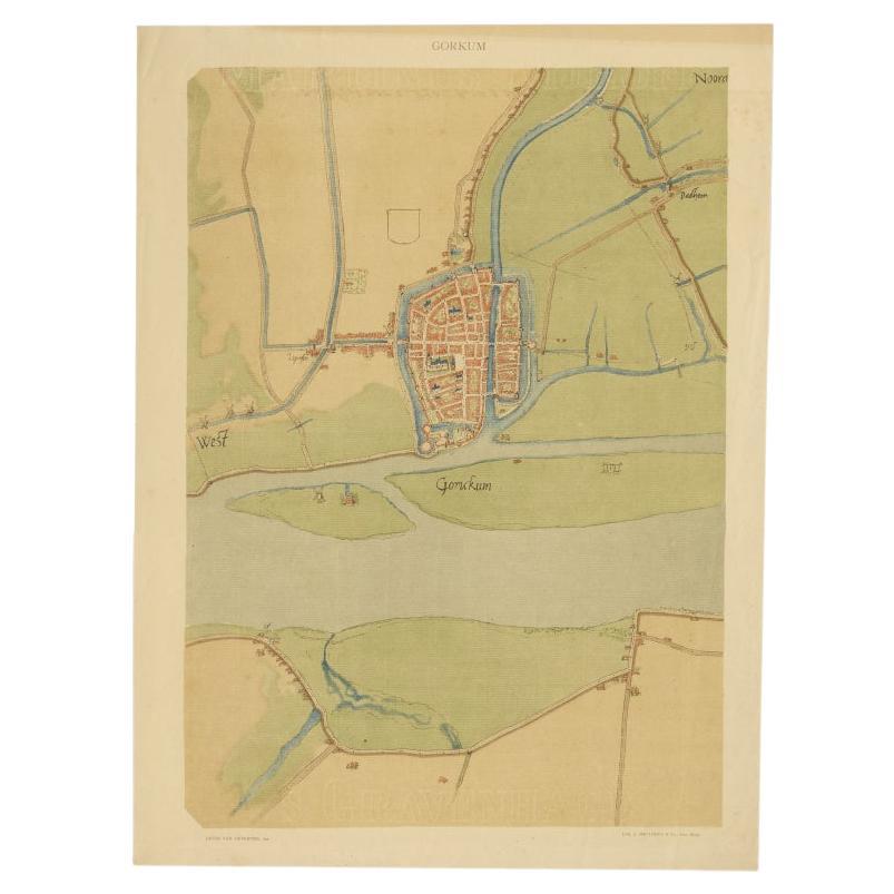
- Antique Map of The Dutch City of Gorinchem by Smulders, Lithograph, 1916Located in Langweer, NLAntique map Gorinchem titled 'Gorkum'. Antique map depicting the city of Gorinchem, The Netherlands. Artists and Engravers: Lithograph by J. Smulders & Co, Den Haag. Condition...Category
20th Century Maps
MaterialsPaper
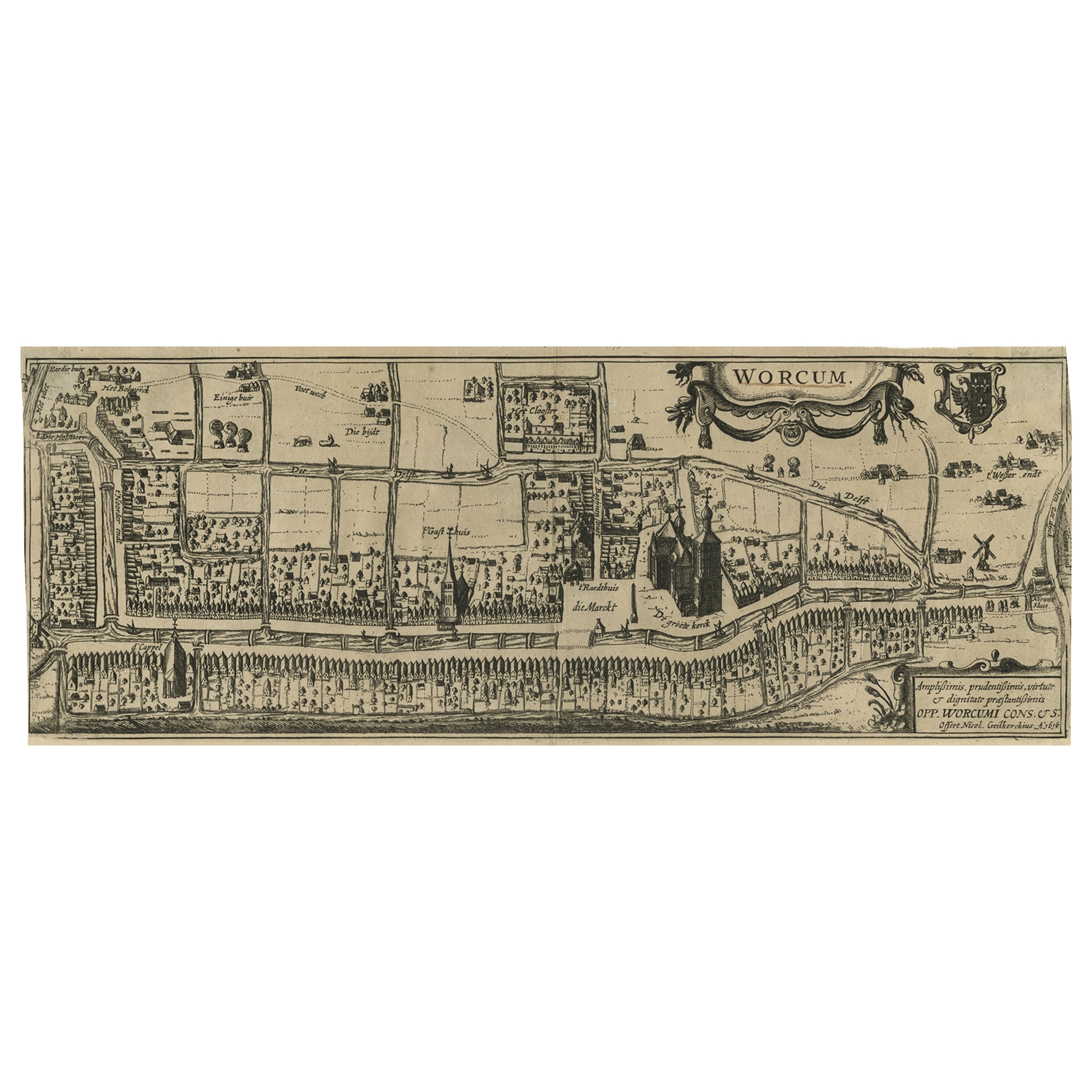
- Original Old & Rare View of the City of Workum, Friesland, The Netherlands, 1616Located in Langweer, NLAntique map titled 'Worcum'. This print depicts the city of Workum (Friesland, The Netherlands). With German captions. This print originates from 'Rerum Frisicarum Historia' publishe...Category
Antique 1610s Maps
MaterialsPaper
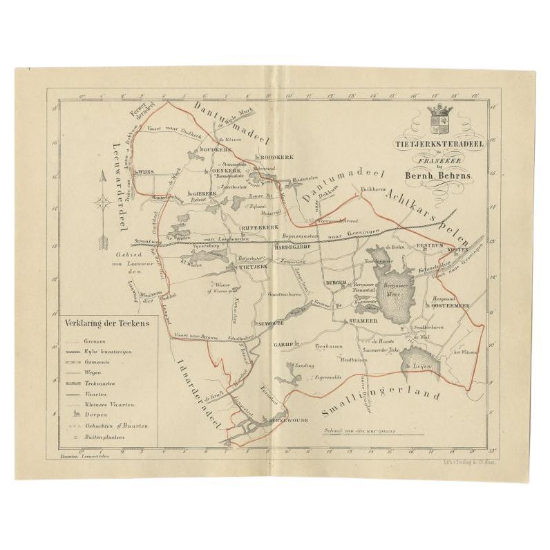
- Antique Map of the Frisian Tietjerksteradeel Township in the Netherlands, 1861Located in Langweer, NLAntique map titled 'Gemeente Tietjerksteradeel'. Old map depicting the Tietjerksteradeel township including cities and villages like Wijns, Oenkerk, Rijperkerk, Hardegarijp, Tietjerk...Category
Antique 19th Century Maps
MaterialsPaper


You May Also Like
- Old Nautical Map of CorsicaLocated in Alessandria, PiemonteST/556/1 - Old map of Corsica isle, surveyed by Captain Hell, of the French Royal Navy in 1824, engraved and published on 1874, with additions and corre...Category
Antique Early 19th Century English Other Prints
MaterialsPaper
- Old Horizontal Map of EnglandBy TassoLocated in Alessandria, PiemonteST/520 - Old rare Italian map of England, dated 1826-1827 - by Girolamo Tasso, editor in Venise, for the atlas of M.r Le-Sage.Category
Antique Early 19th Century Italian Other Prints
MaterialsPaper
- Dutch Map and City Plan of La Roche-sur-Foron, France, 17th Century Hand ColoredBy Coenraet DeckerLocated in Alamo, CA"Rupes Allobrogum vulgo La Roche" by Dutch engraver Coenraet Decker (1650-1685) is from the atlas Theatrum Statuum Regiae Celestudinis Sabaudiae Ducis, published in 1682. This richly...Category
Antique Late 17th Century Dutch Maps
MaterialsPaper
- The Holy Land at the Time of Jesus: A 17th Century Dutch Map by VisscherBy Nicolaes Visscher IILocated in Alamo, CAThis detailed Dutch map entitled "Het Beloofe de Landt Canaan door wandelt van onsen Salichmaecker Iesu Christo, nessens syne Apostelen" by Nicolaes Visscher was published in Amsterd...Category
Antique Mid-17th Century Dutch Maps
MaterialsPaper
- Map of the Republic of GenoaLocated in New York, NYFramed antique hand-coloured map of the Republic of Genoa including the duchies of Mantua, Modena, and Parma. Europe, late 18th century. Dimension: 25...Category
Antique Late 18th Century European Maps
- Map "Estuary- Mouth of the Thames"Located in Alessandria, PiemonteST/426 - Antique French Map of the estuary of the Thames, map dated 1769 - "Mape of the entrance of the Thames. Designed by filing of Navy cards fo...Category
Antique Mid-18th Century French Other Prints
MaterialsPaper


Recently Viewed
View AllMore Ways To Browse
1916 Furniture
The Vintage Map
Vintage City Maps
Vintage J 45
Lithograph City Maps
City Map Lithograph
Den Haag
Vintage Den Haag
Old Vintage City Maps
Vintage Furniture Den Haag
Antique Furniture In Edinburgh
Victorian Tear
Antique Framed Maps
Antique Maps Framed
Antique Map Framers
Map Globe
Globe Map
Framed Antique Maps