Items Similar to Rare and Early Plaster Relief Map of Adirondack Mountains by F J H Merrill


Want more images or videos?
Request additional images or videos from the seller
1 of 14
Rare and Early Plaster Relief Map of Adirondack Mountains by F J H Merrill
About the Item
Rare and Early Monumental Plaster Relief Map of Adirondack Mountains by The University of the State of New York, New York State Museum..F J H Merrill director,,,modeled by Howell's Microcosm,,, Stunning example,, my guess made Turn of the 19th Century,,Photos do no justice,,.Please zoom in on photos to check the amazing detail,, Hand delivery avail to New York City or anywhere en route from Buffalo NY
- Creator:P.F. Howells (Artist),E. W. Merrill (Author)
- Dimensions:Height: 63 in (160.02 cm)Width: 44 in (111.76 cm)Depth: 5 in (12.7 cm)
- Style:Industrial (Of the Period)
- Materials and Techniques:
- Place of Origin:
- Period:1910-1919
- Date of Manufacture:1911
- Condition:Wear consistent with age and use. Minor structural damages. minor damage to upper left corner..
- Seller Location:Buffalo, NY
- Reference Number:1stDibs: LU1062434899242
About the Seller
4.3
Vetted Seller
These experienced sellers undergo a comprehensive evaluation by our team of in-house experts.
Established in 1987
1stDibs seller since 2014
1,126 sales on 1stDibs
Typical response time: 4 hours
- ShippingRetrieving quote...Ships From: Buffalo, NY
- Return PolicyThis item cannot be returned.
More From This SellerView All
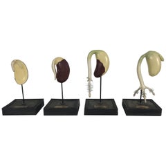
- Emile Deyrolle 19th Century Plaster, Wire and Wood Didactic Germination ModelsBy Emile DeyrolleLocated in Buffalo, NYLES FILS D'EMILE DEYROLLE, PARIS. Extremely rare set of four 19th century French painted plaster, wire and wood Didactic models depicting progression, ANATOMIE VEGETALE, beautifully ...Category
Antique Late 19th Century French Folk Art Models and Miniatures
MaterialsWire
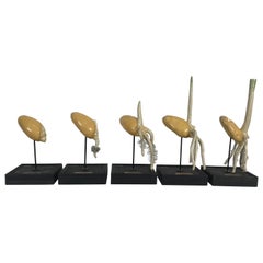
- Emile Deyrolle 19th Century Plaster, Wire and Wood Didactic Germination ModelsBy Emile DeyrolleLocated in Buffalo, NYLes Fils D'Emile Deyrolle, Paris. Extremely rare set of five 19th century French painted plaster, wire and wood Didactic models depicting progression, Anatomie Vegetalf, beautifully ...Category
Antique 19th Century French Folk Art Scientific Instruments
MaterialsWire
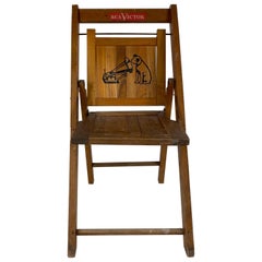
- Rare RCA Victor Childs Folding Chair, Nipper Dog and HornBy RCA VictorLocated in Buffalo, NYRare RCA Victor Childs folding chair, nipper dog and horn. I’ve only seen one other in 40 years, Classic 1930s childs size folding chair with original RCA V...Category
Vintage 1930s American Art Deco Children's Furniture
MaterialsWood
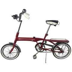
- Rare Hi-Lo Collapsible Modernist Bicycle by Cleveland Company MDTLocated in Buffalo, NYRare Hi-Lo Collapsible modernist streamline bicycle by Cleveland Company,, M D T,, Amazing design and condition, bike comes apart for easy compact transport and storage, Retains all ...Category
Vintage 1960s American Mid-Century Modern Sports Equipment and Memorabilia
MaterialsSteel, Chrome
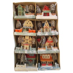
- RARE , LARGE Complete set of 8 Christmas Putz Houses, loofah trees, balconiesBy Leo PutzLocated in Buffalo, NYRare , large, complete set of 8 Christmas PUTZ Houses,, Loofah Trees, balconies, etc.. In original box.Amazing original condition. Stamped on bottom MADE ...Category
Vintage 1920s Japanese Folk Art Models and Miniatures
MaterialsLaminate, Paper
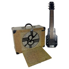
- Rare Art Deco Epiphone Electar Model M Lap Steel Electric Guitar and amp comboBy EpiphoneLocated in Buffalo, NYEpiphone Electar Model M Lap Steel Electric Guitar, with original matching amplifier...black lacquer finish, maple body and etched aluminum top. A very early...Category
Vintage 1930s American Art Deco Musical Instruments
MaterialsAluminum
You May Also Like
- World Relief MapLocated in Antwerp, BELarge world relief map. Measures: Width 232 cm. Height 158 cm.Category
Mid-20th Century German Mid-Century Modern Maps
MaterialsAcrylic
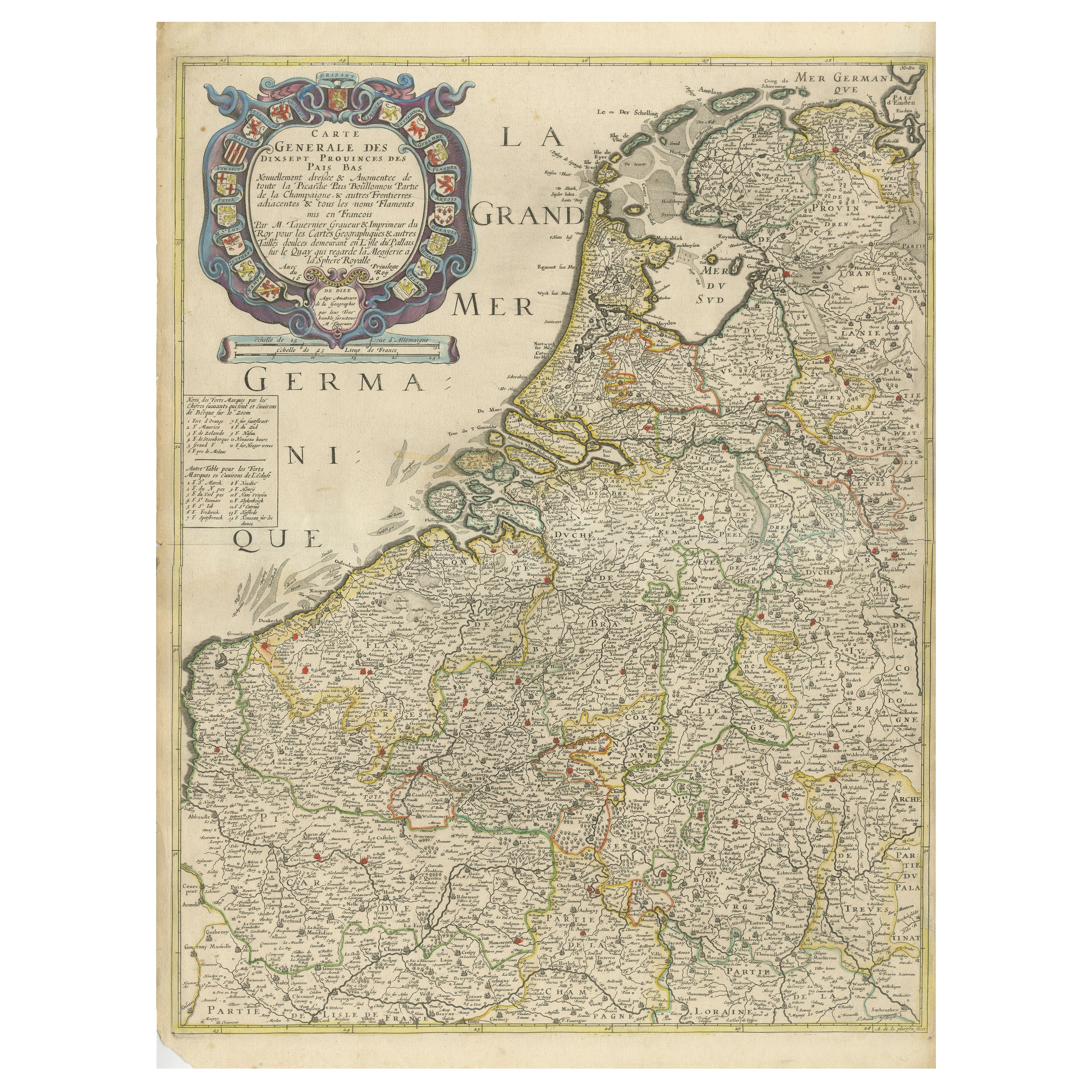
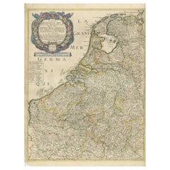
- Rare and Early Map of the Seventeen Provinces, Published in circa 1640Located in Langweer, NLAntique map titled 'Carte Generale des Dixsept Provinces des Pais Bas'. Rare and Early map of the Seventeen Provinces. The Seventeen Provinces were the Imperial states of the Habsbur...Category
Antique Mid-17th Century Maps
MaterialsPaper
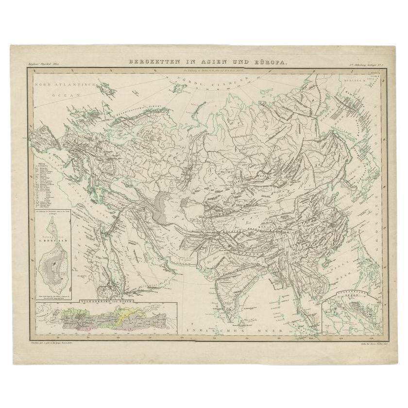
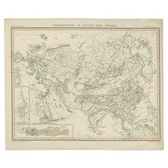
- Antique Map of the Mountain Ranges of Asia and Europe by Berghaus, 1849Located in Langweer, NLAntique map titled 'Bergketten in Asien und Eüropa'. Original antique map showing the mountain ranges in Asia and Europe. In outline color with inset maps of Java, Luzon, and Reguain...Category
Antique 19th Century Maps
MaterialsPaper
- Antique Map of the Mountain Chains of Europe and Asia by Johnston '1850'Located in Langweer, NLAntique map titled 'The Mountain chains of the Europe and Asia '. Original antique map of the mountain chains of Europe and Asia. This map originates from 'The Physical Atlas of Natu...Category
Antique Mid-19th Century Maps
MaterialsPaper
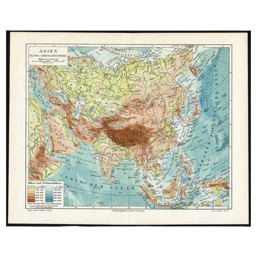
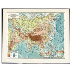
- Antique Map of the Rivers and Mountains in Asia, c.1895By MeyerLocated in Langweer, NLAntique map titled 'Asien. Fluss- und Gebirgssysteme.' Map of Asia, showing river- and mountain systems. This map originates from 'Meyers grosses Konversations-Lexikon.', published in Leipzig and Vienna. Meyers Konversations-Lexikon was a major German encyclopedia that existed in various editions from 1839 until 1984, when it merged with the Brockhaus encyclopedia. Several of the plates were also used in Dutch Encyclopedia's like Winkler Prins...Category
Antique 19th Century Maps
MaterialsPaper
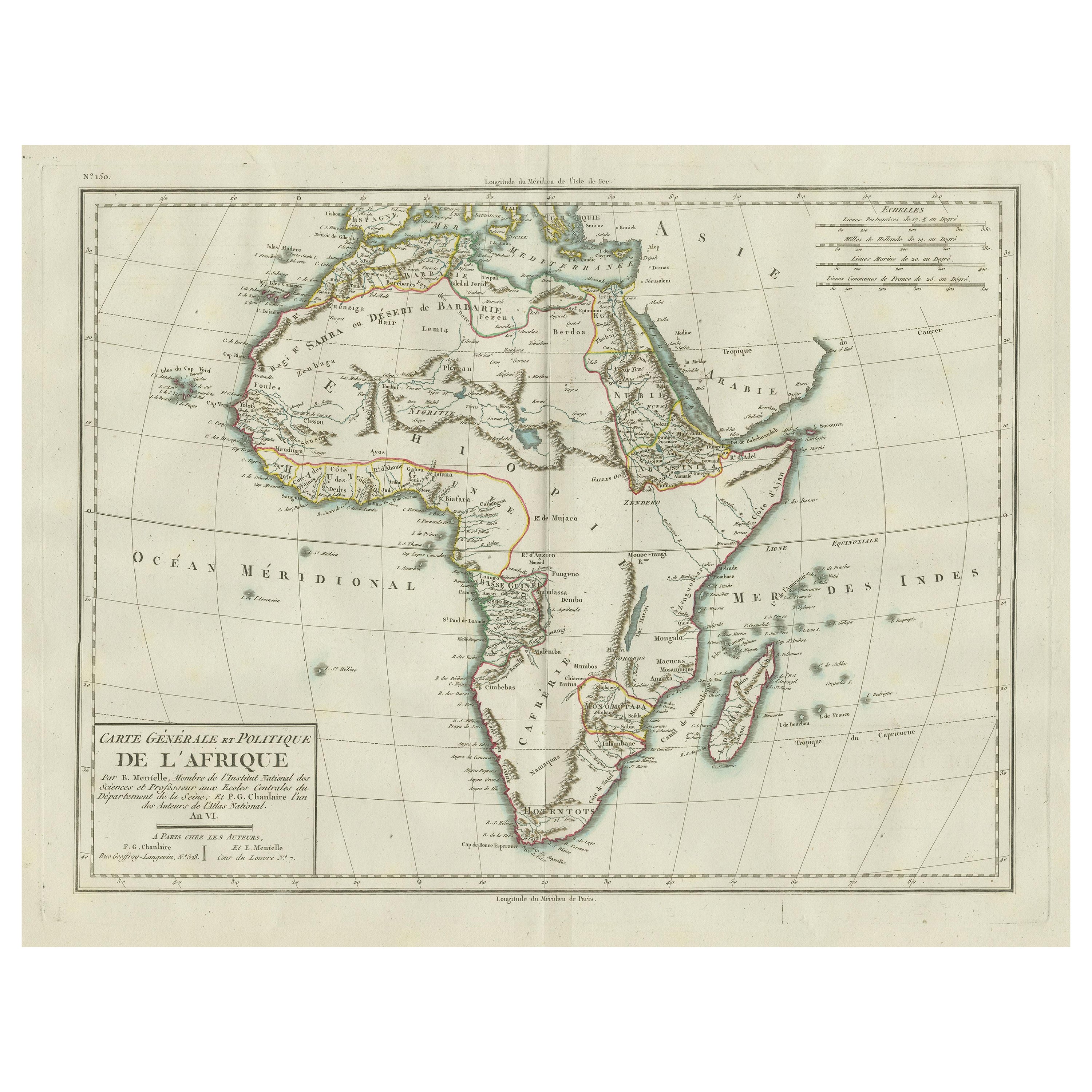
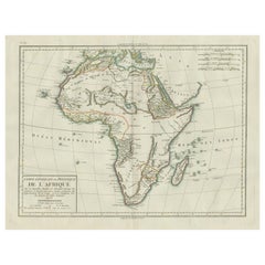
- Antique Map of Africa with Mountain Ranges and other detailsLocated in Langweer, NLAntique map titled 'Carte générale et Politique de l'Afrique'. Original antique map of Africa. Highlights numerous mountain ranges, lakes and rivers, regions, countries and places. P...Category
Antique Late 18th Century Maps
MaterialsPaper


Recently Viewed
View AllMore Ways To Browse
Uruguay Antique Map
Nevada Antique Map
Arizona Map
Map Of Arizona
Panama Antique Map
Antique Iowa Map
Maltese Falcon
Map Of Dc
Map Of Iowa
Map Of Majorca
Metal Knight Statue
Antique Map Ontario
Antique Map Puzzle
Antique Maps Ontario
Antique Puerto Rico Map
Derbyshire Antique Map
Antique Furniture Oklahoma City
Antique Map Bermuda