Items Similar to Cosmgraphy and Astrology, 1686 by Richard Blome from the First Edition

Want more images or videos?
Request additional images or videos from the seller
Cosmgraphy and Astrology, 1686 by Richard Blome from the First Edition
About the Item
Cosmography & Astrology
Large oval engraved plate with inscriptions outlining the various parts of cosmography and astronomy; below, two emblematic figures with scientific instruments either side. Lettered with title, dedication, and various inscriptions. To his Excellency Roger Palmer, Earle of Castelmain and Baron of Limerick in Ireland, Embassador Extraordinary from his majesty King James II to his Holyness Pope Innocent 11th anno dom 1686. This plate is humbly DD by Richard Blome. On paper and retaining its original coloring.
Sheet width 26 ½ cm., 10 ½ in., height 41 ½ cm., 16 ½ in.,
In a part-gilded Sansovino frame, carved with moons and suns
Frame Length 43 cm., 17 in., Height 58 cm., 23 in.
This engraving is an illustration from the first part of the first edition of The Gentleman’s Recreation, published by S. Roycroft in 1686, which was Blome’s best known work outside the realm of cartography and includes some of the earliest published illustrations of a globe and aspects of cosmography & astrology.
Literature: Related to : Engraving 1847,0306.275 in the British Museum, Department of Prints & Drawings, acquired in 1847
The Gentleman's Recreations In Three Parts was comprised of First Part: Introduction to the Liberal Arts, Second Part: Of Horsemanship, Hawking, Hunting.Fowling, Fishing, etc. and Third Part: Laws of the Forest and Game. The first part has 31 plates illustrating liberal arts subjects, 19 of which were oval plates with tables in the center and decorative borders depicting people engaged in activities such as Rhetoric, Logic, Astronomy, Astrology, Cosmography, Navigation and Geography. The second part includes 50 copperplate engravings on horses and different types of hunting activities, including shooting, fishing and falconry.
Richard Blome was among the most active publishers of cartographic and illustrated books in late 17th century London. He was the first publisher in England for 40 years to prepare a new folio world atlas, the first in over 60 years to publish a new set of folio county maps, the first to seriously plan an illustrated description of London, and the first to plan a series of volumes related to the various world continents. In the 1680s, Blome issued some illustrated books, including The Gentleman's Recreation, The History of The Old Testament and a three-volume translation of the works of French philosopher Rene Descartes.
Blome included fortification in his vast compendium of the arts and sciences recommended to the English gentleman, and he had the relevant section written by George Leslie. A variety of alternative methods and systems are presented, indicating different authorities and traditions of practice within the developing domain of fortification.
Signed/Inscribed: 1686.
- Creator:Richard Blome (Maker)
- Dimensions:Height: 16.34 in (41.5 cm)Width: 10.44 in (26.5 cm)Depth: 0.04 in (1 mm)
- Style:Charles II (Of the Period)
- Materials and Techniques:Paper,Glazed
- Place of Origin:
- Period:1680-1689
- Date of Manufacture:1686
- Condition:
- Seller Location:BUNGAY, GB
- Reference Number:1stDibs: LU3867315797902
About the Seller
5.0
Vetted Seller
These experienced sellers undergo a comprehensive evaluation by our team of in-house experts.
Established in 1985
1stDibs seller since 2018
85 sales on 1stDibs
Typical response time: 12 hours
- ShippingRetrieving quote...Ships From: BUNGAY, United Kingdom
- Return PolicyA return for this item may be initiated within 7 days of delivery.
More From This SellerView All
- Map Holy Promise Land Canaan Richard Palmer Richard Blome 1687 Joseph MoxonLocated in BUNGAY, SUFFOLKCanaan comonly called the Holy Land or the Land of Promise, being the Possesion of the Israelites & travelled through by Our Lord & Saviour Iesus Christ and his Apostles. Engraven by Richard Palmer for Richard Blome. 1687 Blome, Richard, 1641-1705. London. 283 x 452 mm. Copperplate. Probably from an English Bible...Category
Antique 17th Century British Baroque Maps
MaterialsPaper
- Road Map Britannia No 32 the Road from London to Barnstable John Ogilby FramedBy John OgilbyLocated in BUNGAY, SUFFOLKA road map from Britannia, by John Ogilby Esq., Cosmographer and Geographick Printer to Charles II. Containing 293 miles. No 32. From Standard in Cornhill London to Andover thence to Amesbury, to Shruton, to Warminster, to Maiden-Bradley, to Bruton, to Weston, to Ascot and to Bridgewater Hand coloured, some foxing and creasing, commensurate with age. Floated in a cream mount with a gilded linear border within a burr walnut, ebonised and gilded frame. Provenance : purchased as pair from a collector with no 15 London to St Davids. Framed as a pair. Measures: Black Linear Border around Map Length 44cm., 17 1/8" Height 36cm., 14". Full Sheet Length 51cm., 20" Height 39cm., 15 1/4" Frame Length 62cm., 24 1/2 " Height 52cm., 20 1/2" Literature: In a remarkable life John Ogilby pursued, several careers, each ending in misfortune, and yet he always emerged undeterred, to carry on. His modern reputation is based on his final career, started in his sixty-sixth year, as a publisher of maps and geographical accounts. Ogilby was born outside Dundee, in 1600, the son of a Scottish gentleman. While he was still a child, the family moved to London. When the elder Ogilby was imprisoned for debt, the young John invested his savings in a lottery, won a minor prize, and settled his father's debts. Unfortunately, not enough money was left to secure John a good apprenticeship; instead, he was apprenticed to a dance master. Ogilby was soon dancing in masques at court but, one day, while executing a particularly ambitious leap, he landed badly. The accident left him with a permanent limp, and ended his dancing career. However, he had come to the attention of Thomas Wentworth, later Earl of Strafford, Charles I's most senior minister. Ever one to exploit his contacts, Ogilby became a dance instructor in Strafford's household. When Strafford was sent to Ireland, Ogilby accompanied him as Deputy-Master of the Kings Revels, and then Master of Revels. In Dublin, he built the New Theatre, in St. Werburgh Street, which prospered at first, but the Irish Rebellion, in 1641, cost Ogilby his fortune, which he estimated at £2,000, and almost his life. After brief service as a soldier, he returned to England, survived shipwreck on the way, and arrived back penniless. On his return, Ogilby turned his attention to the Latin classics, as a translator and publisher. His first faltering attempt, in 1649, was a translation of the works of Virgil, but after his marriage to a wealthy widow the same year, his publishing activities received a considerable boost. One means by which Ogilby financed these volumes was by subscription, securing advance payments from his patrons, in return for including their name and coats-of-arms on the plates of illustrations. Another approach was to secure a patron, preferably in the court circle. Ogilby's first patron was Strafford, who found out too late that all leading ministers are dispensable when Charles I assented to his execution in 1641. As he re-established himself, Ogilby sought a new patron, the King himself. In 1661, Ogilby was approached to write poetry for Charles II's coronation procession; he later published 'The Relation of His Majesties Entertainment Passing Through the City of London', and a much enlarged edition the following year, which included a Fine set of plates depicting the procession. Royal favour was bestowed in 1674 when John Ogilby received the title of 'His Majesty's Cosmographer and Geographick Printer' with a salary of £13.6s.8d per annum. In 1665, Ogilby left London to avoid the Plague then ravaging the capital. The following year, in the Great Fire of London, Ogilby claimed that he lost his entire stock of books valued at some £3,000, as well as his shop and house, leaving him worth just £5. As he sought to restore his fortunes, Ogilby was already looking in new directions. The initial opportunity he seized on was the reconstruction of London's burnt-out centre. He secured appointment as a 'sworn viewer', whose duty was to establish the property boundaries as they existed before the Fire. Ogilby was assisted in the project by his step-grandson, William Morgan...Category
Antique Late 17th Century English Charles II Maps
MaterialsPaper
- Map Hanging Wall County of Devon C&J Greenwood 1827 Exeter Cathedral Lundy IsleLocated in BUNGAY, SUFFOLKC & J GREENWOOD MAP OF THE COUNTY OF DEVON, FROM AN ORIGINAL SURVEY, PUBLISHED 1827, WITH ENGRAVING OF EXETER CATHEDRAL AND MAP OF LUNDY INSET, 6ft 2 ...Category
Antique 1820s English Early Victorian Maps
MaterialsPaper
- Map Holy Land La Terre Sainte Engraved van Loon Published N de Fer 1703 FrenchLocated in BUNGAY, SUFFOLKLa Terre Sainte, The Holy Land, Tiree Des Memoires De M.De.La Rue. Par N. de Fer. Geographe de Sa Majeste Catoliq et de Monseigneur le Dauphin. Avec Privil du Roi 1703 Detailed map of the Holy Land from Nicholas de Fer's L'Atlas Curieux ou le Monde. East is oriented at the top. MAKER Nicolas de Fer 1646-1720 The French cartographer and engraver, Nicolas de Fer, was a master at creating maps that were works of art. The maps that he published were printed during the Baroque period when the decorative arts were characterized by ornate detail. De Fer’s detailed maps and atlases were valued more for their decorative content than their geographical accuracy. Nicolas de Fer was born in 1646. His father, Antoine de Fer, owned a mapmaking firm. At the age of twelve, Nicolas was apprenticed to a Parisian engraver named Louis Spirinx. The family business was starting to decline when his father died in 1673. Nicolas de Fer’s mother, Genevieve, took over the business after the death of her husband. In 1687 the business was passed on to Nicolas and the profits increased after he took over the firm. Nicolas de Fer was a prolific cartographer who produced atlases and hundreds of single maps. He eventually became the official geographer to King Louis XIV of France and King Philip V...Category
Antique Early 1700s French Louis XIV Maps
MaterialsPaper
- Countye of Monmouth, Dated 1610By John SpeedLocated in BUNGAY, SUFFOLKThe countye of Monmouth with the situation of the townshire described Anno, 1610 The reverse with Monmouthshire, Chapter VI and an alphabetical list of towns. In a beautiful Flemish oak polished and gilded frame Cartographer: John Speed...Category
Antique 1610s English Baroque Decorative Art
MaterialsPaper
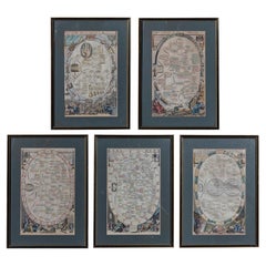
- Copperplate Set 5 Gentlemans Recreation in Two Parts Richard Blome SRoycroft L35Located in BUNGAY, SUFFOLKBLOME, Richard (d. 1705). A set of 5 framed plates from the first part of The gentlemans recreation in two parts : the first being an encyclopedy of the arts and sciences ... the s...Category
Antique 17th Century English Baroque Prints
MaterialsPaper


You May Also Like
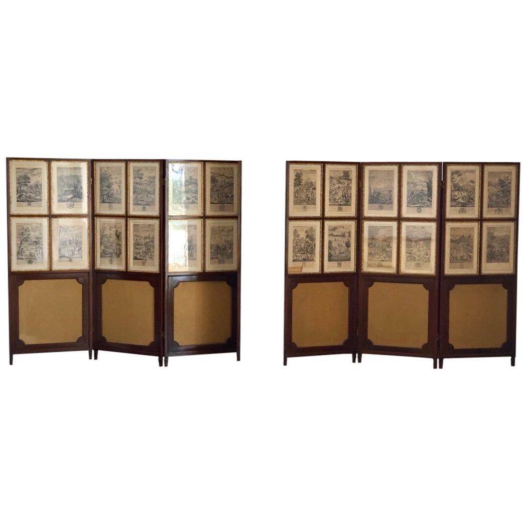
- Set of 24 Engravings by Richard Blome Framed in Pair of Regency ScreensBy Richard BlomeLocated in Charleston, SCRegal set of twenty-four steel engravings of English Hunt Scenes by Richard Blome (1635-1705) framed in a pair of three panel mahogany Regency Screens, 17th century. The etchings are from "BLOME, Richard (1635-1705): The Gentlemans Recreation. ... An Encyclopedia of the Arts and Sciences ... [and] Horsemanship, Hawking, Hunting, Fowling, Fishing and Agriculture. With a Short Treatise of Cock-Fighting. London: S. Roycroft for R. Blome, 1686". Twenty-three of the twenty-four hunt engravings...Category
Antique Late 17th Century English Charles II Drawings
MaterialsUpholstery, Mahogany, Paper
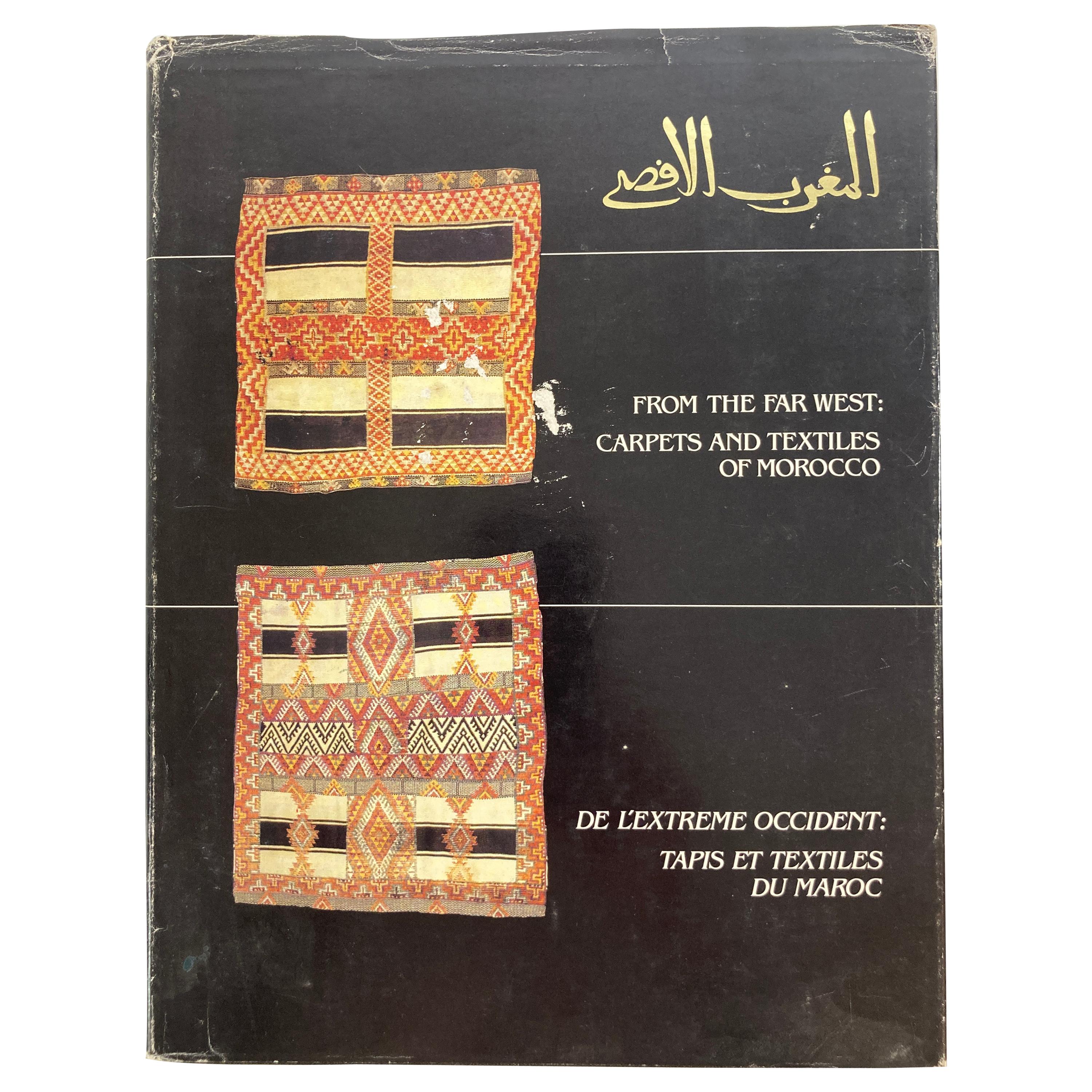
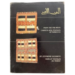
- From the Far West Carpets and Textiles of Morocco Hardcover BookBy Berber Tribes of MoroccoLocated in North Hollywood, CAFrom the Far West Carpets and Textiles of Morocco Fiske, Patricia L. and Pickering, W. Russell and Yohe, Ralph S. in black cloth covered board ...Category
Vintage 1980s Moroccan Modern Books
MaterialsPaper
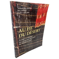
- Over the Desert Au Fil du Désert Textiles from the Nomadic Desert BookLocated in North Hollywood, CAOver the Desert - Tents And Weaving Of Nomadic Pastors. Au fil du de´sert: Tentes et tissages des pasteurs nomades de Me´diterrane´e (French Edition) (French language) Paperback...Category
1990s Moroccan Modern Books
MaterialsPaper
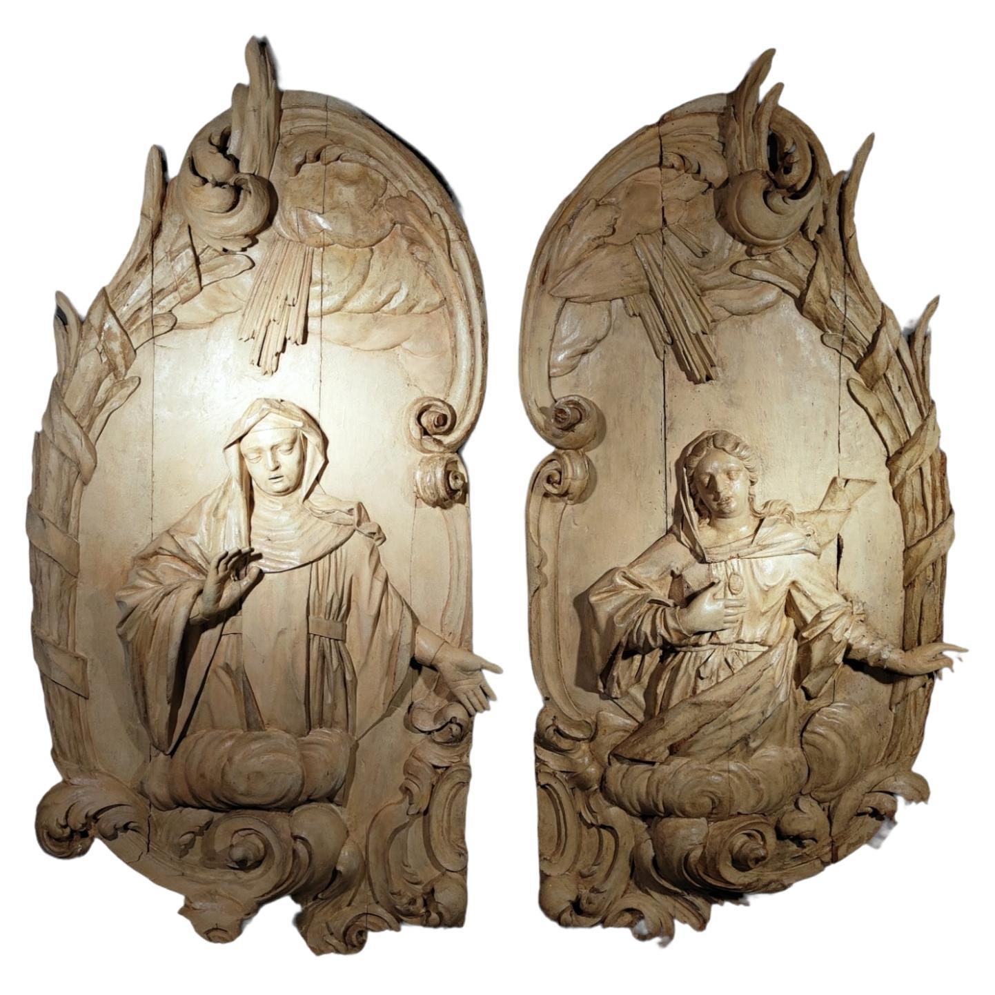
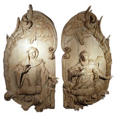
- Pair of Monumental Sculpted Panels from the Eighteenth CenturyLocated in Madrid, ESPAIR OF MONUMENTAL CARVED PANELS FROM THE 18TH CENTURY IMPORTANT SPANISH BAROQUE 18TH CENTURY WOODEN PANELS ATTRIBUTED TO: Luis Bonifás y...Category
Antique 18th Century Decorative Art
MaterialsFruitwood
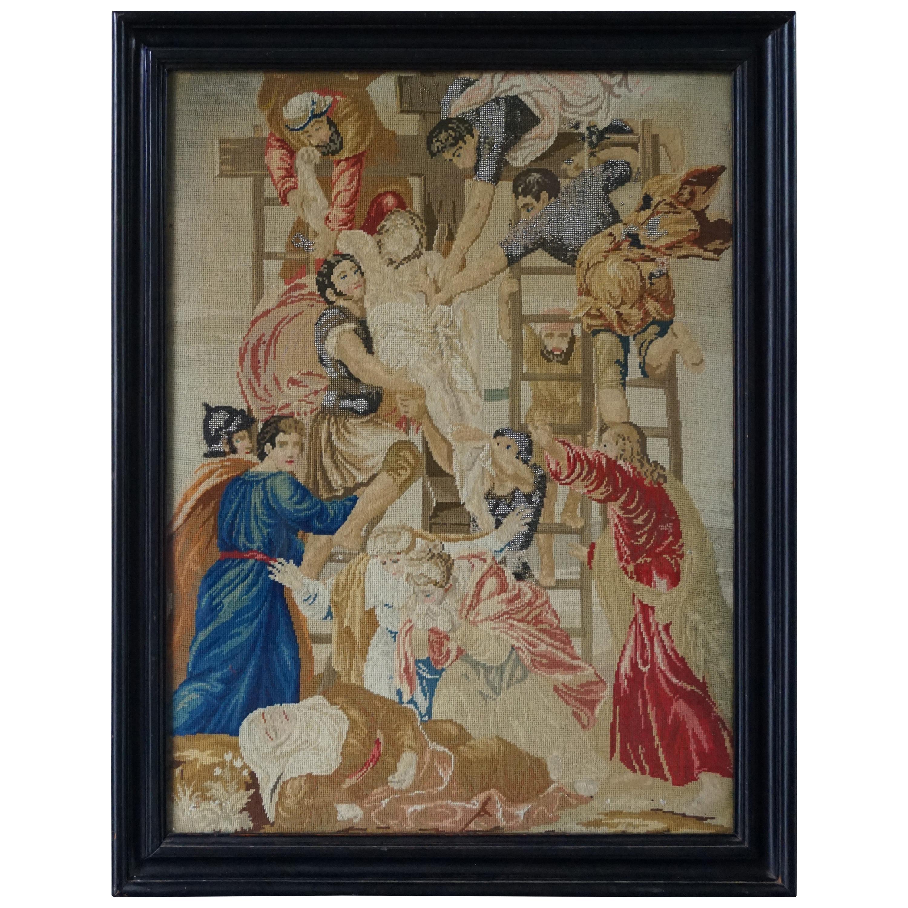
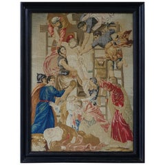
- Stunning Mid-1800s Handcrafted Embroidery of Jesus' Descent from the CrossLocated in Lisse, NLLarge work of religious art, after Daniele da Volterra (1509-1566). This all handcrafted work of art is both stunning and meaningful and the workmanship truly is from a bygone era. ...Category
Antique 19th Century European Renaissance Revival Religious Items
MaterialsMetal
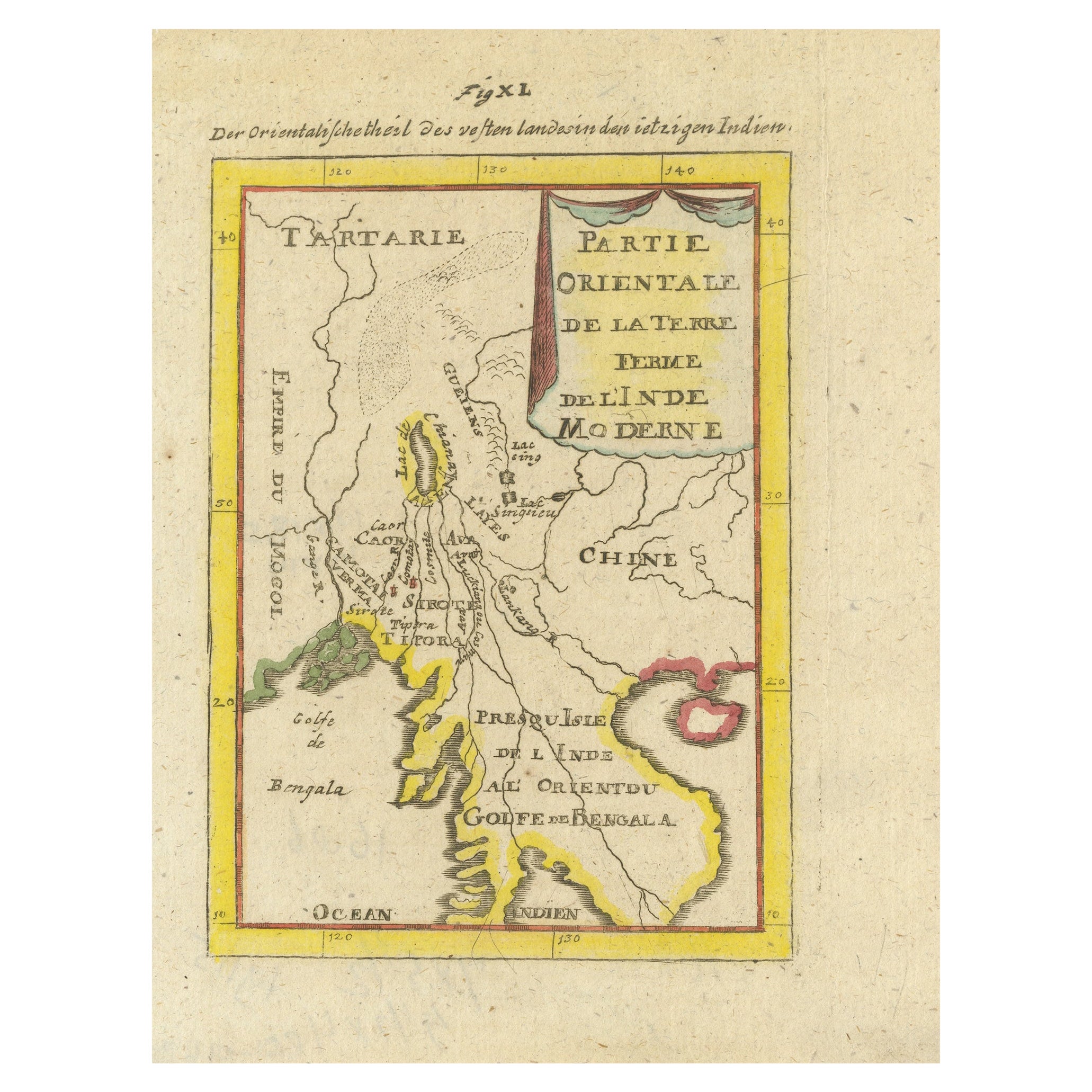
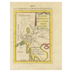
- Antique Map of India and the Gulf of Bengal by Mallet, c.1686Located in Langweer, NLAntique map titled ?Partie Orientale de la Terre Ferme de l'Inde Moderne. Small map of India and the Gulf of Bengal. This map originates from a German edition of 'Description de l' Univers'. Artists and Engravers: Alain Manesson Mallet (1630-1706) was a French cartographer and engineer. He started his career as a soldier in the army of Louis XIV, became a Sergeant-Major in the artillery and an Inspector of Fortifications. He also served under the King of Portugal, before returning to France, and his appointment to the court of Louis XIV. His military engineering and mathematical background led to his position teaching mathematics at court. His 'Description de L'Universe' contains a wide variety of information, including star maps...Category
Antique 17th Century Maps
MaterialsPaper

Recently Viewed
View AllMore Ways To Browse
50s Wall Art
Antique Frames Decorative Arts
Decorative Wall Plate Set
Astrological Signs
Alternative Wall Art
Globe Art Wall
Antique Plates Decorative Arts
Astrology Furniture
17th English Table
James Ii Of England
60s Antique Furniture
Hunting Wall Art
17th Century English Table
King George Ii
17century Carved Table
Antique Table Plans
George Ii Irish
Science Books