Items Similar to Map Holy Promise Land Canaan Richard Palmer Richard Blome 1687 Joseph Moxon


Want more images or videos?
Request additional images or videos from the seller
1 of 7
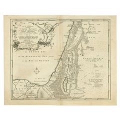
Map Holy Promise Land Canaan Richard Palmer Richard Blome 1687 Joseph Moxon
About the Item
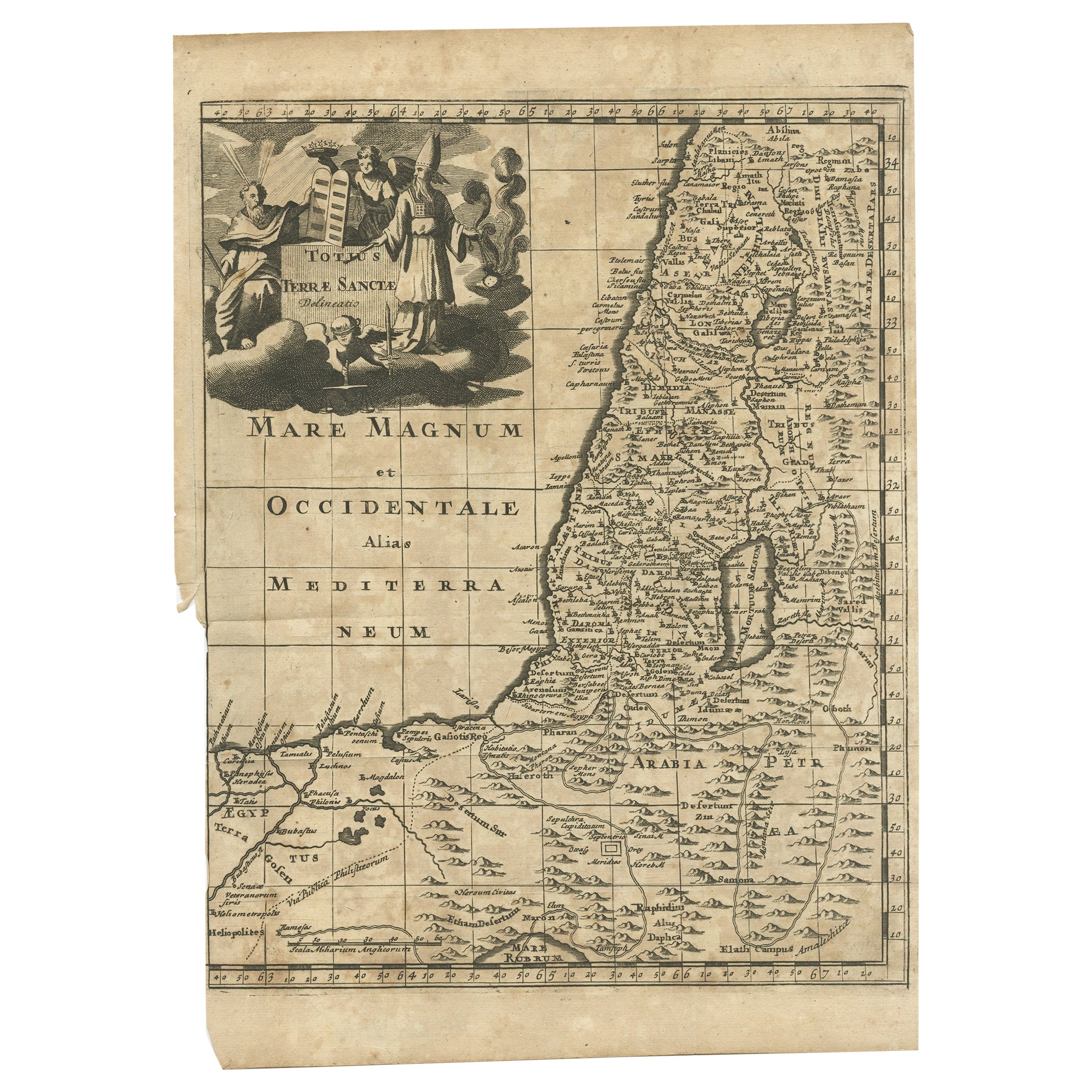
Canaan comonly called the Holy Land or the Land of Promise, being the Possesion of the Israelites & travelled through by Our Lord & Saviour Iesus Christ and his Apostles. Engraven by Richard Palmer for Richard Blome. 1687
Blome, Richard, 1641-1705. London. 283 x 452 mm. Copperplate.
Probably from an English Bible, end of the 17th century.
The map is an exact copy of Nicolaes Visscher's map, with Joseph Moxon's alterations ommiting the title cartouche id at top centre and the decorations.
Bearing Baynton-Williams label, dealer old maps
The map length 46cm., 18" height 26cm., 10 1/4"
In a black and gold frame length 50cm., 19 1/2 " height 31cm., 12 1/2".
- Dimensions:Height: 12.21 in (31 cm)Width: 19.69 in (50 cm)Depth: 0.4 in (1 cm)
- Style:Baroque (Of the Period)
- Materials and Techniques:
- Place of Origin:
- Period:
- Date of Manufacture:1687
- Condition:Wear consistent with age and use.
- Seller Location:BUNGAY, GB
- Reference Number:1stDibs: LU3867332075872
About the Seller
5.0
Vetted Seller
These experienced sellers undergo a comprehensive evaluation by our team of in-house experts.
Established in 1985
1stDibs seller since 2018
85 sales on 1stDibs
Typical response time: 12 hours
- ShippingRetrieving quote...Ships From: BUNGAY, United Kingdom
- Return PolicyA return for this item may be initiated within 7 days of delivery.
More From This SellerView All
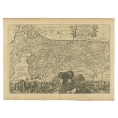
- Map Holy Land La Terre Sainte Engraved van Loon Published N de Fer 1703 FrenchLocated in BUNGAY, SUFFOLKLa Terre Sainte, The Holy Land, Tiree Des Memoires De M.De.La Rue. Par N. de Fer. Geographe de Sa Majeste Catoliq et de Monseigneur le Dauphin. Avec Privil du Roi 1703 Detailed map of the Holy Land from Nicholas de Fer's L'Atlas Curieux ou le Monde. East is oriented at the top. MAKER Nicolas de Fer 1646-1720 The French cartographer and engraver, Nicolas de Fer, was a master at creating maps that were works of art. The maps that he published were printed during the Baroque period when the decorative arts were characterized by ornate detail. De Fer’s detailed maps and atlases were valued more for their decorative content than their geographical accuracy. Nicolas de Fer was born in 1646. His father, Antoine de Fer, owned a mapmaking firm. At the age of twelve, Nicolas was apprenticed to a Parisian engraver named Louis Spirinx. The family business was starting to decline when his father died in 1673. Nicolas de Fer’s mother, Genevieve, took over the business after the death of her husband. In 1687 the business was passed on to Nicolas and the profits increased after he took over the firm. Nicolas de Fer was a prolific cartographer who produced atlases and hundreds of single maps. He eventually became the official geographer to King Louis XIV of France and King Philip V...Category
Antique Early 1700s French Louis XIV Maps
MaterialsPaper
- Cosmgraphy and Astrology, 1686 by Richard Blome from the First EditionBy Richard BlomeLocated in BUNGAY, SUFFOLKCosmography & Astrology Large oval engraved plate with inscriptions outlining the various parts of cosmography and astronomy; below, two emblematic figures with scientific instruments either side. Lettered with title, dedication, and various inscriptions. To his Excellency Roger Palmer, Earle of Castelmain and Baron of Limerick in Ireland, Embassador Extraordinary from his majesty King James II to his Holyness Pope Innocent 11th anno dom 1686. This plate is humbly DD by Richard Blome. On paper and retaining its original coloring. Sheet width 26 ½ cm., 10 ½ in., height 41 ½ cm., 16 ½ in., In a part-gilded Sansovino frame...Category
Antique 1680s English Charles II Decorative Art
MaterialsPaper
- Map Shropshire Joseph Ellis Robert Sayer Carington Bowles FramedLocated in BUNGAY, SUFFOLKA modern map of Shropshire Drawn from the latest surveys corrected and improved by the best authorities. Artist Joseph Ellis sculptor. Joseph Ellis was an engraver and publisher from Clerkenwell in London and was apprenticed to Richard William Seale in 1749. He is best know to county map collectors for The New English Atlas published in 1765 which was later reissued as Ellis's English Atlas in 1766, 1768 1777, 1786, 1790 and 1796. Maker carington bowles 1724 - 1793. Carington Bowles worked in London as a publisher in partnership with his father John Bowles from about 1752 until 1763. Carington Bowles worked as a publisher in partnership with his father John Bowles from about 1752 until 1763 before taking over his uncle's business. His address was 69 St. Pauls Church Yard, London. He worked with a number of well known cartographers of the day including Emanuel Bowen, Thomas Kitchin, Robert Sayer...Category
Antique 18th Century English Georgian Maps
MaterialsPaper
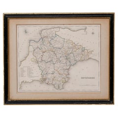
- Map Devonshire Richard Creighton J&C Walker Sculp Samuel LewisLocated in BUNGAY, SUFFOLKDevonshire drawn by Richard Creighton with reference to the Unions Artist Richard Creighton Engraved by J&C Walker Sculp Published in Samuel Lewis Topographical Dictionary 1831, a...Category
Antique 19th Century English Victorian Maps
MaterialsPaper
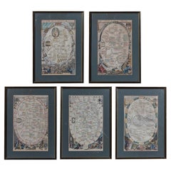
- Copperplate Set 5 Gentlemans Recreation in Two Parts Richard Blome SRoycroft L35Located in BUNGAY, SUFFOLKBLOME, Richard (d. 1705). A set of 5 framed plates from the first part of The gentlemans recreation in two parts : the first being an encyclopedy of the arts and sciences ... the s...Category
Antique 17th Century English Baroque Prints
MaterialsPaper
- Map SussexLocated in BUNGAY, SUFFOLKMap of Sussex with explanation Maker unknown.Category
Antique 19th Century English Victorian Maps
MaterialsPaper


You May Also Like
- Antique Map of the Holy Land, c.1717Located in Langweer, NLAntique map Israel titled 'Tabula Geographica Terrae Sanctae'. Rare edition made after a map of the Holy Land by J. Bonfrerius. The map is oriented ...Category
Antique 18th Century Maps
MaterialsPaper
- Antique Map of the Holy Land, c.1710Located in Langweer, NLAntique map titled 'Totius Terrae Sanctae Delineatio'. Map of the Holy Land extending to Egypt and showing the route of the Children of Israel in their e...Category
Antique 18th Century Maps
MaterialsPaper
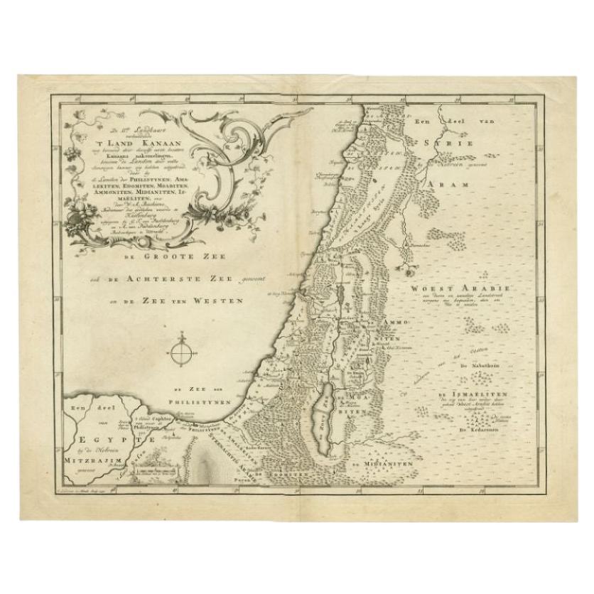
- Antique Map of the Biblical Land of Canaan by Lindeman, c.1758Located in Langweer, NLAntique map titled 'De IIde Landkaart verbeeldende t'Land Kanaan nog bewoond door deszelfs eerste bezitters (..).' - Map of the biblical Land of Canaan. With large title cartouche, c...Category
Antique 18th Century Maps
MaterialsPaper
- Antique Map of the Holy Land by Danckerts, c.1710Located in Langweer, NLAntique map titled 'Afbeeldinge van de Veertich-Iaarige Reyse der Kinderen Israëls uyt Egypten door de Roode Zee en de Woestyne tot in 't Beloofde Landt Canaan'. Map of the Holy Land...Category
Antique 18th Century Maps
MaterialsPaper
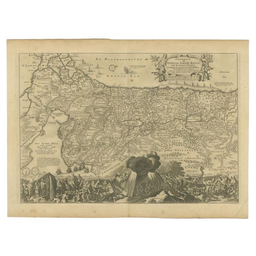
- Antique Map of the Holy Land by Keur, 1748Located in Langweer, NLAntique biblical map titled 'Perigrinatie ofte veertigh-Iarige Reyse der Kinderen Israels uyt Egypten door de Roode Zee ende de Woestyne tot in 't Beloof...Category
Antique 18th Century Maps
MaterialsPaper
- Antique Map of the Holy Land by Keur, 1748Located in Langweer, NLAntique Map Holy Land titled 'De Gelegentheyd van t'Paradys ende t'Landt Canaan, Mitsgaders d'eerst bewoonde Landen der Patriarchen'. Includes five decorative vignettes, including No...Category
Antique 18th Century Maps
MaterialsPaper


Recently Viewed
View AllMore Ways To Browse
Antique Id
United Kingdom Dealers
Baroque Cartouche
Antique English Bible
Antique Holy Bible
English Bible
The Holy Bible
Gold Palmer
Bible Maps
12 Apostles
Holy English Bible
Antique Map Of New York City
Antique Maps Of New York City
Antique Blackwood Furniture
Antique Linen Map
Map Of Boston
Boston Map
Antique Furniture Malaysia