Items Similar to Mid-19th Century American Stationary with Manuscript Letter, Signed 1854

Want more images or videos?
Request additional images or videos from the seller
1 of 6
Mid-19th Century American Stationary with Manuscript Letter, Signed 1854
About the Item
American stationery with in the top the following text printed:
E pluribus unum – Latin for "Out of many, one" (also translated as "One out of many" or "One from many") – is a traditional motto of the United States, appearing on the Great Seal along with Annuit cœptis (Latin for "he approves the undertaking [lit. 'things undertaken']") and Novus ordo seclorum (Latin for "New order of the ages"); its inclusion on the seal was approved by an Act of Congress in 1782. While its status as national motto was for many years unofficial, E pluribus unum was still considered the de facto motto of the United States from its early history. Eventually, the United States Congress passed an act (H. J. Resolution 396), adopting "In God We Trust" as the official motto in 1956.
The thirteen letters of E PLURIBUS UNUM makes its use symbolic of the thirteen original states like the thirteen stripes on the US flag. The meaning of the phrase originates from the concept that out of the union of the original Thirteen Colonies emerged a new single nation. It is emblazoned across the scroll and clenched in the eagle's beak on the Great Seal of the United States. (Source: wikipedia)
Text below the portraits: "The Presidents of our Great Republic."
Letter paper with hand-colored engraving showing the portraits of the 14 presidents of the USA from George Washington up to Franklin Pierce (president "from March 1853").
Publisher was Charles Magnus in New York.,
Interesting type of stationery, of which a few variants are known: it was apparently updated once a new President was elected. The central President was the then sitting President (or in a variant George Washington), surrounded by the portraits of his predecessors (or following Presidents). Other copies traced have the central portrait of Abraham Lincoln (without beard) and a variant of the present Franklin Pierce's portrait showing him looking to the left (in our copy looking to the right). The publisher of the stationery, Charles Magnus was active between 1850-1899.
Condition: 1 folded leaf, with 3-page manuscript letter in pen and ink in German signed by "F. Rosenthal", dated "New York den 28ten Mai 1856". - Splitting (and partly strengthened w. paper tape) on folds.
- Dimensions:Height: 11.03 in (28 cm)Width: 8.86 in (22.5 cm)Depth: 0 in (0.02 mm)
- Materials and Techniques:
- Period:
- Date of Manufacture:circa 1850
- Condition:Repaired: A few remains of tape on inner folding lines. Condition: 1 folded leaf, with 3-page manuscript letter in pen and ink in German signed by "F. Rosenthal", dated "New York den 28ten Mai 1856". - Splitting (and partly strengthened w. paper tape) on folds.
- Seller Location:Langweer, NL
- Reference Number:
About the Seller
5.0
Platinum Seller
These expertly vetted sellers are 1stDibs' most experienced sellers and are rated highest by our customers.
Established in 2009
1stDibs seller since 2017
1,933 sales on 1stDibs
Typical response time: <1 hour
- ShippingRetrieving quote...Ships From: Langweer, Netherlands
- Return PolicyA return for this item may be initiated within 14 days of delivery.
More From This SellerView All
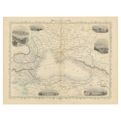
- Mid 19th Century Map of the Black Sea with Decorative Vignettes, 1851Located in Langweer, NLMap of the Black Sea and contingent lands, including Turkey, Russia, Georgia, Azerbaijan, Bulgaria, Crimea and Armenia, with decorative vignettes views of Sebastopol, Varna, Odessa, Sinope, Constantinople and Silistria. Fine antique map...Category
Antique Mid-19th Century Maps
MaterialsPaper
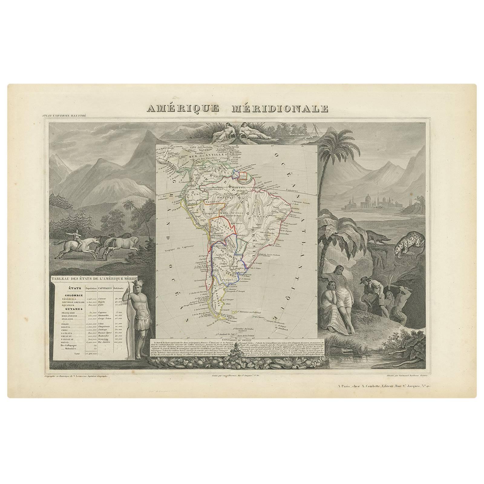
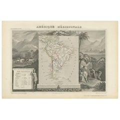
- Antique Map of South America by V. Levasseur, 1854By Victor LevasseurLocated in Langweer, NLAntique map titled 'Amérique Méridionale'. Map shows South America, beautiful surrounded by typical scenes of natives and their life. Depicting Colombia, Brazil, Chile, Bolivia and m...Category
Antique Mid-19th Century Maps
MaterialsPaper
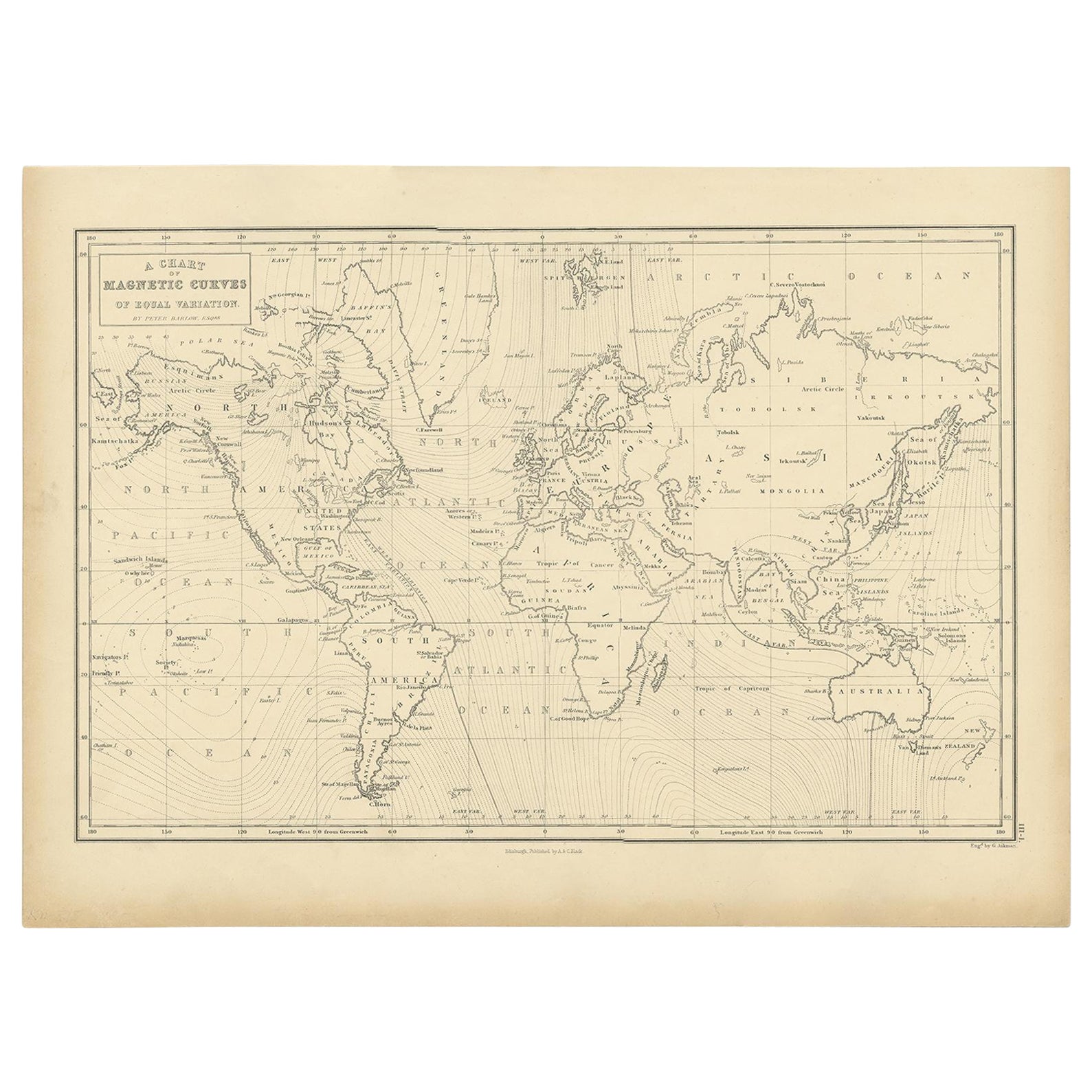
- Antique Chart with Isomagnetic Lines by Black, 1854Located in Langweer, NLAntique map titled 'A Chart of Magnetic Curves of Equal Variation'. Chart with isomagnetic lines on continents, except for North America. This map orginates from 'General Atlas Of Th...Category
Antique 19th Century Prints
MaterialsPaper
- Antique Map of Greece with an Inset Map of Corfu, 1854Located in Langweer, NLAntique map titled 'Hellas or Greece'. Old map of Greece with an inset map of Corfu. This map orginates from 'General Atlas Of The World: Containing Upwards Of Seventy Maps (..)' by ...Category
Antique 19th Century Maps
MaterialsPaper
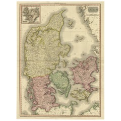
- 19th Century Large Original Antique Map of Denmark by J. Pinkerton, 1812By PinkertonLocated in Langweer, NLHighly detailed map of Denmark. One of the best large format English atlas maps of the period. Pinkerton's maps reflect the fine copperplate engraving work being done in the Britain...Category
Antique Early 19th Century Maps
MaterialsPaper
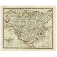
- Old Map of Holstein with the Imperial Towns Hamburg & Lubeck, Germany, 1854Located in Langweer, NLAntique map titled 'Map of the Duchy of Holstein with the territories of the Imperial Towns Hamburg & Lubeck (..) Based on a map by Fischer.' Map of the Duchy of Holstein. From Jam...Category
Antique 1850s Maps
MaterialsPaper

You May Also Like
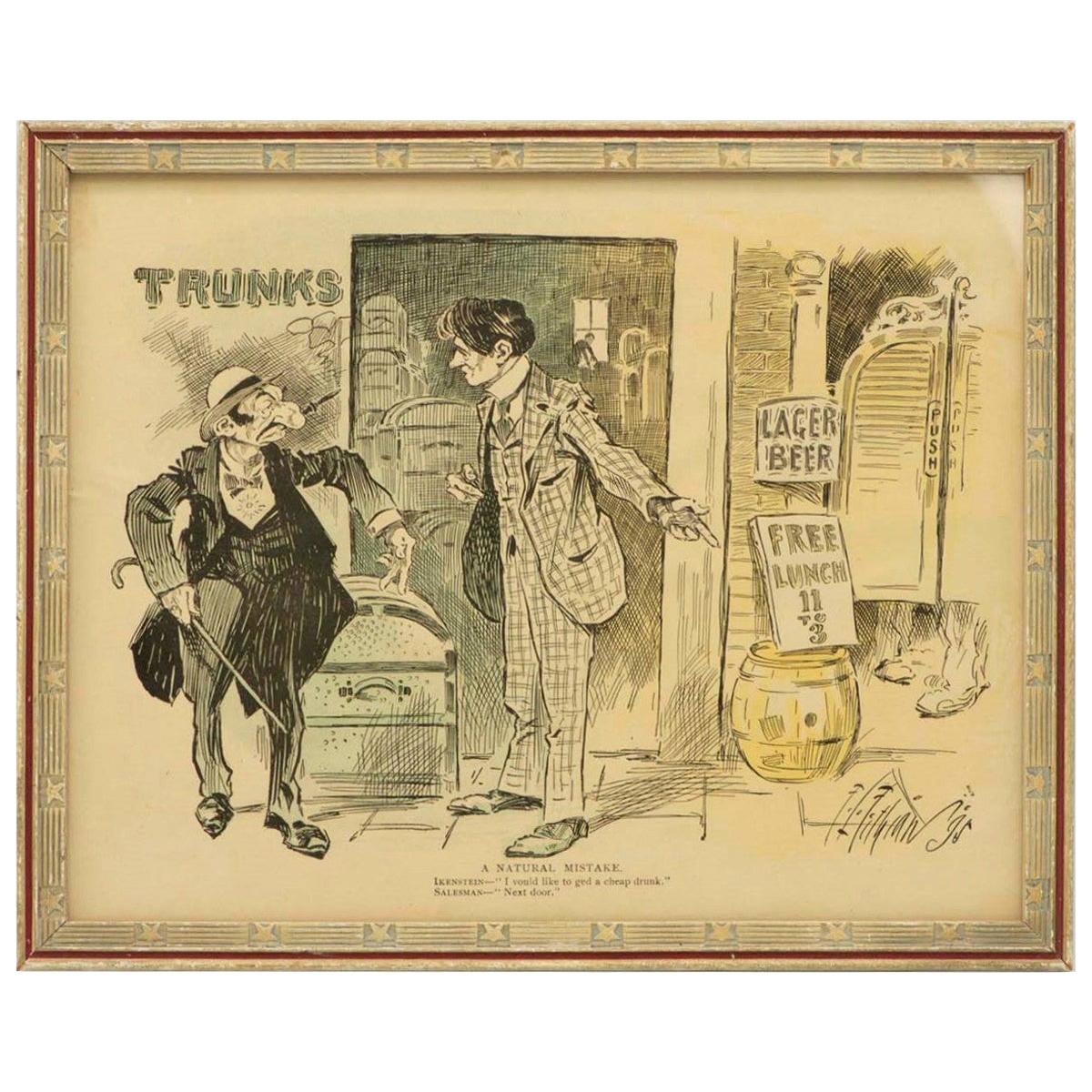
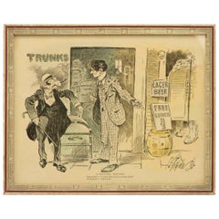
- Late 19th Century American Jewish Themed CaricatureLocated in New York, NYAmerican cartoon, USA, 1895. Caption reads: 'A Natural Mistake. Ikenstein: "I vould like to ged a cheap drunk." Salesman: "Next door.'" The cartoon is framed with American frame of...Category
Antique 1890s American Prints
MaterialsPaper
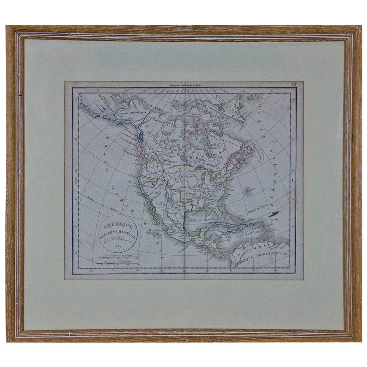
- America "Amérique Septentrionale": A 19th Century French Map by DelamarcheBy Maison Delamarche 1Located in Alamo, CAThis framed mid 19th century map of North America entitled "Amérique Septentrionale" by Felix Delamarche was published in Paris in 1854 by Quay de l'Horloge du Palais, avec les Carte...Category
Antique Mid-19th Century American Other Maps
MaterialsPaper
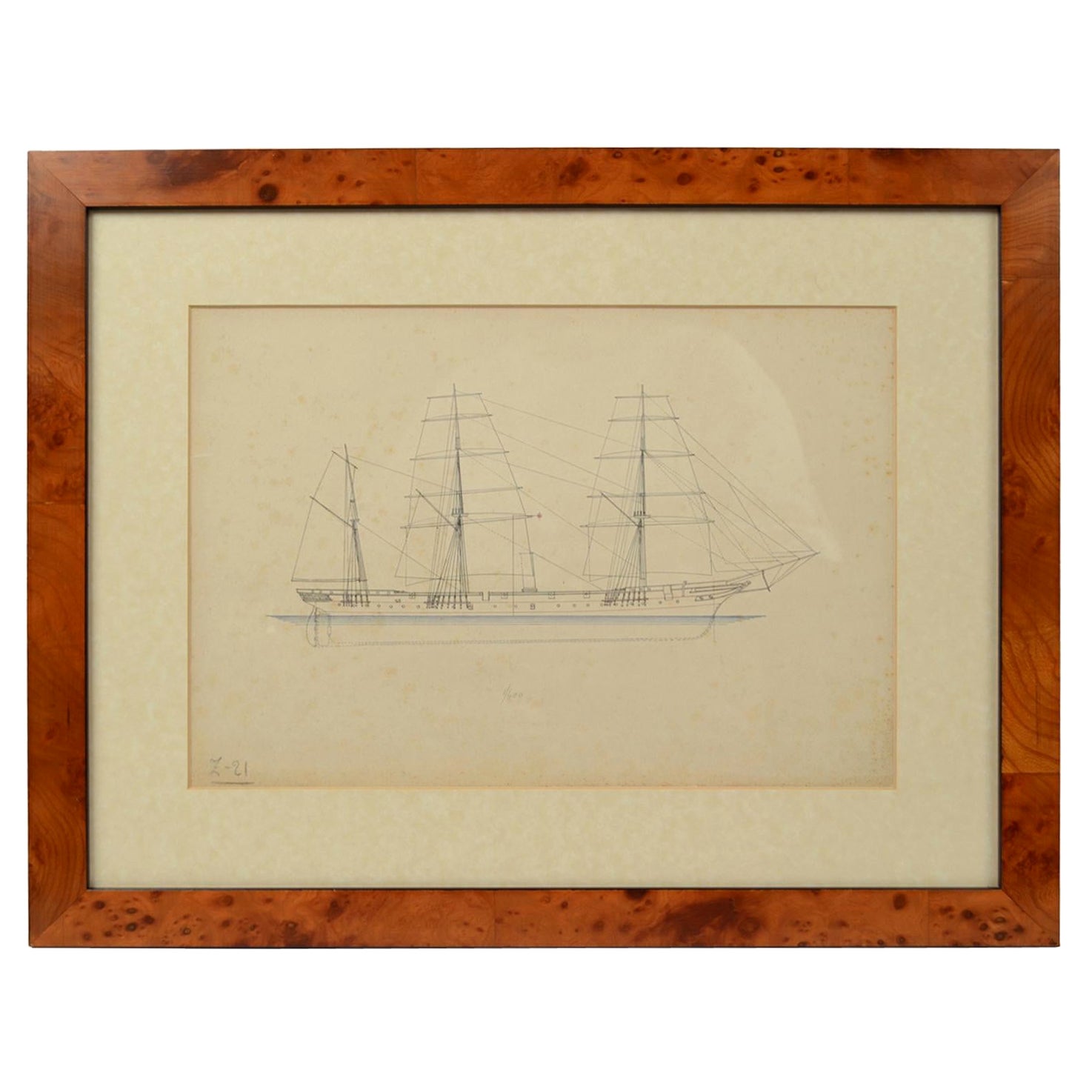
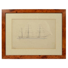
- Print No. 1 of 400 Depicting a Nautical Schooner Made in the Mid-19th CenturyLocated in Milan, ITPrint depicting a schooner, no. 1 of 400 copies signed Z21, made in the mid-19th century. Non-coeval briarwood frame; measures with frame 50 x 40 cm.Category
Antique 1850s British Nautical Objects
MaterialsPaper
- Louisiana: A Framed 19th Century Map by O. W. GrayBy Gray and CoLocated in Alamo, CAThis framed 19th century map of the Louisiana territory was published in "Gray's Atlas of the United States with General Maps of the World, accompanied by Descriptions Geographical, Historical, Scientific and Statistica" published in 1873 in Philadelphia by O.W. Gray and Son and Stedman, Brown and Lyon. It is a highly detailed map of Louisiana...Category
Antique Mid-19th Century American Other Maps
MaterialsPaper
- 19th Century French Émile Deyrolle Anatomical Lithograph PosterLocated in London, GBÉmile Deyrolle Anatomical poster A wonderfully rare and decorative curio medical French (Paris) original lithograph on board anatomical poster in ...Category
Antique 1880s French Early Victorian Scientific Instruments
MaterialsPaper
- Albrecht Dürer "The Small Horse, " 19th Century Copper Plate EngravingBy Albrecht DürerLocated in Barcelona, ES"The Small Horse" copper plate engraving by Albrecht Dürer, circa 1505. This is a 19th century engraving, printed in black on laid paper, framed by a beautiful gilt and ebonized carv...Category
Antique Late 19th Century French Renaissance Prints
MaterialsWood, Paper


Recently Viewed
View AllMore Ways To Browse
Antique Stationary
President Lincoln
Antique Furniture Lincoln
Antique Stationery
Eagle Flag
Abraham Lincoln Portrait
Eagle And Flag
Eagle With Flag
Antique George Washington Print
Antique George Washington Prints
Stationary Paper
Antique Us Flags
Antique Us Flag
Folded American Flag
1850 Portrait American
Abraham Lincoln Print
Lincoln Flag
Antique Letter Seals