Map Of Mexican California
1
to
9
70
14
37
26
22
14
13
11
11
10
8
6
6
5
4
4
4
3
3
3
3
3
2
2
2
1
1
1
1
1
1
1
1
1
1
1
1
1
1
1
7
6
3
3
3
Sort By
Original Antique Map of the Western Part of NEW MEXICO & CALIFORNIA
Located in Langweer, NL
Title: "Map of the Western Part of NEW MEXICO and CALIFORNIA According to the Latest Discoveries by
Category
Antique 1760s Maps
Materials
Paper
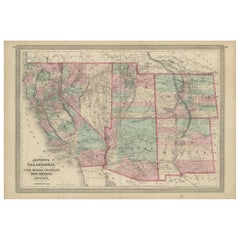
Antique Map of California, Utah, Nevada, Colorado, New Mexico & Arizona '1872'
Located in Langweer, NL
Antique map titled 'Johnson's California (..)'. Original map of California, Utah, Nevada, Colorado
Category
Antique Late 19th Century Maps
Materials
Paper
H 18.12 in W 26.38 in D 0.02 in
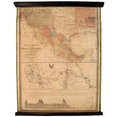
1847 Antique Map of Mexico, Texas and California by Samuel Augustus Mitchell
By Samuel Augustus Mitchell 1
Located in Colorado Springs, CO
& Upper California, an important map showing the progress of the Mexican-American War. Published in 1847
Category
Antique 1840s American Maps
Materials
Paper
H 32 in W 23.63 in D 0.5 in
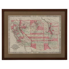
1865 "Johnson's California, Utah, Nevada, Colorado, New Mexico, Arizona" Map
Located in Colorado Springs, CO
, New Mexico, and Arizona” map. First published in 1864, this map was issued as pages 66 and 67 in the
Category
Antique Mid-19th Century Maps
Materials
Paper
H 22.5 in W 30.5 in D 0.75 in
California, Alaska and Mexico: 18th Century Hand-Colored Map by de Vaugondy
By Didier Robert de Vaugondy
Located in Alamo, CA
cartes publiees au commencement de 17e Siecle" (Map of California and the Northwestern Countries
Category
Antique 1770s French Maps
Materials
Paper
H 13.75 in W 16.63 in D 0.13 in
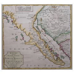
Antique Map of Baja California and parts of Alta California, Arizona and Sonora
Located in Langweer, NL
Antique map titled 'Kaart van het Westelyk Gedeelte van Nieuw Mexico en van California'. Beautiful
Category
Antique Mid-18th Century Maps
Materials
Paper
Free Shipping
H 14.1 in W 14.97 in D 0.02 in
1830 Mexico and United States Framed Map
Located in Stamford, CT
Map of North America published circa 1830. Map shows United States into Canada. Mexico extending
Category
Antique 1830s American American Classical Maps
Materials
Glass, Wood, Paper
Antique Map of Part of the United States Including Lower California & Arizona
Located in Langweer, NL
Antique map of part of the United States of America including Lower California, Arizona and part of
Category
Antique Late 19th Century Maps
Materials
Paper
H 15.08 in W 18.75 in D 0.02 in
1847 Ornamental Map of the United States & Mexico by H. Phelps
Located in Colorado Springs, CO
States & Mexico" by Humphrey Phelps. The map was issued as an act of Congress by Phelps on Fulton Street
Category
Antique 1840s American Maps
Materials
Paper
Antique Map of the Pacific Ocean by Anson, 1765
Located in Langweer, NL
islands and much of the Mexican and California coast. Numerous important destinations along the California
Category
Antique 18th Century Maps
Materials
Paper
Antique Map of The United States of North America, Pacific States, 1882
Located in Langweer, NL
Mexico would remain territories until 1912.
6. **Natural Features**: The map would showcase significant
Category
Antique 1880s Maps
Materials
Paper
No Reserve
H 14.97 in W 11.03 in D 0 in
America "Amérique Septentrionale": A 19th Century French Map by Delamarche
By Maison Delamarche 1
Located in Alamo, CA
. California and the southwestern states are still part of Mexico at the time this map was published.
The map
Category
Antique Mid-19th Century American Other Maps
Materials
Paper
H 20 in W 22.63 in D 0.88 in
1879 "United States of America, Western Part" by O. J. Stuart
Located in Colorado Springs, CO
This colorful original map, titled “United States of America, Western Part,” was issued in Volume
Category
Antique 1870s American Maps
Materials
Paper
Antique Chart of the Mid-Pacific Ocean by Anson, 'c.1784'
Located in Langweer, NL
the coasts of California and Mexico to the east and the Philippines and Japan to the west. A few
Category
Antique Late 18th Century Maps
Materials
Paper
1889 "The Pacific States and Territories"
Located in Colorado Springs, CO
Territories.” The vertical map depicts the Western states at the time: Washington, Oregon, California, Montana
Category
Antique 1880s American Maps
Materials
Paper
Original 'Map of the United States as Californians See It' vintage map poster
Located in Spokane, WA
Original vintage poster: "Map of the United States as Californians See It". 1947, artist: Oren
Category
1940s American Modern Landscape Prints
Materials
Offset
H 16.5 in W 20.5 in D 0.04 in
Original Southern California Home Federal Fun Map vintage poster
Located in Spokane, WA
Original California Fun Map vintage poster from 1973. Archival linen backed in fine condition
Category
1970s American Modern Landscape Prints
Materials
Offset
H 38 in W 24.5 in D 0.05 in
'Trinity', Chicano Artist, Museum of Contemporary Art, Los Angeles, Mexico City
Located in Santa Cruz, CA
. Zenteno has exhibited both pictorial work and video-art with success in Southern California and Mexico
Category
1990s Figurative Paintings
Materials
Canvas, Ink, Acrylic
Geobond - Colorful Authentic Urban Map Currency Painting
By Fabio Coruzzi
Located in Los Angeles, CA
Foggia, Italy in 1975, and now resides in Southern California, USA. Remarking on his work in conjunction
Category
21st Century and Contemporary Pop Art Figurative Paintings
Materials
Canvas, Oil Pastel, Mixed Media, Acrylic, Ink, Graphite
Broke - Mixed Media Credit Card Map Original Artwork
By Fabio Coruzzi
Located in Los Angeles, CA
1975, and now resides in Southern California, USA. Remarking on his work in conjunction with his
Category
21st Century and Contemporary Pop Art Mixed Media
Materials
Mixed Media, Spray Paint, Panel
Map Tabula Asiae IX Pakistan Afghanistan Iran Indian Ocean
Located in Florham Park, NJ
, Brazil, Mexico, Baja California, the Gulf Coast of Florida. New England with parts of Labrador, Africa
Category
16th Century Realist Prints and Multiples
Materials
Copper
H 16.75 in W 19 in D 2 in
Broke 2 - Mixed Media Credit Card Map Original Artwork
By Fabio Coruzzi
Located in Los Angeles, CA
1975, and now resides in Southern California, USA. Remarking on his work in conjunction with his
Category
21st Century and Contemporary Pop Art Mixed Media
Materials
Mixed Media, Spray Paint, Panel
"Cenizo" San Carlos Mexico area Burros Mts. in the Distance
By Dwight Holmes
Located in San Antonio, TX
, East and West Coasts; throughout Texas; in Mexico, New Mexico, Arizona, Utah, Colorado, California
Category
1980s Impressionist Landscape Paintings
Materials
Oil
H 31 in W 43 in D 4 in
North America: A Framed Hand-colored 19th Century German Map by Adolph Stieler
By Adolf Stieler
Located in Alamo, CA
and The Osage District. The map does include Canada, Mexico, Central America, Cuba, Jamaica, Haiti
Category
1830s Landscape Prints
Materials
Engraving
H 19.5 in W 22 in D 0.88 in
"BLUEBONNET" #10 OF COMFORT TEXAS Volkenburg Mountain
By Dwight Holmes
Located in San Antonio, TX
Mexico, New Mexico, Arizona, Utah, Colorado, California, Tennessee, Georgia, in the Great Smokies
Category
1980s American Impressionist Landscape Paintings
Materials
Oil
'Lieutenant Crovers Despatch – Return of Governor Stevens to Fort Benton'
By John Mix Stanley
Located in Milwaukee, WI
: to produce topographical maps, to document flora and fauna, and to document natural resources to
Category
1850s Romantic Landscape Prints
Materials
Lithograph
'Distribution of Goods to the Assiniboines' original John Mix Stanley lithograph
By John Mix Stanley
Located in Milwaukee, WI
Mexican-American War, he joined Colonel Stephen Watts Kearney's expedition to California and painted
Category
1850s Romantic Landscape Prints
Materials
Lithograph
'Distribution of Goods to the Gros Ventres' lithograph by John Mix Stanley
By John Mix Stanley
Located in Milwaukee, WI
the Mexican-American War, he joined Colonel Stephen Watts Kearney's expedition to California and
Category
1850s Romantic Landscape Prints
Materials
Lithograph
Cindy Kane 1985 Original Painting on Plywood
By Cindy Kane
Located in Larchmont, NY
paintings of maps, birds, toys, and artifacts from nature, often collaging bits of newspaper headlines
Category
1980s American Modern Abstract Paintings
Materials
Plywood, Oil
"'BLUEBONNET FIELDS" TEXAS HILL COUNTRY FRAMED 29.5 X 41.5
By Dwight Holmes
Located in San Antonio, TX
Mexico, New Mexico, Arizona, Utah, Colorado, California, Tennessee, Georgia, in the Great Smokies
Category
1970s Impressionist Landscape Paintings
Materials
Oil
H 24 in W 36 in D 3 in
English Pocket Globe, London, Circa 1775-1798
By Herman Moll
Located in Milano, IT
region in his 1727 map. (Encyclopaedia Britannica, ed. 1902, under "States of Central Africa"); Tartary
Category
Antique Late 18th Century English George III Globes
Materials
Shagreen, Paper
Wonderful and extremely rare Dutch pocketglobe
By Dementz Family DEUR Art Company
Located in ZWIJNDRECHT, NL
Mexico’. California is still seen as a separate island off the western coast. Australia (“Hollandia Nova
Category
Antique Early 18th Century Dutch Dutch Colonial Globes
Materials
Hardwood, Paper
Mid Century Abstracted Landscape -- South from Puertecitos
By Edgar Dorsey Taylor
Located in Soquel, CA
California and during this period designed a leaded-glass map that was on display from 1939 to 1940 at the
Category
1960s Abstract Impressionist Landscape Prints
Materials
Archival Paper, Woodcut
H 25 in W 21 in D 1 in
Compass Rose, Original Painting
By Carole Moore
Located in San Francisco, CA
embeds maps and guitar strings to show the music of our one world, and the exchange of ideas and
Category
21st Century and Contemporary Contemporary Mixed Media
Materials
Mixed Media
A truly delightful miniature terrestrial pocket globe
By Nathaniel Mills
Located in ZWIJNDRECHT, NL
southerly tips of Australia, New Zealand, and South America.
North America shows California, New Mexico
Category
Antique Mid-18th Century British Dutch Colonial Globes
Materials
Other
Conversation
By Aldo Luongo
Located in San Francisco, CA
, Los Angeles, California
The Juarez Museum, Juarez, Chiuagua, Mexico
The John F. Kennedy Museum
Category
Late 20th Century Realist Figurative Prints
Materials
Lithograph
Large Format Polaroid Photograph Still Life Color Photo Dye Print Betty Hahn Art
By Betty Hahn
Located in Surfside, FL
where she was professor at University of New Mexico until her retirement in 1997.
Hahn is best known for
Category
1980s Contemporary Color Photography
Materials
Color, Polaroid
'Maple River' original color lithograph by John Mix Stanley
By John Mix Stanley
Located in Milwaukee, WI
the Mexican-American War, he joined Colonel Stephen Watts Kearney's expedition to California and
Category
1850s Romantic Landscape Prints
Materials
Lithograph
'Victor's Camp - Hell Gate Ronde' original John Mix Stanley lithograph
By John Mix Stanley
Located in Milwaukee, WI
: to produce topographical maps, to document flora and fauna, and to document natural resources to
Category
1850s Romantic Landscape Prints
Materials
Lithograph
'Kettle Falls, Columbia River' original color lithograph by John Mix Stanley
By John Mix Stanley
Located in Milwaukee, WI
: to produce topographical maps, to document flora and fauna, and to document natural resources to
Category
1850s Romantic Landscape Prints
Materials
Lithograph
'Camp Red River Hunters' original lithograph by John Mix Stanley
By John Mix Stanley
Located in Milwaukee, WI
: to produce topographical maps, to document flora and fauna, and to document natural resources to
Category
1850s Romantic Landscape Prints
Materials
Lithograph
Opera Woman
By Pipo Nguyen-Duy
Located in New York, NY
survey to categorize different types of people, record gestures and behavior, map traffic patterns, and
Category
2010s Contemporary Figurative Photography
Materials
Panel, Inkjet
Mona Lisa
By Pipo Nguyen-Duy
Located in New York, NY
survey to categorize different types of people, record gestures and behavior, map traffic patterns, and
Category
2010s Contemporary Figurative Photography
Materials
Panel, Inkjet
Light Trail
By Pipo Nguyen-Duy
Located in New York, NY
survey to categorize different types of people, record gestures and behavior, map traffic patterns, and
Category
2010s Contemporary More Prints
Materials
Panel, Inkjet
Blue Models with Flash
By Pipo Nguyen-Duy
Located in New York, NY
survey to categorize different types of people, record gestures and behavior, map traffic patterns, and
Category
2010s Contemporary Figurative Photography
Materials
Panel, Inkjet
Couple Behind Curtain
By Pipo Nguyen-Duy
Located in New York, NY
survey to categorize different types of people, record gestures and behavior, map traffic patterns, and
Category
2010s Contemporary Figurative Photography
Materials
Panel, Inkjet
Headphones
By Pipo Nguyen-Duy
Located in New York, NY
survey to categorize different types of people, record gestures and behavior, map traffic patterns, and
Category
2010s Contemporary Figurative Photography
Materials
Panel, Inkjet
Small Clocks, Timepieces, Mixed Media Acrylic Abstract Bright Vibrant Painting
By Chris Anderson
Located in Surfside, FL
Pratt Institute of Art, and in California, at Scripps College (BA, 1971) and the Claremont Graduate
Category
20th Century Abstract Paintings
Materials
Paper, Pastel, Acrylic
The 1564 Medici Danti Map of California
By Fra Egnazio Danti
Located in New York, NY
in New Mexico, Quivira –visited by Coronado in 1541 and placed on the map as if it were in California
Category
17th Century Old Masters Drawings and Watercolor Paintings
Materials
Canvas, Paper, Ink, Watercolor, Gouache, Pen
1730 Hand-Colored Antique Map of the Americas
Located in La Jolla, CA
the map. The Mississippi flows into the Gulf of Mexico on the Texas coast. The Great Lakes are well
Category
Antique 1730s Dutch Baroque Prints
Materials
Paper
Large 1804 Hand-Colored Map of America After the Louisiana Purchase
By Aaron Arrowsmith
Located in La Jolla, CA
Fine example of Arrowsmith's map of America, in four sheets.
An excellent map of America on the
Category
Antique Early 1800s English Federal Prints
Materials
Paper
Antique Map of Mexico, Texas and Upper California by Lapie, 1842
Located in Langweer, NL
Antique map titled 'Carte des États-Unis du Méxique'. Map of Mexico, Texas and Upper California
Category
Antique Mid-19th Century Maps
Materials
Paper
1846 Antique Map of Texas, Oregon, California, and Regions Adjoining by Mitchell
By Samuel Augustus Mitchell 1
Located in Colorado Springs, CO
Territory, California, and the Transmississippi West. Published in 1846 from Philadelphia, Mitchell's map of
Category
Antique 1840s American Maps
Materials
Paper
H 32.5 in W 31.5 in D 2 in
1854 Map of Partial North America, Antique Wall Map by Jacob Monk
Located in Colorado Springs, CO
.
Published after the Mexican-American War and during the height of the California Gold Rush, this map is
Category
Antique 1850s American Maps
Materials
Paper
1828 "Map of the United States" by T. Ensign
Located in Colorado Springs, CO
North America.
Because this map predates the Texas Revolution, the Mexican American War, and the
Category
Antique 1820s American Maps
Materials
Paper
1948 Official "Texas Brags" Vintage Map of North America
Located in Colorado Springs, CO
lived in Alaska, Oregon, California, and Mexico, before ending up in Texas. He attended the University
Category
Vintage 1940s American Maps
Materials
Paper
1858 "Mitchell's New National Map Exhibiting the United States" Hanging Wall Map
By Samuel Augustus Mitchell 1
Located in Colorado Springs, CO
Presented is a beautifully engraved, large hanging wall map of the United States, Mexico, and West
Category
Antique 1850s American Maps
Materials
Paper
H 84 in W 80.5 in D 6 in
1848 "Pictorial Map of the United States" by Ensign & Thayer
Located in Colorado Springs, CO
Offered is a scarce map of the United States and Mexico by Ensign and Thayer, dating to 1848. This
Category
Antique 1840s Maps
Materials
Paper
1854 "New Map of That Portion of North America" Published by Jacob Monk
Located in Colorado Springs, CO
. Published after the Mexican-American War and during the height of the California Gold Rush, this map is
Category
Antique 1850s American Maps
Materials
Paper
1877 General Geological Map of Colorado by F. V. Hayden
Located in Colorado Springs, CO
Colorado, as well as portions of Utah, Arizona and New Mexico. This particular map shows Colorado, color
Category
Antique 1870s American Maps
Materials
Paper
- 1
Get Updated with New Arrivals
Save "Map Of Mexican California", and we’ll notify you when there are new listings in this category.
