Items Similar to Antique Map of Asia Depicting Asia and Australia, c.1814
Want more images or videos?
Request additional images or videos from the seller
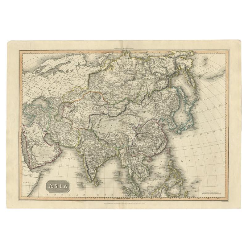
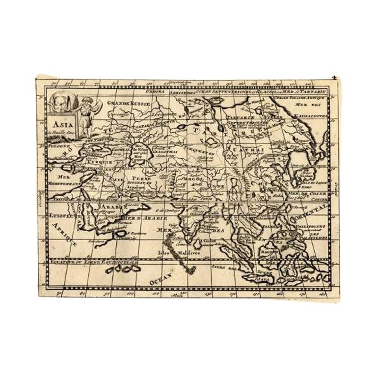
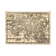
Antique Map of Asia Depicting Asia and Australia, c.1814
About the Item
Antique map titled 'Asia'. This map depicts Asia and Australia. Engraved by J. and G. Menzies and issued for Thomson's 'New General Atlas'.
Artists and Engravers: John Thomson (1777 - c. 1841) was a Scottish cartographer, publisher, and bookbinder active in Edinburgh during the early part of the 19th century. Thomson apprenticed under Edinburgh bookbinder Robert Alison.
Condition: Very good, few tears outside image border. Please study image carefully.
Date: c.1814
Overall size: 71 x 54 cm.
Image size: 51 x 45.5 cm.
We sell original antique maps to collectors, historians, educators and interior decorators all over the world. Our collection includes a wide range of authentic antique maps from the 16th to the 20th centuries. Buying and collecting antique maps is a tradition that goes back hundreds of years. Antique maps have proved a richly rewarding investment over the past decade, thanks to a growing appreciation of their unique historical appeal. Today the decorative qualities of antique maps are widely recognized by interior designers who appreciate their beauty and design flexibility. Depending on the individual map, presentation, and context, a rare or antique map can be modern, traditional, abstract, figurative, serious or whimsical. We offer a wide range of authentic antique maps for any budget.
- Dimensions:Height: 21.26 in (54 cm)Width: 27.96 in (71 cm)Depth: 0 in (0.01 mm)
- Materials and Techniques:
- Period:
- Date of Manufacture:circa 1814
- Condition:
- Seller Location:Langweer, NL
- Reference Number:
About the Seller
5.0
Platinum Seller
These expertly vetted sellers are 1stDibs' most experienced sellers and are rated highest by our customers.
Established in 2009
1stDibs seller since 2017
1,950 sales on 1stDibs
Typical response time: <1 hour
- ShippingRetrieving quote...Ships From: Langweer, Netherlands
- Return PolicyA return for this item may be initiated within 14 days of delivery.
More From This SellerView All
- Large Antique Map of the Asian Continent, 1814Located in Langweer, NLAntique map titled 'Asia'. Large antique map of the Asian continent. Drawn under the direction of Mr. Pinkerton by L. Hebert. Artists and Engraver...Category
Antique 19th Century Maps
MaterialsPaper
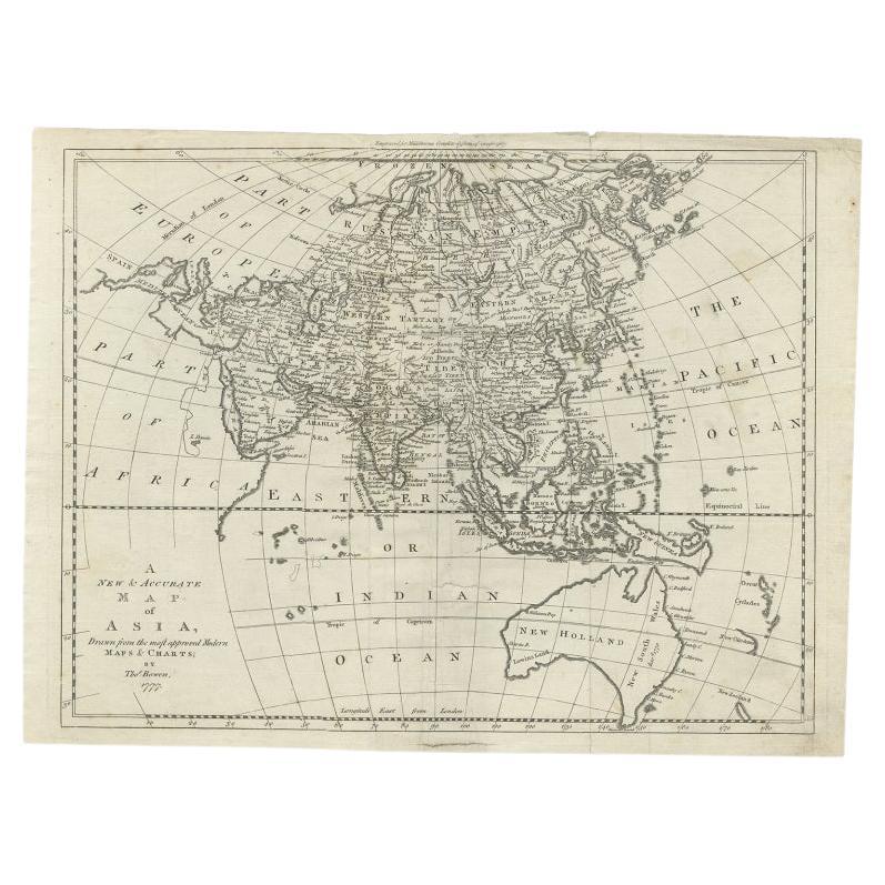
- Antique Map of Asia and Australia with a Speculative Coastline, 1777Located in Langweer, NLAntique map titled 'A New & Accurate Map of Asia'. Detailed map of Asia and Australia, shows a still largely speculative Southern Australian coastline. Originates from Middleton's 'C...Category
Antique 18th Century Maps
MaterialsPaper
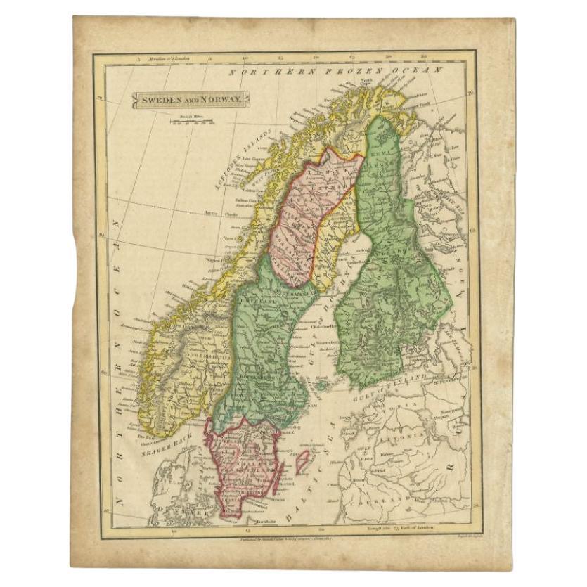
- Antique Map of Sweden and Norway by Russell, 1814Located in Langweer, NLAntique map Scandinavia titled 'Sweden & Norway'. Antique map of Scandinavia with a focus on Sweden and Norway. Artists and Engravers: Engrave...Category
Antique 19th Century Maps
MaterialsPaper
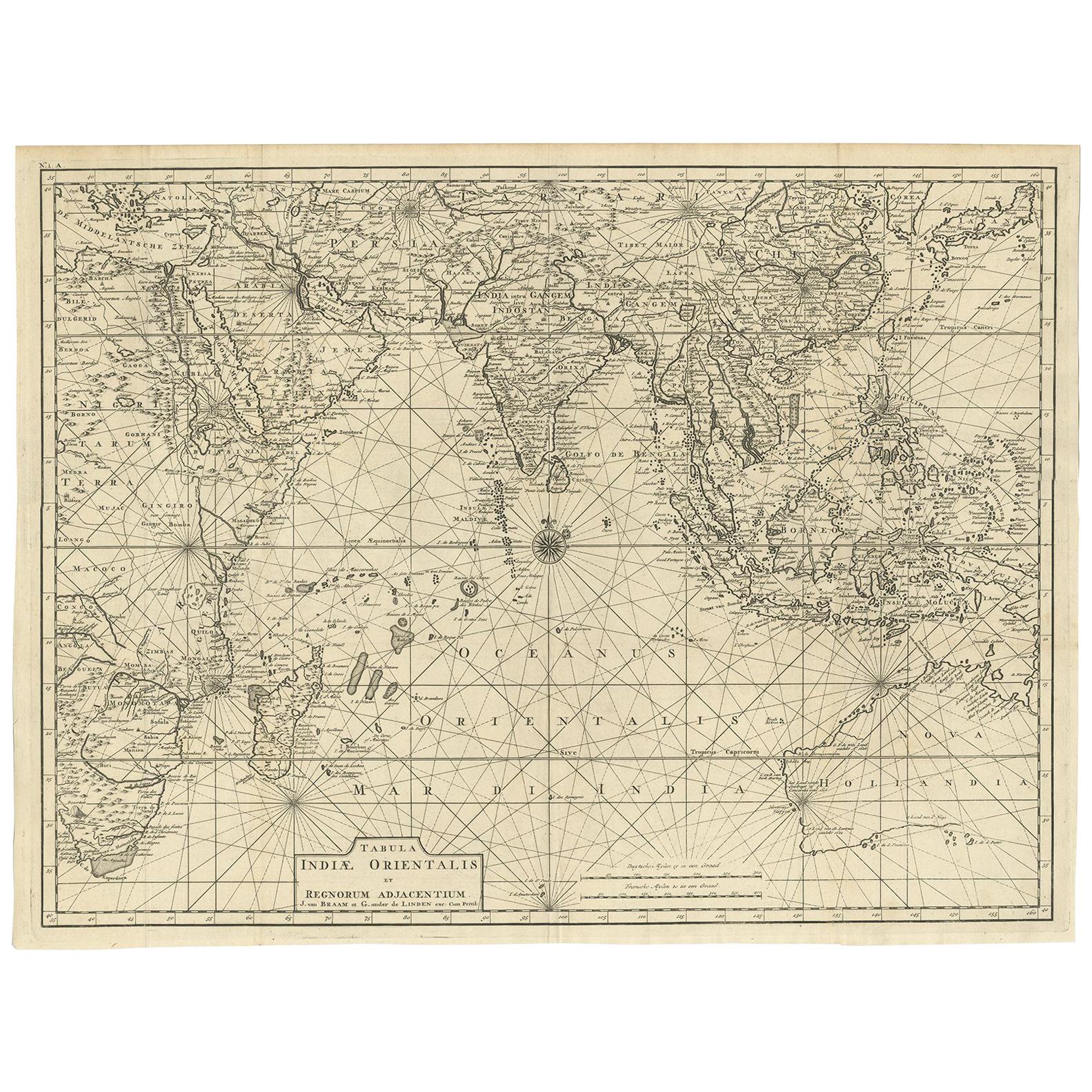
- Antique Map of South East Asia, Australia and the Indian Ocean, 1726By F. ValentijnLocated in Langweer, NLAntique map titled 'Tabula Indiae Orientalis'. Beautiful detailed map of Australia, Southeast Asia and the Indian Ocean. The map features a fine depiction of the outlines of the western two-thirds of Australia, based on the discoveries of explorers working for the Dutch East India Company (the VOC). These include Willem Jansz's discoveries in the Gulf of Carpentaria in 1606; the encounters of Dirk...Category
Antique Mid-18th Century Dutch Maps
MaterialsPaper
- Rare Antique Map of Asia with Cartouche Depicting an Elephant, 1753Located in Langweer, NLAntique map titled 'Asia.' Original antique map of Asia. With a small cartouche depicting an elephant. Map by Daniel de la Feuille. This very rare old antique copperplate engraved pr...Category
Antique 18th Century Maps
MaterialsPaper
- Historical Map Depicting the Continent of Asia, 1882Located in Langweer, NLThis 1882 map presents a meticulously detailed representation of the continent of Asia, a testament to the cartographic skills of the era. Published as a part of 'Comprehensive Atlas...Category
Antique 1880s Maps
MaterialsPaper


You May Also Like
- Original Antique Map of Asia. C.1780Located in St Annes, LancashireGreat map of Asia Copper-plate engraving Published C.1780 Two small worm holes to right side of map Unframed.Category
Antique Early 1800s English Georgian Maps
MaterialsPaper

- 1814 Map of "Russian Empire" Ric.r032Located in Norton, MA1814 Map of "Russian Empire" Ric.r032 Russian Empire. Description: This is an 1814 John Thomson map of the Russian Empire. The map depicts the region from the Baltic Sea, Prussia, and Sweden to the Aleutian Islands and from the Arctic Ocean to the Yellow River. Highly detailed, myriad cities, towns, and villages are labeled throughout, including St. Petersburg, Moscow, Minsk, Kiev, and Kharkov. Rivers and mountain ranges are also identified, as are islands and numerous locations along the coastlines. It is important to note that the long-disputed sea between Korea and Japan is identified as the 'Sea of Japan. Historical Context: In 1815, Tsarist Russia emerged from the Napoleonic Wars economically insolvent and politically fearful of the Revolutionary fervor that had just swept through Europe. In order to shore up Russia's economic position, the Tsars began an aggressive series of expansions into the Caucuses and Central Asia that would vastly increase the landmass of the Russian Empire. Publication History Thomson maps are known for their stunning color, awe inspiring size, and magnificent detail. Thomson's work, including this map, represents some of the finest cartographic art...Category
Antique 19th Century Unknown Maps
MaterialsPaper
- Large Original Antique Map of Australia, Fullarton, C.1870Located in St Annes, LancashireGreat map of Australia From the celebrated Royal Illustrated Atlas Engraved by Swanston after the drawing by Augustus Petermann Lithograph. Original color. Published by ...Category
Antique 1870s Scottish Maps
MaterialsPaper
- Antique Puzzle of Colored Cardboard Depicting World Map, Europe and FranceLocated in Milan, ITEducational puzzle of colored cardboard composed of three folders depicting world map, Europe and France. The world map in addition to the territorial map of the continents depicts t...Category
Antique 1850s French Games
MaterialsPaper
- Original Antique Map of South East Asia, Arrowsmith, 1820Located in St Annes, LancashireGreat map of South East Asia Drawn under the direction of Arrowsmith Copper-plate engraving Published by Longman, Hurst, Rees, Orme and Brown, 1820 Unframed.Category
Antique 1820s English Maps
MaterialsPaper
- Large Original Antique Map of Australia by Sidney Hall, 1847Located in St Annes, LancashireGreat map of Australia Drawn and engraved by Sidney Hall Steel engraving Original colour outline Published by A & C Black. 1847 Unframed Free shipping.Category
Antique 1840s Scottish Maps
MaterialsPaper


Recently Viewed
View AllMore Ways To Browse
Australian Designer Furniture
Australian Antiques
Australia 19th Century
Australian Antique Furniture
Antique Furniture In Australia
Australia Antique Furniture
Map Australia
Used Office Furniture Edinburgh
Maps Of Australia
Edinburgh Antiques
Antique Apprentice Furniture
Antique Apprentice
19th Century Australian Furniture
Antique Map Border
Scotland Map
Antique Scottish Maps
Antique Map Scotland
Antique Map Of Scotland