Items Similar to Antique Map of Northeastern India, Nepal, Bhutan, Assam and Bangladesh

Want more images or videos?
Request additional images or videos from the seller
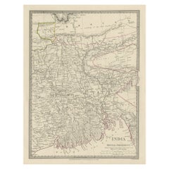
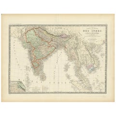
Antique Map of Northeastern India, Nepal, Bhutan, Assam and Bangladesh
About the Item
Antique map titled 'De Land-Reyse door Benedictus Goes, van Lahor gedaan, door Tartaryen na China'. Interesting map showing the region of northeastern India, Nepal, Bhutan, Assam and Bangladesh. At center is the imaginary Chiamaeus Lacus with four huge rivers flowing south into Bangladesh and Burma. Decorated with a pictorial title cartouche of a council in a large tent. The map illustrates the narrative of the travels of Benedictus Goes, a Jesuit who left Lahore in 1603 bound eastward for Peshwar. During his travels, he encountered a hermit who told him of the City of Capherstam, whose inhabitants dealt severely with Muslims, but permitted others to enter their territory. The hermit had apparently been to the city and tasted its wine. Capherstam is believed to be Kafiristan. Published by P. van der Aa, circa 1714.
- Dimensions:Height: 12.72 in (32.3 cm)Width: 17.21 in (43.7 cm)Depth: 0.02 in (0.5 mm)
- Materials and Techniques:
- Period:
- Date of Manufacture:c.1714
- Condition:General age-related toning. Shows some staining, mainly in margins. Minor wear and soiling, blank verso. Please study image carefully.
- Seller Location:Langweer, NL
- Reference Number:
About the Seller
5.0
Platinum Seller
These expertly vetted sellers are 1stDibs' most experienced sellers and are rated highest by our customers.
Established in 2009
1stDibs seller since 2017
1,951 sales on 1stDibs
Typical response time: <1 hour
- ShippingRetrieving quote...Ships From: Langweer, Netherlands
- Return PolicyA return for this item may be initiated within 14 days of delivery.
More From This SellerView All
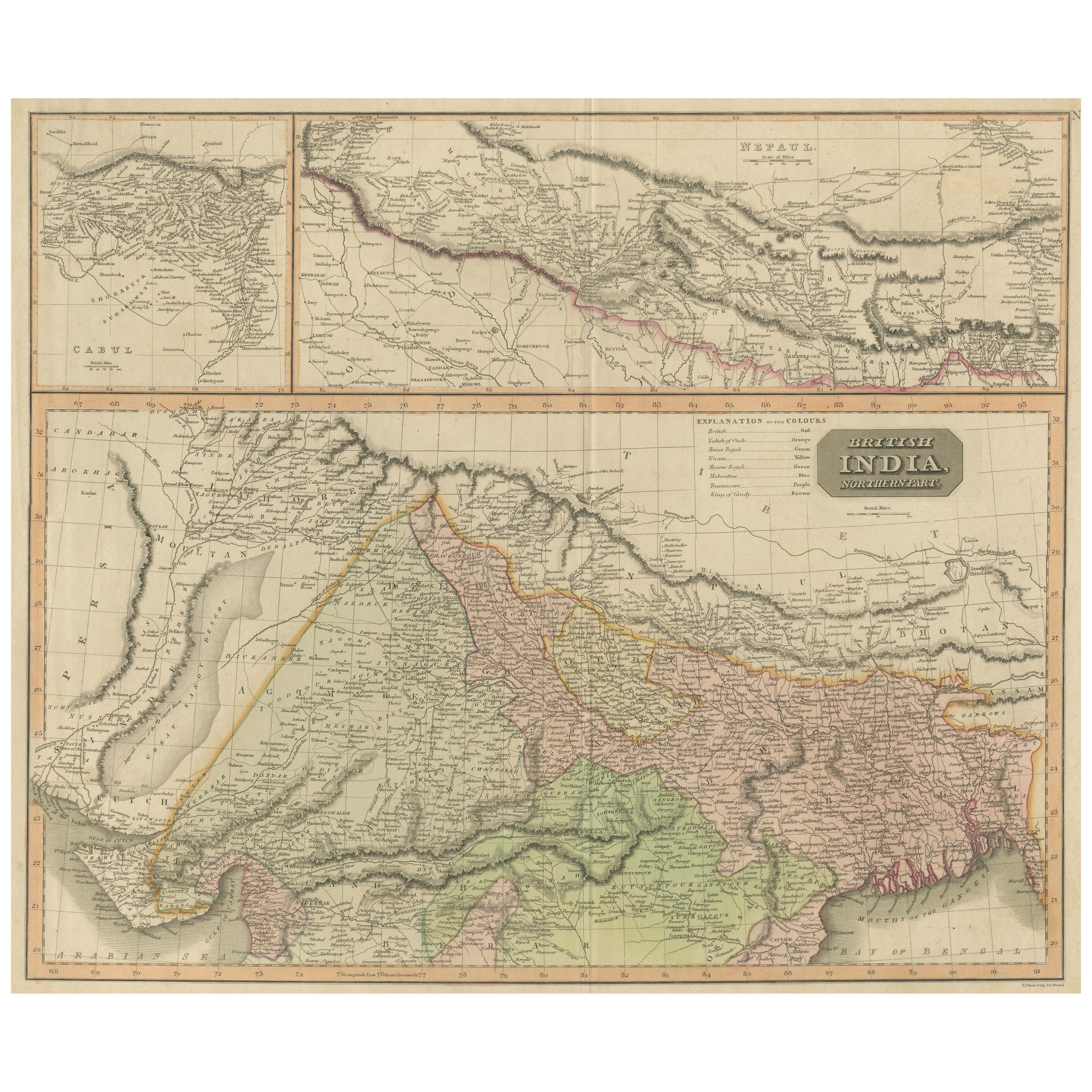
- Antique Map of British India with Insets of Kabul and NepalLocated in Langweer, NLAntique map titled 'British India, northern part'. Large format map of the northern area of the Indian subcontinent. The map is engraved in the minimalist English style pioneered in ...Category
Antique Early 19th Century Maps
MaterialsPaper
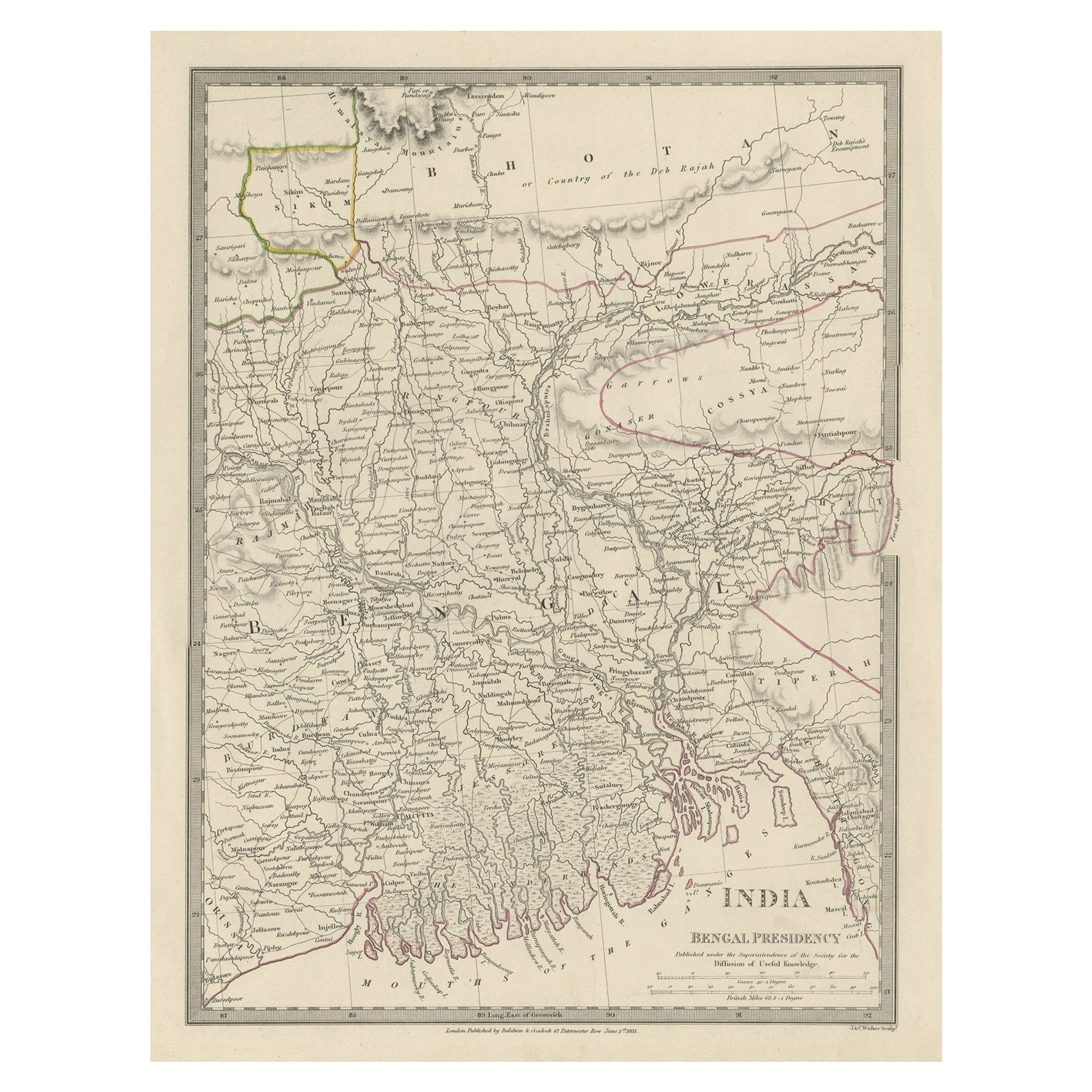
- Steel Engraved Map of Part of the Bengal Presidency 'India & Bangladesh', 1831Located in Langweer, NLAntique map titled 'India Bengal Presidency'. Old steel engraved map of part of the Bengal Presidency. The Bengal Presidency (1757–1912), later reorganized as the Bengal Province (19...Category
Antique 1830s Maps
MaterialsPaper
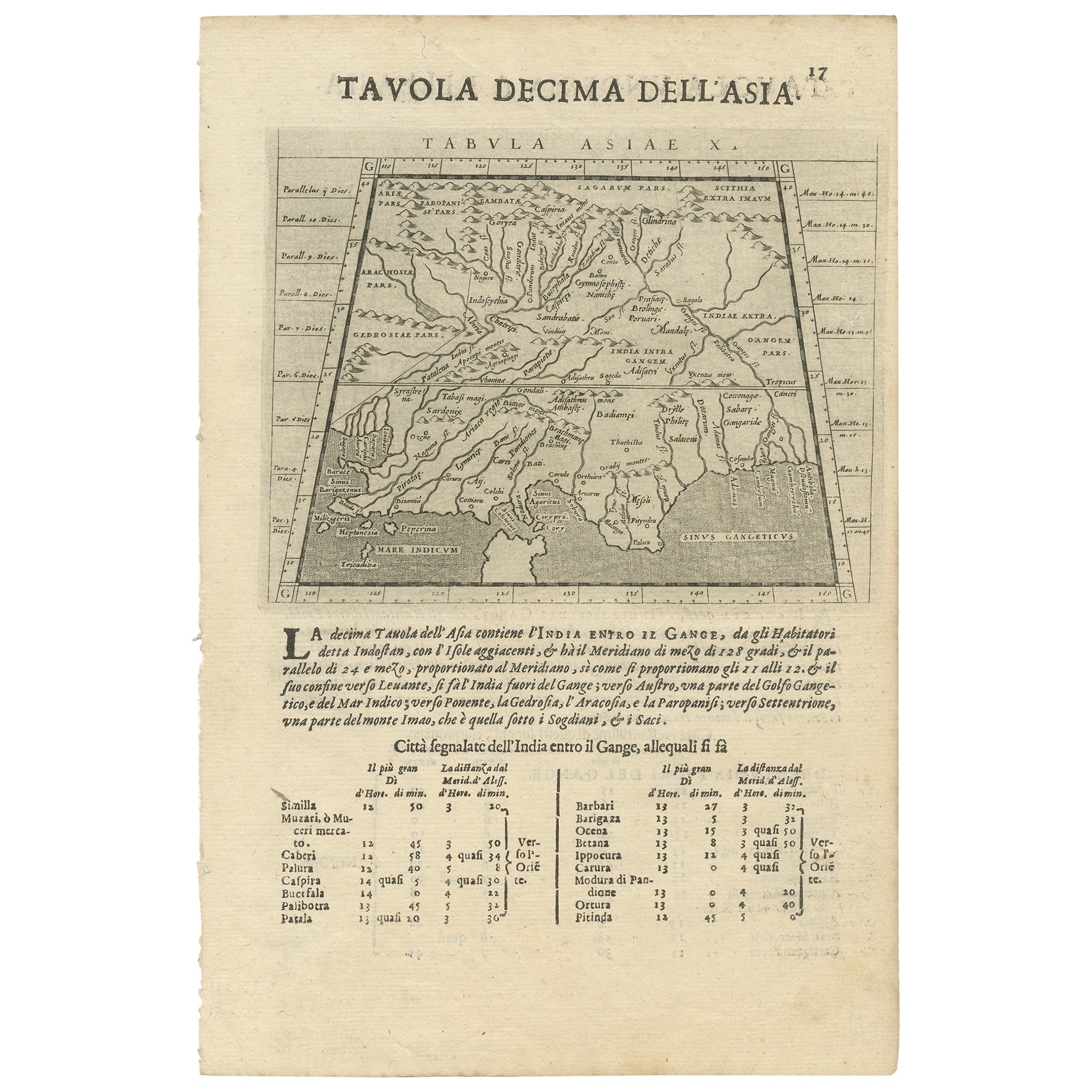
- Two Maps of Asia on One Sheet, India, Bangladesh and Malaysia & Burma etc., 1617Located in Langweer, NLAntique map titled 'Tabula Asiae'. Two maps of Asia on one sheet, recto and verso. The recto features an interesting map of India, Bangladesh and the Ganges River. On the verso, ...Category
Antique 1610s Maps
MaterialsPaper
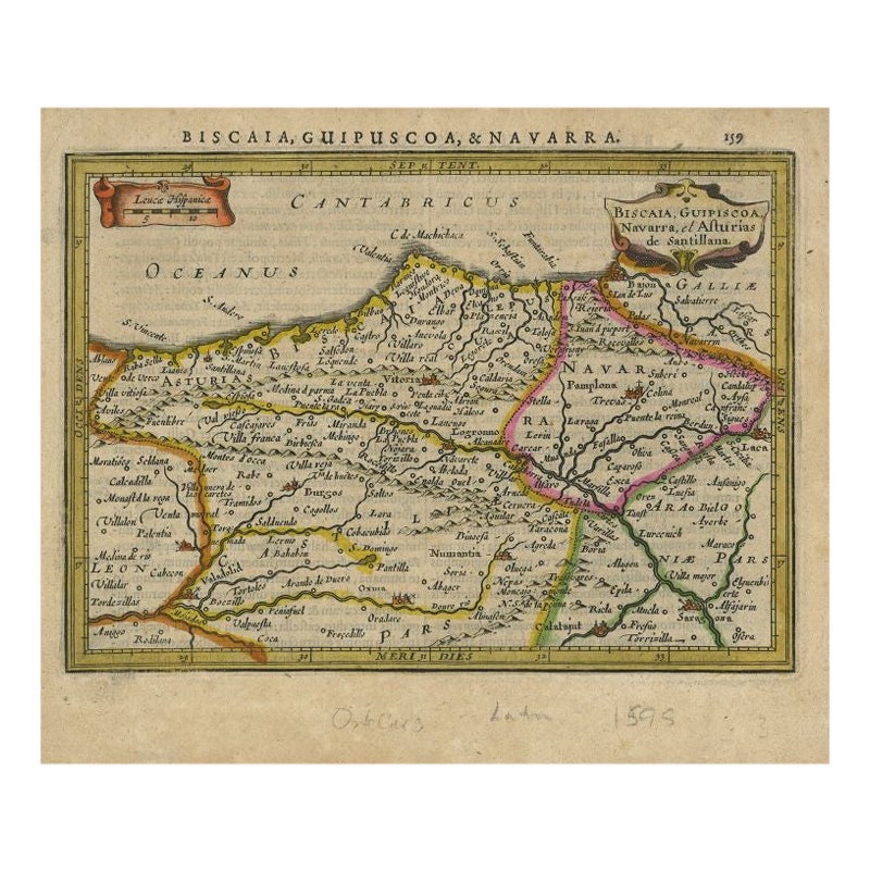
- Antique Map of Northeastern Spain by Mercator, 1634Located in Langweer, NLAntique map titled 'Biscaia, Guipiscoa, Navarra et Asturias de Santillana'. Charming map of Northeastern Spain with the areas of Pamplona and Valladolid. This map originates from 'At...Category
Antique 17th Century Maps
MaterialsPaper
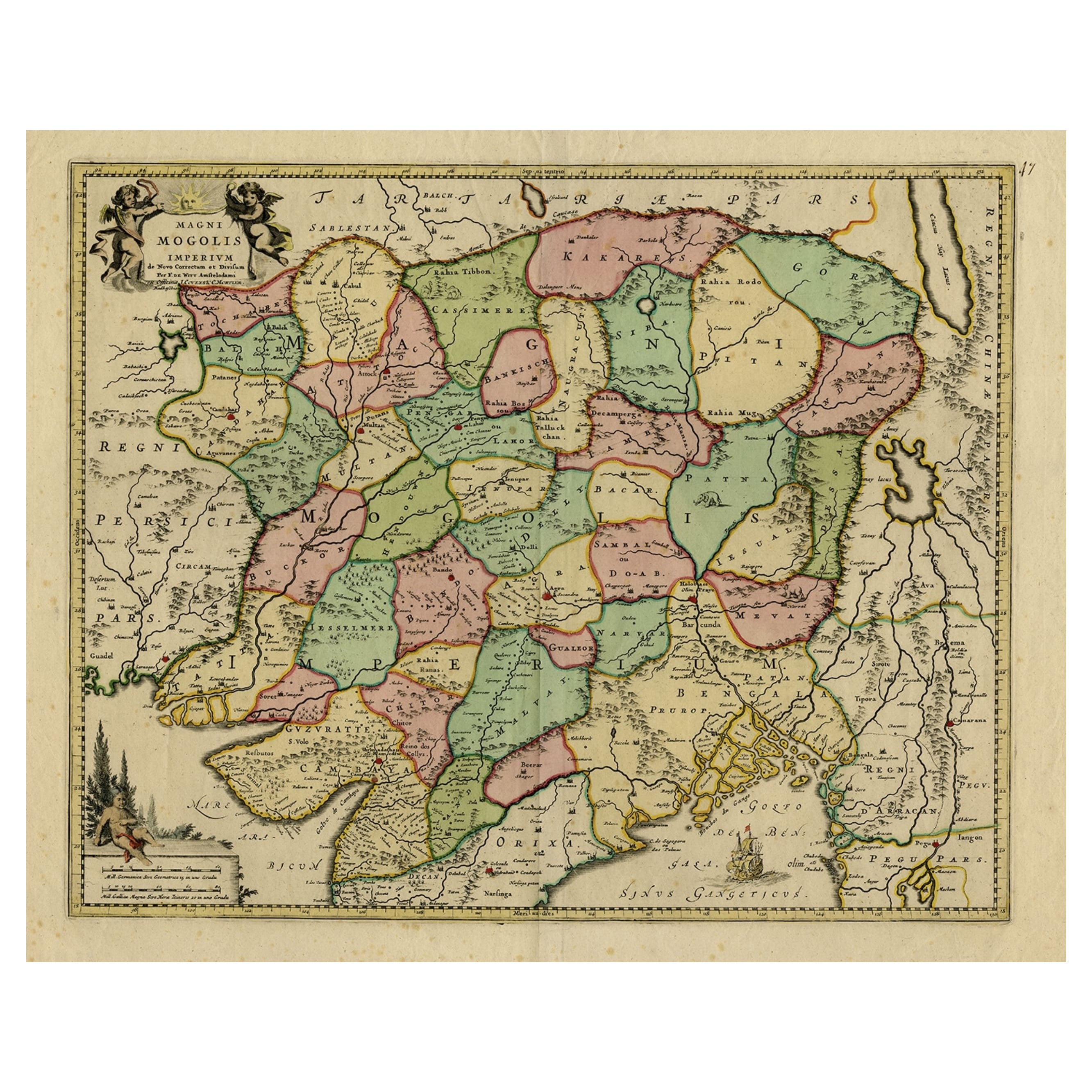
- Map of Northern India & Surrounding Regions, incl Kabul, Candahar & Bhutan, 1710Located in Langweer, NLAntique map titled 'Magni Mogolis Imperium de Novo Correctum et Divisum Per F. de Witt Amstelodami.' Map of Northern India and surrounding regions. This includes Kabul and Candah...Category
Antique 1710s Maps
MaterialsPaper
- Authentic Antique Map of India and Ceylon, '1875'Located in Langweer, NLAntique map titled 'Carte générale des Indes'. Large map of India and Ceylon. This map originates from 'Atlas de Géographie Moderne Physique et Politique' by A. Levasseur. Published ...Category
Antique Late 19th Century Maps
MaterialsPaper


You May Also Like
- Original Antique Map of India. C.1780Located in St Annes, LancashireGreat map of India Copper-plate engraving Published C.1780 Three small worm holes to right side of map and one bottom left corner Unframed.Category
Antique Early 1800s English Georgian Maps
MaterialsPaper

- Antique French Map of Asia Including China Indoneseia India, 1783Located in Amsterdam, Noord HollandVery nice map of Asia. 1783 Dedie au Roy. Additional information: Country of Manufacturing: Europe Period: 18th century Qing (1661 - 1912) Condition: Overall Condition B (Good Used)...Category
Antique 18th Century European Maps
MaterialsPaper
- Antique 1803 Italian Map of Asia Including China Indoneseia IndiaLocated in Amsterdam, Noord HollandAntique 1803 Italian Map of Asia Including China Indoneseia India Very nice map of Asia. 1803. Additional information: Type: Map Country of Manufacturing: Europe Period: 19th centu...Category
Antique 19th Century European Maps
MaterialsPaper
- 1854 Map of Massachusetts, Connecticut and Rhode Island, Antique Wall MapLocated in Colorado Springs, COThis striking wall map was published in 1854 by Ensign, Bridgman & Fanning and has both full original hand-coloring and original hardware. This impression is both informative and highly decorative. The states are divided into counties, outlined in red, green, and black, and subdivided into towns. Roads, canals, and railroad lines are prominently depicted, although they are not all labeled. The mapmakers also marked lighthouses, banks, churches, and prominent buildings, with a key at right. The map is an informative and comprehensive overview of the infrastructural development of New England prior to the Civil War. Physical geographies depicted include elevation, conveyed with hachure marks, rivers and lakes. The impression features an inset map of Boston...Category
Antique 19th Century American Maps
MaterialsPaper
- Antique Map of Principality of MonacoBy Antonio Vallardi EditoreLocated in Alessandria, PiemonteST/619 - "Old Geographical Atlas of Italy - Topographic map of ex-Principality of Monaco" - ediz Vallardi - Milano - A somewhat special edition ---Category
Antique Late 19th Century Italian Other Prints
MaterialsPaper
- Original Antique Map of Spain and Portugal, circa 1790Located in St Annes, LancashireSuper map of Spain and Portugal Copper plate engraving by A. Bell Published, circa 1790. Unframed.Category
Antique 1790s English Other Maps
MaterialsPaper


Recently Viewed
View AllMore Ways To Browse
Oversized Map
Atlas School Supply
Matthew Seutter On Sale
Menorca Map
Pierre Fran�ois Tardieu On Sale
Rand Mcnally Map Of Kansas
Sumba Map
Vincenzo Coronelli On Sale
1681 Moses Pitt
Antique Cabbage Cutter
Antique Maps Denver
Antique Maps Washington Dc
Map Of Charlevoix
Marthas Vineyard Map
Union Pacific Map
Rand Mcnally Map Of California
Map Of Indonesia
United States Antique Map