Items Similar to Authentic Old Map of Sumatra, Malaysia and Singapore, 1745


Want more images or videos?
Request additional images or videos from the seller
1 of 6
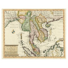
Authentic Old Map of Sumatra, Malaysia and Singapore, 1745
About the Item
Title: "Kaartje van't Eiland Sumatra en de Maleidse Kust gelegen na de stelling van de G. de L'Isle"
Published by Jacob Keizer and by Jan de Lat
Creator: Keizer, Jacob, active 1706-1750
Size: 17.10 x 24.20cm.
The phrase "Kaartje van't Eiland Sumatra en de Maleidse Kust gelegen na de stelling van de G. de L'Isle" translates to "Map of the Island of Sumatra and the Malayan Coast based on the work of G. de L'Isle."
This indicates a map that depicts the Island of Sumatra along with the coastline of the Malay Peninsula and Singapore, based on the cartographic work of the prominent French cartographer, Guillaume de L'Isle.
Sumatra is one of the largest islands in Indonesia, known for its diverse landscapes, including tropical rainforests, volcanic terrain, and rich cultural heritage. The Malay Peninsula is a region comprising part of Malaysia and Thailand, with a long coastline along the western side of the South China Sea and Singapore at the southern tip.
This map lrepresents the geographical features, cities, rivers, and other notable landmarks of Sumatra and the coastal areas of the Malay Peninsula, reflecting the cartographic expertise and accuracy associated with the works of Guillaume de L'Isle. It serves as a historical document, offering insights into the understanding of these regions during the period when the map was created, likely showcasing the advancements in cartography and geographical knowledge of that time.
- Dimensions:Height: 6.7 in (17 cm)Width: 9.45 in (24 cm)Depth: 0 in (0.02 mm)
- Materials and Techniques:Paper,Engraved
- Period:1740-1749
- Date of Manufacture:1745
- Condition:Very Good. Three folding lines. Margin on the lower left is a bit tight, but leaves space for matting or framing. Study the image carefully.
- Seller Location:Langweer, NL
- Reference Number:
About the Seller
5.0
Platinum Seller
These expertly vetted sellers are 1stDibs' most experienced sellers and are rated highest by our customers.
Established in 2009
1stDibs seller since 2017
1,940 sales on 1stDibs
Typical response time: <1 hour
- ShippingRetrieving quote...Ships From: Langweer, Netherlands
- Return PolicyA return for this item may be initiated within 14 days of delivery.
More From This SellerView All
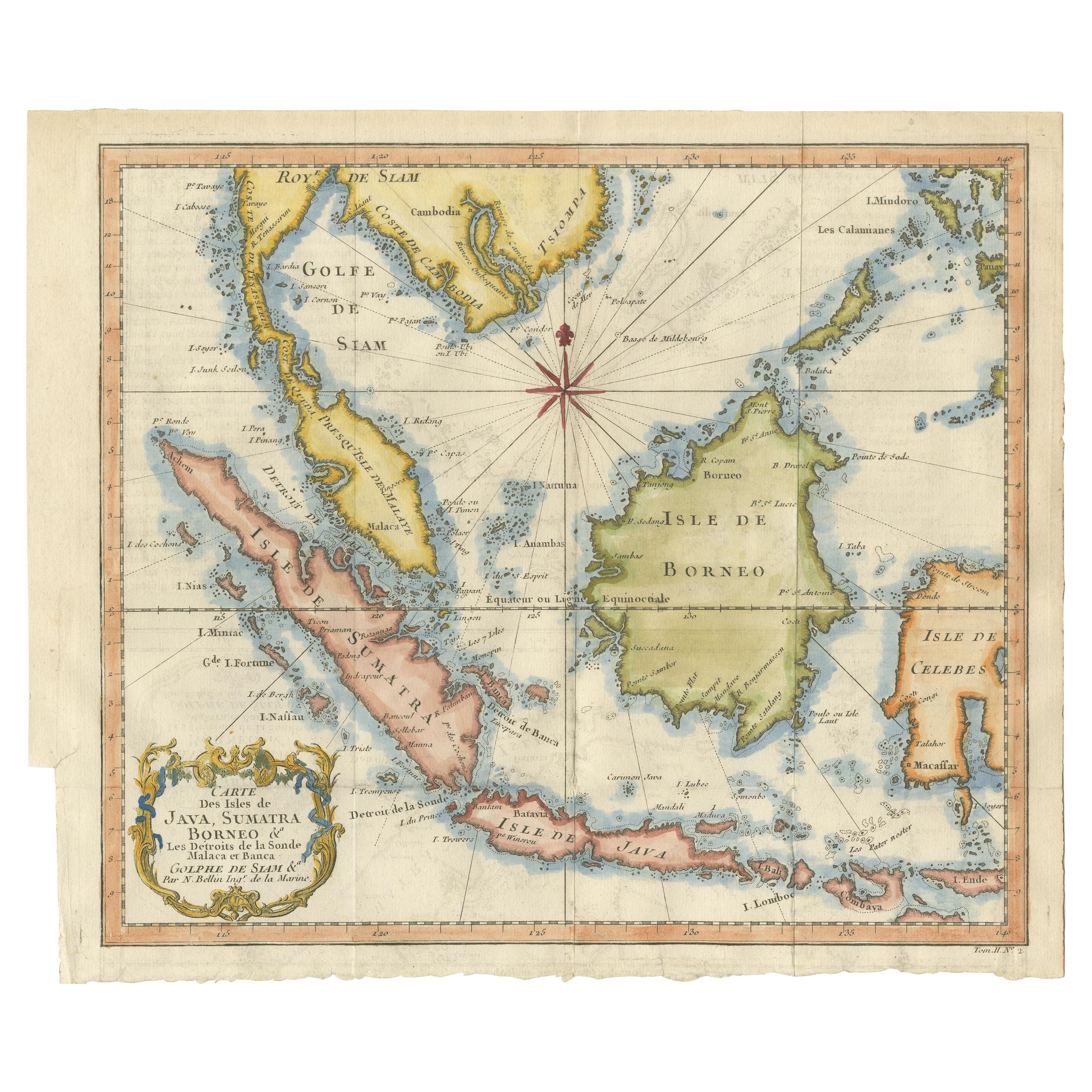
- Antique Map of Singapore, Malaysia, Borneo, Sumatra and Java (Indonesia), 1739Located in Langweer, NL"Antique map titled 'Nieuwe kaart van de Sundasche Eilanden als Borneo, Sumatra en Groot Iava & c'. Detailed map of Southeast Asia, extending from the tip of Cambodia to Java. This m...Category
Antique 18th Century Maps
MaterialsPaper
- Antique Engraving of Malaysia, Brunei, Singapore, Java, Borneo, Sumatra, c.1750Located in Langweer, NLNice decorative and detailed map from the Gulf of Siam and Mindoro to Timo, Java and Sumatra Borneo and Roy de Siam. Large compass rose and nice cartouche. Title: Carte des Isles ...Category
Antique Mid-18th Century Maps
MaterialsPaper
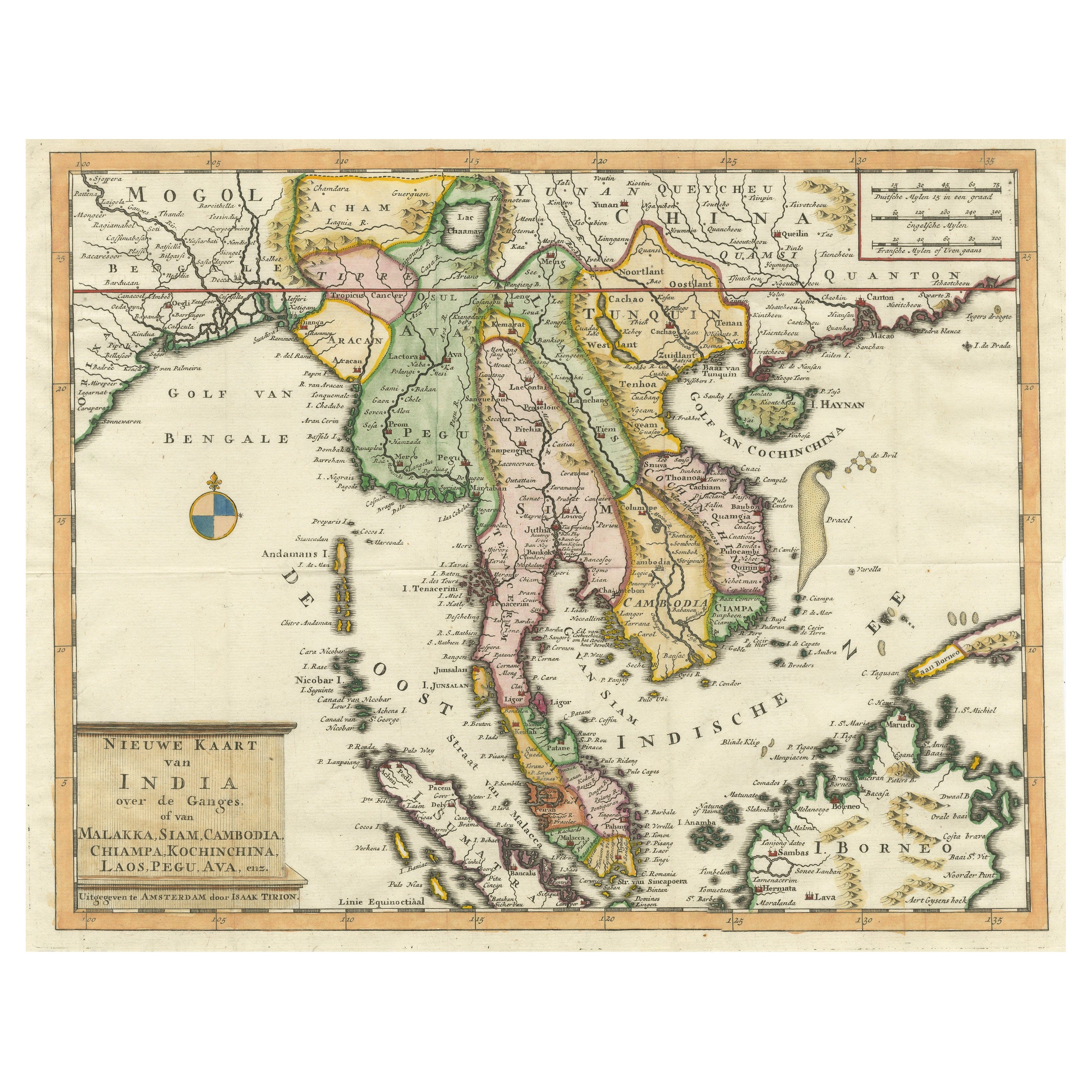
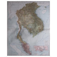
- Antique Map of Indochina, the Malaysian Peninsula and Northern SumatraLocated in Langweer, NLAntique map titled 'Nieuwe Kaart van India over de Ganges of van Malakka, Siam, Cambodia, Chiampa, Kochinchina, Laos, Pegu, Ava, enz'. Original old map of Indochina, the Malaysian Pe...Category
Antique Mid-18th Century Maps
MaterialsPaper
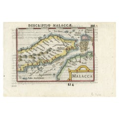
- Rare Original Handcolored Miniature Map of Malaysia and Singapore, 1600Located in Langweer, NLVery handsome original old coloured copper engraving of Malaysia and Singapore, with parts of Sumatra, inc the island of Bangka and Bintam. Title of the map 'Description Malacca'. On...Category
Antique Early 1600s Maps
MaterialsPaper
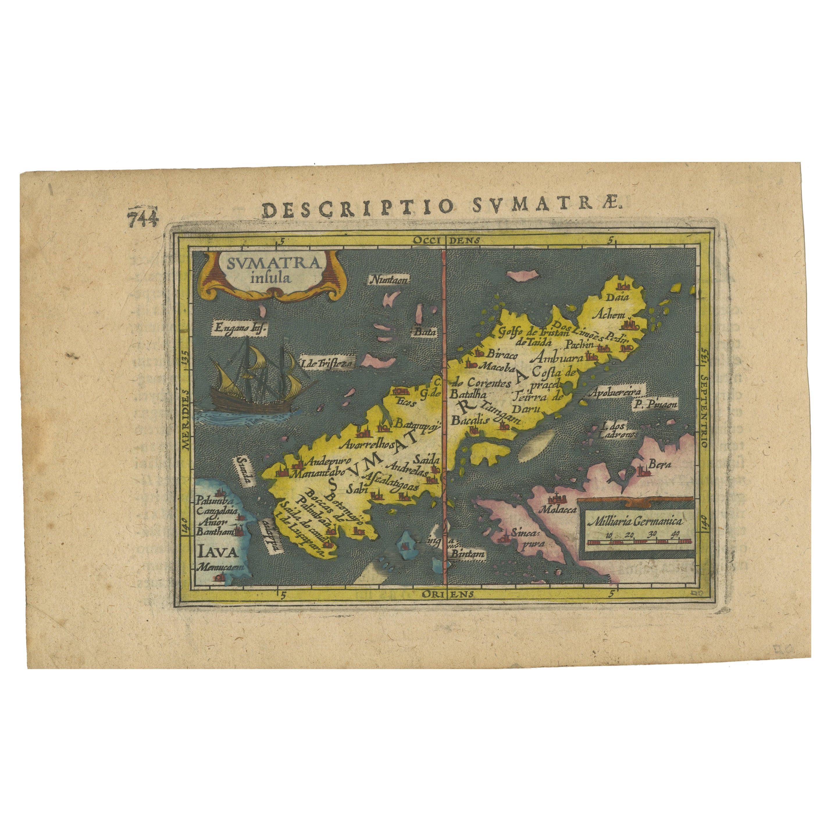
- 1616 Bertius Map of Sumatra, Singapore and the Straits of MalaccaLocated in Langweer, NLTitle: "1616 Bertius Map of Sumatra and the Straits of Malacca" Description: This is an exquisite 1616 original antique map by Petrus Bertius, titled "Sumatra Insula," showcasing Su...Category
Antique Early 17th Century Maps
MaterialsPaper
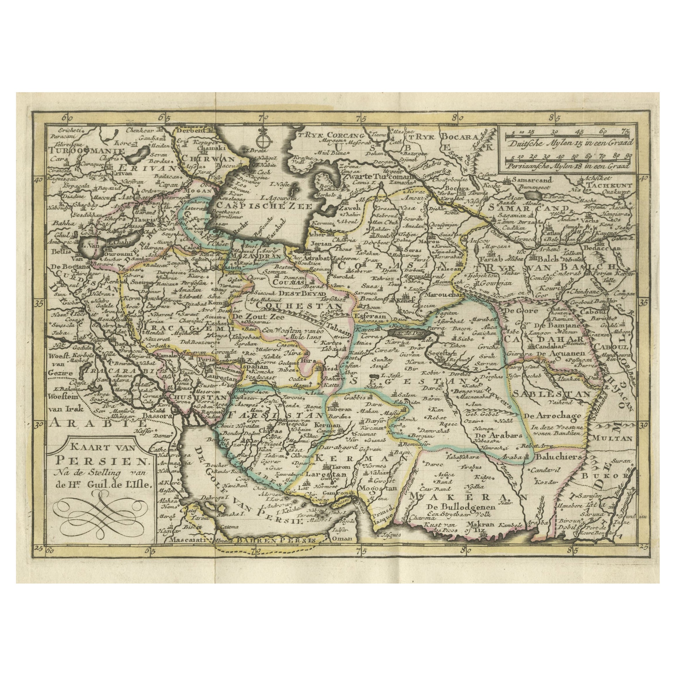
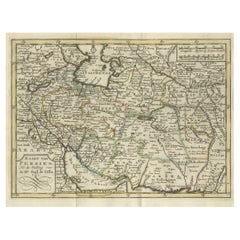
- Authentic Old Map of Persia with Original Border Coloring, 1745Located in Langweer, NLTitle: "Kaartje van Persien na de stelling van den Heer Guillaume de L'Isle" Translates to "Map of Persia based on the work of Mr. Guillaume de L'Isle." Guillaume de L'Isle was a p...Category
Antique 1740s Maps
MaterialsPaper


You May Also Like
- Large Original Vintage Map of S.E Asia, with a Vignette of SingaporeLocated in St Annes, LancashireGreat map of South East Asia Original color. Good condition Published by Alexander Gross Unframed.Category
Vintage 1920s English Maps
MaterialsPaper
- Old Nautical Map of CorsicaLocated in Alessandria, PiemonteST/556/1 - Old map of Corsica isle, surveyed by Captain Hell, of the French Royal Navy in 1824, engraved and published on 1874, with additions and corre...Category
Antique Early 19th Century English Other Prints
MaterialsPaper
- Old Horizontal Map of EnglandBy TassoLocated in Alessandria, PiemonteST/520 - Old rare Italian map of England, dated 1826-1827 - by Girolamo Tasso, editor in Venise, for the atlas of M.r Le-Sage.Category
Antique Early 19th Century Italian Other Prints
MaterialsPaper
- Antique Carte de L'Inde Myanmar, Malaysia Vietnam Map of Asia the Chinese EmpireLocated in Amsterdam, Noord HollandAntique Carte de L'Inde Myanmar, Malaysia Vietnam Map of Asia the Chinese Empire Very nice map of Asia. Additional information: Type: Map Country of Man...Category
Antique 18th Century European Maps
MaterialsPaper
- XL Old School Map of Belgium 'Printed by Procure', 1950sLocated in Oostende, BEXL Old school map of Belgium (Printed by Procure). Presumably from around 1950-1960.Category
Vintage 1950s Belgian Mid-Century Modern Maps
MaterialsMetal
- Map of Boston and Surrounding TownsLocated in Norwell, MALater copy of a nineteenth century map of Boston and surrounding towns. Showing parts of Quincy, Milton, Hyde Park, Winthrop and Revere. Showing all of B...Category
Antique 19th Century North American Maps
MaterialsPaper


Recently Viewed
View AllMore Ways To Browse
Map Of Ceylon
Old French Map
John Tallis Map
Australia Captain Cook
Map Zanzibar
Topographical Globe
Dan Rizzi
Formosa Vintage Map
Vincenzo Coronelli On Sale
Willem Blaeu On Sale
Antique Map Of Republic Of Texas
Antique Maps Denver
Cartier 1730
Collectible Barbies
Devonia Antique
J Karte
Map Cleveland
Union Pacific Map