Items Similar to Cartographic Elegance of Touraine: A 17th-Century Map Showing French Heritage

Want more images or videos?
Request additional images or videos from the seller
1 of 7
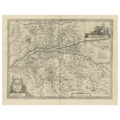
Cartographic Elegance of Touraine: A 17th-Century Map Showing French Heritage
About the Item
"Ducatus Turonensis - Touraine," is a original antique historical map of the Touraine region, which is located in the heart of France, centered around the city of Tours. Created by the Blaeu family, specifically Willem Blaeu and his son Joan Blaeu, it was first published in 1631, with this particular version coming from the 1635 edition of their famed atlas "Theatrum Orbis Terrarum."
The map is a fine example of copperplate engraving, a technique where an artist etches a design onto a smooth copper plate. This plate is then used to print the image on paper. The size of the maph is quite substantial, allowing for a significant amount of detail to be included.
Touraine itself is known for its rich history, being the garden of France due to its vineyards and fruit orchards that line the banks of the Loire River. It's also famous for its Renaissance châteaux, which dot the landscape. The region has been inhabited since antiquity and was of considerable importance during the Renaissance period, which is likely reflected in the towns, rivers, and topographic details meticulously presented on the map.
The verso of the map contains French text, which would have provided historical and geographical descriptions of the region to the map's users. This text serves as a narrative companion to the visual representation of the landscape.
As a piece from "Theatrum Orbis Terrarum," which was one of the most comprehensive and elaborately decorated atlases of the time, the map stands as a testament to the Blaeu's dedication to cartographic detail and artistic presentation. Their work represents a high point in the Golden Age of Dutch cartography, a period when the Netherlands was at the forefront of trade, science, and art.
- Dimensions:Height: 20.08 in (51 cm)Width: 23.82 in (60.5 cm)Depth: 0 in (0.02 mm)
- Materials and Techniques:Paper,Engraved
- Period:1630-1639
- Date of Manufacture:circa 1635
- Condition:Condition: Good, given age, general age-related soiling and toning but mostly outside the image. Original coloured, with some creasing along the centrefold. French text on the reverse. Please study scan carefully.
- Seller Location:Langweer, NL
- Reference Number:
About the Seller
5.0
Platinum Seller
These expertly vetted sellers are 1stDibs' most experienced sellers and are rated highest by our customers.
Established in 2009
1stDibs seller since 2017
1,947 sales on 1stDibs
Typical response time: <1 hour
- ShippingRetrieving quote...Ships From: Langweer, Netherlands
- Return PolicyA return for this item may be initiated within 14 days of delivery.
More From This SellerView All
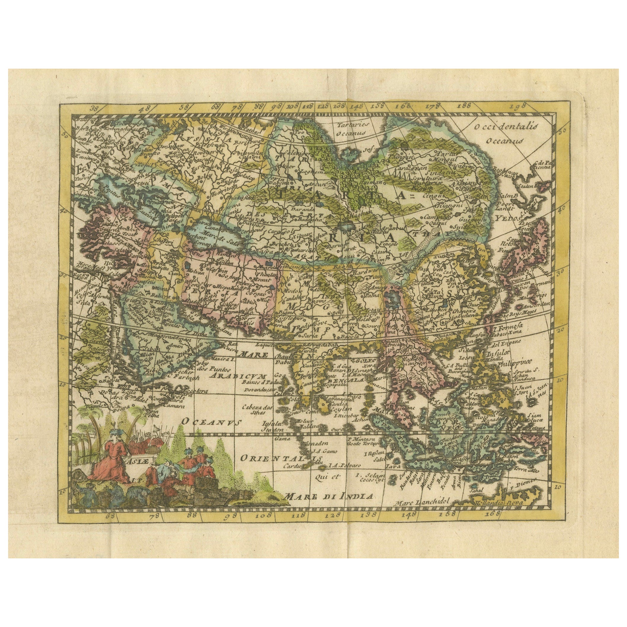
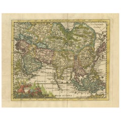
- Cartographic Elegance: The Art and Science of 17th-Century Asian Maps, ca.1681Located in Langweer, NLThis original antique map is an artifact from a pivotal era in cartography, reflecting not only the geographical knowledge of its time but also the intertwining of art and science in...Category
Antique 1680s Maps
MaterialsPaper
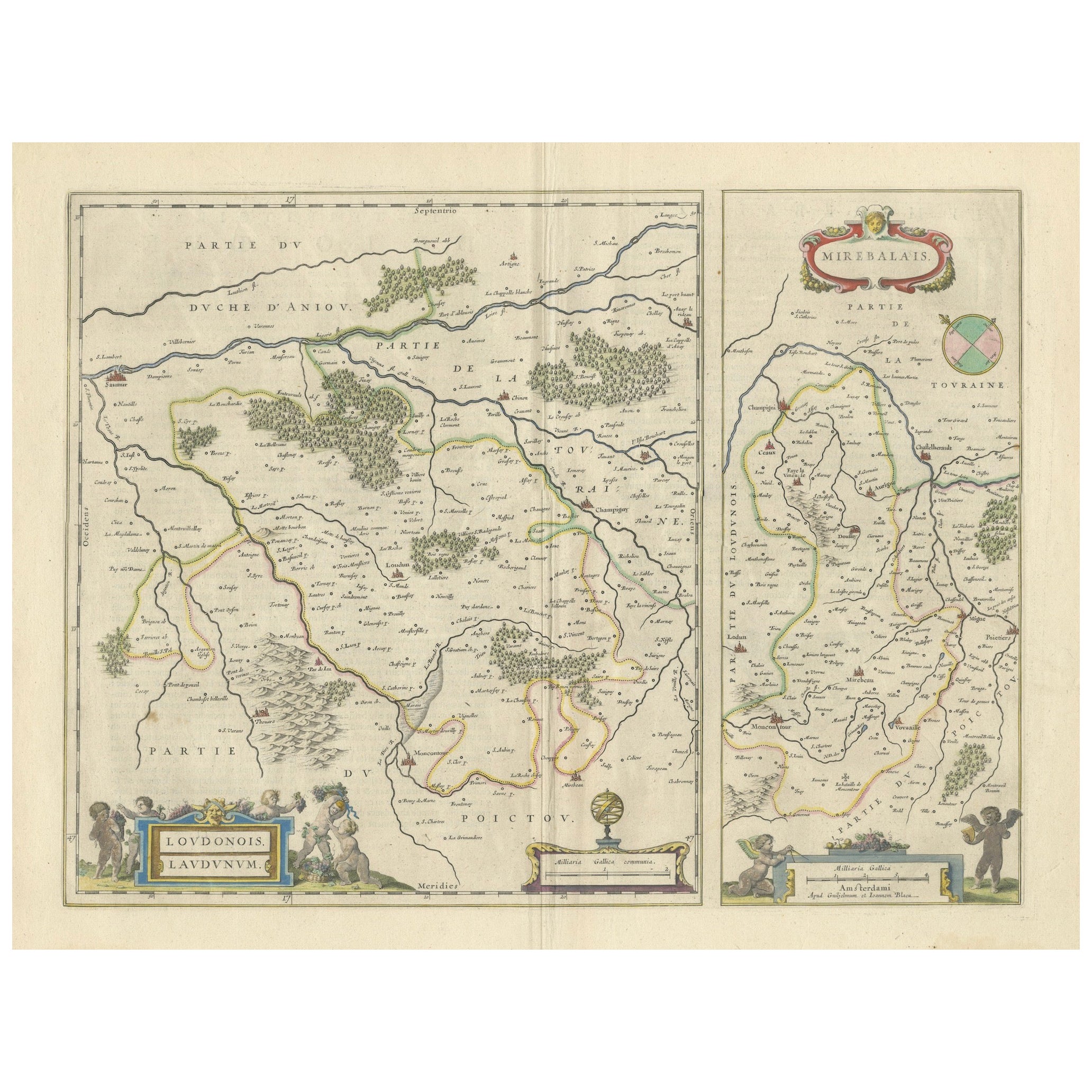
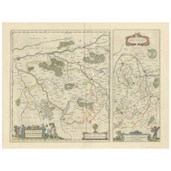
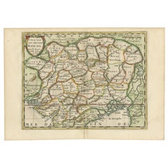
- Loudun and Mirebeau: A Cartographic Masterpiece of 17th Century France by BlaeuLocated in Langweer, NLCartography, 17th century. Willem (1571-1638) and Joan Blaeu (1596-1673), Theatrum Orbis Terrarum sive Atlas Novus..., 1635. Figure: Loudonois. Laudunum (Loudun); Mirebalais (Mirebea...Category
Antique 1650s Maps
MaterialsPaper
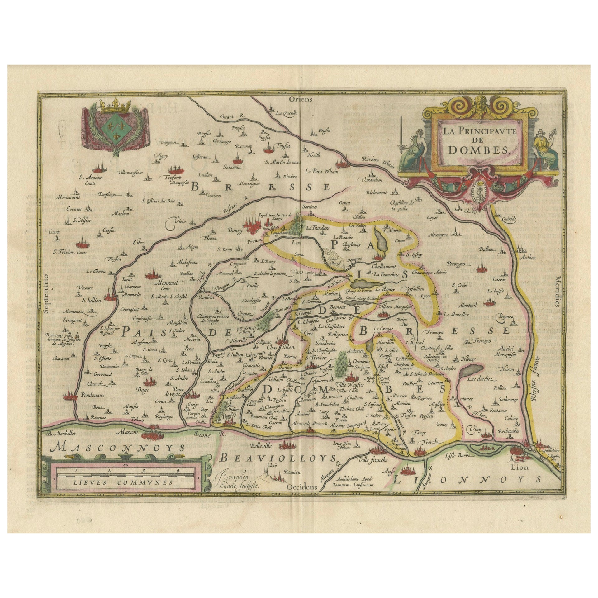
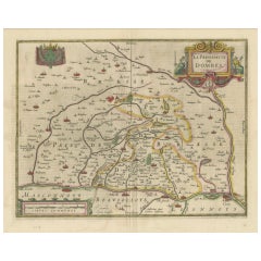
- The Principality of Dombes: A 17th-Century Cartographic Jewel by Jan JanssonLocated in Langweer, NLThe text on the map "La principaute de Dombes; J. van den Eynde sculpit.; La Principavte de Dombes" indicates that it is a map of the principality of Dombes, engraved by J. van den E...Category
Antique 1630s Maps
MaterialsPaper
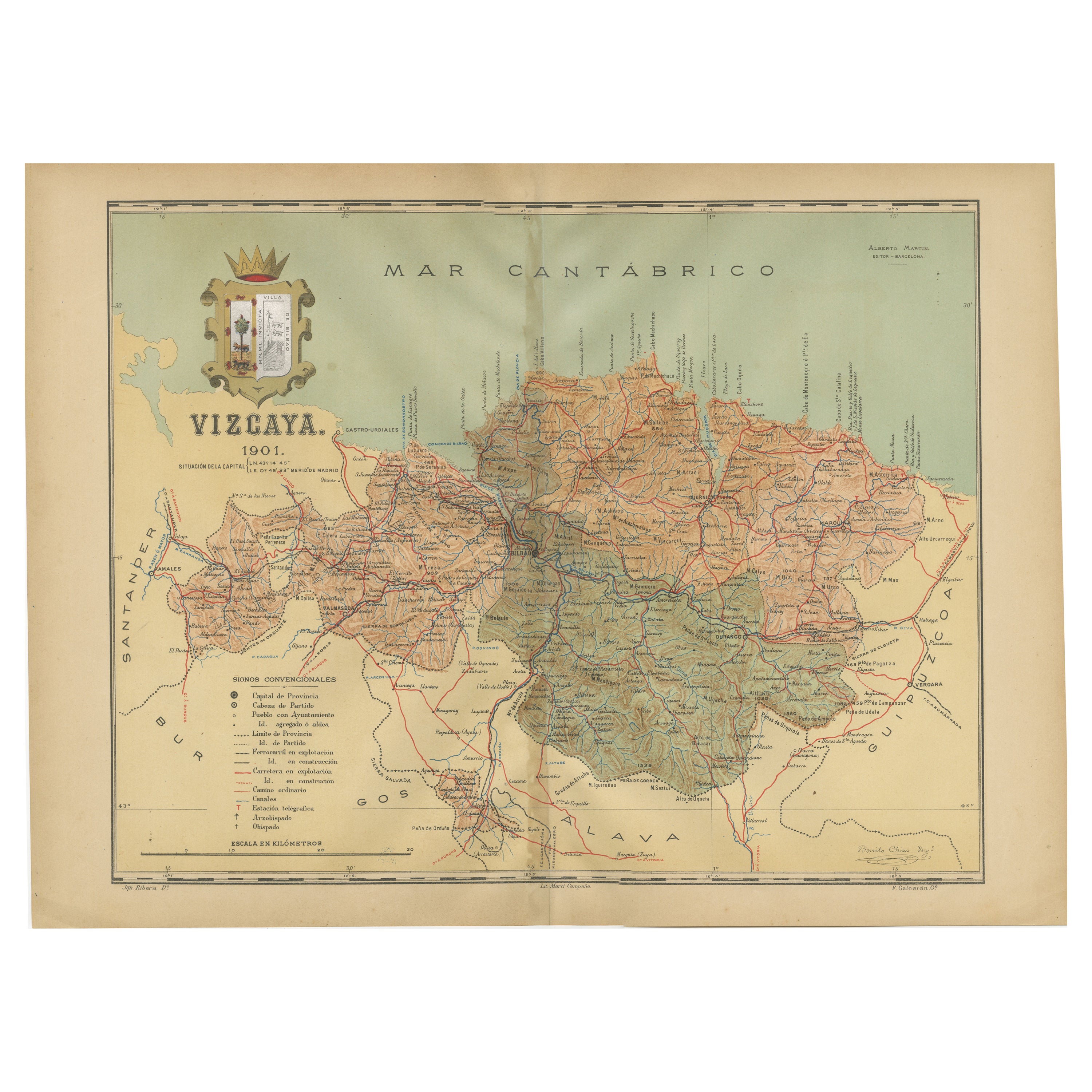
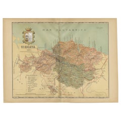
- Cartographic Heritage: The 1901 Map of the Vizcaya Province in SpainLocated in Langweer, NLThis is a historical map of the province of Vizcaya (Biscay) in Spain, dated 1901. The title on the map is "VIZCAYA. 1901." It shows the topographical details of the region with cont...Category
Antique Early 1900s Maps
MaterialsPaper
- Cartographic Elegance of the Mughal Dominion in a Hand-Colored Antique Map, 1705Located in Langweer, NLThis original antique map titled “'T Ryk van den Grooten Mogol” by Nicolas Sanson from 1705 is an interesting historical artifact. It depicts the extent of the Mughal Empire in North...Category
Antique Early 1700s Maps
MaterialsPaper
- Antique Map of the Region of Touraine, France by Janssonius, 1657By Johannes JanssoniusLocated in Langweer, NLAntique map of France titled 'Touraine - Turonensis Ducatus'. Decorative map of the Touraine region. This map originates from 'Atlas Novus, Sive Theatrum Orbis Orbis Terrarum: In quo...Category
Antique 17th Century Maps
MaterialsPaper
You May Also Like
- Vintage Reproduction 17th Century Map of Europe, American, Cartography, BlaeuwLocated in Hele, Devon, GBThis is a vintage reproduction map of Europe. An American, paper stock cartography print in frame after the work by Blaeuw, dating to the late 20t...Category
Late 20th Century Central American Mid-Century Modern Maps
MaterialsGlass, Wood, Paper
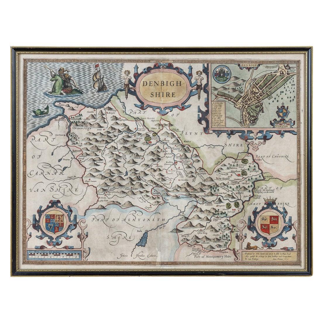
- 17th Century John Speed Map of Denbighshire, c.1610By John SpeedLocated in Royal Tunbridge Wells, KentAntique early 17th century British very rare and original John Speed, hand coloured map of Denbighshire, dated 1610, by John Sunbury and George Humble. John...Category
Antique 17th Century British Maps
MaterialsWood, Paper
- 17th Century Nicolas Visscher Map of Southeastern EuropeLocated in Hamilton, OntarioA beautiful, highly detailed map of southeastern Europe by Nicolas Visscher. Includes regions of Northern Italy (showing the cities Bologna, Padua, and Venice), Bohemia, Austria (sho...Category
Antique 17th Century Dutch Maps
MaterialsPaper
- 17th Century Map of Denmark by French Cartographer Sanson, Dated 1658By Nicolas SansonLocated in Copenhagen, K17th century map of Denmark by French cartographer Sanson. Nicolas Sanson (20 December 1600-7 July 1667) was a French cartographer, termed by some the creator of French geography an...Category
Antique 17th Century French Maps
MaterialsPaper
- 17th Century Topographical Map, French Champagne Region, Epernay, Iohan PeetersLocated in New York, NYFine topographical 17th century map by Iohan Peeters of the towns of Epernay and Lametz in the Champagne Region of North Eastern France. Fabulous period engraving for a Wine Cellar,...Category
Antique 17th Century Dutch Maps
MaterialsPaper
- 17th Century John Speed Map of the Barkshire Described, c.1616By John SpeedLocated in Royal Tunbridge Wells, KentAntique 17th century British very rare and original John Speed (1551-1629) map of the Barkshire Described, J. Sud and Georg Humble, publication (1616 or lat...Category
Antique 17th Century British Maps
MaterialsPaper


Recently Viewed
View AllMore Ways To Browse
1859 Asia Map
Antique Map Antilles
Antique Alabama Map
Antique Furniture Oklahoma City
J Beringer
Old Sicily Map
Antique Map Of Tuscany
Map Of Washington Dc
Washington Dc Map
Aigue Marine
Furniture Sellers In Israel
Inland Empire
Map Of Native American Tribes
Montana Maps
Op Ocean Pacific
1847 Rio
A Plan City And Castle Of Batavia
Carl Probst