Items Similar to Detailed Antique Map of the Black Sea, Balkans and Asia Minor


Want more images or videos?
Request additional images or videos from the seller
1 of 6
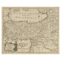
Detailed Antique Map of the Black Sea, Balkans and Asia Minor
About the Item
Antique map titled 'Nuova Carta del Europa Turchesca (..)'. This is an Italian version of Tirion's detailed map of the Black Sea, Balkans, and Asia Minor. It is embellished with a simple compass rose and provides a good view of the various political divisions. Published circa 1734.
It includes (parts of): Romania / Bulgaria / Moldova / Black Sea / Ukraine / Serbia / Albania / Turkey / Cyprus
Tirion was born in Utrecht in 1705. He moved to Amsterdam in 1725 and set up shop on Damrak as a book publisher. Tirion quick rose in prominence by publishing pamphlets, historical works, and, most importantly, maps and atlases. He eventually relocated his printing house to the prestigious Kalverstraat. In his long career he produced eight atlases in multiple editions, some of which were published posthumously until about 1784. Most of his cartographic work is based on the earlier maps of Guillaume de L'Isle.
- Dimensions:Height: 14.3 in (36.3 cm)Width: 17.33 in (44 cm)Depth: 0.02 in (0.5 mm)
- Materials and Techniques:
- Period:
- Date of Manufacture:c.1734
- Condition:General age-related toning. Original folding lines. Shows some wear, soiling and staining. Blank verso. Please study image carefully.
- Seller Location:Langweer, NL
- Reference Number:
About the Seller
5.0
Platinum Seller
These expertly vetted sellers are 1stDibs' most experienced sellers and are rated highest by our customers.
Established in 2009
1stDibs seller since 2017
1,957 sales on 1stDibs
Typical response time: <1 hour
- ShippingRetrieving quote...Ships From: Langweer, Netherlands
- Return PolicyA return for this item may be initiated within 14 days of delivery.
More From This SellerView All
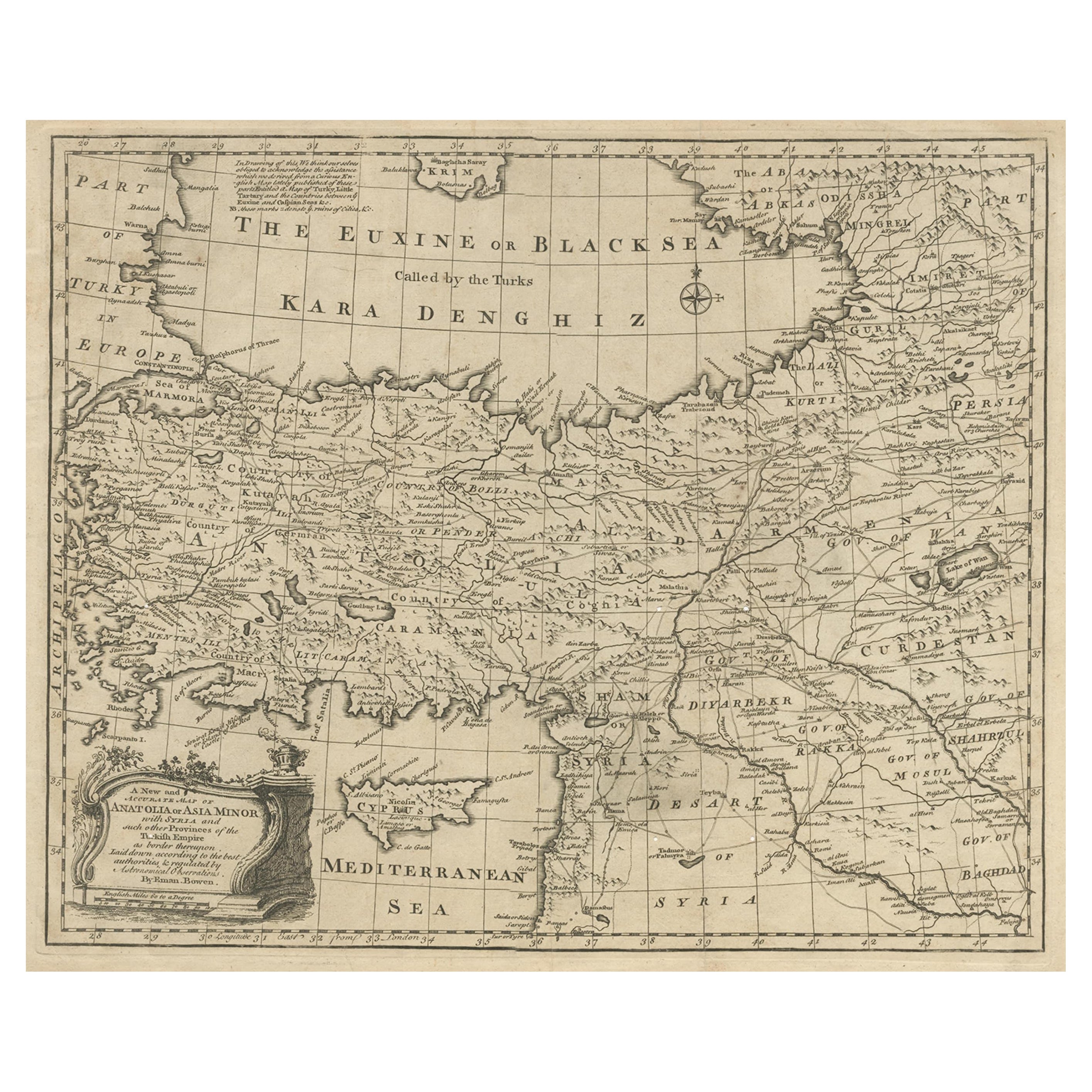
- Antique Map of Asia Minor with Cyprus, Syria and Turkey and the Black Sea, 1747Located in Langweer, NLAntique map Middle East titled 'A New and accurate map of Anatolia or Asia Minor, with Syria and such other provinces of the Turkish Empire (.....Category
Antique 18th Century Maps
MaterialsPaper
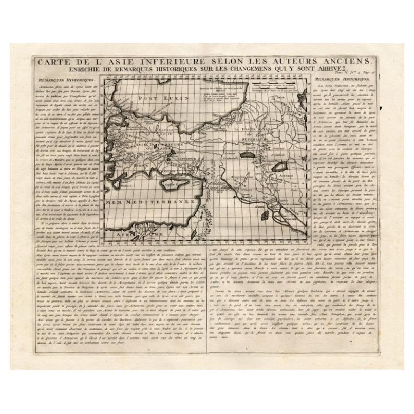
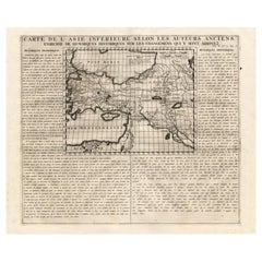
- Detailed Antique Map of Asia Minor & Cyprus with Historical Notes, 1732Located in Langweer, NLAntique map titled 'Carte De L'Asie Inferieure Selon Les Auteurs Anciens (..)'. Detailed map of Asia Minor & Cyprus. With historical notes. This original old antique print / plate or...Category
Antique 18th Century Maps
MaterialsPaper
- Antique Map of Asia Minor, Cyprus, and the Eastern MediterraneanLocated in Langweer, NLAntique map titled 'Natoliae quae olim Asia Minor nova descriptio'. Original antique map of Asia Minor, Cyprus, and the eastern Mediterranean. Originally published on one sheet toget...Category
Antique Early 17th Century Maps
MaterialsPaper
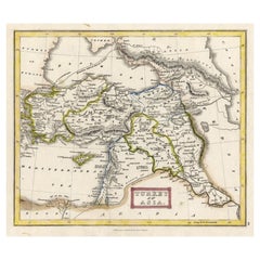
- Antique Map of Turkey in Asia 'Asia Minor', 1841Located in Langweer, NLAntique map titled 'Turkey in Asia'. Original antique map of Asia Minor (Turkey). Source unknown, to be determined. Artists and Engravers: Published by O...Category
Antique 19th Century Maps
MaterialsPaper
- Original Antique Map of Turkey, Asia Minor and CyprusBy Gerard MercatorLocated in Langweer, NLAntique map titled 'Natoliae sive Asia Minor'. Original old map of Turkey, Asia Minor and Cyprus. Includes a decorative cartouches, sailing ship, sea mon...Category
Antique Early 17th Century Maps
MaterialsPaper
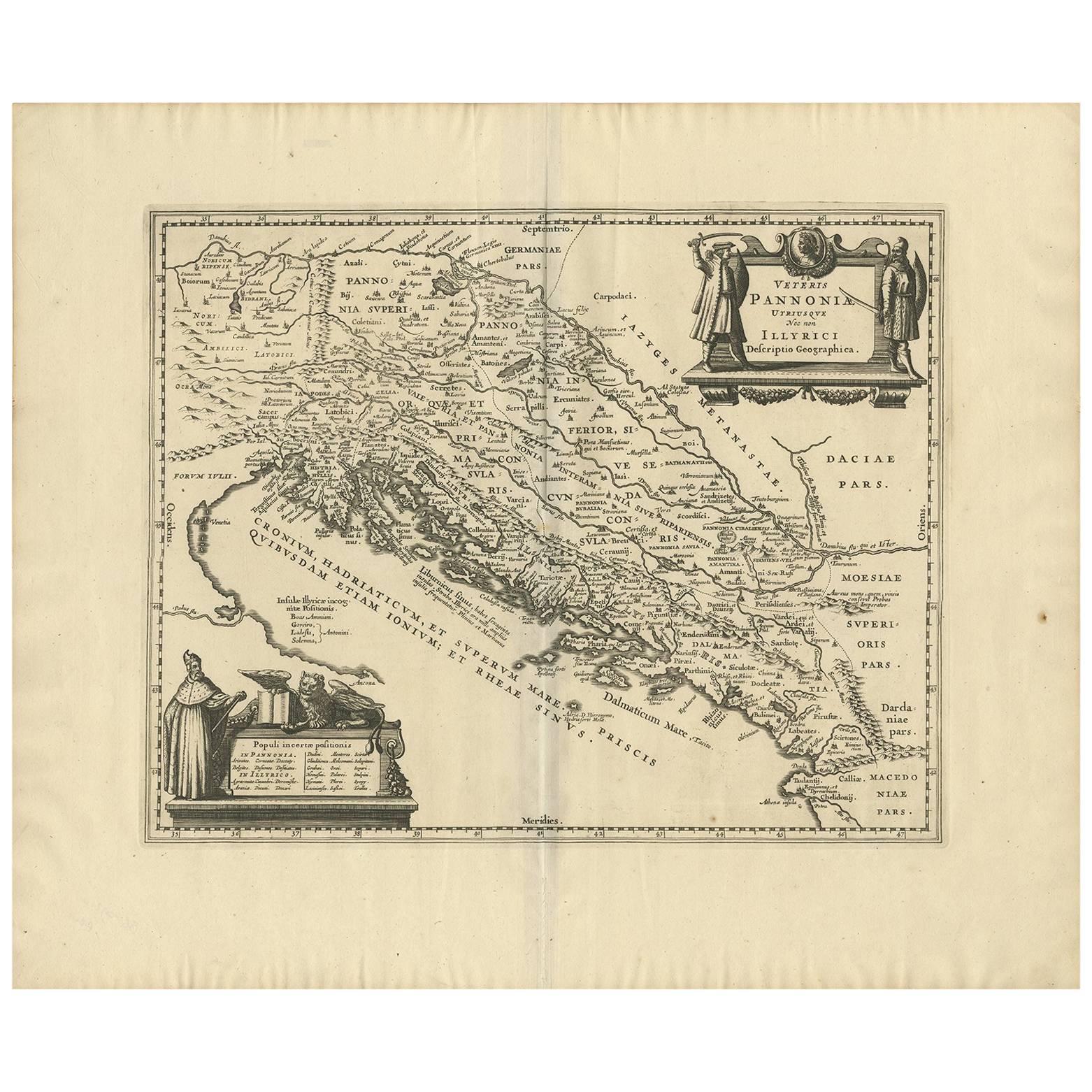
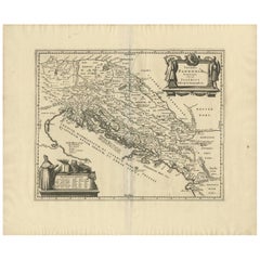
- Antique Map of the Adriatic Sea and the Balkan by J. Janssonius, circa 1650Located in Langweer, NLStriking large-scale map of the Greater Balkans. Decorated with two large-scale cartouches, one showing two swordsman at odds with one another and the other ...Category
Antique Mid-17th Century Maps
MaterialsPaper


You May Also Like
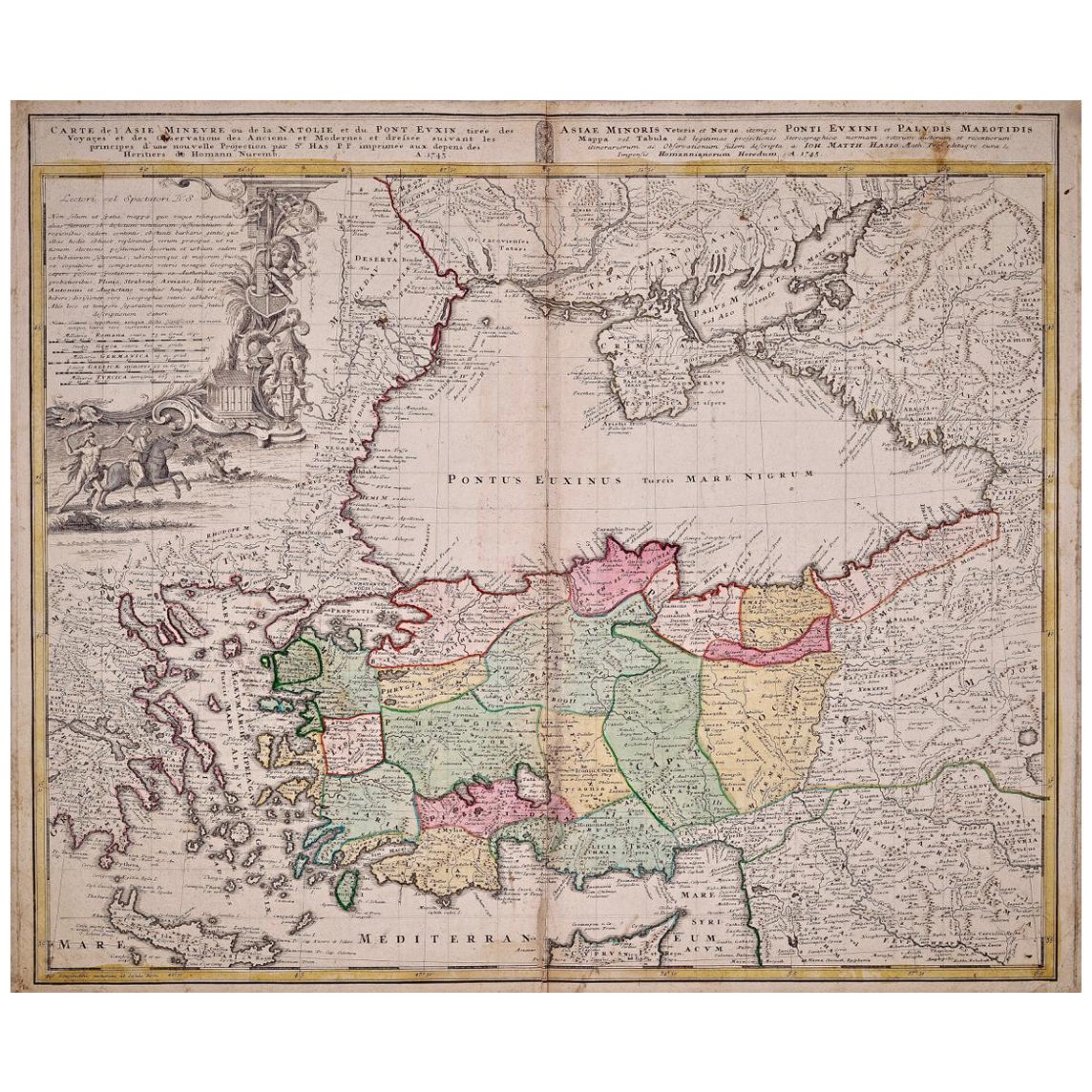
- Hand-Colored 18th Century Homann Map of the Black Sea, Turkey and Asia MinorBy Johann Baptist HomannLocated in Alamo, CAAn attractive original early 18th century hand-colored map of the Black Sea and Turkey entitled "Carte de L'Asie Minevre ou de la Natolie et du Pont Evxin Tiree des Voyages et des Ob...Category
Antique Early 18th Century German Maps
MaterialsPaper
- Original Antique Map of Asia. C.1780Located in St Annes, LancashireGreat map of Asia Copper-plate engraving Published C.1780 Two small worm holes to right side of map Unframed.Category
Antique Early 1800s English Georgian Maps
MaterialsPaper

- 18th Century Map of the Southern Balkans by Giovanni Maria CassiniBy Giovanni Maria CassiniLocated in Hamilton, Ontario18th century map by Italian engraver Giovanni Maria Cassini (Italy 1745-1824). Map of the Southern Balkans: Rome. Hand colored and copper engraved print done in the year 1788. It in...Category
Antique 18th Century Italian Maps
MaterialsPaper
- Antique Lithography Map, Black Sea, English, Framed, Cartography, VictorianLocated in Hele, Devon, GBThis is an antique lithography map of the Black Sea region. An English, framed atlas engraving of cartographic interest by John Rapkin, dating to the early Victorian period and later...Category
Antique Mid-19th Century British Early Victorian Maps
MaterialsWood
- Original Antique Map of South East Asia, Arrowsmith, 1820Located in St Annes, LancashireGreat map of South East Asia Drawn under the direction of Arrowsmith Copper-plate engraving Published by Longman, Hurst, Rees, Orme and Brown, 1820 Unframed.Category
Antique 1820s English Maps
MaterialsPaper
- Antique Carte de L'Inde Myanmar, Malaysia Vietnam Map of Asia the Chinese EmpireLocated in Amsterdam, Noord HollandAntique Carte de L'Inde Myanmar, Malaysia Vietnam Map of Asia the Chinese Empire Very nice map of Asia. Additional information: Type: Map Country of Man...Category
Antique 18th Century European Maps
MaterialsPaper


Recently Viewed
View AllMore Ways To Browse
Map Of The Netherlands
Italian Maps
Antique Old World Maps
Paris Antique Map
Vintage Map World
Vintage Maps World
Furniture From Portugal Antique
Map Of Indonesia
United States Antique Map
Antique Map Coats Of Arms
Antique North American Map
Antique North American Maps
New York Antique Maps
Old Compass
Antique Book Map France
Antique Map Of South Of France
Office Depot
Old Maps England