Items Similar to Lyonnais, Beaujolais, Forez, Mâconnais: A 1644 Depiction of France's Provinces

Want more images or videos?
Request additional images or videos from the seller
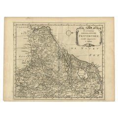
Lyonnais, Beaujolais, Forez, Mâconnais: A 1644 Depiction of France's Provinces
About the Item
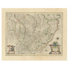
An original antique map from 1644, depicting the French provinces of Lyonnais, Beaujolais, Forez, and Mâconnais. In this map, north is oriented to the right, which is a cartographic convention not commonly used today but seen in historical maps. The map includes various geographical details such as rivers, towns, and regional borders, and is embellished with a decorative cartouche and coat of arms, illustrating the region's heraldry and the mapmaker's artistic flair typical of the period.
The map is made and published by Willem & Joan Blaeu. From: Theatrum Orbis Terrarum.. J. Blaeu, 1644-45.
The Blaeu family, comprising Willem Janszoon, Cornelis, and Joan, were preeminent figures in 17th-century cartography and publishing. Willem Janszoon Blaeu, born in 1571 near Alkmaar, Netherlands, was an accomplished student of mathematics and astronomy under Tycho Brahe. He established himself in Amsterdam in 1596, becoming a noted globe, instrument, and map-maker. His significant contributions to maritime cartography began with a globe in 1599 and expanded to include the pilot guide "Het Licht der Zeevaert" and an appointment as Hydrographer to the V.O.C. by 1633. His establishment of the Blaeu publishing house marked a new era of atlas-making, beginning with the "Atlas Appendix" in 1630.
Competition with neighbor and fellow mapmaker Johannes Janssonius in Amsterdam prompted Willem to adopt his grandfather's nickname 'Blaeu' to distinguish himself. After his death in 1638, his sons Cornelis (whose contributions are lesser-known) and Joan continued the business. Joan, succeeding his father at the V.O.C., became famous for the "Atlas Major" and extensive town-books of the Netherlands and Italy, cementing the Blaeu legacy in cartography.
Tragedy struck in 1672 when a fire destroyed the Blaeu business, and Joan Blaeu died a year later. The remnants of their extensive collection were auctioned off, ending up in the hands of various Amsterdam booksellers and publishers. The Blaeu printing house, once a towering name in cartographic publishing, concluded its operations with a final auction in 1695.
- Dimensions:Height: 20.08 in (51 cm)Width: 23.82 in (60.5 cm)Depth: 0 in (0.02 mm)
- Materials and Techniques:Paper,Engraved
- Period:1640-1649
- Date of Manufacture:circa 1644
- Condition:Condition: Good, given age, general age-related soiling and toning. Folding line as issued. Large damp stains in the outer margin - not touching the image. French text on the reverse. Please study scan carefully.
- Seller Location:Langweer, NL
- Reference Number:
About the Seller
5.0
Platinum Seller
These expertly vetted sellers are 1stDibs' most experienced sellers and are rated highest by our customers.
Established in 2009
1stDibs seller since 2017
1,950 sales on 1stDibs
Typical response time: <1 hour
- ShippingRetrieving quote...Ships From: Langweer, Netherlands
- Return PolicyA return for this item may be initiated within 14 days of delivery.
More From This SellerView All
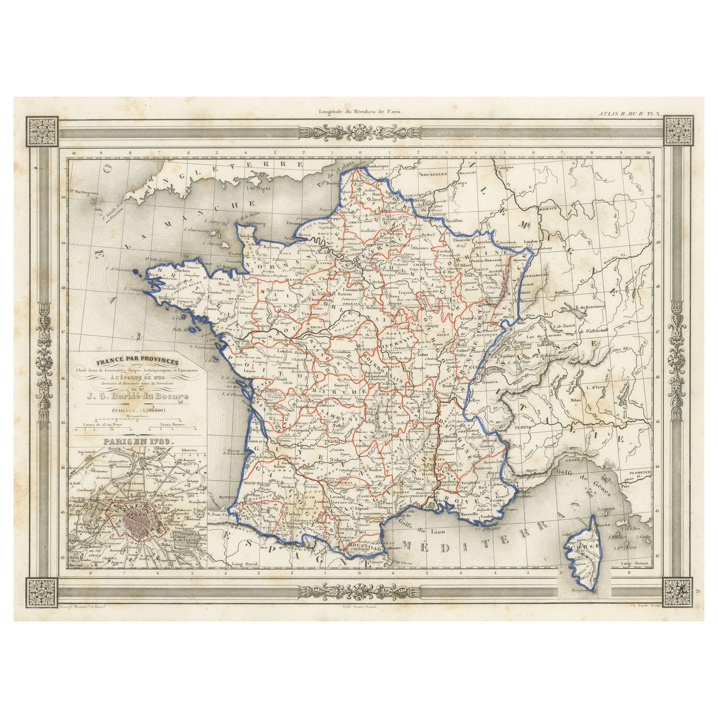
- Antique Map of France in Provinces, with Inset of ParisLocated in Langweer, NLAntique map titled 'France par Provinces'. Original antique map of France in Provinces. It covers from the Flanders in the north to Roussillon in the south and from Brittany in the w...Category
Antique Mid-19th Century Maps
MaterialsPaper
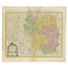
- Antique Map of the Region of Lyonnais by Janssonius, '1657'By Johannes JanssoniusLocated in Langweer, NLAntique map 'Lionnois, forest, beauviolois et masconnois'. Decorative map of the Lyonnais region, France. The Lyonnais is a historical province of France which owes its name to the c...Category
Antique Mid-17th Century Maps
MaterialsPaper
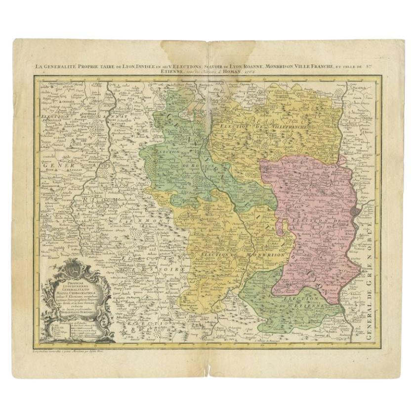
- Antique Map of the Region of Lyonnais by Nolin, 1697Located in Langweer, NLUntitled map of the French Province of Lyonnais, with its capital at Lyon, on the upper Loire and Rhone rivers. This map is a single sheet and part of a two sheet map titled 'The Gen...Category
Antique 17th Century Maps
MaterialsPaper
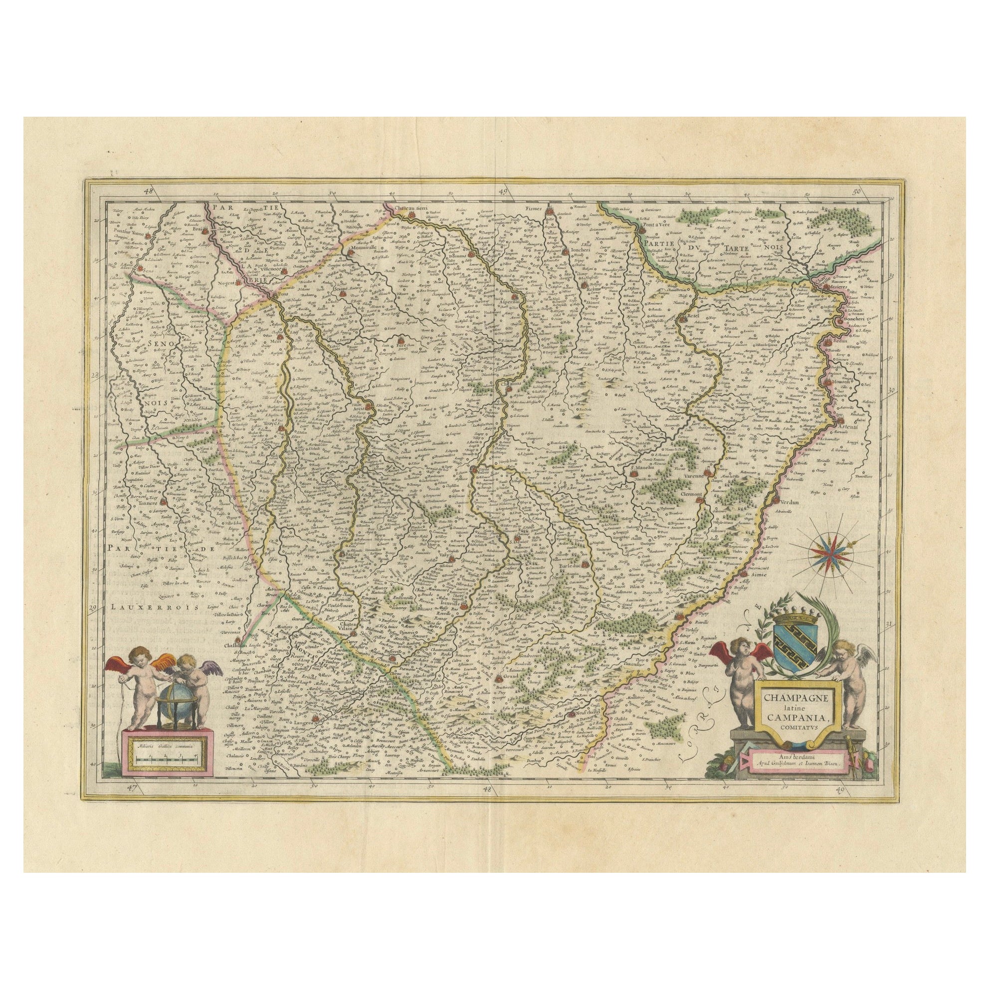
- Authentic 1644 Janssonius Map of the Champagne Region (Campania) in FranceLocated in Langweer, NL"1644 Janssonius Map of Champagne, France" This meticulously detailed original antique map, engraved in 1644, is a work by the esteemed cartographer Johannes Janssonius. It depicts the historic province of Champagne, situated in the northeastern part of France. The map is notable for its high level of detail, with meticulously drawn boundaries, city markers, and river courses. It features a beautifully rendered cartouche adorned with the provincial coat of arms, flanked by classical figures, indicative of the region's cultural significance. In the lower left corner, a pair of cherubs are engaged in surveying, symbolizing the scientific endeavor of cartography. The elaborate compass rose and the scale bar further complement the map's utility and artistic merit. Champagne is renowned globally for its viticultural heritage, being the birthplace of the eponymous Champagne sparkling wine. The region's unique terroir, with its chalky soil and cool climate, is ideal for the production of the grapes used in champagne-making. The historical significance of Champagne extends beyond winemaking; it has been the site of pivotal battles and royal coronations, which shaped the course of French and European history. This map is not only a navigational tool but also a snapshot of a region rich in history and tradition, an artifact that embodies the geographical and cultural prestige of Champagne. This description provides a detailed visual and contextual presentation of the map, suitable for a catalog entry, emphasizing both its artistic features and the historical and cultural importance of the Champagne region. THE WINE AREAS: The Champagne region, known primarily for its production of the sparkling wine that bears its name, encompasses several important cities and sites of historical and cultural significance: 1. **Reims**: Often considered the unofficial capital of the Champagne region, Reims is renowned for its grand cathedral, Notre-Dame de Reims, where French kings were historically crowned...Category
Antique 1640s Maps
MaterialsPaper
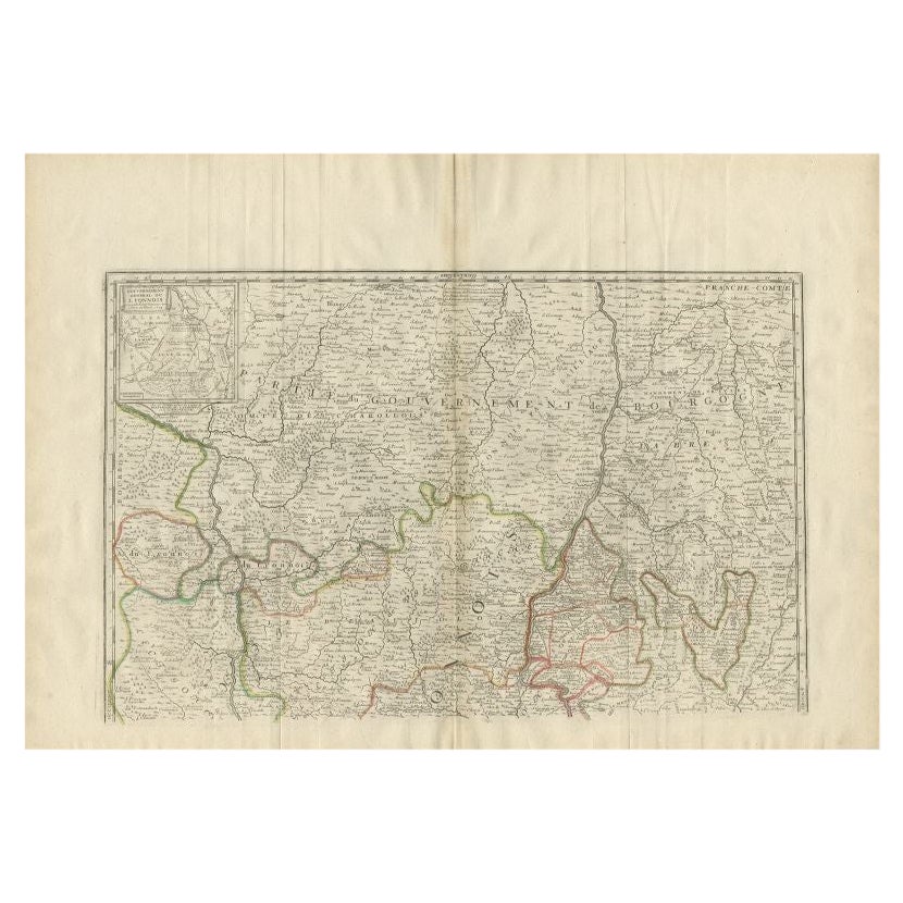
- Antique Map of the Beaujolais Region by Homann Heirs, 1762Located in Langweer, NLAntique map titled 'La Generalite Proprie Taire De Lyon (..) - Propriae Lugudunensis Generalitatis (..)'. Detailed regional map of the Beaujolais region including the cities of Lyon,...Category
Antique 18th Century Maps
MaterialsPaper
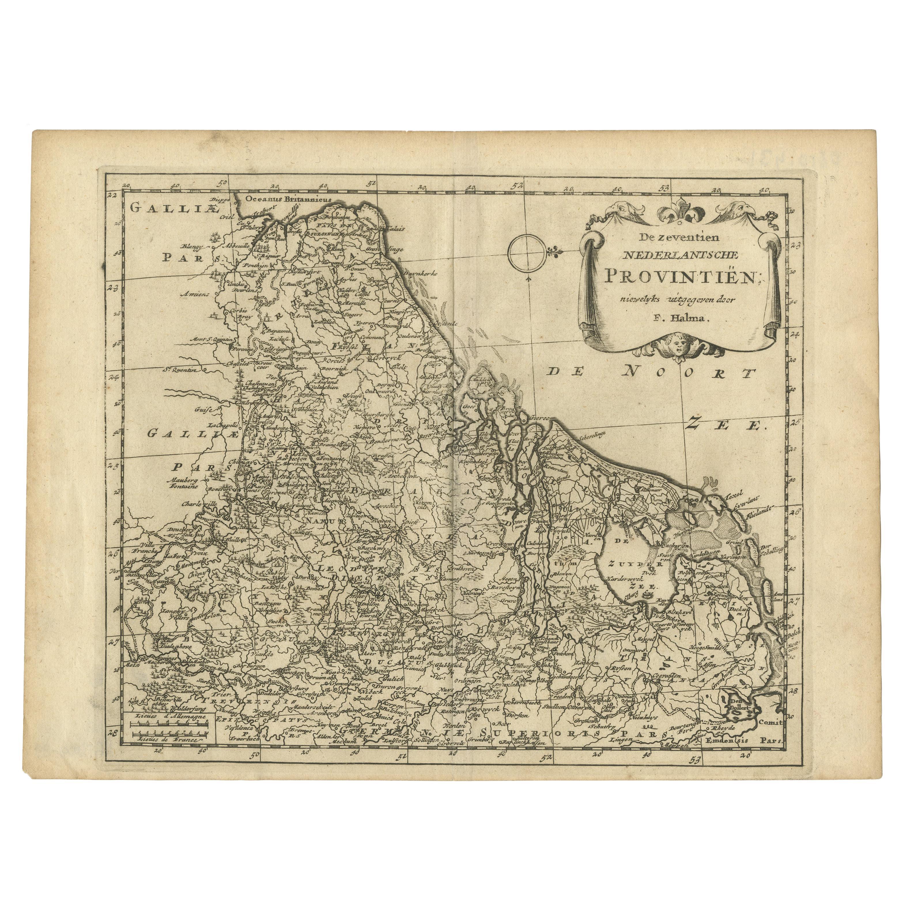
- Antique Map of the Seventeen Provinces by Halma '1705'Located in Langweer, NLAntique map titled 'De zeventien Nederlantsche Provintiën'. Original antique map of the Seventeen Provinces, the Imperial states of the Habsburg Netherlands in the 16th century. This...Category
Antique Early 18th Century Maps
MaterialsPaper


You May Also Like
- Jewel pietradura walking stick depicting the rape of Europa, France 1870.Located in Milan, ITWalking Stick knob made out of green quartz semi-precious stone, oval enamel miniature painted on copper, depicting the rape of Europa and the bull. 18...Category
Antique Late 19th Century French Collectible Jewelry
MaterialsQuartz, Metal, Gold
- 19th Century French Enamel Plaque Depicting 'The Finding of Moses'Located in London, GBThis fine enamel plaque is notable both for its large size and the exquisite contrast produced between the rich, blue enamel backdrop against the grey foreground, created using the g...Category
Antique Late 19th Century French Paintings
MaterialsEnamel
- Decorative Plate Depicting the Scene of the Apparition in Lourdes, FranceBy RosenthalLocated in Chorzów, PLDecorative plate depicting the scene of the apparition in Lourdes, France. Dimensions: diameter 19 cm.Category
1990s French Other Religious Items
MaterialsPorcelain
- Antique Puzzle of Colored Cardboard Depicting World Map, Europe and FranceLocated in Milan, ITEducational puzzle of colored cardboard composed of three folders depicting world map, Europe and France. The world map in addition to the territorial map of the continents depicts t...Category
Antique 1850s French Games
MaterialsPaper
- Lithographic print on paper depicting the muscular system of a neck, France 1850Located in Milan, ITAn anatomical lithographic print on paper, depicting a cross section of the muscular system of the neck. Black lacquered fir wood frame with golden ramin wood batting...Category
Antique Mid-19th Century French Prints
MaterialsGlass, Wood, Paper


Recently Viewed
View AllMore Ways To Browse
1859 Asia Map
Antique Map Antilles
Antique Alabama Map
Antique Furniture Oklahoma City
J Beringer
Old Sicily Map
Antique Map Of Tuscany
Map Of Washington Dc
Washington Dc Map
Aigue Marine
Furniture Sellers In Israel
Inland Empire
Map Of Native American Tribes
Montana Maps
Op Ocean Pacific
1847 Rio
A Plan City And Castle Of Batavia
Carl Probst