Items Similar to Map of Japanese Coast from Osaka to Tokyo & the Kyushu and Shikoku Islands, 1669

Want more images or videos?
Request additional images or videos from the seller
1 of 5
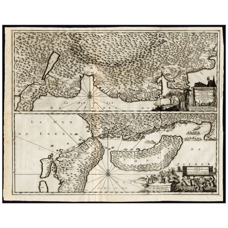
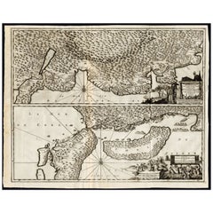
Map of Japanese Coast from Osaka to Tokyo & the Kyushu and Shikoku Islands, 1669
About the Item
Antique map titled 'De Land Reyse van Osacca to Iedo. De Water eyse van Nangasacqui tot Osacca.'
Two maps on one sheet. The top map shows the Japanese coast from Osaka to Tokyo (Jedo). The lower map shows the strait between mainland Japan and the two large islands (Kyushu and Shikoku) to the south. This stretches from Osaka to Nagasaki. Originates from 'Gedenkwaerdige Gesantschappen der Oost-Indische Maatschappy in 't Vereenigde Nederland aan de Kaisaren van Japan (..)' by A. Montanus.
Artists and Engravers: Arnoldus Montanus (c.1625–1683) was a Dutch teacher and author. He published books on theology, history, and geography.
Condition: Good, general age-related toning. Professionally restored on folding lines, please study image carefully.
- Dimensions:Height: 17.92 in (45.5 cm)Width: 21.66 in (55 cm)Depth: 0 in (0.02 mm)
- Materials and Techniques:
- Period:1660-1669
- Date of Manufacture:1669
- Condition:Repaired: Professionally restored on folding lines. Wear consistent with age and use.
- Seller Location:Langweer, NL
- Reference Number:
About the Seller
5.0
Platinum Seller
These expertly vetted sellers are 1stDibs' most experienced sellers and are rated highest by our customers.
Established in 2009
1stDibs seller since 2017
1,947 sales on 1stDibs
Typical response time: <1 hour
- ShippingRetrieving quote...Ships From: Langweer, Netherlands
- Return PolicyA return for this item may be initiated within 14 days of delivery.
More From This SellerView All
- Antique Map of the Region of Osaka and Hirado Island in Japan, 1725By Pieter Van Der AaLocated in Langweer, NLAntique map titled 'Description exacte et fidele des villes, bourgs et villages qui les Ambassadeurs de Hollande ont rencontrez dans leur voyage par terre de la ville Osacca jusqu'a ...Category
Antique 18th Century Maps
MaterialsPaper
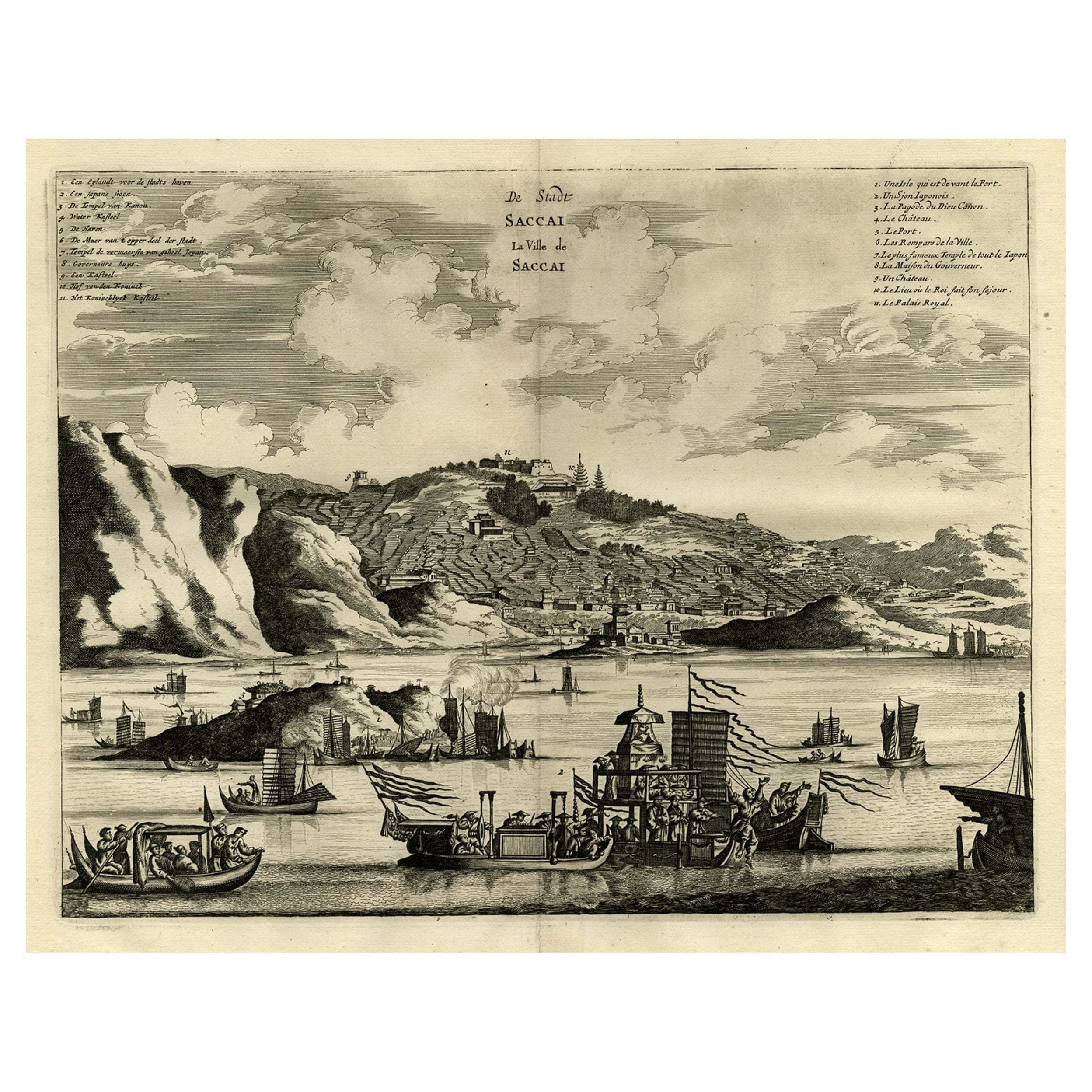
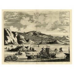
- Original Antique Engraving of Sakai in the Osaka Prefecture, Japan, 1669Located in Langweer, NLAntique print, titled: 'De Stadt Saccai. La Ville de Saccai.' - ('The City Saccai'). This plate shows a view of Sakai in the Osaka Prefecture, Japan. Sakai has been one of the la...Category
Antique 1660s Maps
MaterialsPaper
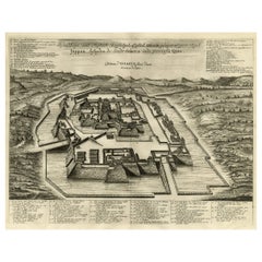
- Original Antique Engraving of the Mighty Imperial Osaka Castle in Japan, 1669Located in Langweer, NLAntique print, titled: 'Afbeeldinge vant Maghtich Keyserlyck Casteel Osacca geleegen int groot Ryck Jappan besuyden de Stadt Osacce inde provinsie Qioo.' - ('Image of the Mighty Imperial Castle Osaka'). A bird's eye view of Osaka Castle, Japan. Arnoldus Montanus' "Gedenkwaerdige Gesantschappen der Oost-Indische Maatschappy in 't Vereenigde Nederland aan de Kaisaren van Japan […]. Amsterdam: Jacob Meurs, 1669. Artists and Engravers: Made by an anonymous engraver after 'Arnoldus Montanus'. Condition: Very good, given age. Original middle fold, as issued. Some faint browning of the margin edges. A few small spots in the margins (from paper making...Category
Antique 1660s Maps
MaterialsPaper
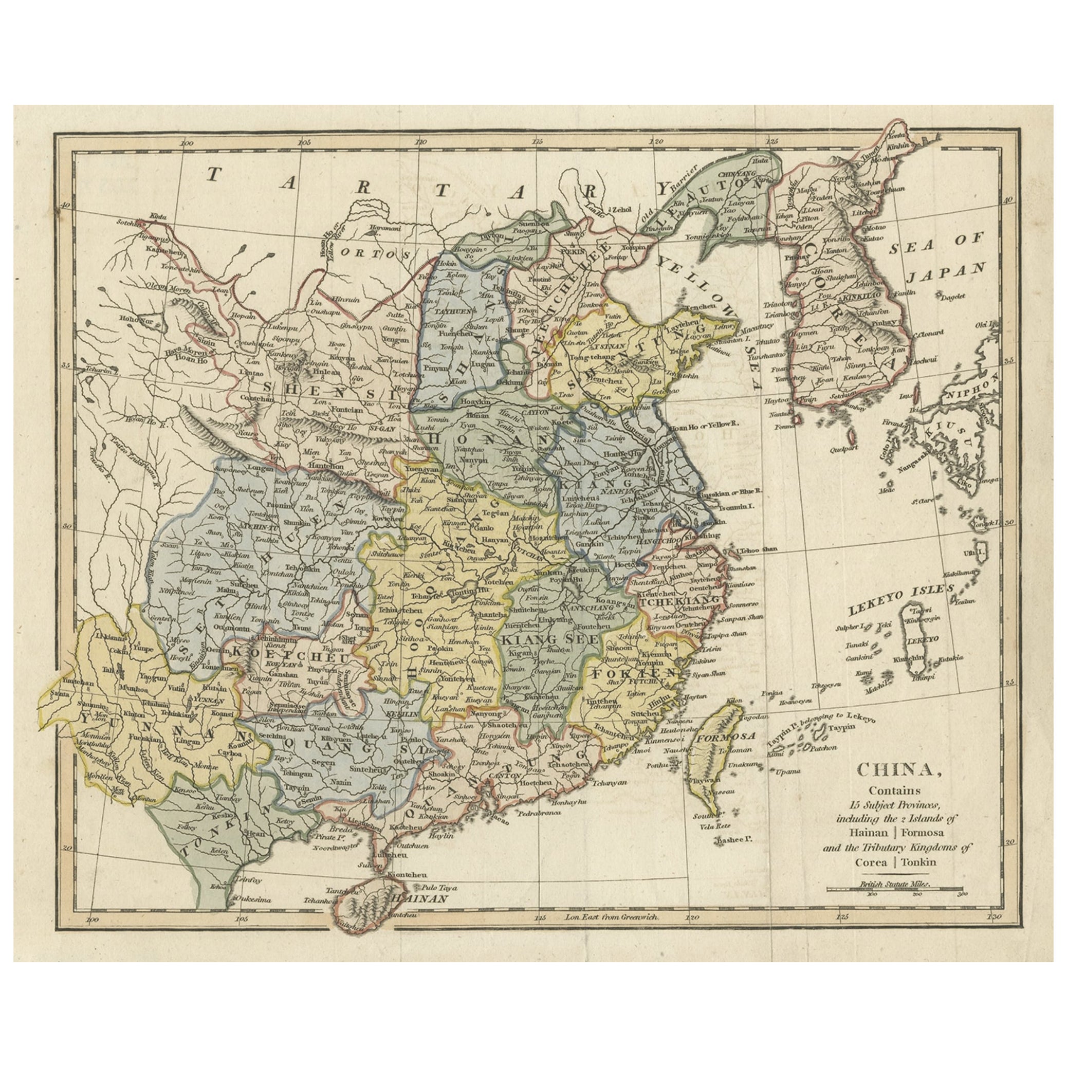
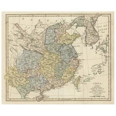
- Original Old China Map, From Korea and the Sea of Japan to Teypin Island, 1803Located in Langweer, NLAntique map titled 'China, Contains 15 Subject Provinces Including the 2 Islands of Hainan, Formosa and the Tributary Kingdoms of Corea, Tonkin'. Old map depicting China, extendi...Category
Antique Early 1800s Maps
MaterialsPaper
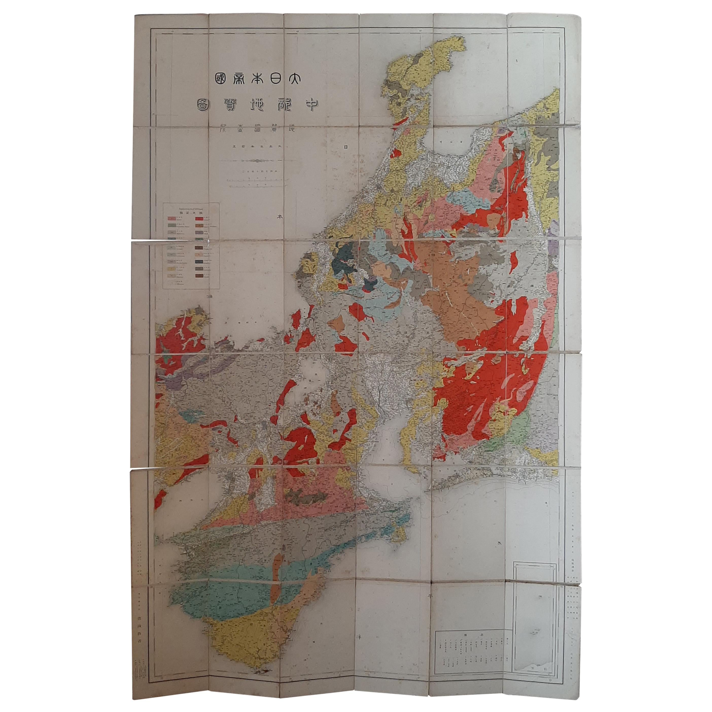
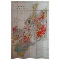
- Antique Map of the Region of Wakayama, Nara and Osaka 'Japan'Located in Langweer, NLGeological folding map of the area with Wakayama, Nara, Osaka, Mie, and Shiga in Japan, circa 1880: This map is a geological folding map, which means it was designed to be portable ...Category
Antique Late 19th Century Maps
MaterialsLinen, Paper
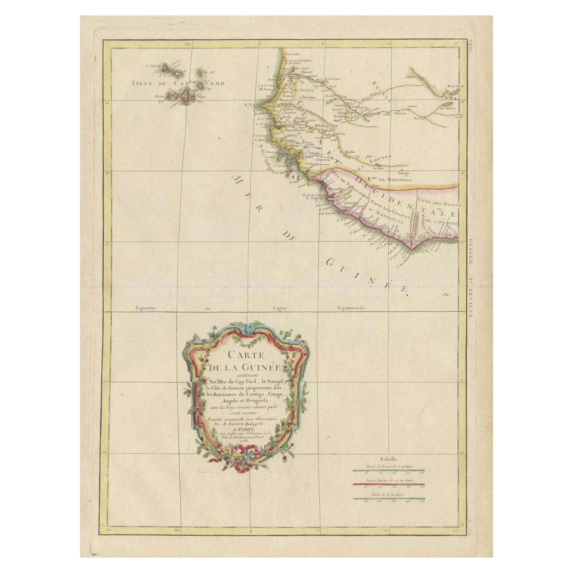
- Antique Map of the Coast of Guinea and the Cape Verde IslandsLocated in Langweer, NLAntique map titled 'Carte de la Guinée (..)'. This map was originally part of a 2 sheet larger map of Eastern Africa, showing the Cape Verde Islands and Senegal. This map originates ...Category
Antique Late 18th Century Maps
MaterialsPaper
You May Also Like
- Hand-Colored 18th Century Homann Map of Denmark and Islands in the Baltic SeaBy Johann Baptist HomannLocated in Alamo, CAAn 18th century copper plate hand-colored map entitled "Insulae Danicae in Mari Balthico Sitae utpote Zeelandia, Fionia, Langelandia, Lalandia, Falstria, Fembria Mona" created by Joh...Category
Antique Early 18th Century German Maps
MaterialsPaper
- New Map of North America from the Latest Discoveries, 1763Located in Philadelphia, PAA fine antique 18th century map of the North American seaboard. Entitled "A New Map of North America from the Latest Discoveries 1763". By the Cartographer/Engraver - John Spil...Category
Antique Mid-18th Century English Georgian Maps
MaterialsPaper
- Vintage "View of the Center of Paris Taken from the Air" Lithograph MapLocated in San Diego, CAA very stylish "View of the Center of Paris Taken from the Air" lithograph map published by the Paris Ministry of Tourism, circa early 1950s. The piece measures 27" x 43" and shows...Category
20th Century French Mid-Century Modern Prints
MaterialsPaper
- Map of the Republic of GenoaLocated in New York, NYFramed antique hand-coloured map of the Republic of Genoa including the duchies of Mantua, Modena, and Parma. Europe, late 18th century. Dimension: 25...Category
Antique Late 18th Century European Maps
- Italy, Sicily, Sardinia, Corsica and Dalmatian Coast: A 17th Century Dutch MapBy Theodorus DanckertsLocated in Alamo, CAThis hand colored 17th century Dutch map entitled "Novissima et Accuratissima totius Italiae Corsicae et Sardiniae Descriptio" by Theodore Danckerts depicts the Italian Peninsula in ...Category
Antique Late 17th Century Dutch Maps
MaterialsPaper
- Map "Estuary- Mouth of the Thames"Located in Alessandria, PiemonteST/426 - Antique French Map of the estuary of the Thames, map dated 1769 - "Mape of the entrance of the Thames. Designed by filing of Navy cards fo...Category
Antique Mid-18th Century French Other Prints
MaterialsPaper


Recently Viewed
View AllMore Ways To Browse
Tokyo Used Furniture
Antique Tokyo
Antique Furniture Tokyo
Map Japan
Japan Maps
Map Of Japan
Antique Japanese Maps
Antique Japanese Map
Antique Map Of Japan
Antique Map Japan
T Nagasaki
Antique Furniture East London
Antique Eastern European Furniture
Antique House Plans
Antique Metal Window
Antique Metal Windows
Antique Furniture Rollers
Antiques Compasses