Items Similar to Rare Antique Map of Part of Europe and Africa by Scherer, C.1703
Want more images or videos?
Request additional images or videos from the seller
1 of 5
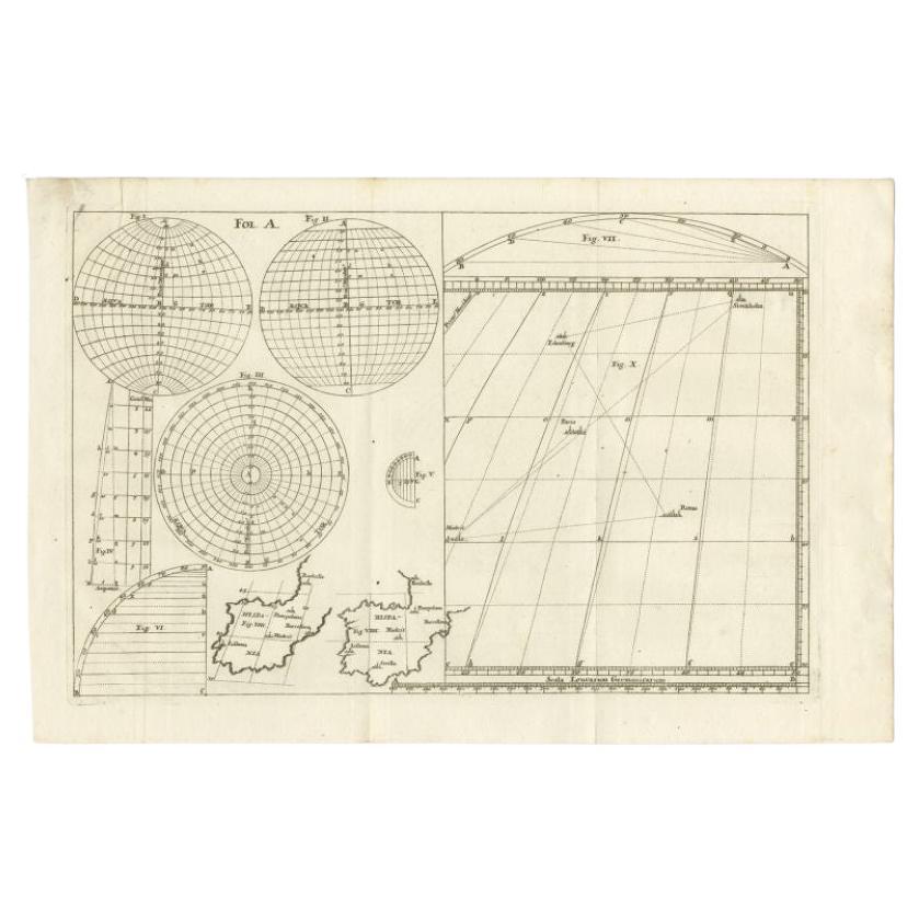
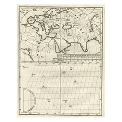
Rare Antique Map of Part of Europe and Africa by Scherer, C.1703
About the Item
Antique map with two figures. The upper figures showing part of Europe and Africa. Below a chart. Printed for Scherer's 'Atlas Novus' (1702-1710). Artists and Engravers: Heinrich Scherer (1628-1704) was a Professor of Hebrew, Mathematics and Ethics at the University of Dillingen until about 1680. Thereafter he obtained important positions as Official Tutor to the Royal Princes of Mantua and Bavaria. It was during his time in Munich as Tutor to the Princely house of Bavaria that his lifetime's work as a cartographer received acclaim and recognition. Scherer's world atlas, the Atlas Novus, first published in Munich between 1702 and 1710 and reissued in a second edition between 1730 and 1737, forms a singularly unusual, almost revolutionary work in terms of the development of European mapmaking at the beginning of the 18th Century.
Artist: Heinrich Scherer (1628-1704) was a Professor of Hebrew, Mathematics and Ethics at the University of Dillingen until about 1680. Thereafter he obtained important positions as Official Tutor to the Royal Princes of Mantua and Bavaria. It was during his time in Munich as Tutor to the Princely house of Bavaria that his lifetime?s work as a cartographer received acclaim and recognition. Scherer?s world atlas, the Atlas Novus, first published in Munich between 1702 and 1710 and reissued in a second edition between 1730 and 1737, forms a singularly unusual, almost revolutionary work in terms of the development of European mapmaking at the beginning of the 18th Century.
Condition: Very good. General age-related toning. Please study image carefully.
Date: c.1703
Overall size: 21 x 27 cm.
Image size: 18 x 23 cm.
Antique prints have long been appreciated for both their aesthetic and investment value. They were the product of engraved, etched or lithographed plates. These plates were handmade out of wood or metal, which required an incredible level of skill, patience and craftsmanship. Whether you have a house with Victorian furniture or more contemporary decor an old engraving can enhance your living space. We offer a wide range of authentic antique prints for any budget.
- Dimensions:Height: 10.63 in (27 cm)Width: 8.27 in (21 cm)Depth: 0 in (0.01 mm)
- Materials and Techniques:
- Period:
- Date of Manufacture:circa 1703
- Condition:Condition: Very good. General age-related toning. Please study image carefully.
- Seller Location:Langweer, NL
- Reference Number:
About the Seller
5.0
Platinum Seller
These expertly vetted sellers are 1stDibs' most experienced sellers and are rated highest by our customers.
Established in 2009
1stDibs seller since 2017
1,946 sales on 1stDibs
Typical response time: <1 hour
- ShippingRetrieving quote...Ships From: Langweer, Netherlands
- Return PolicyA return for this item may be initiated within 14 days of delivery.
More From This SellerView All
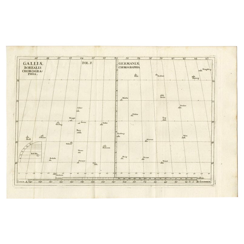
- Antique Map of part of Europe by Scherer, c.1703Located in Langweer, NLUntitled map of Europe depicting Calais, Münster, Paris, Lion, Prag, Wien, Berlin, Clermont and many other cities. Printed for Scherer's 'Atlas Novus' (1702-1710). Artists and Engrav...Category
Antique 18th Century Maps
MaterialsPaper
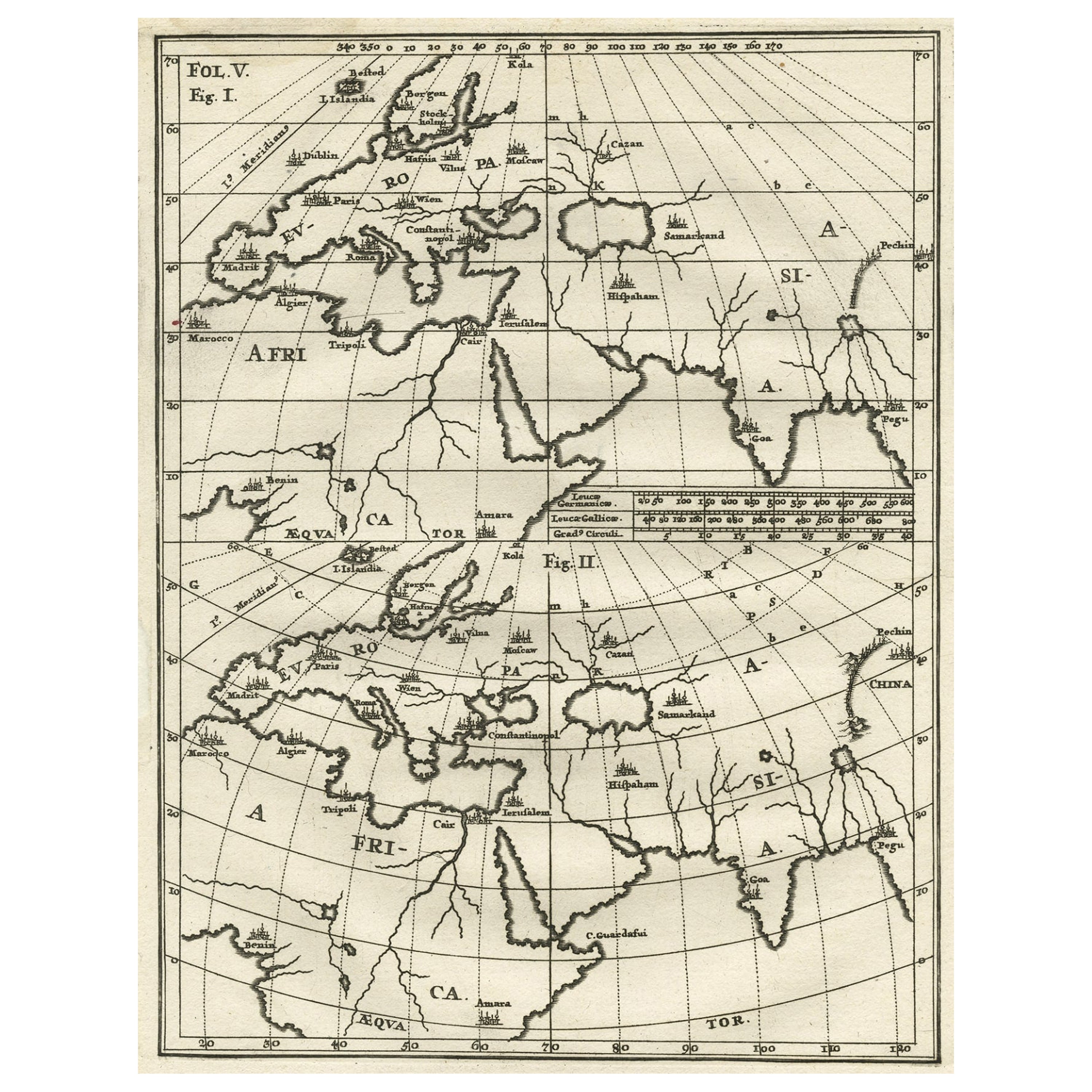
- Intriguing Antique Map of Europe, Asia and Africa by Scherer, c.1703Located in Langweer, NLTwo maps on a single sheet showing Europe, Asia and Africa, each depicting nearly the same area. On close examination there are slight differences. Major cities are located. Printed ...Category
Antique 18th Century Maps
MaterialsPaper
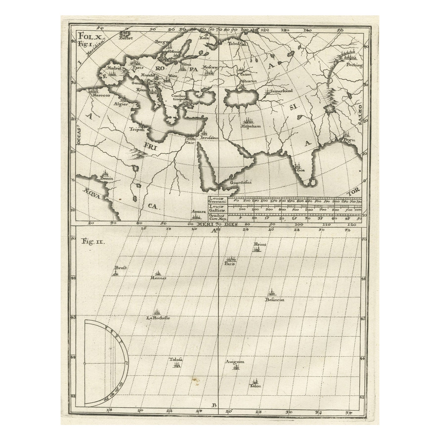
- Intriguing Antique Map of Europe, the Middle East and Africa by Scherer, c.1703Located in Langweer, NLAntique map depicting part of Africa, Europe and the Middle East. Also showing various cities in the lower chart. Printed for Scherer's 'Atlas Novus' (1702-1710). Artists and Eng...Category
Antique 18th Century Maps
MaterialsPaper
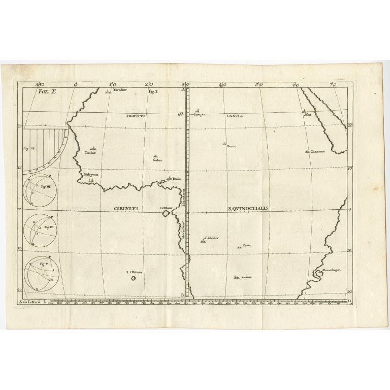
- Remarkable Antique Map of Central Africa by Scherer, c.1703Located in Langweer, NLUntitled map of Central Africa depicting Tarodant, Lempta, Guber, Borno, Chaxumo, Tombut, Melegvete, Benin, S. Salvator, Zaire, Gondar, S. Helena and Mozambique. Printed for Scherer'...Category
Antique 18th Century Maps
MaterialsPaper
- Antique Map of Western Europe and Spain by Scherer, circa 1703Located in Langweer, NLUntitled map of Western Europe and Spain. Depicting Rome, Edinburgh, Paris, Madrid, Stockholm and various Spanish cities. Printed for Scherer's 'Atlas Novus' (1702-1710). Artists...Category
Antique 18th Century Maps
MaterialsPaper
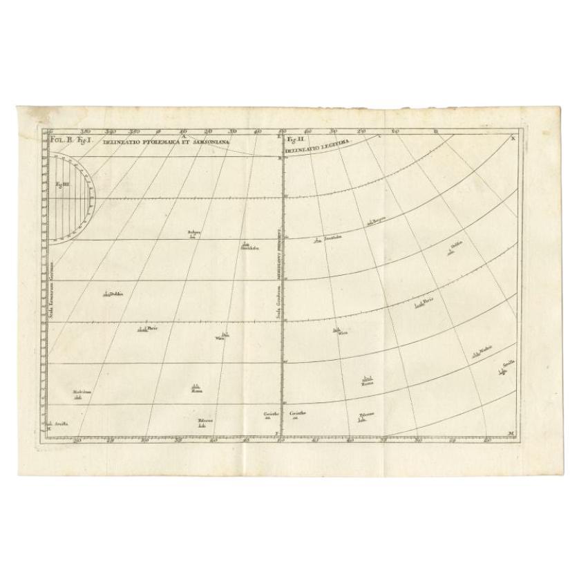
- Remarkable Antique Map of West Europe by Scherer, circa 1703Located in Langweer, NLAntique map of Western Europe. Depicting Bergen, Stockholm, Dublin, Paris, Wien, Madrid, Rome, Sevilla, Palermo and Corintho. Printed for Scherer's 'Atlas Novus' (1702-1710). Artists...Category
Antique 18th Century Maps
MaterialsPaper
You May Also Like
- Antique Hand Colored Framed Map of EuropeLocated in West Palm Beach, FLAntique reproduction copied from an edition dated 1595 by Ortelius.Category
Antique Late 19th Century Maps
- Original Antique Map of Europe, Arrowsmith, 1820Located in St Annes, LancashireGreat map of Europe Drawn under the direction of Arrowsmith. Copper-plate engraving. Published by Longman, Hurst, Rees, Orme and Brown, 1820 ...Category
Antique 1820s English Maps
MaterialsPaper
- Large Original Antique Map of Europe by Sidney Hall, 1847Located in St Annes, LancashireGreat map of Europe Drawn and engraved by Sidney Hall Steel engraving Original colour outline Published by A & C Black. 1847 Unframed Free shipping.Category
Antique 1840s Scottish Maps
MaterialsPaper
- Original Antique Map of South Africa, Arrowsmith, 1820Located in St Annes, LancashireGreat map of South Africa. Drawn under the direction of Arrowsmith. Copper-plate engraving. Published by Longman, Hurst, Rees, Orme and Br...Category
Antique 1820s English Maps
MaterialsPaper
- Antique Puzzle of Colored Cardboard Depicting World Map, Europe and FranceLocated in Milan, ITEducational puzzle of colored cardboard composed of three folders depicting world map, Europe and France. The world map in addition to the territorial map of the continents depicts t...Category
Antique 1850s French Games
MaterialsPaper
- London 1744 Published Watercolour Antique Map of East Africa by Eman BowenLocated in GBWe are delighted to offer for sale this New and Accurate Map of Nubia & Abissinia, together with all the Kingdoms Tributary Thereto, and bordering upon them published in 1744 by Emanuel Bowen This is a decorative antique engraved map of East Africa...Category
Antique 1740s English George III Maps
MaterialsPaper


Recently Viewed
View AllMore Ways To Browse
Antique Decor And More
Antique Prince And
Antique European Plates
Munich Antiques
18th Century African
Bavaria Antique
African Plate
Antique Hebrew
Old Maps Of Europe
Old Europe Map
Antique African Figures
Victorian African
Bavaria Plate
Antique Bavaria
Plate Heinrich
Antique World Chart
18c Engraved Prints
Antique Africa Maps And Atlases Africa Maps